1 - 8 of 8
Number of results to display per page
Search Results
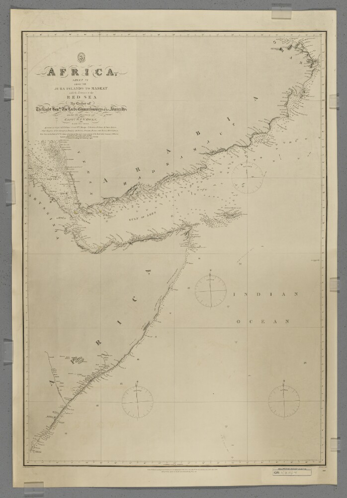
1. 'Africa, Sheet VI from the Juba Islands to Maskat with the Entrance to the Red Sea'
- Description:
- Abstract: Chart 598.Hydrographic chart covering the Horn of Africa north of the Juba [Bajun] Islands, the southern coast of the Arabian Peninsula to Maskat [Muscat], the western Indian Ocean, the Gulf of Aden and the southern Red Sea. Portrays hydrology, including depths by soundings and some contours, sands and rocks, relief by hachures and occasional spot heights, settlements and place names, and includes topographical notes and navigational aids, including lights highlighted in watercolour.Chart compiled under the direction of Captain William Fitzwilliam Owen from 1822 to 1826, assisted by Captain Alexander Thomas Emeric Vidal and lieutenants William Mudge, Thomas Boteler, Richard Owen, Edward Owen Johnes and Messrs Rogier, Arlett, Durnford, Badgley, Robinson, Bowen and Mercer, Midshipmen. North of 10°N the chart is compiled from reductions of more recent surveys by 'the East India Company's Officers'. Engraved by J & C Walker. Published by the Admiralty 1827, with corrections 1868, 1873, 1875, November 1876, December 1876, May 1877 and September 1877.Physical description: Materials: Printed, with watercolour additions, on paperDimensions: 870 x 600mm, on sheet 982 x 669mm
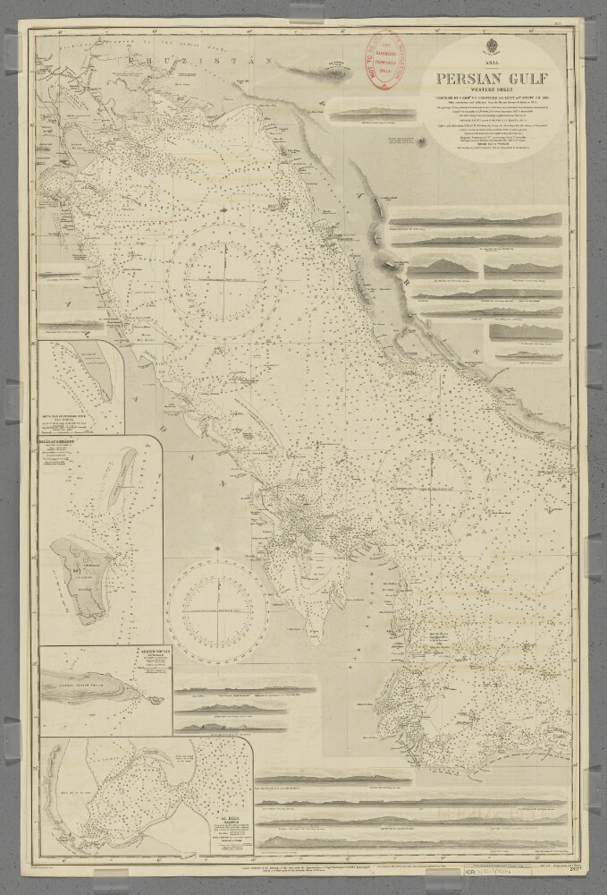
2. 'Persian Gulf. Western Sheet'
- Description:
- Abstract: Chart 2837b.Hydrographic chart covering the Persian Gulf from Al Basra, Mesopotamia [Al Basrah, Iraq] westwards to approximately longitude 53° 20’E. Also includes the adjacent coastal areas of Persia [Iran], Mesopotamia and the eastern Arabian Peninsula. Portrays hydrology, including depths by soundings and contours, anchorages, sands and rocks, relief by spot heights, hachures and rock drawings, vegetation, settlements, forts and place names, and includes topographical notes and navigational aids, including lights and prominent landmarks.Includes insets of Ras Tanura, Arabia [Ras Tannurah, Saudi Arabia] at scale 1:18,360; Kharag [Kharg] & Khargu, Persia [Iran] at scale 1:72,913; Henjam Sheikh Shu'aib, Persia [Lavan Island] at scale 1:121,520; and Al Bida, Al Katr [Al Bid', Qatar] at scale 1:60,760.Eighteen annotated sketches of significant navigational views at unspecified scales on both the north and south coasts are also included.Chart surveyed and compiled by Commander Charles Golding Constable and Lieutenant Arthur William Stiffe, Indian Navy (1860); also incorporates surveys by Captain John Michael Guy and Captain George Barnes Brucks, East India Marine (1821-29); with corrections and additions from the Marine Survey of India to 1911. Engraved by J & C Walker. Published at the Admiralty 1862, with new editions 1876, 1890, 1900, 1903 and 1912, and small corrections.The sheet bears the stamps:'Not to be used for navigation. For reference purposes only' in red on the map face.The number '30.2' in black in the upper right margin.Physical description: Materials: Printed on paperDimensions: 964 x 622mm, on sheet 1020 x 666mm
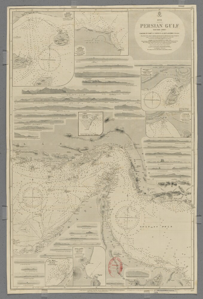
3. 'Persian Gulf. Eastern Sheet'
- Description:
- Abstract: Chart 2837a.Hydrographic chart covering the Strait of Hormuz and the adjoining sections of the Persian Gulf and Gulf of Oman. Also includes the adjacent coastal areas of Persia [Iran] and the Musandam Peninsula. Portrays hydrology, including depths by soundings and contours, anchorages, sands and rocks, relief by spot heights, hachures and rock drawings, vegetation, settlements, forts and place names, and includes topographical notes and navigational aids, including lights and prominent landmarks.Includes insets of Kishm, Persia [Qeshm, Iran] at scale 1:145,826; Kais to Bandar Abbas, Persia [Kish to Bander-e Abbas] at scale 1:72,913; Henjam Island, Persia [Hengam Island] at scale 1:145,826; Charak, Persia [Bandar-e Charak] at scale 1:145,826; Chiru, Persia [Bandar-e Chiruyeh] at scale 1:72,913; Khor Fakan, Oman [Khawr Fakkan, United Arab Emirates] at scale 1:60,760; and Abu Thabi, Trucial Oman [Abu Dhabi, United Arab Emirates] at scale 1:72,913.Thirty-three annotated sketches of significant navigational views at unspecified scales on both the north and south coasts are also included.Chart surveyed and compiled by Commander Charles Golding Constable and Lieutenant Arthur William Stiffe, Indian Navy (1860); also incorporates surveys by Captain John Michael Guy and Captain George Barnes Brucks, East India Marine (1821-1829); with corrections by Commander Frederic Henry Walter and Lieutenant H T Bowen, Royal Navy (1910). Engraved by J & C Walker. Published at the Admiralty 1862, with new editions 1865, 1890, 1910, 1911 and 1912, and small corrections.The sheet bears the stamps:'Not to be used for navigation. For reference purposes only' in red on the map face.The number '20.2' in black in the upper right margin.Physical description: Materials: Printed on paperDimensions: 960 x 636mm, on sheet 1003 x 665mm
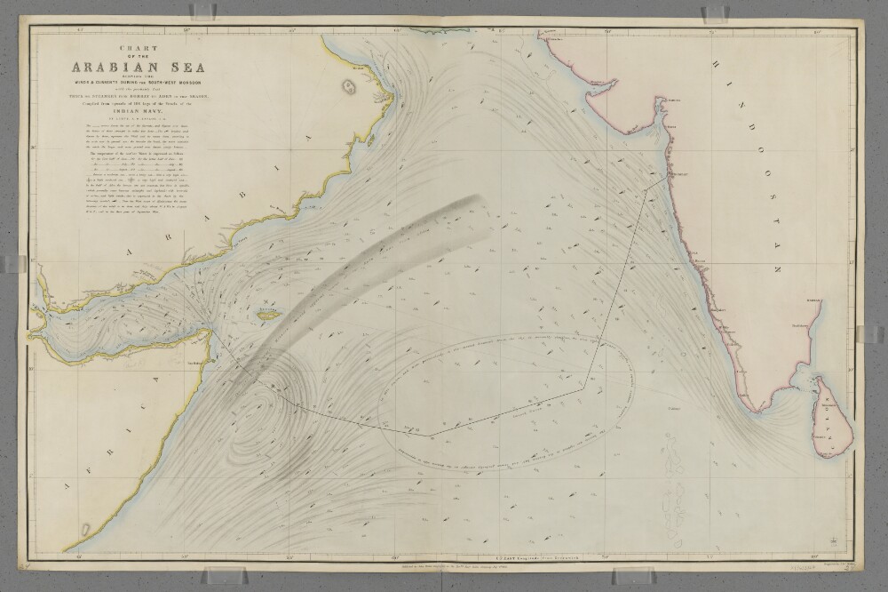
4. 'Chart of the Arabian Sea Shewing the Winds & Currents during the South-West Monsoon with the probably best Track for Steamers from Bombay to Aden in that Season.'
- Description:
- Abstract: Covers the Arabian Sea south of latitude 25°N, including the Gulf of Aden. Includes the coastlines of the Horn of Africa, the south-east Arabian Peninsula and the west coast of India. Includes a hinterland of approximately fifteen miles. Portrays hydrology, including rocks, relief by hachures, settlements, place names, and includes some navigational notes. Also shows meteorological information, including the strength and direction of currents and winds, surface water temperatures and sea turbulence, and includes meteorological notes and a suggested route for shipping between Aden and Bombay [Mumbai, India]. The chart has been enhanced with watercolour and some place names and routes added in pencil.Compiled by Lieutenant Alfred Dundas Taylor, Indian Navy. Engraved by J & C Walker. Published by John Walker, Geographer to the Honourable East India Company.Physical description: Materials: Printed, with manuscript additions in watercolour and pencil, on paper (backed with linen)Dimensions: 619 x 987mm, on sheet 654 x 1004mm
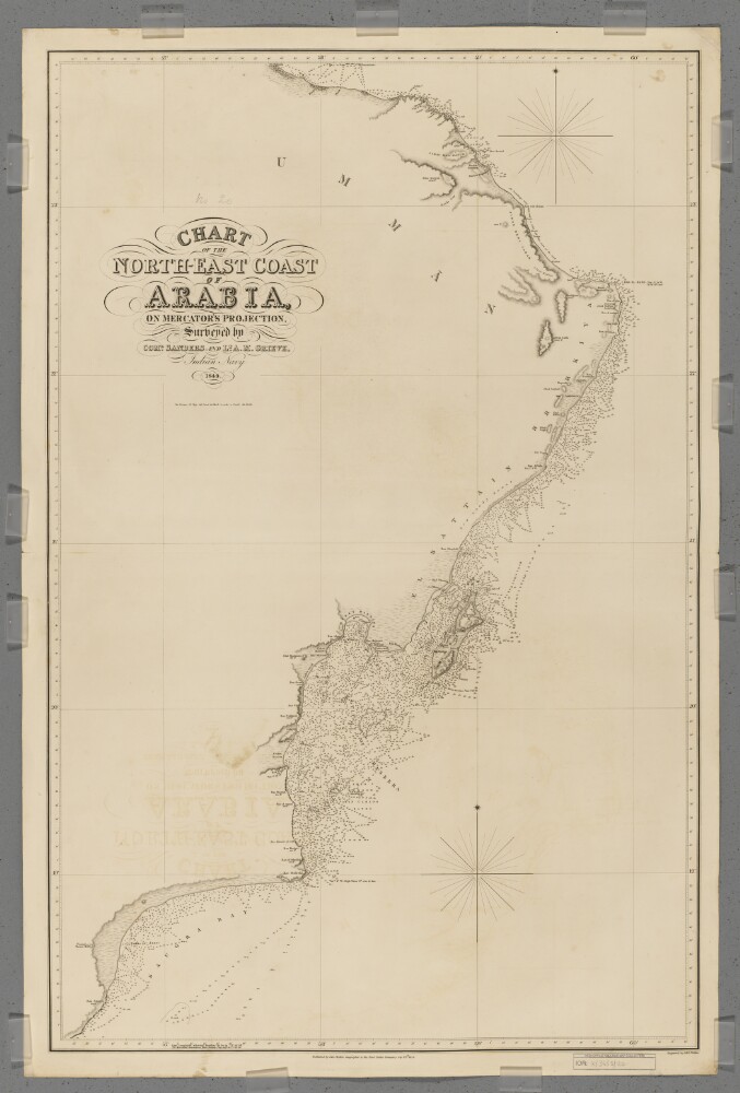
5. 'Chart of the North-East Coast of Arabia'
- Description:
- Abstract: Covers a 380-mile length of the Arabian Sea coast of Umman [Oman] from Ras Saugra [Ra's Sawqirah] north-eastwards to Ras el Hadd [Ra's al Hadd], and then a 150-mile length of the Gulf of Aden coast north-westwards to Muskat [Muscat]. Includes a hinterland of approximately twenty miles. Portrays hydrology, including depths by soundings and some contours, relief by spot heights, hachures and rock drawing, sand dunes, vegetation, settlements, tribal lands and place names, and includes topographical and hydrographic notes.Surveyed by Commander I P Sanders [most likely John Parke Sanders] and Lieutenant Albany Moore Grieve, Indian Navy. Engraved by J & C Walker. Published by John Walker, Geographer to the East India Company.Physical description: Materials: Printed on paper (backed with linen)Dimensions: 941 x 604mm, on sheet 1011 x 673mm
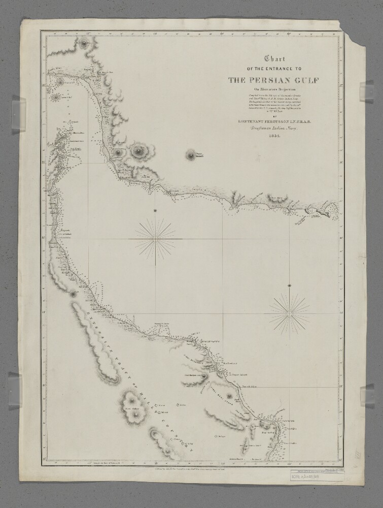
6. 'Chart of the Entrance to the Persian Gulf'
- Description:
- Abstract: Covers the eastern part of the Strait of Hormuz, the western part of the Gulf of Oman and the coastlines of southern Persia [Iran], northern Oman and the eastern side of the Musandam Peninsula, including a hinterland of approximately thirty miles. Portrays hydrology, including depths by soundings, sands and rocks, relief by hachures, rock drawing and occasional spot heights, vegetation, settlements, forts and place names, and includes topographical notes.Compiled by Lieutenant E F T Fergusson, Indian Navy from the surveys of Commander George Barnes Brucks and Lieutenants Stafford Bettesworth Haines and Albany Moore Grieve, Indian Navy, 1854. Engraved by J & C Walker. Published by John Walker, Geographer to the Honourable East India Company, 1857.Physical description: Materials: Printed on paperDimensions: 426 x 620mm, on sheet 678 x 508mm
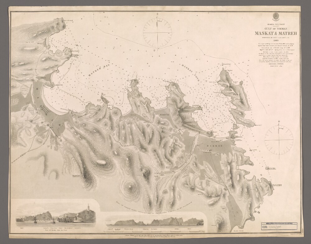
7. 'Maskat & Matreh'
- Description:
- Abstract: Chart 2869.Hydrographic chart covering a four-mile length of the Omani coast from Maskat [Muscat] north-eastwards to Matreh [Mutrah] on the Gulf of Oman. Portrays hydrology, including depths by soundings and contours, sands, mud and rocks, anchorages, relief by spot heights and hachures, vegetation, cultivation, roads, paths, walls, settlements and public buildings, military buildings, wells and place names, and includes topographical notes and navigational aids, including prominent buildings.Includes annotated sketch views, at unspecified scales, of Maskat from the north-north-east and the approach to Maskat Cove [Khawr Masqat] from the north-north-west.Surveyed by Lieutenant Arthur William Stiffe, Indian Navy, 1860, with upright soundings from Lieutenant Ward, 1849, and the sloping soundings from Lieutenant George Barnes Brucks and Lieutenant Stafford Bettesworth Haines, 1828. Engraved by J & C Walker. Published at the Admiralty, 1862.Physical description: Materials: Printed on paperDimensions: 481 x 624mm, on sheet 508 x 643mm
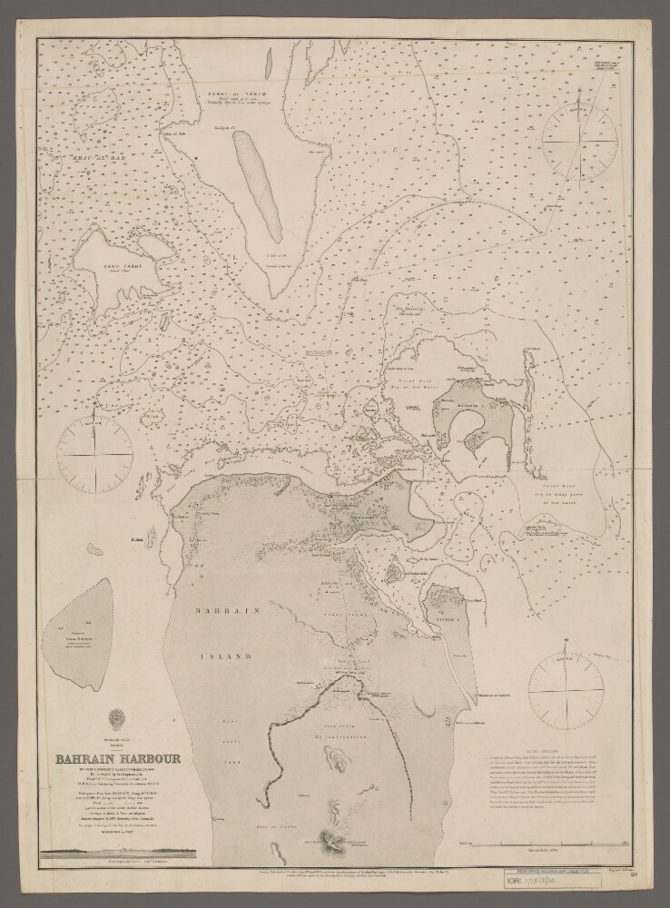
8. 'Bahrain Harbour'
- Description:
- Abstract: Chart 20.Hydrographic chart covering the northern half of Bahrain Island and Maharak [Muharraq] Island in the western part of the Persian Gulf. Portrays hydrology, including depths by soundings and contours, sands, rocks, reefs and anchorages, relief by hachures, vegetation, settlements, forts and place names, and includes topographical notes and navigational aids, including buoys and prominent buildings. There is a view of the Portuguese Fort and textual sailing directions into Bahrain Harbour.By Commander Charles Golding Constable and Lieutenant Richard William Whish, Indian Navy, 1860. Re-surveyed by M Chapman, Indian Navy, Messrs A P Thompson & C J Cuthbert, Her Majesty's Indian Surveying Schooner Constance, 1872-74. Upright soundings in hair line by Lieutenant George Barnes Brucks, Indian Navy, 1825. Engraved by J & C Walker. Published by the Admiralty, 1862, with corrections 1873 and 1875.Physical description: Materials: Printed on paperDimensions: 668 x 481mm, on sheet 707 x 514mm