1 - 4 of 4
Number of results to display per page
Search Results
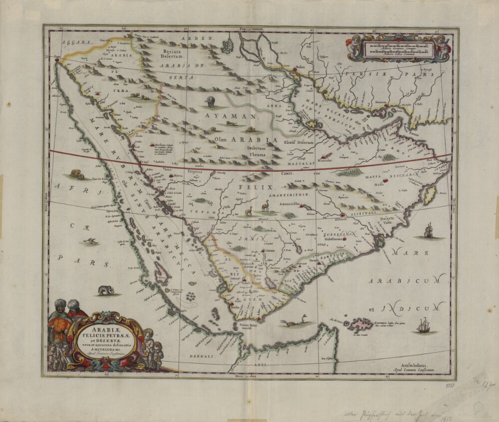
1. A Current and Correct Depiction of Arabia Felix, Arabia Petraea, and Arabia Deserta
- Description:
- Abstract: This map from 1658 was published by Johannes Janssonius (1588-1664), or Jan Jansson. Jansson was born in Arnhem, the son of Jan Jansson the Elder, a publisher and bookseller. Jansson’s maps are similar to those of Willem Janszoon Blaeu (1571-1638), the founder of the Blaeu cartographic firm, and Jansson is sometimes accused of copying from his rival, but many of his maps predate those of Blaeu or cover different regions. This map is very similar to an earlier Blaeu map. The map shows more rivers on the Arabian Peninsula, six in total, than on many other maps. Some town names are badly copied, such as “Bocealima,” which is Blaeu’s “Roccalima.” “Mascalat” is shown as a large and important town. There are dotted lines along the coast from “Calva” in the present-day United Arab Emirates (UAE) to beyond Bahrain Island. The Arabian Gulf is called “Mare elcatif olim Sinus Persicus” (Al Qatif Sea formerly known as the Persian Gulf) and the Strait of Hormuz called “Basora fretum” or Strait of Basra. The Red Sea is called “Mare Rubrum turcis Mare Mecca olim Sinus Arabicus” (Red Sea, named Sea of Mecca by Turks and formerly known as the Arabian Gulf).Physical description: 1 map; color; 42 x 49.50 centimeters
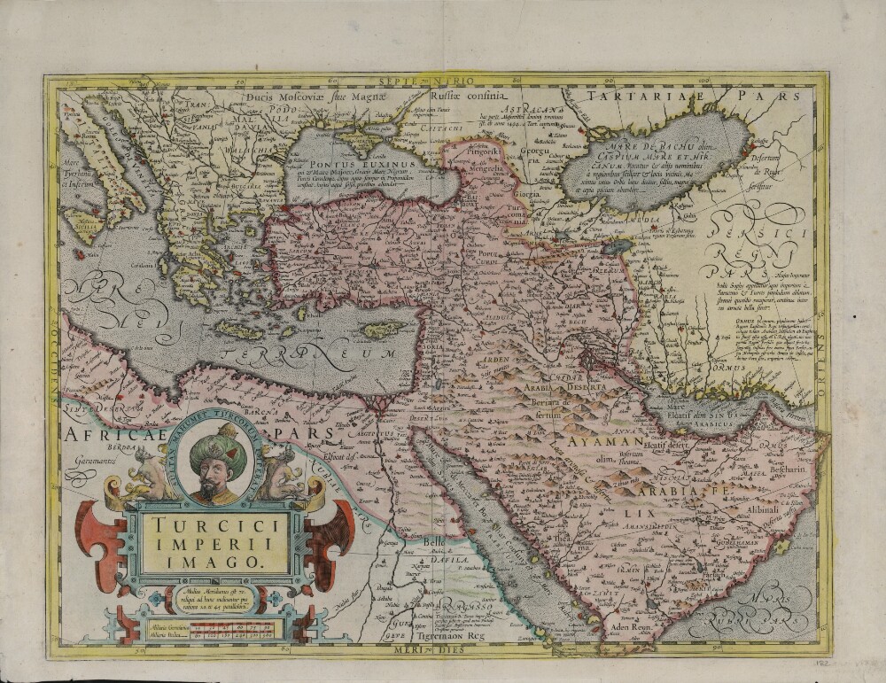
2. Map of the Turkish Empire
- Description:
- Abstract: This map shows the Ottoman Empire as it appeared in the early 17th century. It details Ottoman territories in Asia, Africa, and Europe, and includes Persia, Transcaucasia, Ethiopia, and other surrounding lands. Topographic features, place-names, and populations are definitively marked, although the nomenclature of the time differs markedly from that used today. The Red Sea is termed the Sea of Mecca, for example, and the Persian Gulf is called the Sea of Alcatif. The map sometimes has been identified as a part of Atlas sive Cosmographicae Meditationes de Fabrica Mundi et Fabricati figura (Atlas of the world: finely engraved and drawn), produced by Jodocus Hondius following the work of Gerard Mercator. There is no evidence on the map itself to sustain that identification, nor is a date of publication supplied. Ottoman lands are hand-colored in red, except for the European territories. The vivid coloring is not contemporary with the production of the map and was probably added in the 19th century after Greece and the Balkan lands, which are not colored, were freed from Ottoman rule. Different lettering denotes different geographic and ethnographic features. Italics are generously used, and geometric shapes and shading are used to indicate mountain ranges and maritime littorals. The title cartouche indicates that Hondius, the supposed creator, based his map on Mercator’s projection. The cartouche itself is of interest for its cameo portrait entitled “Sultan Mahumet Turcorum Imperat” (Sultan Muhammad Emperor of the Turks), probably meant to represent Sultan Mehmed II (1432−81), known as Mehmed the Conqueror.Physical description: 1 map : hand colored ; 34 x 47 centimeters
3. Muḥammad al-Farghānī’s Elements of Chronology and Astronomy
- Description:
- Abstract: Aḥmad ibn Moḥammad ibn Kathīr al-Farghānī (flourished 861) was an astronomer who worked at the court of the early Abbasid caliphs. He appears to have been active in the court of al-Ma’mun, and he may well be the same figure who is said to have been entrusted by al-Mutawakkil with the construction of the nilometer in Cairo. In that case, he would have been active from the early decades of the ninth century to his death in 861 (spanning the rules of al-Ma’mun, al-Muʿtaṣim, al-Wāthiq, and al-Mutawakkil). Al-Farghānī, the name by which the astronomer would have been known at the Abbasid court, and which was Latinized to Alfraganus, indicates the Ferghana Valley (present-day Uzbekistan) as his birthplace, in the Persian or Perso-Turkic cultural realm of Central Asia. Presented here is an Arabic edition with Latin translation of al-Farghānī’s influential and well-known Kitāb jawāmiʿ ʿilm al-nujūm wa uṣūl al-ḥarakāt al-samāwīya (Book of generalities of astronomy and bases of celestial motions). The Arabic title in this edition is slightly modified. The same work by al-Farghānī has various other titles in Arabic, including Kitāb fī uṣūl ‘ilm al-nujūm (Book of generalities of astronomy and bases of celestial motions) and Kitāb al-hay’a fī fuṣūl al-thalāthīn (Book on the configuration [of the heavenly spheres] in thirty chapters). The work was originally translated into Latin by Johannes Hispalensis (John of Seville, flourished mid-12th century), and Gerard of Cremona (circa 1114–87). It was also translated into Hebrew by Jacob Anatoli (circa 1194–1256). This is the first printed Arabic edition of the book, based on the manuscript at the University of Leiden, printed in Amsterdam in 1669. It has 109 pages in Arabic and 306 in Latin, in addition to the table of contents.Physical description: 565 pages ; 20 centimeters
4. File 3516/1914 Pt 3 'German War: Persian neutrality; German money for Persia'
- Description:
- Abstract: The volume concerns German remittances to Persia, and the Foreign Office's efforts to stop and prevent these.The volume covers:Transmission of money from Amsterdam to Tehran, to be used for German propaganda during the First World War, via Imperial Bank of Persia.Various German attempts to remit money to Shiraz via French, Dutch, and British banks, for the use of the German Legation at Tehran.Correspondence intercepted and individuals suspected, at Bombay and in Persia.Black list of Persian firms with whom trading is prohibited (ff 209-211).Financial transactions between Persia and India.Black list of Persian individuals accused of trading with enemy firms (f 136).Restitution of sums confiscated after the end of the War.The volume’s principal correspondents are: Maurice de Bunsen, Foreign Office; Walter Beaupre Townley and Charles Murray Marling, British Ministers at Tehran; Edward Grey, Secretary of State for Foreign Affairs; L Robertson and John Edwin Clapham Jukes, Secretaries to the Government of Bombay; Arthur Prescott Trevor, Deputy Political Resident in the Persian Gulf; Alfred Hamilton Grant and Hugh Vincent Biscoe, Secretaries to the Government of India; Arthur Hirtzel, Leonard Day Wakely, India Office; William Henry Lucas, Commissioner in Sind; Foreign Trade Department; War Trade Department; Government of India, Department of Commerce and Industry; H C B Mitchell, Custodian of Enemy Property at Bombay; George Newell, Imperial Bank of Persia Manager; the Manchester and Liverpool District Banking; Heyn, Franc & Co; Klemantaski, Bates & Co.There are some letters in French, from the French Embassy in London.Physical description: Foliation: the main foliation sequence (used for referencing) commences at the inside front cover with 1, and terminates at the inside back cover with 351; these numbers are written in pencil, are circled, and are located in the top right corner of the recto side of each folio. An additional foliation sequence is present in parallel between ff 3-349; these numbers are also written in pencil, but are not circled.