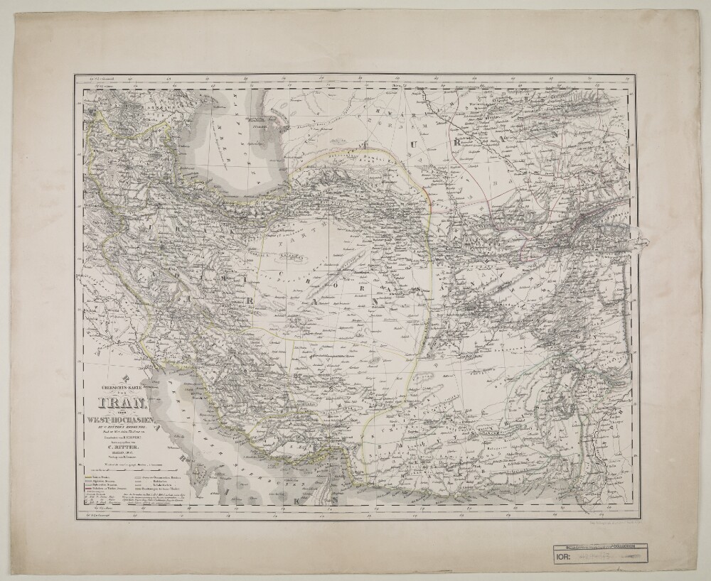
Abstract: Distinctive Features:Relief shown by hachures.Title continues: ‘Zu C. Ritter’s Erdkunde, Buch III, West-Asien, Theil VIII, IX. Bearbeitet von H. Kiepert, herausgegeben von C. Ritter. Berlin, 1852 Verlag von D. Reimer’.Map of Iran showing territorial extent of the Ottoman, the Russian and the British sphere of influence in the region with borders outlined in colour and explained in a key in the bottom left-hand corner below title. Also shows the boundaries between provinces and various routes across the region.Physical description: Dimensions:462 x 490 mm, on sheet 478 x 584 mm
Abstract: The volume contains lists of, and genealogical tables and biographies for, the notable families of Fars [Fārs] and Persian Officials at Shiraz [Shīrāz].The volume includes a 'Sketch Map of Boundaries of Districts of Fars', found in a pocket at the rear of the volume (folio 53).Physical description: Foliation: the foliation sequence (used for referencing) commences at the front cover with 1, and terminates at the inside back cover with 54; these numbers are written in pencil, are circled, and are located in the top right corner of the recto side of each folio. Pagination: the file also contains an original printed pagination sequence.
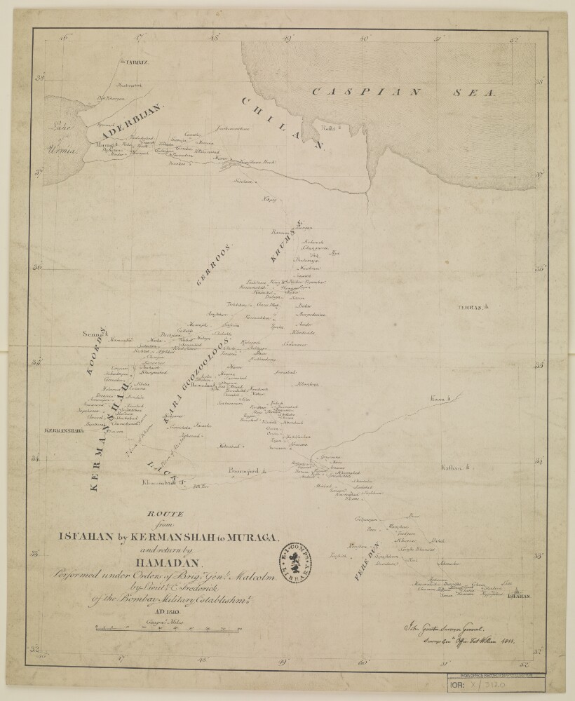
Abstract: Distinctive Features:Relief shown by hachures.Routes indicated by dotted lines.Inscriptions:On the recto in the bottom right-hand corner signature ‘John Garstin Surveyor Genls. Office Fort William 1811’.Labels:On the recto in the lower centre black ink oval stamp ‘E.I. COMP’S LIBRARY’.Physical description: Materials:Pen and ink on paperDimensions:501 x 400 mm, on sheet 545 x 450 mm
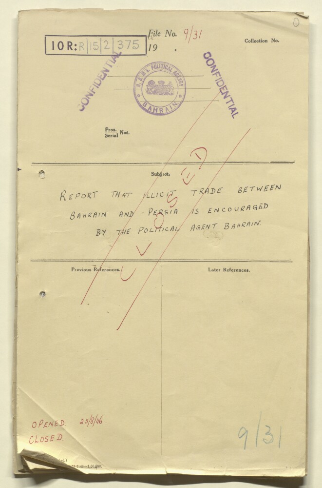
Abstract: The file contains correspondence between the Political Agent at Bahrain, the British Embassy at Tehran and the Adviser to the Government of Bahrain, concerning allegations of illegal trade between Bahrain and Iran by a merchant from Bushire, who was responsible for smuggling sugar, tea and opium into Bahrain, and who is believed to be employed by the Agency as an 'informer'.Physical description: Foliation: the main foliation sequence (used for referencing) commences at the front cover with 1, and terminates at the inside back cover with 18; these numbers are written in pencil, are circled, and are located in the top right corner of the recto side of each folio. An additional foliation sequence is present in parallel between ff 3-13; these numbers are also written in pencil, but are not circled, and are located in the same position as the main sequence. A previous foliation sequence, which is also circled, has been superseded and therefore crossed out.
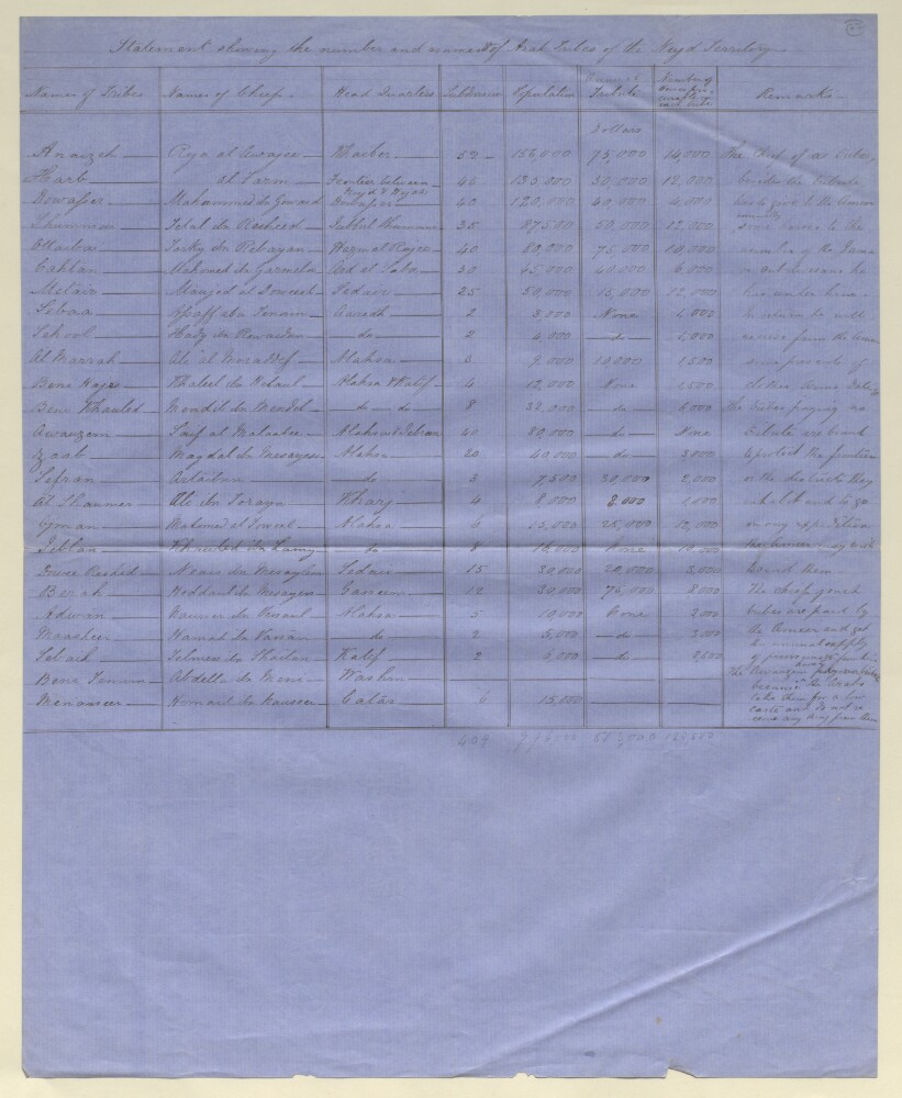
Abstract: The statement gives the following information for each tribe listed:Name of the tribeName of its ChiefIts place of headquartersNumber of subdivisionsPopulationAmount of tribute paid to Amir Faisul ibn Turki al-Sa'udNumber of horses procurable by each tribeRemarksThe remarks relate to the expectation that the Chief of each tribe would each year give horses to Amir Faisul. The amount of horses is determined by the number of Jama (subdivisions) the tribe had; in return the chief would receive clothes, weapons and dates from the Amir. A further remark notes that those tribes who pay no tribute are expected to protect the Nejd [Najd] frontiers and to go on any expeditions that the Amir wishes them to.Physical description: The folio has to be folded out in order to be read.
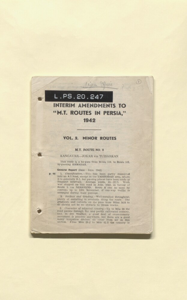
Abstract: The interim amendments are comprised of a list of routes through Persia compiled by the mechanical transport (M T). For each route the start and end destinations are given along with following: the total distance; references to maps showing the route; general notes and a report which breaks down the route into smaller parts; details of the route's suitability in various weather conditions; surface, gradient, character of adjacent country; climate, local features, condition of the roads, and available facilities and supplies such as camping locations and water.The routes described in the amendments are:M T Route No. 8 Kangavar [Kangāvar] - Jokar [Jowkār] via Tuisarkan [Tūyserkān]M T Route No. 9 Kangavar [Kangāvar] to mile 272 on route IV C via Nehavend [Nahāvand]M T Route No. 11 Hamadan [Ostān-e Hamadān] - Senneh [Sanandaj]M T Route No. 11-A Qurveh [Qorveh] - Sunqur [Sonqor] and thence to join route 1-B near Sahneh [Şaḩneh]M T Route No. 14 Hamadan [Ostān-e Hamadān] to Zenjan [Zanjān] via Kabutarahang [Kabūdarāhang]M T Route No. 16 Rawan [Ravān] to Saveh [Sāveh] via Nubaran [Nowbarān]M T Route No. 17 Saveh [Sāveh] to Tehran [Tehrān]M T Route No. 17-A Saveh [Sāveh] to Qum [Qom] via Kardin [Kūh-e Kordīn] and Haveh Āveh]M T Route No. 17-B Saveh [Sāveh] to Qum [Qom] via Anjilavand [Anjīlāvand]M T Route No. 32 Ahwaz [Ahvaz] to Ganaweh [Gonāveh] via Behbehan [Behbahān]M T Route No. 33 Behbehan [Behbahān] to Kazerun [Kāzerūn]M T Route No. 34 Bushire [Būshehr] to Ganoweh [Gonāveh]M T Route No. 42 Khumain [Khomeyn] to Isfahan [Isfahan] via Gulpaigan [Golpāyegān]M T Route No. 45 Nain [Nā’īn] to Qum [Qom] via Ardistan [Ardestān]M T Route No. 51 Bushire [Būshehr] - Lingeh [Lengeh]M T Route No. 55 Lar - Lingeh [Lengeh]M T Route No. 61 Lingeh [Lengeh] - Bandar Abbas Bandar ‘Abbās]M T Route No. 92 Meshed [Mashhad] - Sarakhs [Sarakhs]M T Route No. 93 Dughai [Dowghā’ī]- Sultanabad [Solţānābād]M T Route No. 94 Imam Quli [Emām Qolī] (Mile 122 on Route VIII-C) to Lutfabad [Loţfābād]M T Route No. 95 Quchan [Qūchān] - Bandar Shah [Bandar-e Torkaman]M T Route No. 98 Shahrud [Shāhrūd] - Shahpasand [Shāh Pasand]M T Route No. 101 Tehran [Tehrān] to Semnan [Semnān] via Aiwani-i-Kaif [Eyvānekey] and Garmsar [Garmsār]M T Route No. 102 Route 101, Mile 28.2, to Tehran [Tehrān] via Jalilabad [Jalīlābād] and Veramin [Varāmīn]M T Route No. 103 Rudian [Rūdehen] to Amol [Āmol] via Ab Ali [Āb‘alī]M T Route No. 104 Babul [Bābol] to Mahmudabad [Maḩmūdābād] via Amul [Āmol]M T Route No. 105 Arablar [Arablyar] to Maku [Mākū]Routes 8, 11, 42 and 101 also include appendices detailing alternative options to the principal route described.Physical description: Foliation: the foliation sequence commences at the front cover with 1, and terminates at the inside back cover with 48; these numbers are written in pencil, are circled, and are located in the top right corner of the recto side of each folio.
Abstract: The file contains correspondence and reports from the Government of India, External Department, the Foreign Office, the Secretary of State for India, the British Embassy at Tehran, the Minister of State in Cairo, the Ministry of Labour and National Service, and the British Consulates in Tabriz, Bandar Abbas, Zahidan [Zahedan, Iran], and Isfahan, on the subject of working conditions in Iran.The file also contains:a translation of the regulations drafted by the Iranian Ministry of Commerce & Industry (ff 95-97);details of arrangements for the welfare of workers, rates of pay, and cost of living figures for Iran in 1942;copies of the reports
Labour and industrial conditions in Farsand
Labour and trade union movements in Persia;extracts from
Iran,and
Journal de Tehran, in English and French.Physical description: Foliation: the foliation sequence commences at the front cover with 1 and terminates at the inside back cover with 109; these numbers are written in pencil, are circled, and are located in the top right corner of the recto side of each folio.
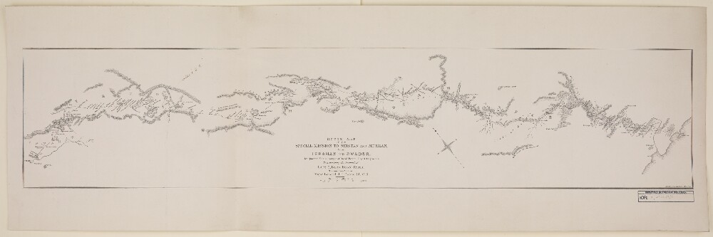
Abstract: Imprint:London, Trel. Saunders lith.Distinctive Features:Relief shown by hachures.Route of mission indicated in red line.Boundaries of provinces labelled and shown by pecked line.Original manuscript at IOR/X/3126/1.Physical description: Dimensions:193 x 945 mm, on sheet 317 x 994 mm
Abstract: Imprint:London, Trel. Saunders lith.Distinctive Features:Relief shown by hachures.Route of mission shown in line.Boundaries of provinces labelled and indicated by pecked line.Inscriptions:On recto correction in pen and ink to a place name ‘Sir-i-Yezd’ reads: ‘alter i to e’. Amended in print to ‘Ser-i-Yezd’, copy with amendment at IOR/X/3126/3/1.Original manuscript at IOR/X/3126/1.Physical description: Dimensions:193 x 945 mm, on sheet 315 x 989 mm
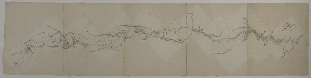
Abstract: Distinctive Features:Relief shown by hachures.Grid lines added in pencil between Kerman and Yezd (Yazd).Route of mission indicated in red line with sextan observations points shown by red dots. Boundaries of provinces coloured for reference.Reduced version of this map was lithographed and published in 1872 to accompany the Journal of Captain C. Bean Euan Smith. Printed copies at IOR/X/3126/3/1 and IOR/X/3126/3/2.Inscriptions:On recto across face of the map place names added in pencil.Physical description: Materials:Pen and ink with wash on paper with additions in pencilDimensions:656 x 2766 mm
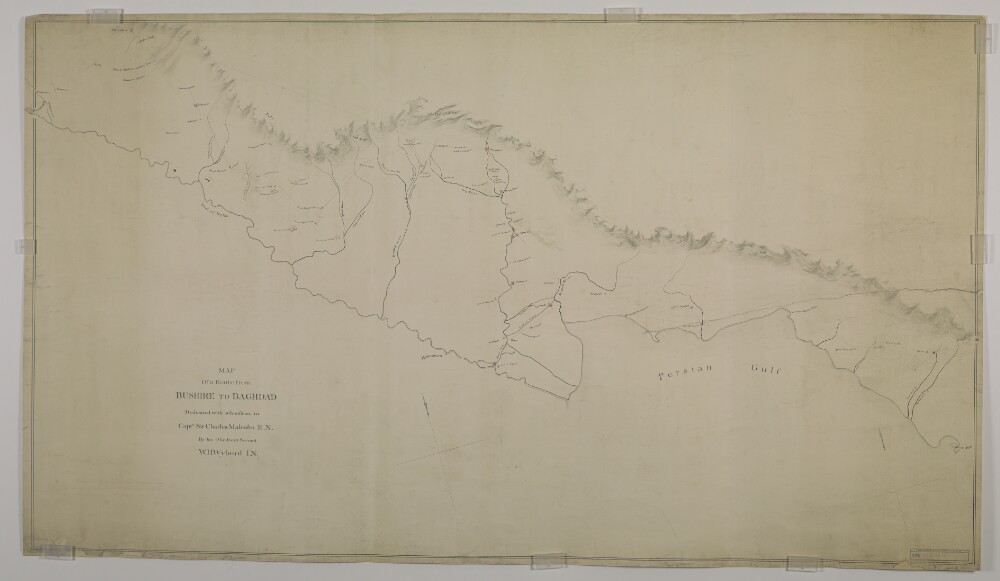
Abstract: Distinctive Features:Relief shown by hachures with grid lines added in pencil which do not feature on another copy of this map held at IOR/X/3122/1.Routes indicated by red lines.Places of interest including ruins, camps and mounds shown in red.Inscriptions:In the lower left-hand corner an annotation on the original map in red faded ink and partially illegible.Physical description: Materials:Pen and ink with grey wash on paperDimensions:735 x 1300 mm, on sheet 760 x 1300 mm
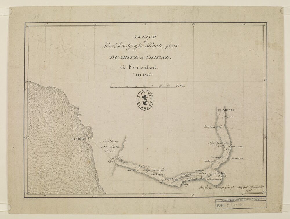
Abstract: Distinctive Features:Relief shown by shading.Route indicated by dotted line.Inscriptions:Signed in the bottom right-hand corner ‘John Garstin Surveyor General. Surveys. Genls Office Fort Willm. 1811.’Labels:On the recto in the centre black ink oval stamp ‘E.I. COMP’S LIBRARY’.Physical description: Materials:Pen and ink on paperDimensions:262 x 368 mm, on sheet 325 x 430 mm