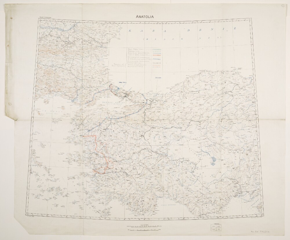
Abstract: Relates to the Treaty of Sèvres (1920)Created by the War Office August 1919 with boundaries added to 20 February 1920. Geographical Section, General Staff No. 2931, Sheet 'Anatolia'. Portrays hydrology, soundings, relief by spot heights and contours, railways, settlements, place names, and international and internal boundaries. Base map compiled from GSGS 2555 sheets NJ-35 (dated 1916), NJ-36 (1916), NK-35 (1919) and NK-36 (1916); projection information also derived from this source.Colour overprints, partly compiled from the information in folio 5, cover the Izmir (Smyrna) and Istambul [Istanbul] areas of western Turkey and depict boundaries of Vilayets, Sanjaks and Kazas; General Milne's Line; Line of Paris Greek Commission; Line of London Smyrna Commission; Line showing Greek claim of 19 February 1920; Line of Turkish Demilitarized Zone [Zone of the Straits]; and percentages of Races for complete Kazas, together with a list of Kazas.Verso bears the annotation 'Dardanelles'.Physical description: Materials: Printed in colour, with manuscript additions in pencilDimensions: 595 x 722mm, on sheet 713 x 830mm
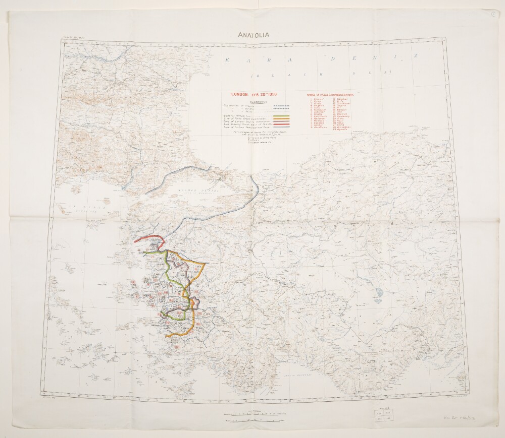
Abstract: Relates to the Treaty of Sèvres (1920).Created by the War Office August 1919 with boundaries and proposed boundaries added to 30 March 1920. Geographical Section, General Staff No. 2931, Sheet 'Anatolia'. Portrays hydrology, soundings, relief by spot heights and contours, railways, settlements, place names, and international and internal boundaries. Base map compiled from GSGS 2555 sheets NJ-35 (dated 1916), NJ-36 (1916), NK-35 (1919) and NK-36 (1916); projection information also derived from this source.Manuscript additions cover the Izmir (Smyrna) and Istambul [Istanbul] areas of western Turkey and depict the Enos-Midia Line; the Chatalja Line; the Zone to be demilitarised [Zone of the Straits]; the Line of Greek occupation; the W[ar]O[ffice] proposal for modification of demilitarised zone (11th March); the W[ar]O[ffice] proposal for Turko-Greek frontier (30 March 1920); the Turko-Greek frontier (as decided by Peace Conference); and the Neutralised Zone (as decided by Peace Conference). A small number of other features are also highlighted.Physical description: Materials: Printed in colour, with manuscript additions in pencil, crayon and coloured ink, on paperDimensions: 595 x 722mm, on sheet 713 x 860mm
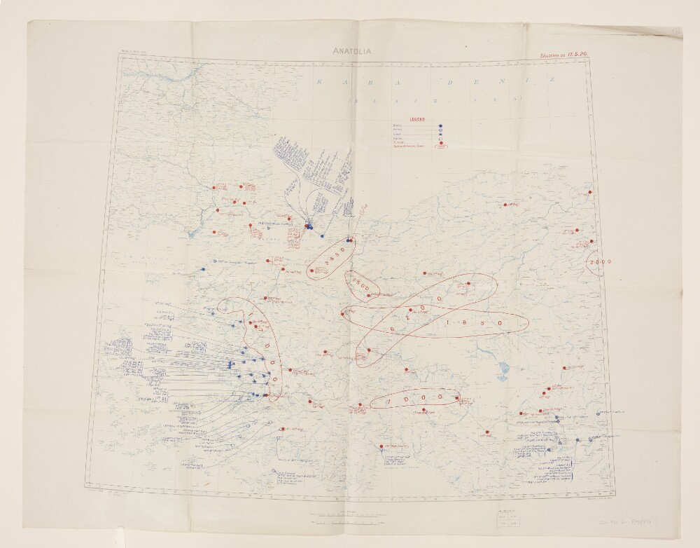
Abstract: Folio 7:Geographical Section, General Staff No. 2931, sheet 'Anatolia', comprising a base map with overprints.The base map bears the imprint 'War Office, November, 1919' and portrays hydrology, relief by spot heights, railways, settlements, place names, and internal and international boundaries. A contoured version of this base map is at Maps 47100.(24.).A blue overprint depicts the position of British, French, Greek and Italian troops as at 17 May 1920; a red overprint depicts the position of Turkish troops and Turkish Nationalist Bands.Folio 7a:Typescript note attached to the verso of Folio 7 reading:'Mr. Leigh. Sir John Tilley thinks Lord Curzon might like to see these Maps showing the present Military situation in Turkey. [Signed] ? C.S. Heather ? la Smith 3 June, 1920.'Typescript, with manuscript additions in ink. 210 x 84mm.Physical description: Materials: Printed in colourDimensions: 594 x 725mm, on sheet 709 x 913mm
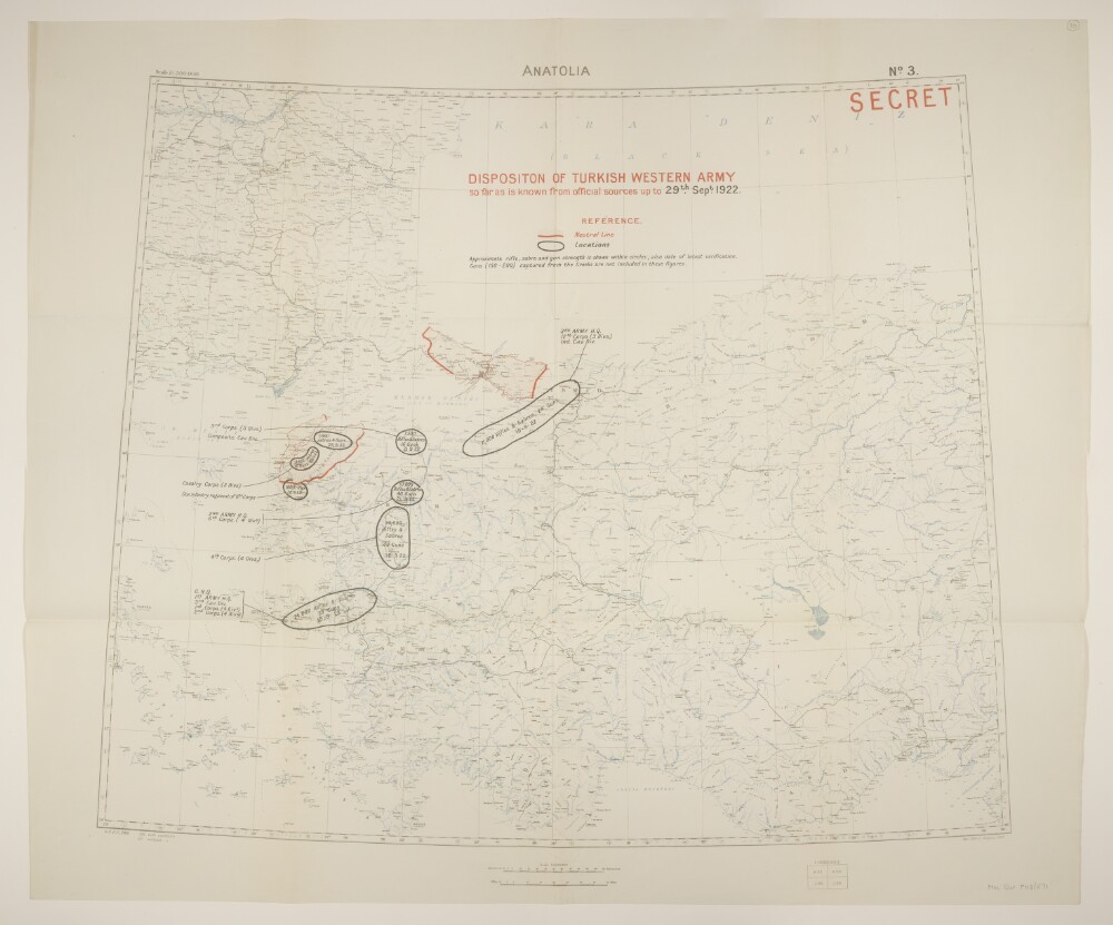
Abstract: Geographical Section, General Staff No. 2931, sheet 'Anatolia', comprising a base map with overprints.The base map bears the imprint 'War Office, August, 1919' and portrays hydrology, relief by spot heights, railways, settlements, place names, and internal and international boundaries. A contoured version of this base map is at Maps 47100.(24.).A red overprint depicts Neutral Lines and bears the classification 'Secret'. A black overprint depicts the position of the Turkish Western Army, including the fighting strength at various locations; the sheet is numbered 'No. 3.'Physical description: Materials: Printed in colourDimensions: 594 x 725mm, on sheet 709 x 848mm