« Previous |
1 - 12 of 69
|
Next »
Number of results to display per page
Search Results
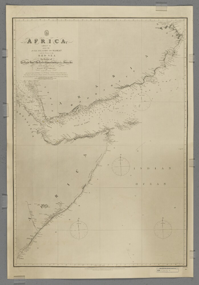
1. 'Africa, Sheet VI from the Juba Islands to Maskat with the Entrance to the Red Sea'
- Description:
- Abstract: Chart 598.Hydrographic chart covering the Horn of Africa north of the Juba [Bajun] Islands, the southern coast of the Arabian Peninsula to Maskat [Muscat], the western Indian Ocean, the Gulf of Aden and the southern Red Sea. Portrays hydrology, including depths by soundings and some contours, sands and rocks, relief by hachures and occasional spot heights, settlements and place names, and includes topographical notes and navigational aids, including lights highlighted in watercolour.Chart compiled under the direction of Captain William Fitzwilliam Owen from 1822 to 1826, assisted by Captain Alexander Thomas Emeric Vidal and lieutenants William Mudge, Thomas Boteler, Richard Owen, Edward Owen Johnes and Messrs Rogier, Arlett, Durnford, Badgley, Robinson, Bowen and Mercer, Midshipmen. North of 10°N the chart is compiled from reductions of more recent surveys by 'the East India Company's Officers'. Engraved by J & C Walker. Published by the Admiralty 1827, with corrections 1868, 1873, 1875, November 1876, December 1876, May 1877 and September 1877.Physical description: Materials: Printed, with watercolour additions, on paperDimensions: 870 x 600mm, on sheet 982 x 669mm
2. 'Papers relating to Seas, Rivers and Countries connected with Steam Navigation in Asia'
- Description:
- Abstract: Volume containing journals and other descriptions of journeys in and around the Arabian Peninsula and India, particularly sea and river journeys. The volume contains:‘Captain Wainwright's Remarks on the Navigation of the Persian Gulph 1809-1810’ (folios 3-28), containing a description of the navigation of the Gulf and the ports, anchorages and other notable places along its coastline, written by Captain John Wainwright of the East India Company ship Chiffonne‘Captain Sadlier's Diary of his Mission to Arabia 1819-20’ (folios 29-192), containing a description of an expedition across Arabia by Captain George Forster Sadlier to deliver a confidential message from the Government of Bombay to Ibrahim Pacha, commander of the Egyptian forces in the Wahhabi War (also known as the Ottoman-Saudi War). The message to Ibrahim, offering military support to future Ottoman actions against the Wahabees [Saudis] and Joasmee [Al-Qasimi], is included on folios 37-40. A letter containing instructions to Sadlier is on folios 33-37. Folios 40-61 describe Sadlier’s journey from Bombay [Mumbai] to Bushire, April-June 1819, calling at Muscat in May to inform the Imam of his mission. Sadlier’s journey from Kuteef [Qatif, also written as Katief and Katuffe] to Yambo [Yanbu] is described in brief on folios 29-33. The same journey, Sadlier’s interactions with Ibrahim, and his return journey as far as Jeddah are described in detail on folios 61-190‘Captain Bedford's Journals of the Survey of the Burrampooter River - 1824 & 1825’ (folios 193-304), containing a description by Captain James Bedford of a survey of the Burhampooter [Brahmaputra] River, also called the Dihung [Dihang] River. A small sketch map of part of the river is included on folio 260. Folios 303-304 contain a brief vocabulary of the Mismee [Mishmi] language‘Captain Bonamy's Memoranda on the North West Frontier of British India and of the importance of the River Indus as connected with it's [sic] defence 1830’ (folios 305-383), containing a description of the area and notes on the defence of British India against a theoretical invasion by Russia‘Lieutenant Welsted's Memoir regarding the Red Sea and Steam Navigation between Europe & India 1832’ (folios 384-497), containing a description of the navigation of the Red Sea and the ports, anchorages and other notable places along the coastline, written by Lieutenant James Raymond Wellsted [written as Welsted or Welstead] of the East India Company ship Palinurus, as part of a survey under the command of Captain Thomas Elwon of the East India Company ship Benares. A description of the ‘inhabitants to the Northward of Juddah’ [Jeddah] is included on folios 460-473‘Lieutenant Wybard's Journal of an Excursion into Arabia 1832’ (folios 497-534), containing a description of a journey into Arabia by Lieutenant J W Wybard in September-December 1832. Folios 499-509 contain Wybard’s journal describing his journey from Bushire to Bussora [Basra] on the East India Company ship William IV, from Bussora to Bahrein [Bahrain] and then to Ajeer [Uqair] on various Arabian vessels, overland from Ajeer to Ehiasa [Hofuf], and an aborted attempt to reach Readth [Riyadh] before returning by the same route. Folios 509-513 contain descriptions of Ehiasa and Bahrein. Folios 517-532 contain a description of ‘the Arab Tribes on the Banks of the Euphrates and Tigris’. Folios 533-534 contain ‘A Map of the Oases of El Hasa’ [El Ahsa] [IOR/L/MAR/C/587, ff 533v-534].Physical description: Foliation: the foliation sequence (used for referencing) commences at the first folio with 1 and terminates at the inside back cover with 538; these numbers are written in pencil, are circled, and are located in the top right corner of the recto side of each folio.An additional foliation sequence is present in parallel between ff 193-534; these numbers are also written in pencil, but are not circled.The foliation sequence does not include the front cover, nor does it include the leading flyleaves.

3. 'Proceedings of Captain Chiefalla, of the Greek Privateer "Hellas" – Proclamation issued, forbidding British subjects from serving under any foreign flag against the Turks in India or the Red Sea'
- Description:
- Abstract: The item consists of copies and extracts of correspondence, minutes and resolutions cited in, or enclosed with, letters from the Government of Bombay and the Government of Bengal. The item is chiefly concerned with proceedings against Captain Nicolo Chiefala of the Greek vessel Hellas, who is suspected of carrying out 'piratical' acts in the Red Sea by detaining and plundering several vessels which were under multiple foreign flags. In particular, the item relates to:Enquiries, mostly at Mocha and Bombay, into Chiefala's activities by a committee composed of the Superintendent of Marine, the Advocate General and the Senior Magistrate of PoliceEnquiries into claims that British subjects were employed on the Hellasand that multiple English vessels provided assistance and provisions to her, including the English ship Trois FrèresChiefala's claims that he had appropriate authorisations from the Greek and Mauritius Governments to purchase and arm a vessel for the purpose of molesting ships under Turkish control in the Red SeaAccounts and petitions from individuals whose ships were detained by Chiefala and individuals associated with the Hellas, such as the Commander of the Trois FrèresThe Government of Bombay's correspondence with multiple Governments in the Red Sea requesting further information and assistance in detaining Chiefala and his associates, Sailing Captain Samuel Lingard and Lieutenant DenhamA proclamation by the Government of Bombay forbidding British subjects from serving under foreign flags who intend to attack Turkish vessels; the Advocate General's opinions on the legality of this proclamation as well as the authority of the Government to make such a proclamation.Correspondents include: Governments of Bombay, Bengal and Madras; Sir Charles Malcolm, Superintendent of the Marine, Bombay; Anthony Hammond, Advocate General, Bombay; J D Devitre [James D De Vitre], Senior Magistrate of Police; the Governments of Goa, Mocha, Mauritius and Demaum [Ad-Dammān]; the Imaum [Imam] of Senna [Sana'a]; Residents at Cutch [Kutch], Mocha and in the Persian Gulf; the Native Agent at Mocha; Jean-François Hodoul, Commander of the Trois Frères.The title page of the item contains the following references: 'Bombay Political Department No. 4', 'P.C. 980, Draft. 38. 1832' and 'Examiner's Offi-'.Physical description: Foliation: the foliation sequence for this description (used for referencing) commences at f 4, and terminates at f 157, as it is part of a larger physical volume; these numbers are written in pencil, are circled, and are located in the bottom right corner of the recto side of each folio.Pagination: the volume also contains an original pagination sequence.
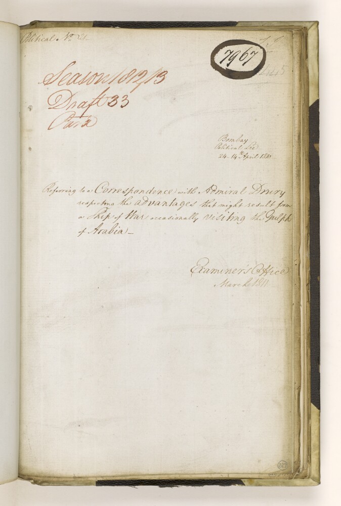
4. 'Referring to a Correspondence with Admiral Drury respecting the advantages that might result from a Ship of War occasionally visiting the Gulph of Arabia'
- Description:
- Abstract: The item consists of correspondence between the Government of Bombay and Rear Admiral William O’Brien Drury, Commander-in-Chief, East Indies Station, regarding a proposal for increased British naval presence in the Gulf of Arabia [Red Sea] in order to resist French influence in the region.Physical description: Foliation: the foliation sequence for this description (used for referencing) commences at f 287, and terminates at f 294, as it is part of a larger physical volume; these numbers are written in pencil, are circled, and are located in the bottom right corner of the recto side of each folio.Pagination: the item also contains an original printed pagination sequence.
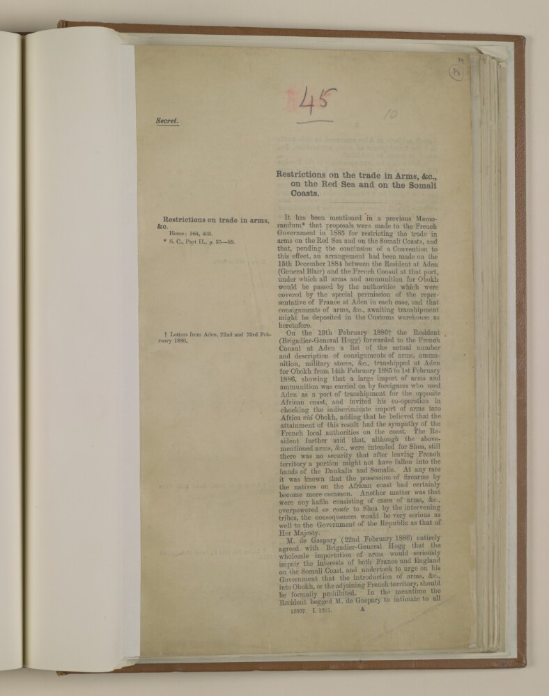
5. 'Restrictions on the trade in arms, &c., on the Red Sea and on the Somali Coasts'
- Description:
- Abstract: The file consists of a memorandum by Edmund Neel, Assistant Secretary Political and Secret Department, India Office, it describes proposals made to the French Government for restricting the trade in arms on the Red Sea and on the Somali Coast, and subsequent arrangements to effect them between the Political Resident and the French Consul at Aden.The file includes a series of extracts from letters by the Political Resident at Aden, discussing draft regulations prohibiting the export of arms into Obokh and adjoining French territory for recommendation to the French Government, and deals with the confusion as to whether to restrict or suppress the arms trade entirely. It includes a 'Draft Convention' and 'Draft Order in Council' from 1887.Physical description: Foliation: the foliation sequence for this description commences at f 78, and terminates at f 81, as it is part of a larger physical volume; these numbers are written in pencil, are circled, and are located in the top right corner of the recto side of each folio. An additional foliation sequence is present in parallel between ff 78-81; these numbers are also written in pencil, but are not circled.
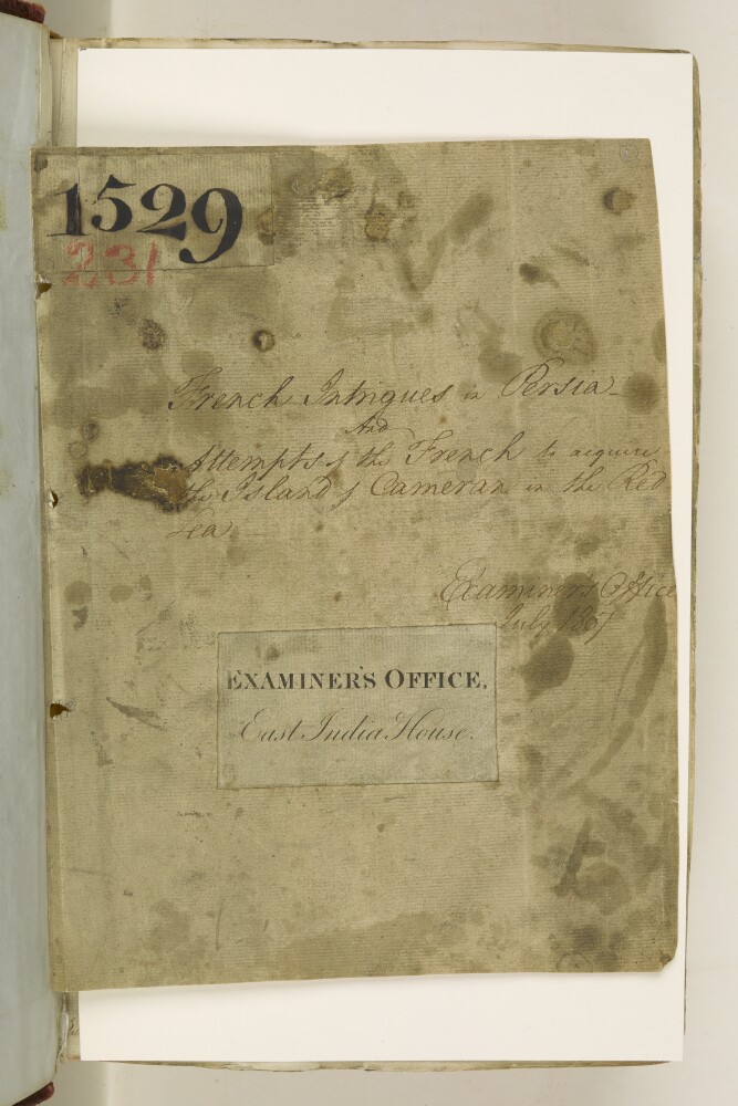
6. 'French intrigues in Persia and Attempts of the French to acquire the Island of Cameran in the Red Sea'
- Description:
- Abstract: The item consists of correspondence and extracts of papers relating to French influence and activities in the Red Sea (often referred to as the ‘Arabian Gulph’) and Persia [Iran], sent to the Chairman of the Court of Directors, Charles Grant, and the Secret Committee.Matters covered include:French efforts to establish a trading and military settlement on the island of Cameran [Kamaran] through the agency of Syed Mahomed Akil [Sayyid Muḥammad ‘Aqīl]The preparations for and progress of an expedition to the Red Sea to counter French activitiesThe plunder and destruction of the American ship Essexby Syed Mahomed Akil and his followersDiscussion of the legality of seizing Syed Mahomed Akil and his shipsAntoine-Alexandre Romieu’s mission to the Court of Persia as an agent of FranceFrench influence in Persia, Bagdad [Baghdad], and AleppoThe impact of any agreement reached between France and Persia on Anglo-Persian relationsA second French embassy to the Court of Persia following Romieu’s death in TehranHajee Mohsen’s [Ḥājī Muḥsin] deputation to Tehran to gather intelligence on French activities and to try and counter their influenceThe proposal of Sir Harford Jones, Resident at Bagdad, that he travel to Persia as British EnvoyThe dispatch of a Persian Embassy to FranceHostilities between Russia and Persia along the latter’s northern frontier.Correspondence regarding the Red Sea comes from the following: the Government of Bombay; Sir Edward Pellew, Commander-in-Chief, East Indies Station; the Government of Bengal; Lieutenant Charles Court, Commander of the Panther, at Mocha; the Government of Madras; Searkrun/Searkum Kirjee, East India Company Broker at Mocha.Correspondence regarding matters in Persia comes from the following: Samuel Manesty, Resident at Bussorah [Basra]; John Barker, Consul General at Aleppo; Harford Jones, Resident at Bagdad, and John Hine, Acting Resident at Bagdad; William Bruce, Acting Resident at Bushire [Bushehr]; Alexander Stratton, Ambassador at Constantinople; Leopold Sebastiani, Prefect of the Catholic Mission in Ispahan [Isfahan]; and Lord Viscount Castlereagh, First Commissioner for the Affairs of India.Physical description: The papers are arranged in rough chronological order, from the left to the right.
7. ‘Slave Trade – Carried on between Abyssinia & the different Ports in the Red Sea.’
- Description:
- Abstract: The item consists of copies and extracts of correspondence enclosed within letters from the Government of Bombay [Mumbai], the India Board, and the Foreign Office. The item relates to:Suggestions by the above correspondents for suppressing the trade in enslaved people from the coasts of Abyssinia [Ethiopia] and Burbarra [Berbera] to the [other] ports in the Red SeaInformation supplied by Stafford Bettesworth Haines, Political Agent at Aden, in which he outlines Massowah [Massawa], Sauken [Sawākin], Tedjaura [Tadjourah], Zeyla [Saylac], and Burbarra as the principal ports in the Red Sea involved in the trade in enslaved people and provides his opinion on whether the rulers of these ports could be persuaded to abandon the trade (folios 198-200)A report by Commander Denton, Senior Naval Officer in the Red Sea, with the results of his enquiry into the allegation that Mallim Yousef Yacoob [Mu‘allim Yūsuf Yaʿqūb], Government Agent at Judda [Jeddah], and Hassain Effendi [Hasan Efendi], former Governor of Massowah, had sold enslaved people to a number of French men (folios 201 verso to 202 recto)A report by Commander A H Nott which provides details on the main ‘articles of export’ from the port of Massowah, namely: enslaved people; musk; ivory; ghee; gum; and hides. Particular attention is paid to where the enslaved people come from, how they are acquired, how much tax is levied for each individual, and the fact that many of them are Abyssinian Christians.Nott's report also provides brief details on the ‘annual yield’ of Dahlad Island [Dahlak Kebr] as well as the current political statuses of the ‘State of Abyssinia’ and Gondar [Gonder]. It can be found at folios 205-212.In addition to the above correspondents, the item includes correspondence from Rear Admiral Sir Charles Malcolm, Superintendent of the Indian Navy.The title page of the item contains the following references: ‘Bombay Political Department’, ‘P.C. [Previous Communication] 3228, Draft 714, 1841’, ‘Collection No. 4 of No. 34’ and ‘Examiner’s Office’.Physical description: Foliation: the foliation sequence for this description (used for referencing) commences at f 193, and terminates at f 213, as it is part of a larger physical volume; these numbers are written in pencil, are circled, and are located in the bottom right corner of the recto side of each folio.Pagination: the item also contains an original pagination sequence.
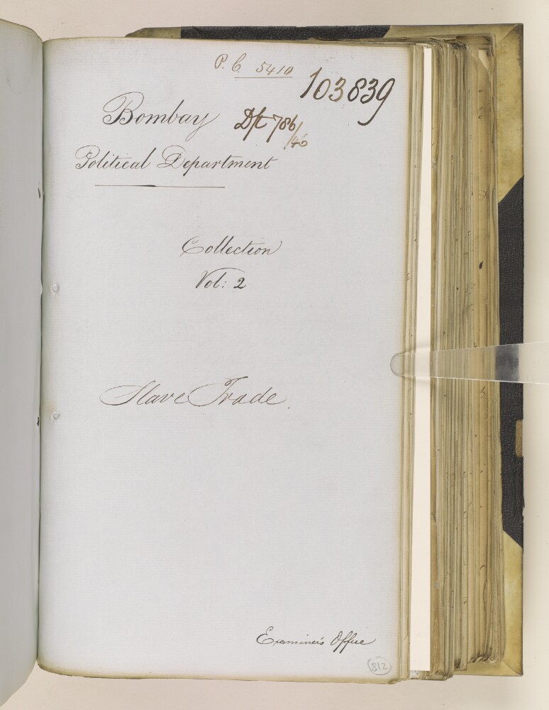
8. 'Slave Trade'
- Description:
- Abstract: The item consists of copies and extracts of correspondence, minutes and resolutions which are most likely to be the enclosures to extract Political Letters from the Government of Bombay [Mumbai] to the East India Company Court of Directors, dated 1 December 1845 and 31 December 1845, copies of which can be found at IOR/F/4/2157/103838.The item relates to an agreement reached between Her Majesty the Queen of the United Kingdom of Great Britain and Ireland and His Highness Said Saeid bin Sultan, Imaum of Muskat [Sayyid Sa‘īd bin Sulṭān Āl Bū Sa‘īd, Imam of Muscat, also referred to as the Sultan of Muscat] on 2 October 1845. The agreement relates to the suppression of the ‘slave trade’ [trade in enslaved people]. The item’s correspondents include: the Imaum; Captain Atkins Hamerton, HM Consul and the Company’s Agent in the Dominions of the Imaum of Muskat; and the governments of Bombay and India.In particular, the contents relate to:The different articles of the agreementDifferences in the translations of the agreementHamerton’s report to the Earl of Aberdeen, George Hamilton-Gordon, Secretary of State for Foreign Affairs, providing details on his discussions with the Imaum in relation to the agreementAdditional articles suggested by the Imaum.Enclosures to the correspondence include: a copy of the agreement in English (ff 816-817); a copy of the agreement in both English and Arabic (ff 820-822); and a copy of the additional articles proposed by the Imaum in both English and Arabic (f 840).The title page of the item contains the following references: ‘Bombay Political Department’, ‘P.C. [Previous Communication] 5410, Draft 786/46’, ‘Collection Vol: 2’ and ‘Examiner’s Office’.Physical description: Foliation: the foliation sequence for this description (used for referencing) commences at f 812, and terminates at f 841, as it is part of a larger physical volume; these numbers are written in pencil, are circled, and are located in the bottom right corner of the recto side of each folio.Pagination: the item also contains an original pagination sequence.
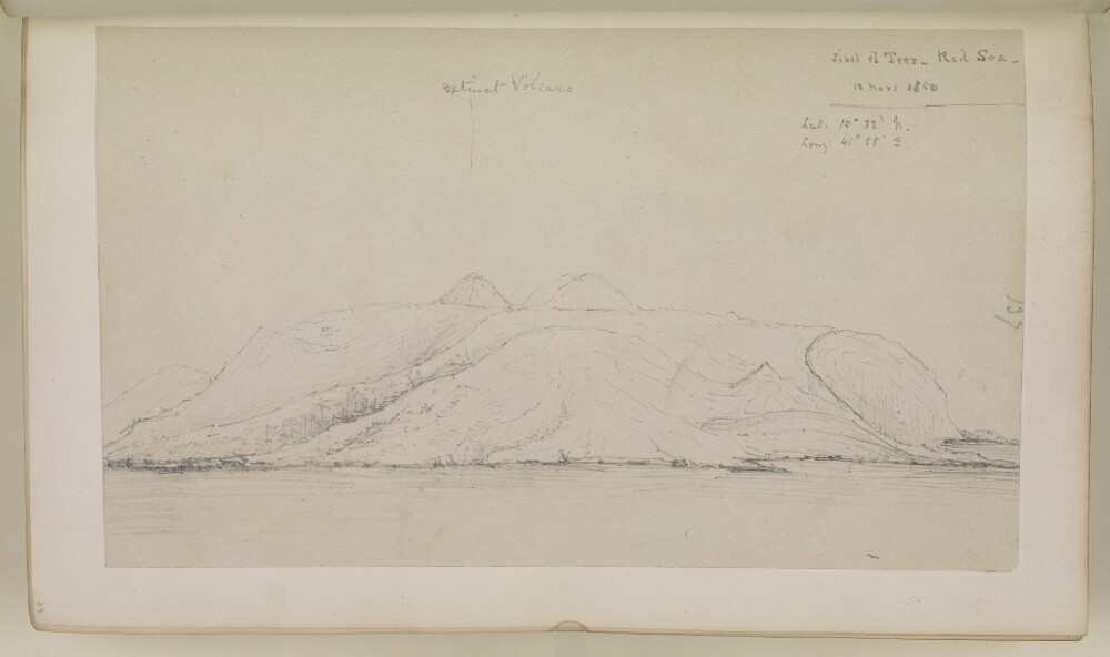
9. ‘Jibel el Teer – Red Sea. 13 Novr 1850’
- Description:
- Abstract: Genre/Subject MatterPencil sketch on paper.The sketch shows a maritime / topographical view of Jibel el Teer (Jabal al-Tair Island), a roughly oval-shaped volcanic island northwest of the Bab el-Mandab strait in the Red Sea.Two raised peaks are illustrated at the centre of the island, while the right of the island a curved cliff face appears to drop towards the sea.InscriptionsRecto, in pencil:Right edge: ‘137’Upper right corner: ‘Jibel el Teer – Red Sea. 13 Novr 1850’ ‘Lat: 15º 32’ N. Long: 41º55’ E.’Upper centre: ‘extinct Volcano’Temporal contextThis sketch is part of a series of six drawings over consecutive days, 11–13 November 1850, during the journey between Aden and the Red Sea.Physical description: Dimensions:165 x 280 mm [landscape]Format:Pencil sketch on paper, pasted into volumeCondition:The sketch is in good condition with surface residue throughout.Foliation:On paper: ‘137’On mounting paper ‘34’
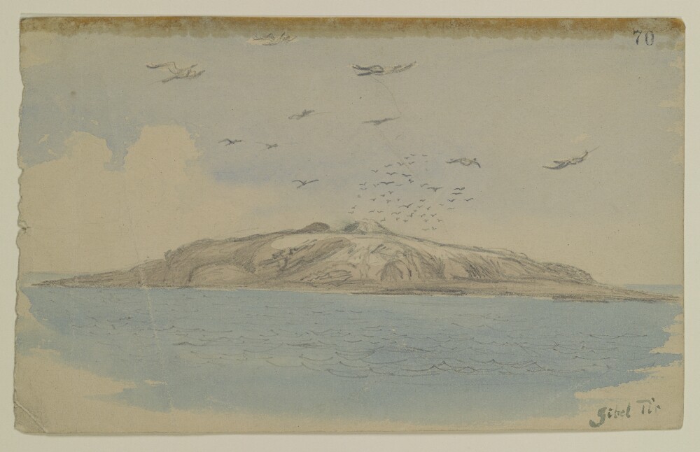
10. 'Gibel Tir', by Sir Henry Yule (1820-1899)
- Description:
- Abstract: Genre/Subject Matter:Maritime view in the Red Sea, at the northwest of the Bab el-Mandeb strait, of Gibel Tir [Jebel Al-Tair], meaning ‘bird mountain’.Temporal context:This drawing was likely made during Henry Yule’s return journey to India with his new wife, Anna Maria White, in 1844.Inscriptions:Recto:Lower right, pen and ink: ‘Gibel Tir’Upper right, ink stamp: ‘70’Verso:Centre, ink stamp: ‘India Office Library 12 Dec 1919’Upper left, pencil: ‘37’Physical description: Dimensions:140 x 226 mmMaterials:Watercolour and pencil on watercolour paperCondition:Thick surface dirt throughout and on recto with staining originating from adhesive on upper edge.
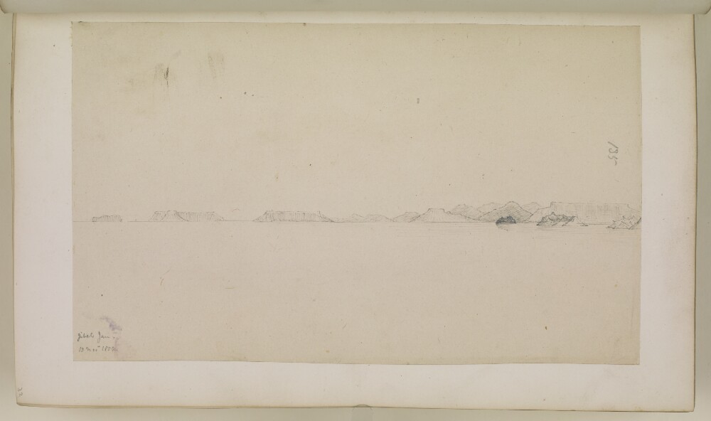
11. ‘Jibel Jan – 13 Novr 1850.’
- Description:
- Abstract: Genre/Subject MatterPencil sketch on paper.The sketch shows a maritime / topographical view of Jibel Jan, which is likely to refer to Djebel Jan on the coast of latter-day Djibouti.The view was sketched from on board ship and shows a series of flat-topped islands leading away from the coastline on the right of the horizon.InscriptionsRecto, in pencil:Right edge: ‘135’Lower left corner: ‘Jibel Jan – 13 Novr 1850.’Temporal contextThis sketch is part of a series of six drawings over consecutive days, 11–13 November 1850, during the journey between Aden and the Red Sea.Physical description: Dimensions:162 x 270 mm [landscape]Format:Pencil sketch on paper, pasted into volumeCondition:The sketch is in good condition with scuffing in the upper right as well as some dark spot staining throughout and a purple stain in the lower left corner.Foliation:On paper: ‘135’On mounting paper ‘32’
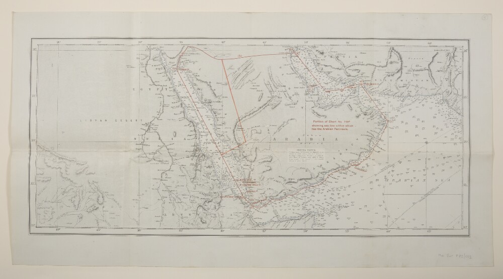
12. 'Portion of Chart No. 748B showing sea line within which lies the Arabian Peninsula.'
- Description:
- Abstract: Covers the Persian Gulf, Gulf of Aden and Red Sea, including hinterlands to a width of approximately 150 miles beyond which detail diminishes. Comprises a base map, overprint and manuscript additions.The base map is produced from British Admiralty Chart No. 748B titled 'Indian Ocean - Northern Portion' dated 15 November 1918 and filed at Maps B.A.C. (748B.). Portrays marine hydrology, including sands, rocks and depths by soundings, inland hydrology, relief by hachures and spot heights, railways, roads and tracks, settlements and place names. Bears the notes 'Drawn for engraving by E J Powell' and 'Engraved by Davies Bryer & Co.'A red overprint portrays the sea line including geographical reference points, some of which possess reference letters although no key is present.Manuscript additions relate to the sea line and also accentuate the coastline.The verso bears the annotation 'Arabia'.Physical description: Materials: Printed in colour, with manuscript additions in crayonDimensions: 290 x 676mm, on sheet 405 x 763mm