Abstract: Intelligence report by Major Norman Napier Evelyn Bray, Political Intelligence Officer attached to the India Office, on Soviet activities and influence in the Middle East and the implications for British interests in the region.The document was prepared as a departmental minute. It discusses several matters, including: the Soviet alliance with Turkish and Arab nationalists across the region, but with a particular reference to Mesopotamia; Italian support (in money and arms) of Turkish nationalists; the need for the British and the French to work together closely to protect their interests; the military strength of all parties.The report contains two appendices, as follows:I - Suggested measures for dealing with the Bolshevist Menace in Mesopotamia and Persia;II - A. Conditions proposed by the Bolsheviks for acceptance of Turkish Nationalists; B. Terms of agreement concluded by Bolsheviks with Mustafa Kemal Pasha.There are extensive notes in the left hand margin throughout the report with details on sources and other comments.Physical description: Foliation: the sequence commences at the first folio and terminates at the last folio; these numbers are written in pencil, are circled, and are located in the top right corner of the recto side of each folio. A second foliation sequence is also present in parallel between ff 3-15; this sequence is written in ink, and is located in the same position as the main sequence.
Abstract: This printed memorandum, by Joseph Austen Chamberlain, contains a report of a lecture 'Germany and the Middle East', by Dr Paul Rohrbach given at the Hamberg Volksheim which was printed in
Hamburger Fremdenblatt, 3 December 1915.The report discusses Rohrbach's opinions on the current situation in Europe and how Germany now had an advantage following the opening up of routes to the Middle East and the Suez Canal through the provision of railways and money to Turkey. The lecture also focused on Germany's need for raw materials, how access to the Middle East can provide them with oil, minerals, cotton and wheat, and the potential future economic benefits posed by the war-time alliance of Germany, Austria-Hungary, Bulgaria and Turkey. The lecture concludes with the suggestion that as Germany cannot compete with Britain in its Naval strength it could use the Suez Canal as a point of pressure to try to secure access to the sea and its own position in the heart of Europe.Physical description: Foliation: The foliation commences and concludes on folio 6, as it is part of a larger physical volume. These numbers are written in pencil, are circled, and are located in the top right corner of the recto side of each folio. An additional former foliation sequence is also present in the volume; these numbers are also written in pencil, are not circled, and can be found in the same position as the main sequence.
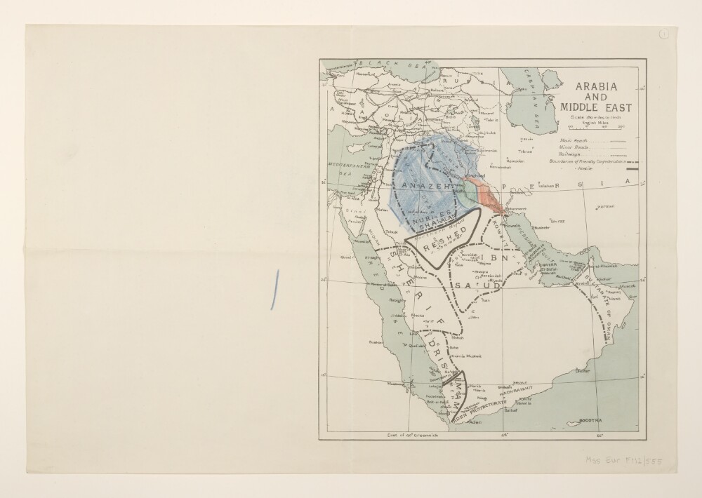
Abstract: Covers the Arabian Peninsula and Middle East. Portrays hydrology, railways, roads, settlements, place names and, within the Arabian Peninsula, the boundaries and names of 'friendly' and 'hostile' confederations. Manuscript additions show unreferenced supplementary shaded areas.Creation date derived from railway information and date of Arab Revolt.Verso bears the annotation 'Arabia & Mesopotamia'.Other copies of the printed map are filed at Mss Eur F112/552, ff 3-4; a similar manuscript map is at Mss Eur F112/552, f 10.Physical description: Materials: Printed in colour, with manuscript additions in crayonDimensions: 306 x 262mm, on sheet 369 x 536mm
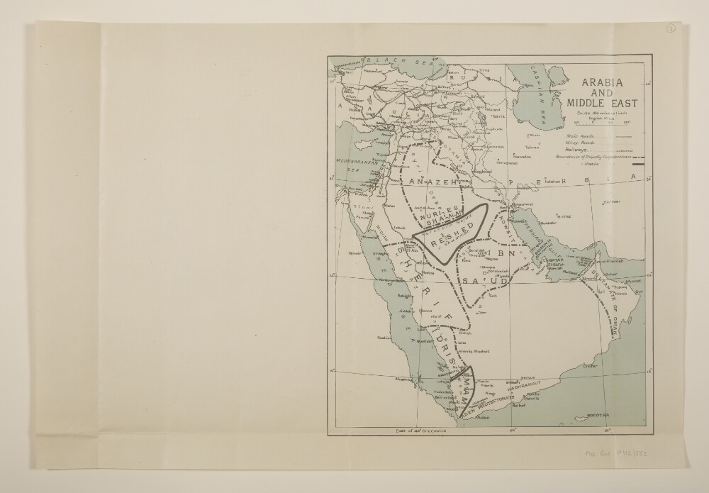
Abstract: Two identical map sheets covering the Arabian Peninsula and Middle East. Sheets portray hydrology, railways, roads, settlements, place names and, within the Arabian Peninsula, the boundaries and names of 'friendly' and 'hostile' confederations. (Another copy at Mss Eur F112/555, f 1 and Mss Eur F112/552, f 10 which portrays similar information in manuscript.)Creation date derived from railway information and date of Arab Revolt.Folio 3 bears the annotation 'Red Sea Arabia' on the verso; folio 4 bears pencil additions in the margin and the annotation 'Arabia' on the verso.Physical description: Materials: Printed in colour, with manuscript additions in pencilDimensions: 306 x 262mm, on sheet 369 x 536mm
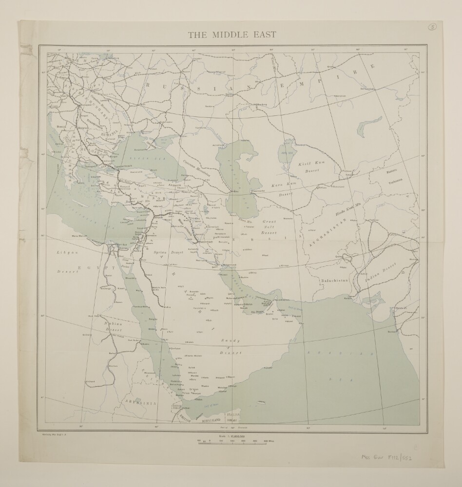
Abstract: Published by 'Admiralty War Staff I[ntelligence].D[ivision].' Covers the Middle East and south-west Asia. Printed map sheet portrays hydrology, railways, settlements, place names and international boundaries.Creation date derived from railway information.Verso bears the manuscript annotation 'Middle East'.Physical description: Materials: Printed in colourDimensions: 358 x 360mm, on sheet 431 x 408mm
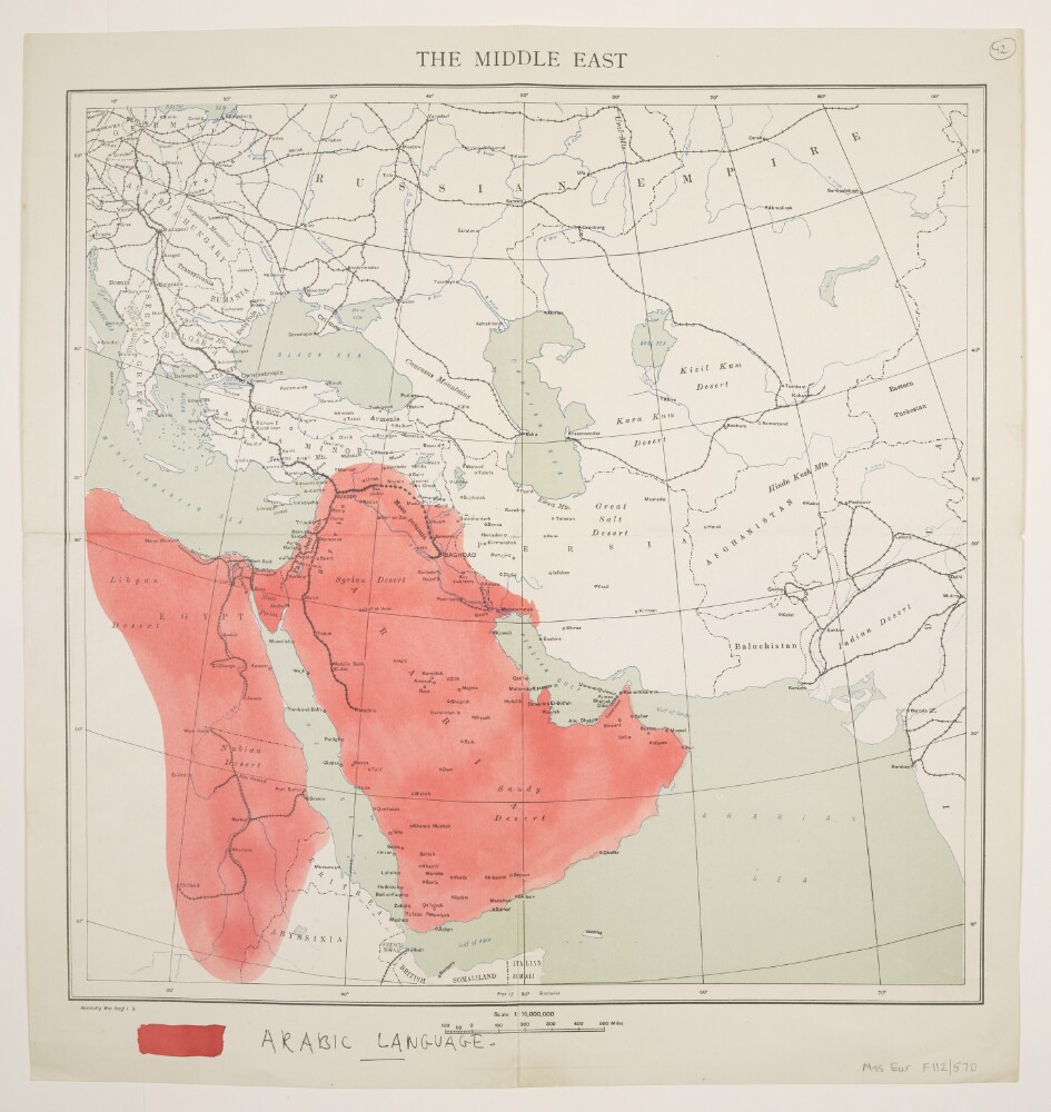
Abstract: Published by 'Admiralty War Staff I[ntelligence].D[ivision].' Covers the Middle East and south-west Asia. Printed map sheet portrays hydrology, railways, settlements, place names and international boundaries. A watercolour wash has been added to show Arabic language areas.Creation date derived from railway information and extent of British control and political interest as depicted on Mss Eur F112/570, f 43.Verso bears the manuscript annotation 'Middle East'.Physical description: Materials: Printed in colour, with manuscript additions in ink and watercolourDimensions: 358 x 360mm, on sheet 431 x 408mm
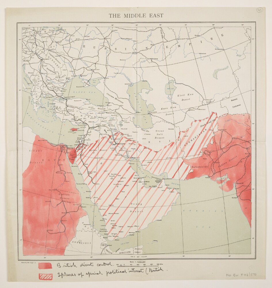
Abstract: Published by 'Admiralty War Staff I[ntelligence].D[ivision].' Covers the Middle East and south-west Asia. Printed map sheet portrays hydrology, railways, settlements, place names and international boundaries. Watercolour shading has been added to show areas of 'British direct control' and 'Spheres of special political interest (British)'.Creation date derived from railway information and extent of British control and political interest.Verso bears the manuscript annotation 'Middle East'.Physical description: Materials: Printed in colour, with manuscript additions in ink and watercolourDimensions: 358 x 360mm, on sheet 431 x 408mm
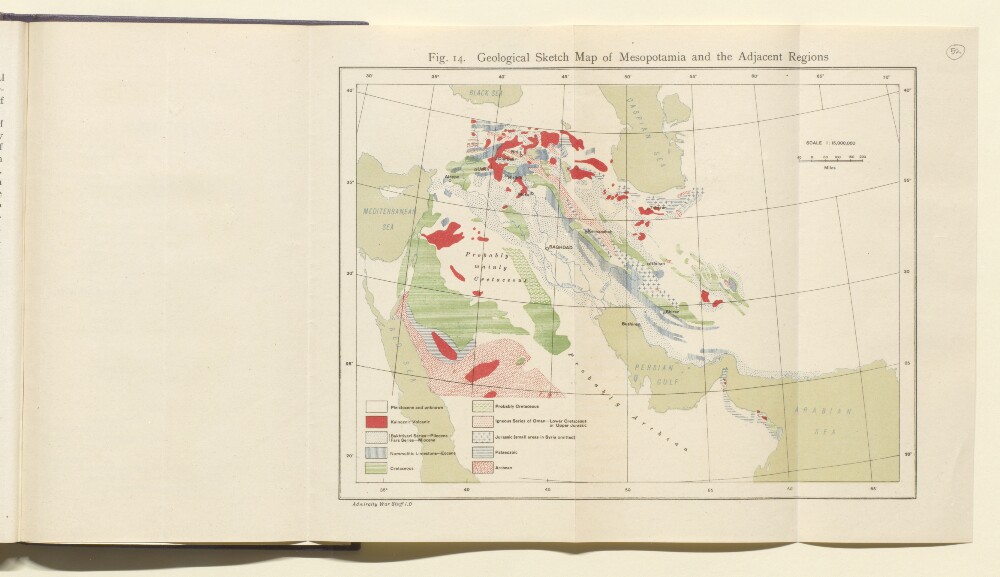
Abstract: Distinctive Features:Sketch map of the Middle East produced to illustrate the geology of Mesopotamia and surrounding region colour coded to show geological periods with a key provided in the bottom left-hand corner.Bottom left-hand corner below neat line: ‘Admiralty War Staff I.D.’.Physical description: Dimensions:180 x 240 mm
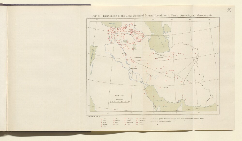
Abstract: Distinctive Features:Sketch map of the Middle East produced to illustrate the geology of Mesopotamia and surrounding region showing the distribution of the chief mineral deposits in the region with a key provided in the bottom margin. Also shows the international boundaries and boundaries of the Russian and the British sphere of influence according to Convention of 1907.Bottom left-hand corner below neat line: ‘Admiralty War Staff I.D.’.Physical description: Dimensions:167 x 230 mm
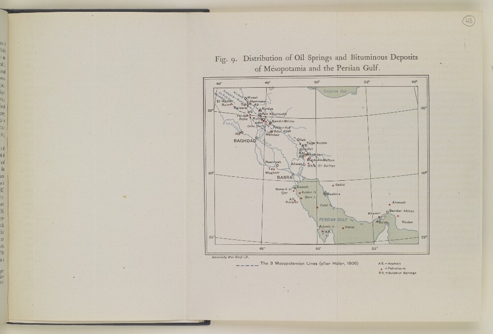
Abstract: Distinctive Features:Sketch map of the Middle East region produced to illustrate the geology of Mesopotamia and surrounding area showing distribution of the oil springs and bituminous deposits in the region. The three lines along which the oil springs and gypsum deposits of the area occur according to Hőfer indicated by pecked line. Contains a key to symbols below map in the bottom right-hand corner.Bottom left-hand corner below neat line: ‘Admiralty War Staff I.D.’.Physical description: Dimensions:200 x 155 mm
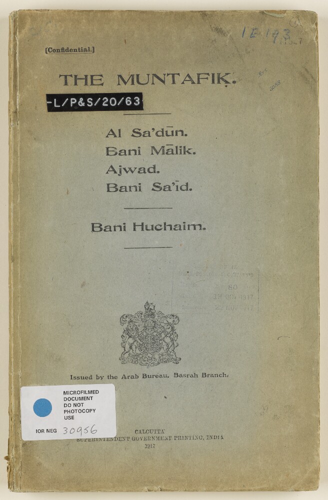
Abstract: This volume contains details of the Muntafik [Muntafiq], a confederacy of tribes in the Middle East, which is made up of tribal groups including the Bani Malik, Ajwad and Bani Sa'id. The volume opens with a historical outline of the development of the group before providing further details about members of the confederacy.There is a map on folio 18 which outlines the divisions and locations of the Bani Malik, and there are genealogical tables for Al Sa'dun between folios 7-17. Folios 19-87 contain lists of the tribes represented under the Muntafik. For some tribes, there are brief notes relating to their location and how they are viewed by other members of the confederacy and by the British.Physical description: Foliation: the foliation sequence for this description commences at the front cover with 1, and terminates at the inside back cover with 89; these numbers are written in pencil, are circled, and are located in the top right corner of the recto side of each folio.
Abstract: This is a secret printed memorandum, dated 1 June 1920, with an introductory note, dated 2 June 1920, by the Edwin Samuel Montagu (initialled E S M), Secretary of State for India. It concerns the question of future British control in Mesopotamia [Iraq] and Middle East. The memorandum discusses the current administrative arrangements in the region following the First World War, the idea of establishing a 'Middle East Office', and considers which department of state (India Office, Foreign Office or Colonial Office) is best qualified to undertake the task of administering Britain's Middle Eastern affairs.Physical description: Foliation: The foliation for this sequence commences at folio 108, and terminates at folio 109, as it is part of a larger physical volume; these numbers are written in pencil, are circled, and are located in the top right corner of the recto side of each folio. An additional foliation sequence is also present in parallel between folios 7-153; these numbers are also written in pencil, but are not circled, and can be found in the same position as the main sequence.