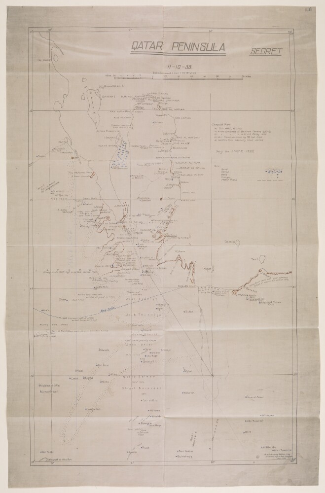
Abstract: Imprint:A.H.Q. [Air Headquarters] Drawing Office Iraq. Drawn by Aprim Bet-Benjamin, Nov. 1935.Distinctive Features:Relief shown by hachures.Map showing the Qatar Peninsula and central part of the Eastern Province Saudi Arabia. Numerous notations concerning terrain features cover the face of the map with routes, the location of wells with good water, and sandy and marshy areas marked.Includes a key to symbols and a list of sources used in compilation of the map.Inscriptions:On verso is an annotation in black ink: ‘Received under Air Officer Commanding, British forces in Iraq’s letter No. S. 10843/2411 dated 19th November 1935; file 61/31. With initials and date ‘12/12/35’.Physical description: Materials:Photographic print with additions in ink and crayon on tracing clothDimensions:592 x 357 mm, on sheet 670 x 431 mm
Abstract: Born in what is now the Eastern Province of Saudi Arabia, ‘Ali ibn al-Muqarrab (1176 or 1177−1231 or 1232) had an adventurous life that included political intrigue and involvement with trade as well as literary accomplishment. Writing in the early 13th century, he is said to have been one of the last poets before modern times to have composed in the classical style. His Diwan (Poetry collection) is lauded for its historical as well as literary qualities. It is considered a primary source for geography and history as well as genealogy and information about the social and cultural conditions of his region. Al-Muqarrab’s tribe, the al-‘Uyuni, ruled portions of the coast of the Arabian Peninsula for more than 150 years, from the 11th to the 13th centuries. Failed political ambitions caused al-Muqarrab to flee to Baghdad and Mosul (present-day Iraq). Historian ‘Abd al-Khalaq al-Janbi discusses many of the strengths and weaknesses of al-Muqarrab as a historian, and notes the confusion in reference works over his name and the authorship of works attributed to him. Manuscripts of the Diwan are found in many Western and Middle Eastern libraries. The edition presented here was printed in Mecca in 1889 and reprinted in Bombay in 1892.Physical description: 120 pages ; 28 centimeters
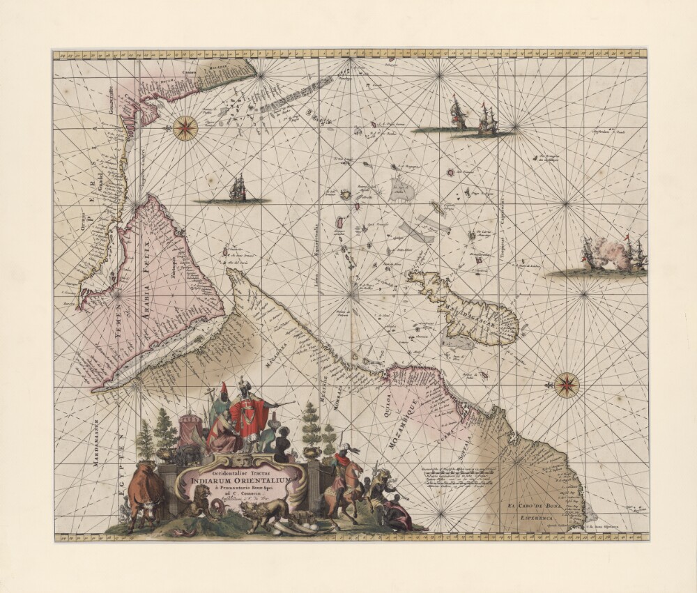
Abstract: This portolan map by the Dutch engraver, publisher, and map seller Frederick de Wit (1629 or 1630-1706) shows the Indian Ocean from the Cape of Good Hope to the west coast of India (Malabar). The map was first published in 1675 and was reprinted in 1715. It is oriented with east at the top. Kishm is placed in the present-day United Arab Emirates (UAE) and repeated as “Quaro” and “Quiximi.” The shape of the Arabian or Persian Gulf differs from that shown on other maps. There is a big island north of Bahrain Island named “Quezimi,” most likely another version of Qishm. Khorfan is shown twice: at one location in the present-day UAE in the Gulf of Corsca and the second on the Omani side, where it is called “Orfacan.” Mascalat, the region, is located at the center of the Arabian Peninsula, while the town of the same name is found south of Tablan, not far from the Arabian coast. “Ormuz,” a territorial name, is found around Oman and the present-day UAE. The Arabian Gulf is called “Mare Elcatif ol Sinus Persicus” (Al Qatif, Persian Gulf), while the Red Sea is marked “Mare Rubrum turcis Mare de Mecca olim Sinus Arabicus” (Red Sea, named Sea of Mecca by Turks and formerly known as the Arabian Gulf).Physical description: 1 map; color; 42 x 53.5 centimeters
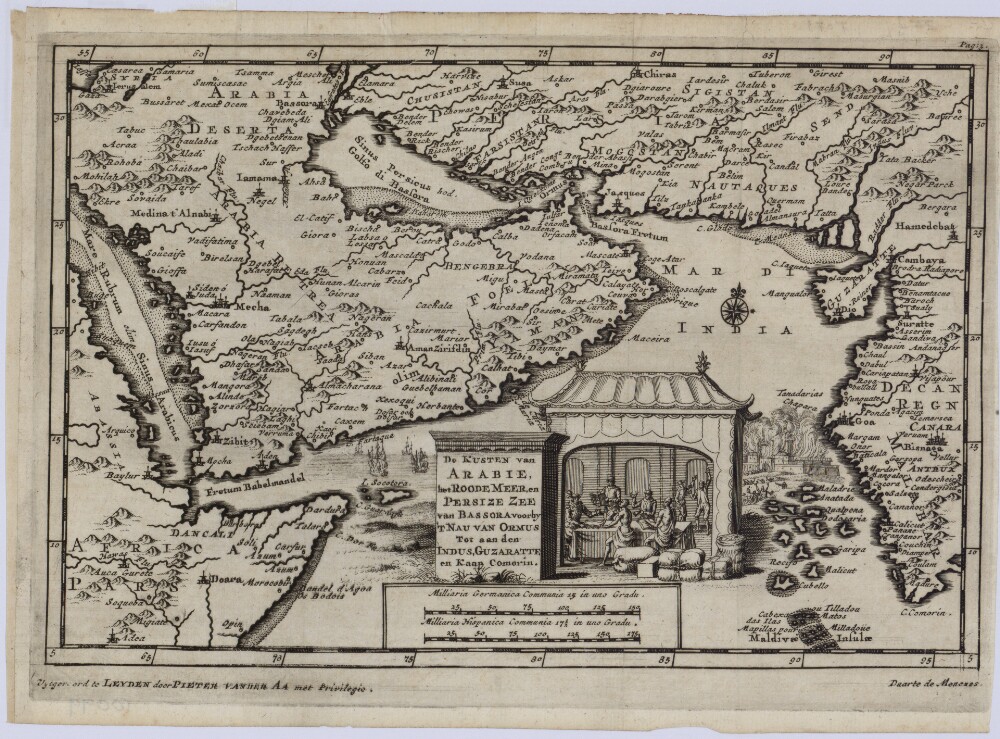
Abstract: This 1707 map of the Arabian Peninsula and adjacent regions is the work of Pieter van der Aa (1659-1733), a Dutch publisher and bookseller based in Leiden who specialized in reissuing maps acquired from earlier mapmakers. The map appears to be based on an earlier Portuguese work, and uses a mix of Dutch, Latin, and Portuguese for titles and place names. The map covers only the eastern and central parts of the peninsula, which is shaped differently than shown on many other maps. The map shows four rivers on the Arabian (western) side, but they reach more deeply into the peninsula than on other maps. The map gives three names for Al Ahsa: “Ahsa,” “Labsa,” and “Lessa.” The Arabian Gulf is called the Persian Gulf or Gulf of Basra. The Strait of Hormuz is called Fretum Bassora or Strait of Basra.Physical description: 1 map; black and white; 14 x 21.50 centimeters
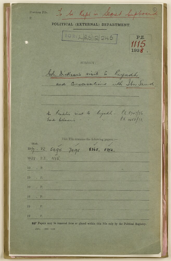
Abstract: The file consists of correspondence and other papers mainly relating to the private visit of Colonel Harold Richard Patrick Dickson to Riyadh, Saudi Arabia, and his three private conversations with King Ibn Saud.It includes correspondence between John Charles Walton, India Office, and Dickson, including a letter from Walton to Dickson of 2 November 1937 enclosing a summary of Dickson’s three private conversations with Ibn Saud, in which the views of Ibn Saud on Palestine and relations with the British Government are quoted (folios 33-44). The file also includes correspondence between Walton and the following concerning the visit: George William Rendel, Foreign Office; Sir Findlater Stewart, India Office; and M J Clauson, India Office.There is also correspondence between the Political Resident in the Persian Gulf and the Secretary of State for India, and between H. Lacy Baggallay, Foreign Office, and M J Clauson, India Office.Physical description: Foliation: the foliation sequence (used for referencing) commences at the front cover with 1, and terminates at the inside back cover with 48; these numbers are written in pencil, are circled, and are located in the top right corner of the recto side of each folio.A previous foliation sequence, which is also circled, has been superseded and therefore crossed out.
Abstract: The file contains reproductions of a map of north-eastern Saudi Arabia and of a road map of Hasa Province, Saudi Arabia, originally prepared by the California Arabian Standard Oil Company.The file also contains correspondence between the War Office, the India Office, the Political Agent, Bahrein [Bahrain] and the Political Resident in the Persian Gulf regarding the question of the Government of Saudi Arabia's granting permission to the Surveyor General of India to reproduce the road map.The file includes a divider which gives a list of correspondence references contained in the file by year. This is placed at the front of the correspondence.Physical description: The foliation sequence commences at the inside front cover with 1 and terminates at the last folio with 23; these numbers are written in pencil, are circled, and are located at the top right corner of the recto side of each folio.
Abstract: The file mainly consists of correspondence between the India Office and the Foreign Office, and enclosed copies of Foreign Office correspondence, relating to the former Amir [Emir] of Mecca, Sherif Ali Haider.It includes a letter from Kenneth Johnstone, Foreign Office, to John Gilbert Laithwaite, India Office, 31 January 1935 (folios 10-11), enclosing a copy of a letter from Princess Fatma Haider (née Miss Dunn), the wife of Sherif Ali Haider, which she sent to the Prince of Wales, and which was passed on to the Foreign Office by the Prince’s Private Secretary. In her letter, dated 10 January 1935 (folios 13-14), Fatma Haider states that her husband is ‘old and delicate’ and describes his difficult financial situation, stating that he was promised £200 of gold a year by the King of Saoud [Saud] when the latter refused to allow her husband to return to Mecca, but that in the present and previous year the King had sent nothing. Fatma Haider’s letter appeals for help from the Prince of Wales ‘through some Mussulman perhaps’. In the letter from Johnstone to Laithwaite of 31 January 1935, Johnstone asks whether the India Office has any observations to make on the matter, and states how the Foreign Office intends to reply to the Prince’s Private Secretary. A reply from Laithwaite to Johnstone of 5 February 1935 (folio 8) states that the India Office has ‘no comments to offer, but note the course of action which the Foreign Office propose to adopt’.A copy of a letter from the Foreign Office to Sir Godfrey Thomas, the Prince of Wales’s Private Secretary, 12 February 1935 (folios 5-7), gives a brief account of the Sherif, and concludes that ‘we have no political reason for wishing to assist him’, and that ‘unless, therefore, His Royal Highness is personally disposed to assist the Sherif indirectly, we can only suggest that a regretful reply in the negative should be returned to Princess Fatma’s request’.The file also includes a copy of letter sent to the Foreign Office from Godfrey Thomas Havard, Consul General, Beirut, 27 March 1935 (folio 3), informing the Foreign Office of the death of Sherif Ali Haider on 24 March 1935.Physical description: Foliation: the foliation sequence (used for referencing) commences at the first folio with 1 and terminates at the last folio with 14; these numbers are written in pencil, and are located in the top right corner of the recto side of each folio.
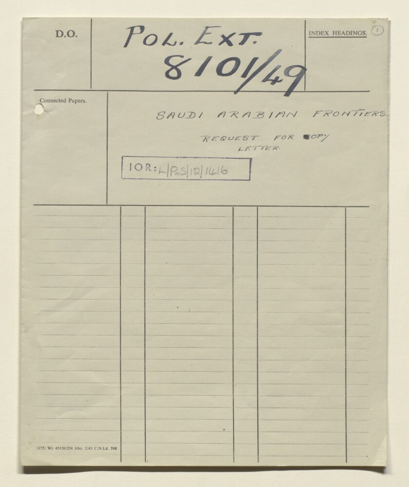
Abstract: This file consists of a single letter from the Foreign Office to the Commonwealth Relations Office requesting a copy of earlier correspondence regarding Saudi Arabian Frontiers.Physical description: Foliation: the foliation sequence (used for referencing) commences at the front cover with 1, and terminates at the inside back cover with 3; these numbers are written in pencil and are located in the top right corner of the recto side of each folio.
Abstract: This file contains British Government correspondence regarding unconfirmed information, provided by the Saudi Arabian Quarantine Administration, of an outbreak of smallpox in local hospitals, following the end of pilgrimage [Hajj].The correspondents are the Commonwealth Relations Office and British Consul at Jeddah.Physical description: Foliation: the foliation sequence (used for referencing) commences at the front cover with 1, and terminates at the inside back cover with 6, these numbers are written in pencil, are circled, and are located in the top right corner of the recto side of each folio.
Abstract: The file consists largely of a report by Mr George William Rendel, Head of the Eastern Department of the Foreign Office in London, on his private tour to the Persian Gulf and also to Saudi Arabia at the invitation of King Ibn Saud, in February and March 1937. This personal account of his trip is preceded by a small amount of correspondence in 1936 relating to his travel arrangements, and is followed by post-tour correspondence in 1937 about the drafting and circulation of his report, on a confidential and limited basis, to the Political Resident in the Persian Gulf, the Political Agent at Kuwait, the Foreign Secretary to the Government of India in the External Affairs Department and other British officials in London, India and the Middle East. The main correspondents are Mr George William Rendel of the Foreign Office and Mr John Charles Walton, Foreign and Political Secretary to the India Office in London.The file includes a divider, which gives a list of correspondence references contained in the file by year. This is placed at the back of the correspondence.Physical description: Foliation: the foliation sequence (used for referencing) commences at the inside front cover with 1, and terminates at the last folio with 102; these numbers are written in pencil, are circled, and are located in the top right corner of the recto side of each folio. An additional foliation sequence is present in parallel between ff 3-102; these numbers are also written in pencil, but are not circled.
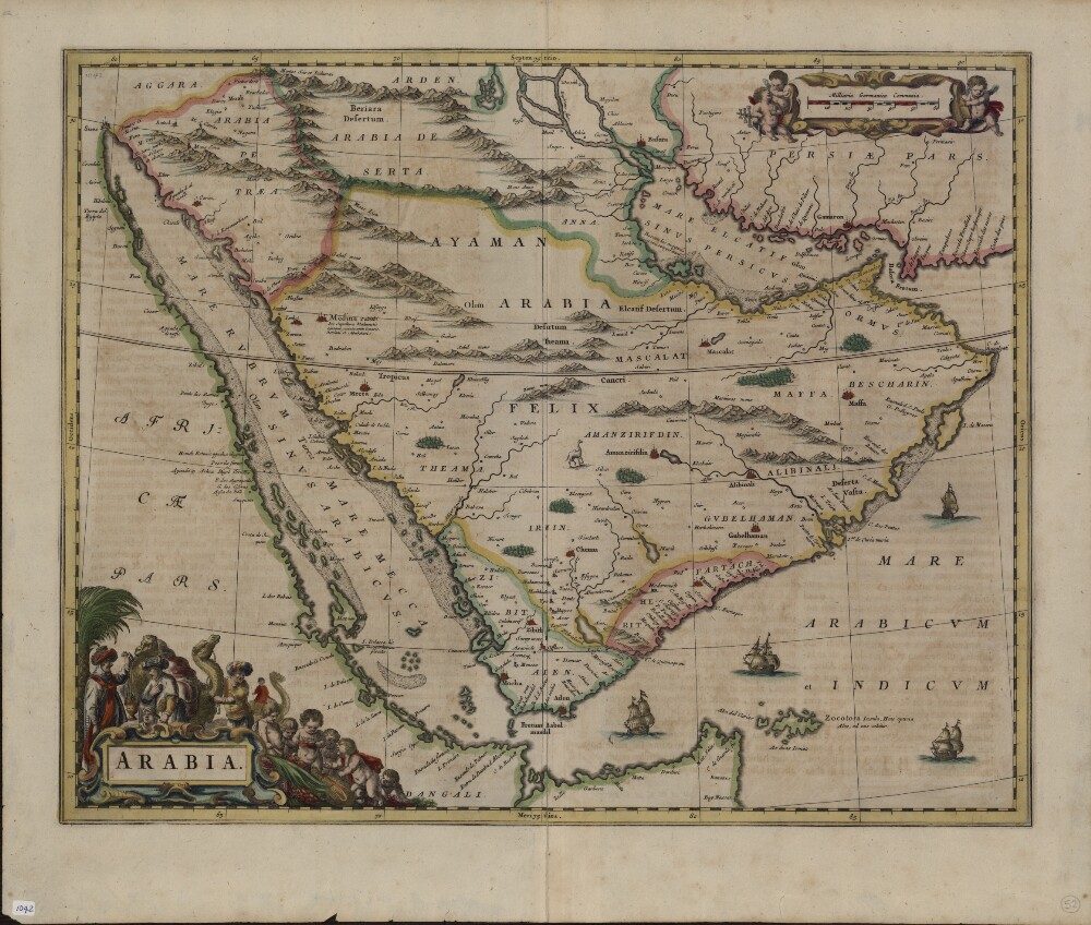
Abstract: This 1662 Latin map of Arabia is a copy of an earlier map by Willem Janszoon Blaeu (1571-1638), the founder of the Blaeu cartographic firm. It is one of the first maps to show internal features of the Arabian Peninsula. Mountains are depicted, oases denoted by trees, and points used to indicate pearl deposits in the Arabian Gulf. The map uses dotted lines to show international borders. The Red Sea is denoted by three Latin names: Mare Rubrum (Red Sea), Mare Mecca (Sea of Mecca), and Sinus Arabicus (Gulf of Arabia). The Blaeu firm published the first edition of the Atlas Novus (New atlas) in 1635. Sons Joan (1596-1673) and Cornelis (died 1648) took over the firm after their father’s death and continued to produce expanded and improved editions of the atlas.Physical description: 1 map; color; 40 x 51 centimeters
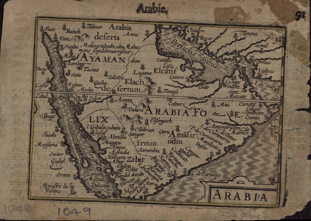
Abstract: This 1616 map is a reprint of a map originally published in 1598 by Jodocus Hondius (1563-1612), a Flemish cartographer and engraver who settled in Amsterdam in about 1593 and established a business that produced globes and the first large maps of the world. The map covers the territory from west of the Gulf of Suez to the eastern side of the Arabian Peninsula, and from the mouth of the Euphrates River to Aden. The only cities indicated on the western coast of the Persian or Arabian Gulf are Qatar (“Catara”), “Godo,” and “Catiffa.” The map shows sandbanks around the coast and rivers at Medina and Mecca. Few towns and regions are shown, and there is a range of mountains in the center of the peninsula. Al Qatif is repeated as the town “Catiffa” and the region “Elcatif.” The peninsula opposite Bahrain Island, shown unnamed, is marked as where “Catara” is found. The commonly noted rivers of the Arabian coast are shown as very close together. The Arabian Gulf is called “Persicus Sinus” (Persian Gulf) and there is no name given for the Red Sea. The Ayaman area is shown as the most populated area on the map. The cartographer uses castles to denote cities and dotted lines to show the division of the Arabian Peninsula into three parts.Physical description: 1 map; black and white; 11.60 x 8.50 centimeters