Number of results to display per page
Search Results
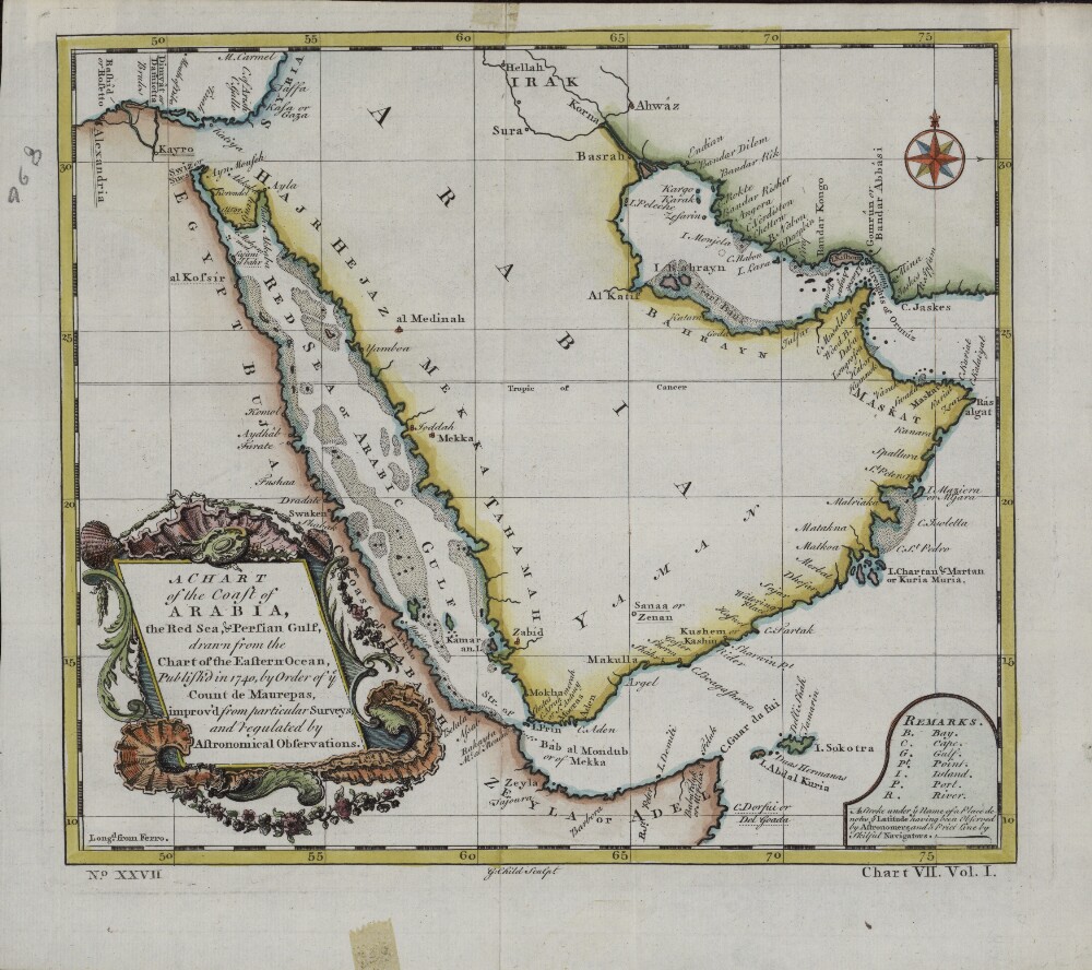
49. A Chart of the Coast of Arabia, the Red Sea and Persian Gulf, Drawn from the Chart of the Eastern Ocean
- Description:
- Abstract: This English map is a reprinting, with slight changes, of an earlier French map published in 1740 by order of Jean-Frédéric Phélypeaux, Count de Maurepas (1701-81), secretary of state under King Louis XV. The map was drawn from an earlier chart of the Eastern Ocean, “improv’d from particular surveys and regulated by astronomical observations.” This English edition of the de Maurepas map has a different title cartouche. The “Remarks” section at the lower right gives abbreviations for physical features on the map, and notes: “ A Stroke under ye Name of a Place denotes ye Latitude having been Observed by Astronomers, and a Prict [sic] Line by skilful Navigators.” Longitude is measured in degrees east of the “Isle de Fer” (Ferro, in the Canary Islands). Town names are as they appeared on the earlier French map. The Red Sea is listed as the “Red Sea or Arabic Gulf.”Physical description: 1 map; color; 22 x 24 centimeters

50. Map of Ancient Arabia
- Description:
- Abstract: This map of the Arabian Peninsula, published in 1720, shows Arabia Felix, Arabia Deserta, and Arabia Petraea. Other regions included are Palestine, Mesopotamia, Chaldea, Persia, Aegyptus, and Aethiopia. A large number of towns are shown. The title cartouche includes nine vignette coins. The tribal and town names on the map are those used by Ptolemy. Some are used more than once, with variations. Thus “Indicara,” “Iacara,” “Ichara,” and “Aphana” all could indicate the same place: the spot where Alexander the Great intended to build a capital on an island in the Arabian Gulf, enabling him to control the trade of the region and extend his empire (a scheme that he was unable to accomplish before he died). Archeological research suggests that this place was Failakah Island in present-day Kuwait, although some historians place it at Abu Ali Island. The map shows a peninsula near present-day Bahrain. The islands of “Arathos” and “Thylaso” indicate Muharraq and Bahrain islands, respectively, which are actually located north of Qatar. On this map, they are placed on the Persian coast side, probably because the cartographer confused them with “Hormuz” and “Qishm.” Qatar is mentioned on the map as “Catara,” but its shape and location are not accurate. The map is by Christoph Weigel, a German engraver, art dealer, and publisher.Physical description: 1 map; color; 35.90 x 29.30 centimeters
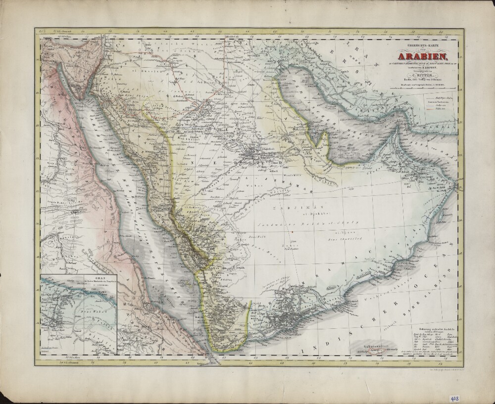
51. Overview Map of Arabia. Based on C. Ritter's Geography Book III, West Asia, Parts XII−XIII
- Description:
- Abstract: German geographer and cartographer Heinrich Kiepert (1818–99) is generally regarded as one of the most important scholarly cartographers of the second half of the 19th century. He was head of the Geographical Institute in Weimar between 1845 and 1852 and professor at the University of Berlin from 1852 until his death. Shown here is Kiepert’s 1852 map of Arabia. As indicated in the title, it is based on “C. Ritter’s geography book.” The latter refers to Die Erdkunde im Verhältnis zur Natur und zur Geschichte des Menschen (Geography in relationship to nature and to the history of humanity), the pioneering 23-volume work of scientific geography published between 1822 and 1859 by the German geographer Carl Georg Ritter (1779−1859). The map contains a wealth of geographic and historical information, including pilgrimage (hajj) routes, the routes in northern Arabia of the explorers George Forster Sadlier (1819) and Georg August Wallin (1848), and explanations in German of Arabic geographic expressions, with abbreviations. At the lower left is an inset map of Oman, which provides much detail, including the routes taken by French naturalist Pierre-Martin-Rémi Aucher-Eloy and East India Company naval officer James Raymond Wellsted. The map was lithographed by the firm of Heinrich Mahlmann (1812−48) and published by Dietrich Reimer, with whom Kiepert had a long association.Physical description: 1 map : lithograph ; 47 x 36 centimeters

52. Colton's Persia, Arabia, Et cetera
- Description:
- Abstract: This map showing the Arabian Peninsula, Persia (present-day Iran), Afghanistan, and Baluchistan (present-day Iran and Pakistan) was published in 1855 by the G.W. and C.B. Colton and Company of New York. Coloring is used to indicate borders and certain provinces or settled areas. The map shows cities, mountains, and roads, and includes some notes on topographical features. The old Qatari city of Al Zabara is shown. The map is accompanied by a one-page summary of the geography, people, principal places, and recent history of Afghanistan and Baluchistan. The map later appeared in the 1865 edition of Colton’s General Atlas and reflects the general level of geographic knowledge of the Middle East in mid-19th-century America. J.H. Colton & Company was founded in New York City, most likely in 1831, by Joseph Hutchins Colton (1800–93), a Massachusetts native who had only a basic education and little or no formal training in geography or cartography. Colton built the firm into a major publisher of maps and atlases by purchasing the copyrights to and republishing other maps before it began creating its own maps and atlases. In the 1850s, the firm became the G.W. & C.B. Colton Company, after Colton brought his sons, George Woolworth Colton (1827–1901) and Charles B. Colton (1832–1916), into the business. As in this example, virtually all Colton maps were framed in decorative borders of intertwining vines, flowers, or geometric shapes.Physical description: 1 map : color ; 31 x 36 centimeters
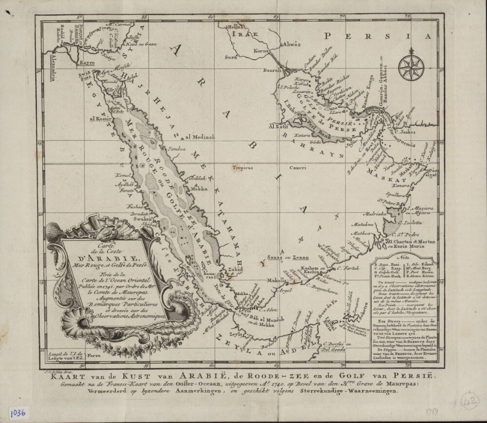
53. Map of the Arabian Coast, Red Sea, and Persian Gulf
- Description:
- Abstract: This map of the coastlines of the Arabian Peninsula and adjacent regions is by the French hydrographer and cartographer Jacques-Nicolas Bellin (1703−72). Bellin was attached to the French Marine Office for more than 50 years and specialized in producing maritime maps. He also made most of the maps for Histoire générale des voyages: ou, Nouvelle collection de toutes les relations de voyages par mer et par terre, qui ont été publiées jusqu'à présent dans les différentes langues de toutes les nations connues (General history of the voyages, or, a new collection of all the accounts of voyages on sea and on land, which have been published up to the present in the different languages of all known countries), a 15-volume compendium edited by Abbé Antoine-François Prévost (1697–1763) and published between 1746 and 1759. This map appeared in the first volume of this work. The map shows coastlines, ports, and coastal shoals. At a time when the determination of location was still an inexact science, a note at upper right explains the use of three different symbols on the map: a star to indicate places where location had been determined by astronomical observations of latitude and longitude; a cross to indicate places where location had been determined by astronomical observations of (only) latitude; and a modified cross to indicate places where location had been determined by latitudinal observations made by skilled navigators.Physical description: 1 map ; 22 x 25 centimeters
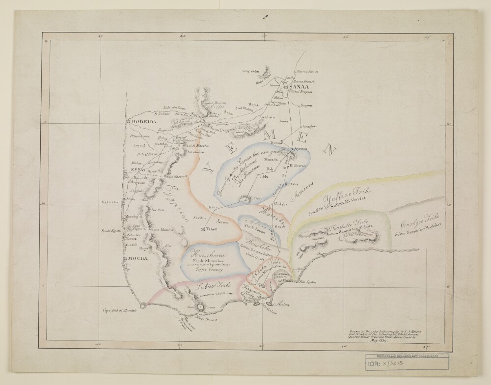
54. A map of the southwestern part of the Arabian Peninsula
- Description:
- Abstract: Imprint:Drawn in Transfer Lithography by L.J. Hebert and Printed at the Lithographic Establishment Quarter Master Generals Office Horse Guards.Distinctive Features:Relief shown by hachures.Shows the location of tribes with rulers’ names given and boundaries indicated by pecked line and coloured. Notations concerning the country cover the face of the map.Physical description: Dimensions:300 x 400 mm
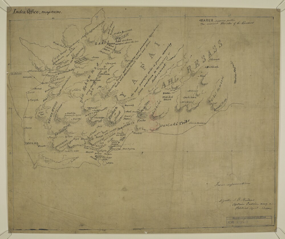
55. A map of the south-western part of the Arabian Peninsula, from Hodeidah to Wady Meifah
- Description:
- Abstract: Distinctive Features:Relief shown by hachures.Notations concerning the agriculture production of the region cover the face of the map.Inscriptions:On recto in the top left hand corner: ‘India Office, maproom’. In the bottom right-hand corner: ‘Signed S.B. Haines, Captain Indian Navy & Political Agent – Aden’.Physical description: Materials:Pen and ink on tracing clothDimensions:400 x 470 mm
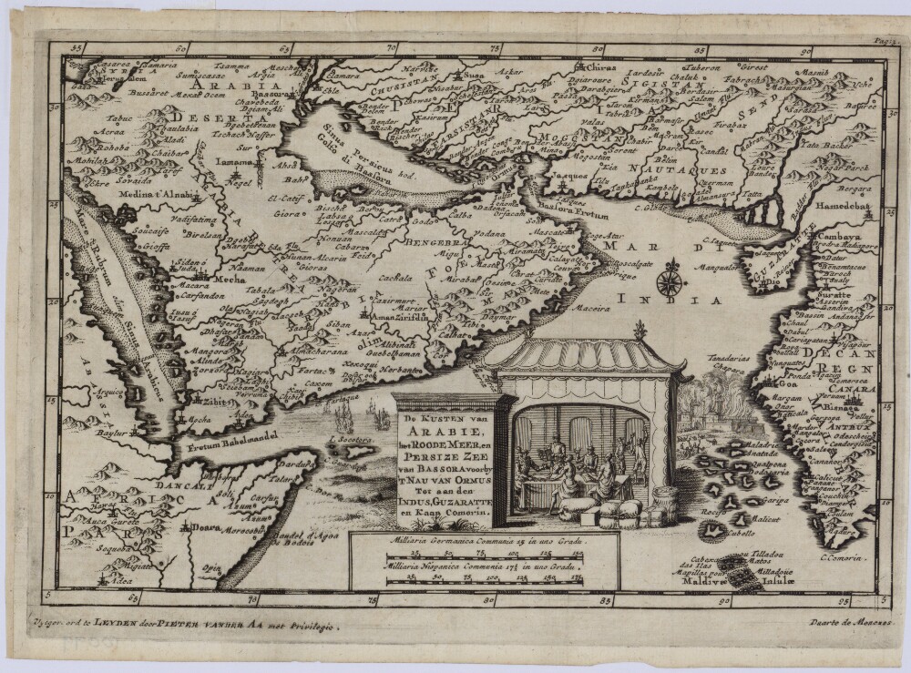
56. The Coast of Arabia the Red Sea, and Persian Sea of Bassora Past the Straits of Hormuz to India, Gujarat and Cape Comorin
- Description:
- Abstract: This 1707 map of the Arabian Peninsula and adjacent regions is the work of Pieter van der Aa (1659-1733), a Dutch publisher and bookseller based in Leiden who specialized in reissuing maps acquired from earlier mapmakers. The map appears to be based on an earlier Portuguese work, and uses a mix of Dutch, Latin, and Portuguese for titles and place names. The map covers only the eastern and central parts of the peninsula, which is shaped differently than shown on many other maps. The map shows four rivers on the Arabian (western) side, but they reach more deeply into the peninsula than on other maps. The map gives three names for Al Ahsa: “Ahsa,” “Labsa,” and “Lessa.” The Arabian Gulf is called the Persian Gulf or Gulf of Basra. The Strait of Hormuz is called Fretum Bassora or Strait of Basra.Physical description: 1 map; black and white; 14 x 21.50 centimeters
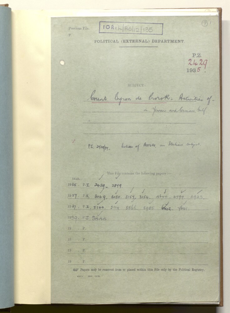
57. PZ 2429/1935 'Count Byron de Prorok: activities in Yemen and Persian Gulf'
- Description:
- Abstract: The file comprises telegrams, despatches, correspondence, memoranda, and notes, relating to the monitoring by British officials of the activities of Count Byron Khun de Prorok and his expeditions in Yemen and the Persian Gulf. This included attempts to search for the ancient lost city of Ubar in the Rubʻ al Khālī and the fabled capital city of the Queen of Sheba.The discussion in the file relates to the correspondence with scientific institutes (Royal Geographical Society; Royal Anthropological Institute) concerning de Prorok's scientific credentials, nationality, name and title. Also discussed is the refusal of the Sultan of Muscat to allow an expedition to proceed from Muscat and the British refusal to allow a start from Sharjah. Also discussed are British concerns about motivations for the expedition and connections with Italian oil interests.Included in the file is a handwritten letter from Prorok to the India Office (folio 32) and an advertisement for an evening lecture at the Pump House, Bath (folio 10).The file contains correspondence between: the Passport Control Department, Foreign Office, London; the Political Resident in the Persian Gulf; and the India Office, London.Physical description: Foliation: the foliation sequence for this description (used for referencing) commences at f 7, and terminates at f 68, as it is part of a larger physical volume; these numbers are written in pencil, are circled, and are located in the top right corner of the recto side of each folio. An additional foliation sequence is present in parallel; these numbers are also written in pencil, but are not circled.

58. Aden Affairs
- Description:
- Abstract: This item comprises enclosures to a despatch from the Government of Bombay [Mumbai] Secret Department to the Secret Committee [Bombay Secret Letter], No. 20 dated 19 March 1856. The enclosures are dated 15 January-19 March 1856.The correspondents are: Brigadier William Marcus Coghlan, Acting Political Resident and Commandant, Aden; the Secretary to the Government, Bombay; and Stephen Page, HM Acting Vice-Consul and Officiating HC [Honourable Company] Agent at Juddah [Jeddah]. The item also includes enclosures to correspondence and one Resolution of the Board.The papers cover the following matters:Coghlan’s decision to continue the British blockade of Berbera, and to disregard the confession (ff 310-311) of a prisoner named ‘Ali Mahomed’ [‘Alī Muḥammad] who has been brought to Aden on the Mahi, since he is not considered to have been the ‘ring leader’ of the attack on the Somali Expedition of Lieutenant Richard Burton and has been repudiated by the Elders [of the Habr Awwal tribe]Events relating to Zailah [Zeila, also spelled Zeylah in this item], including: the attempt by the Haj Shermarki [Ḥājjī Sharmārkī ‘Alī Ṣāliḥ, also spelled Sheumarki and Shermarkie in this item] to retake his position as Governor, from which he was lately ousted by the [Ottoman] Turkish authorities; Coghlan’s attempt to prevent Shermarki blockading Zailah and potentially disrupting British supply chains by sending the Assistant Resident to liaise between Shermarki and the Turkish authorities; Coghlan’s efforts to ascertain the effect of the [Ottoman] Sultan’s proclamation prohibiting slavery at Zailah, considering news of the arrival there of a ‘large slave Caffilah [caravan]’ from the interior (ff 314-315)News obtained from Mocha that cholera has broken out in the camp of the Asseer [‘Asīr tribe] apparently causing the death of their leader and causing the force's retirement from their putative campaign to attack the Red Sea ports of YemenRelations in Aden between the Abdali [al-‘Abdalī] and Oulaki [al-‘Awlaqī]] ‘chiefs’ regarding their mutual claims over the fort of Bir Ahmed [Bir Ahmad], including: a letter sent by the Secretary to the Government, Bombay, to the Resident in Hyderabad asking him to gather information about the apparent influence of one ‘Sirdar Abdulla bin Ali Oulaki’ [Sirdār ‘Abdullāh bin ‘Alī al-‘Awlaqī] a ‘jemadar [jamadar] in the service of His Highness the Nizam of Hyderabad’ (f 322); and Coghlan’s decision to abstain from interference provided that the dispute causes no interruption of tradeIntelligence relating to the state of affairs in Massowah [Massawa, also known as Mitsiwa], including a letter from Raffaello Barroni, Agent to Mr Plowden [Walter Chichele Plowden], HM Consul in Abyssinia [now Ethiopia], reporting the promise of the Naib of Massawa to re-establish order but that the current absence of any governor renders Massawa ‘without soldiers and without protection, and the population … left to herself and committed to fortune’ (f 318)Report by Stephen Page describing the state of affairs in Juddah and its vicinity since the unsuccessful insurrection led by Abu Montallib [Sharif ‘Abd al-Muṭṭalib bin Ghālib bin Musā‘ad], including Page’s: description of the recent engagement at Tayf (to where Abu Montallib had retreated) between ‘Bedouins’ and [Ottoman] Turkish soldiers; concern regarding the delayed arrival of the newly appointed [sharif?] Ebu Aonan [Muḥammad bin ‘Abd al-Mu‘īn bin ‘Awn]; Page’s belief that the arrival at Juddah of the Elphinstonewas effective in preventing further disturbance and his request that it may return there by April to avoid potential attacks by ‘Bedouin’ if Ebu Aonan has not yet arrived; and opinion that Abu Montallib’s rebellion was not properly quashedReports on the prevalence of smallpox and typhoid in the town of Aden.Physical description: 1 item (22 folios)
59. Aden Affairs
- Description:
- Abstract: This item comprises enclosures to a despatch from the Government of Bombay [Mumbai] Secret Department to the Secret Committee [Bombay Secret Letter], No. 17 dated 16 February 1856. The enclosures are dated 5 December 1855-16 Feburary 1856.The primary correspondents are Brigadier William Marcus Coghlan, Acting Political Resident and Commandant, Aden; the Secretary to the Government, Bombay; and Stephen Page, HM Acting Vice-Consul and the HC [Honourable Company] Officiating Agent at Juddah[Jeddah, also spelled Judda and Jiddah in this item]. The item also includes three related Resolutions of the Board.The papers cover the following matters:The ‘tranquil’ state of affairs in Aden, including relations between the Oulaki [Awlaki] and Abdali [‘Abdali] ‘chiefs’ and the gathering of supporters by the Foudheli ‘chief’ [Aḥmad bin Abdullāh al-Faḍlī] regarding his stipend (from the British authorities)News from Mocha and Hodeida [Al Hudaydah] relating to the serious state of affairs in Yemen, notably with regard to a force of the Aseer [‘Asir] tribe, rumoured to be 30,000-40,000 strong, allegedly advancing to take the sea ports of Yemen, including copies of: a letter from the principal merchants of Mocha appealing for British protection; Coghlan’s instructions to the Commander of the HC [Honourable Company] steam frigate Queen, to proceed to Mocha and Hodeida and if necessary assist the ‘subjects of the allied powers living there’, or proceed to Juddah as previously ordered; and Coghlan’s report to Bombay regarding the strength of Ottoman defences at Mocha and HodeidaThe prevalence of smallpox in Aden, including: the possible origins of its introduction to the peninsula by commercial steamships from Calcutta [Kolkata], most probably the Hindustan; a ‘Daily statement of smallpox prevailing amongst the several corps and departments at Aden’, 1 February 1856, by the Medical Department Superintendent, Aden (f 252); and measures taken to stop further spread including the use of the island of Seerah [Sirah] as a quarantine station and the commencement of a vaccination programmeIntelligence, conveyed by the commander of the Queen, regarding the successful suppression by Ottoman authorities and forces of the rebellion in Mecca and Juddah, but their subsequent defeat ‘by Bedouins’ in their attempt to capture Taif [Ta’if] to where the rebel leader Sheriff Abdul Min Tulab [Sharif ‘Abd al-Muṭṭalib bin Ghālib bin Musā‘ad, also spelled abd-el Mutalib and Abn Mootallib in this item] had fledThe political situation in Mussowah [Massawa, also known as Mitsiwa] following the rebellion against the Governor of Massawa, including a copy of a letter to Coghlan from Raffaello Barroni, Agent to Mr Plowden [Walter Chichele Plowden], HM Consul in Abyssinia [now Ethiopia], reporting that the Governor has left in order to summon the support of Egyptian troops; and Coghlan’s later report to Bombay that since the situation is less critical than that in Yemen the commander of the Queenhas left that place for HodeidaTwo letters from Stephen Page, HM Acting Vice-Consul and HC [Honourable Company] Officiating Agent at Juddah, relating to the ‘disturbance in Mecca’: citing the Firman of the Sultan [ruler of the Ottoman Empire] prohibiting slavery as the cause of the rebellion; reporting that the route between Juddah and Mecca is closed; requesting a HC vessel to protect British and British Indian property which is at risk; and reporting that rebel leader Abn Mootallib has fled to Tayf [Ta’if] with 4-5,000 followers.Physical description: 1 item (20 folios)
60. Aden Affairs
- Description:
- Abstract: This item comprises enclosures to a despatch from the Government of Bombay [Mumbai] Secret Department to the Secret Committee [Bombay Secret Letter], No. 18 dated 5 March 1856. The enclosures are dated 13-27 February 1856.The item comprises a report by Brigadier William Marcus Coghlan, Acting Political Resident and Commandant, Aden, to the Secretary to the Government, Bombay, on the situation in the Aden and the Red Sea coast region of Yemen, enclosing five letters conveying intelligence from: Captain John James Frushard, Indian Navy, Senior Naval Officer at Aden and the Red Sea Station; Stephen Page, HM Acting Vice-Consul and Officiating HC [Honourable Company] Agent at Juddah [Jeddah, also spelled Jedda in this item]; Mahmoud Pasha [Maḥmūd Pāshā], Governor of Yemen; Khajia Georgie Kastandi (Teoffani) [Georgie Kostanti Theofani] of Hodeida [Al Hudaydah]; and Haji Abd-er-Rassool [‘Abd al-Rasūl] of Mocha.Coghlan’s report and enclosures chiefly relate to the varying rumours of the advance of a force of between 30,000 and 50,000 of the Asseer [‘Asir, also spelled Aseer in this item] tribe southwards to Yemen with the intention of attacking and capturing Hodeida and other Red Sea ports of that country, and Lahedj [Lahej]. There is particular reference to:The arrival of the Elphinstoneand the Queenat Hodeida and the arrangements put in place by their commanders for the protection of the governor of the town and his familyDetails of the strength of the defences and fortifications at HodeidaThe apparent gratitude of Mahmoud Pasha, Governor of Yemen, for the arrival of the British vessels, his departure north to Lohea [Al Luhayyah] to reassure that town’s inhabitants, enrolment of additional soldiers, and impression that additional military assistance is on its way from Bombay.Coghlan’s report also covers news on the situation in Mecca and Juddah following the recent rebellion, including that: both cities are now tranquil; the rebellion led by Abd-el-Mutalib [Sharif ‘Abd al-Muṭṭalib bin Ghālib bin Musā‘ad] has largely petered out since the military engagement at Tayf [Ta’if, also spelled Taif in this item] between ‘Bedowins’ [Bedouin] and [Ottoman] Turkish soldiers; and that a new Seriff [Sharif] is soon arriving in Mecca.Also included in the item is a Resolution of the Board indicating that the Governor in Council wants the number of volunteers from the Sind Irregular Horse for service at Aden to be raised to a full complement of one hundred men.Physical description: 1 item (10 folios)