Abstract: The sheet contains a section map: Isfahān—Urūjān [Borūjen]—Ardal—Gurāb—Bāzuft—Chilau in Bakhtiāri Country, south-western Persia. It is found in the
Military Report on S. W. Persia, Vol. III. Bakhtiāri Country North of Kārūn Rivercompiled in the Division of the Chief of the Staff, Army Head Quarters, India. It show a cross-sectional view of the route.The map includes a printing statement which reads 'I. B. Topo. Dy. No 8,170. Exd. C. J. A., July 1909. No. 4,907-I., 1909.'.Vertical scale: 1:72,000Physical description: Materials: Printed on paperDimensions: 210 x 639mm
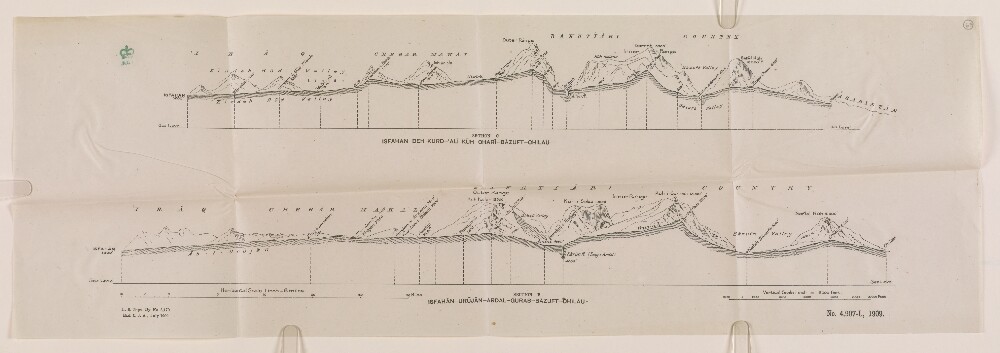
Abstract: The sheet contains a section map: Isfahān—Deh Kurd [Dehie Kord]—'Alī Kūh—Charī—Bāzuft—Chilau in Bakhtiāri Country, south-western Persia. It is found in the
Military Report on S. W. Persia, Vol. III. Bakhtiāri Country North of Kārūn Rivercompiled in the Division of the Chief of the Staff, Army Head Quarters, India. It show a cross-sectional view of the route.The map includes a printing statement which reads 'I. B. Topo. Dy. No 8,170. Exd. C. J. A., July 1909. No. 4,907-I., 1909.'.Vertical scale: 1:72,000Physical description: Materials: Printed on paperDimensions: 210 x 639mm
Abstract: The first edition of
Who's Who in Persia (Volume III) Arabistan, Luristan, Isfahan & Bakhtiari, compiled by the General Staff, India, comprises a biographical dictionary of individuals, families, and tribes connected with those regions in 1922.It also includes a genealogical tree for the Bakhtiari Chiefs (folio 10).The volume was published by the Government Central Press, Simla, 1923.Physical description: Foliation: the foliation sequence (used for referencing) commences at the front cover with 1, and terminates at the inside back cover with 29; these numbers are written in pencil, are circled, and are located in the top right corner of the recto side of each folio. Pagination: the file also contains an original printed pagination sequence.
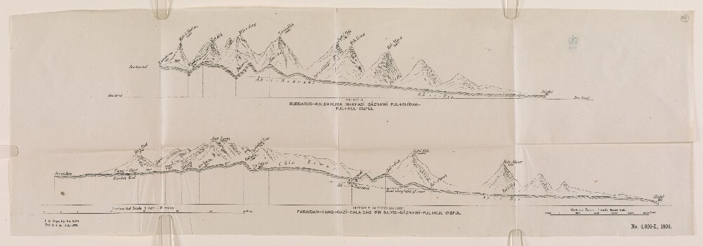
Abstract: The sheet contains a section map: Burbarūd—Kaleh Huma—Makhadī [Makdīn-e Pā’īn]—Bāznawī—Pul-I-Shīrak—Pul-I-Kul—Dizfūl in south-western Persia. It is found in the
Military Report on S. W. Persia, Vol. III. Bakhtiāri Country North of Kārūn Rivercompiled in the Division of the Chief of the Staff, Army Head Quarters, India. It shows a cross-sectional view of the route.The map includes a printing statement which reads 'I. B. Topo. Dy. No 8,174. Exd. C. J. A., July 1909. No. 4,909-I., 1909.'.Vertical scale: 1:72,000Physical description: Materials: Printed on paperDimensions: 214 x 639mm
Abstract: The volume consists of corrections and additions to the biographical dictionary of individuals, families, and tribes given in
Who's Who in Persia (Volume III) Arabistan, Luristan, Isfahan & Bakhtiari, compiled by the General Staff, India, from 1923.Published by the Manager, Government of India Press, Simla, 1924.Physical description: Foliation: the main foliation sequence (used for referencing) commences at the front cover with 1, and terminates at the inside back cover with 6; these numbers are written in pencil, are circled, and are located in the top right corner of the recto side of each folio. An additional foliation sequence is present in parallel between ff 3-6; these numbers are printed, and are not circled.
Abstract: It consists of a military report on S W Persia, specifically Bakhtiāri Country North of Kārūn River, created for the personal information of the officers of the Army in India. Compiled in the Division of the Chief of the Staff, Army Head Quarters, India by Lieutenant A T Wilson, 32nd Sikh Pioneers. Printed at the Government Monotype Press, Simla, 1910.It includes a preface by Wilfrid Malleson, Assistant Quarter Master General, Intelligence Branch.It is divided into the following sections:geographical – boundaries, mountain ranges, rivers, lakes, and geology;general – Bakhtiāri levies, bridge constructions, and revenue;tribal – history, organisation, numbers, customs, land ownership, and taxation;communications – via various routes, condition of tracks, and construction of a cart road;climate;strategical - possibility of collision with Russia and intervention by Great Britain, comparison of routes, recommendations, and composition of force;routes – broken down into stages and incorporating comments on the road, climate, transport, fuel, supplies, water, grazing, and physical obstacles;appendices – including documents relating to the Ahwāz-Isfahān road, tables of tribal sub-divisions and strength of the Haft Lang and the Chehār Lang, and biographical notices of certain Bakhtiāri Khāns by David Lockhart Robertson Lorimer, British Consul, Ahwāz [Ahvāz].Also includes five maps:folio 65: 'SKELETON MAP OF BAKHTIĀRI COUNTRY Showing routes and chief rivers';folio 66: 'SECTION FROM 'ALWĀNĪYEH ('ARABISTĀN) TO KHARĀJĪ THE LYNCH ROAD, ROUTE NO. I. AHWĀZ TO ISFAHĀN';folio 67: 'ISFAHĀN—DEH KURD—'ALĪ KŪH—CHARĪ—BĀZUFT—CHILAU' and 'ISFAHĀN—URŪJĀN—ARDAL—GURĀB—BĀZUFT—CHILAU';folio 68: 'FARAIDAN—TANG-I-GAZĪ—GIL-I-SHĀH—BĀZUFT—CHILAU' and 'FARAIDAN—TANG-I-GAZĪ—PAMBAKĀL—BĀZUFT—CHILAU';folio 69: 'BURBARŪD—KALEH HUMA—MAKHADĪ—BĀZNAWĪ—PUL-I-SHĪRAK—PUL-I-KUL—DIZFŪL' and 'FARAIDAN—TANG-I-GAZĪ—GALA GĀO—PĪR SAIYID—BĀZNAWĪ—PUL-I-KUL—DIZFŪL'.Physical description: Foliation: the foliation sequence (used for referencing) commences at the front cover with 1, and terminates at the inside back cover with 70; these numbers are written in pencil, are circled, and are located in the top right corner of the recto side of each folio. Pagination: the file also contains an original printed pagination sequence.
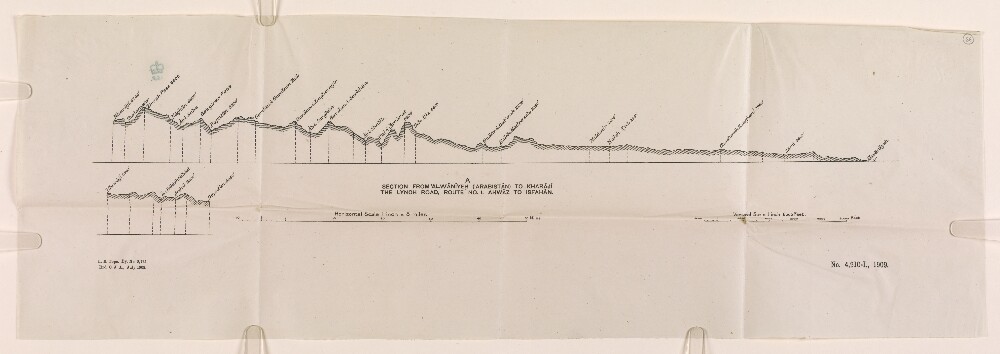
Abstract: The section map shows Alwānīyeh to Kharājī, part of the Lynch Road, Ahwāz [Ahvāz] to Isfahān in south-western Persia. It is found in the
Military Report on S. W. Persia, Vol. III. Bakhtiāri Country North of Kārūn Rivercompiled in the Division of the Chief of the Staff, Army Head Quarters, India. It shows a cross-sectional view of Route No. 1 as described in the volume from folio 30 onwards.The map includes a printing statement which reads 'I.. B. Topo. Dy. No 8,175. Exd. C. J. A., July 1909. No. 4,910-I., 1909.'.Vertical scale: 1:72,000Physical description: Materials: Printed on paperDimensions: 212 x 639mm
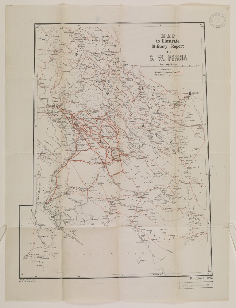
Abstract: The map shows the region of Bakhtiari Garmsir [Bakhtīārī] in south-western Persia. It is found in the
Military Report on S.-W. Persia, Vol. I. Bakhtiari Garmsircompiled in the Division of the Chief of the Staff, Army Head Quarters, India. Routes identified in Volume I and other routes are marked in red.The map includes a printing statement which reads 'I. B. Topo. Dy. No. 8.386. Exd. C. J. A. December 1909. No. 5,049-I., 1909.'.Physical description: Materials: Printed on paperDimensions: 545 x 409mm, on sheet 654 x 499mm
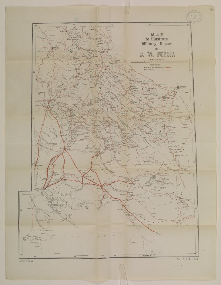
Abstract: The map shows the region of Bakhtiāri in south-western Persia. It is found in the
Military Report on S. W. Persia, Volume. II. Arabistancompiled in the Division of the Chief of the Staff, Army Head Quarters, India. Routes identified in Volume II and other routes are marked in red.The map includes a printing statement which reads 'I. B. Topo. Dy. No. 8, 481. Exd. C. J. A. April 1910. No. 5,133-I., 1910.'.Physical description: Materials: Printed on paperDimensions: 545 x 409mm, on sheet 654 x 499mm
Abstract: The map shows the region of Bakhtiāri in south-western Persia. It is found in the
Military Report on S. W. Persia, Volume IV. Kuhgalu Countrycompiled in the Division of the Chief of the Staff, Army Head Quarters, India. Routes identified in Volume IV and other routes are marked in red.The map includes a printing statement which reads 'I. B. Topo. Dy. No. 8,486. Exd. C. J. A. April 1910. No. 5,137-I., 1910.'.Physical description: Materials: Printed on paperDimensions: 541 x 409mm, on sheet 654 x 499mm
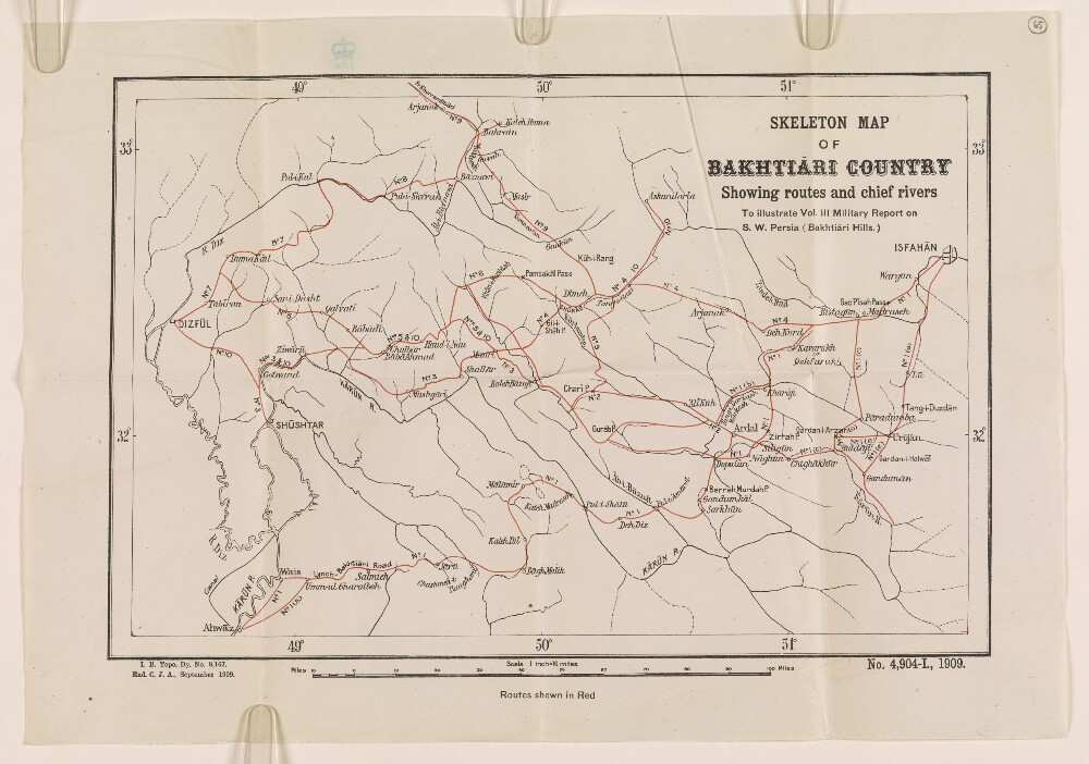
Abstract: The skeleton map shows Bakhtiāri Country in south-western Persia depicting routes and chief rivers in the region. It is found in the
Military Report on S. W. Persia, Vol. III. Bakhtiāri Country North of Kārūn Rivercompiled in the Division of the Chief of the Staff, Army Head Quarters, India. Routes identified in Volume III are marked in red.The map includes a printing statement which reads 'I. B. Topo. Dy. No. 8,167. Exd. C. J. A., September 1909. No. 4,904-I., 1909.'.Physical description: Materials: Printed on paperDimensions: 205 x 312mm, on sheet 278 x 397mm
Abstract: The file contains a printed copy of a letter, sent by Lieutenant-Colonel Arnold Talbot Wilson, Officiating Political Resident in the Persian Gulf, to the Secretary to the Government of India, concerning the protection of the oil fields operated by the Anglo-Persian Oil Company (APOC) in the Arabistan region of Bakhtīārī. Wilson’s letter contains a précis of the protection given to the oilfields during the First World War, the current extent of oil extraction facilities in the region, justification for their continued protection, and his own recommendations for this protection.Physical description: Foliation: The foliation sequence commences at the first folio and terminates at the last folio; these numbers are written in pencil, are circled, and are located in the top right corner of the recto side of each folio.Pagination: The booklet contains an original typed pagination sequence.