Number of results to display per page
Search Results

13. 'Persian Baluchistan (including the Sarhad and Persian Mekran) The Quetta-Nushki extension railway'
- Description:
- Abstract: The memorandum is concerned with Persian Baluchistan, specifically focusing on Mekran [Makran] and Sarhad, which are regarded as being of particular geopolitical interest to Britain's Indian Empire. It includes a brief description of these regions, outlines local British activities during the First World War to counter threats to their interests, and presents the current situation in Mekran and Sarhad. It also outlines proposals put forward by the Government of India in 1917 for reorganising the administration of Persian Baluchistan, with a view to protecting Britain's Indian Frontier and telegraph lines through Persia. This includes an explanation of objections put forward by the Foreign Office to these proposals.The rest of the memorandum is dedicated to the Quetta-Nushki railway extension to Duzdap [Zāhedān]; it is considering a proposal for the destruction of this extension. To this end, it includes a short history of its construction, examines the economic and political advantages of the line, and considers the possibility of a further extension of the line into Seistan [Sīstān].Physical description: Foliation: the foliation sequence commences at the first folio with 1 and terminates at the last folio with 17; these numbers are written in pencil, are circled, and are located in the top right corner of the recto side of each folio.
14. 'Baluchistan and Persia. Note by Sir Dennis Fitzpatrick'
- Description:
- Abstract: This file consists of a note, written by Sir Dennis Fitzpatrick, member of the Council of India, on the subject of the northernmost portion of land in the province of Baluchistan [Balochistān], south of the Durand line, which is described as being situated between British India and Kelat [Kalat] on the east side, and Persia on the west side.The note begins by referring directly to the following letter of correspondence: 'Letter from India, No. 189, Secret,' dated 19 October 1899. The note is principally concerned with the costs and benefits of a proposed railway line, which would run from Nushki (recently taken over by the British from the Khan of Kelat) to Koh-i-Malik-Siah [Malek Sīāh Kūh], in Seistan [Sīstān].The file questions the argument that such a railway line would counteract Russian influence in Seistan. Also discussed is the extent to which the Government of India should be expected to finance such a scheme. Fitzpatrick makes the argument that it is wider Imperial interests, rather than those of the Government of India, which are most at stake, and that therefore a distribution of the cost should be made by fixed shares, rather than by relying solely on Indian revenues. He concludes by referring to a note that he wrote some months earlier, in which he advised that the control of all British affairs west of Baluchistan and Afghanistan should be vested exclusively in the Foreign Office.Physical description: Foliation: the foliation sequence commences at the first folio, and terminates at the last folio; these numbers are written in pencil, are circled, and are located in the top right corner of the recto side of each folio.Pagination: the volume also contains an original printed pagination sequence.
15. 'REPORT on the Working of the Line of Communication AND ON THE Withdrawal of the British Military Mission IN EAST PERSIA, 1919-20. GENERAL STAFF INDIA.
- Description:
- Abstract: The volume is titled Report on the Working of the Line of Communication and on the Withdrawal of the British Military Mission in East Persia, General Staff India. The volume is marked confidential and was printed in Delhi by Superintendent Government Printing, India, in 1921.The report is from the General Officer Commanding, Baluchistan District to the Chief of the General Staff; the report contains preliminary remarks on 'The withdrawal of the troops of the British Military Mission at and beyond Meshed, and of the Lines of Communication'. There follows the substantive report from the Inspector-General of Communications, East Persia, Duzdap to the General Staff, Baluchistan District, Quetta. This report is divided into two parts:Part I - 'A brief report on the working and organization of the Line of Communications, East Persia, in April 1920'Part II - 'The withdrawal' which has the following sub-sections: general; supply and transport services (including some special points for consideration); medical; ordnance; works; posts and telegraphs; vetinary.The report is accompanied by nine maps:'APPENDIX 1. SKETCH MAP SHOWING POSITION OF POST AND COMBINED OFFICES IN EAST PERSIA' (folio 10)'APPENDIX 1. L. OF C.E.P. INTELLIGENCE SYSTEM' (folio 12)'APPENDIX 2. AREA ON THE EAST PERSIA L. OF C. COMMON TO RAIDING (folio 15)'APPENDIX 1. GRAPHIC MAP ILLUSTRATING THE NORMAL SOURCES FROM WHICH THE TROOPS IN EAST PERSIA WERE SUPPLIED AND THE CONTINUOUS MOVEMENTS BY WHICH THE SUPPLIES WERE NORMALLY DISTRIBUTED TO THE FORCE AT MESHED AND TO THE GARRISONS OF POSTS ON L. OF C.' (folio 18)'APPENDIX 1. LINES OF COMMUNICATION EAST PERSIA' (folio 33)'APPENDIX 3. DIAGRAM SHOWING POSITIONS OF TELEPHONE, TELEGRAPH AND COMBINED OFFICES IN EAST PERSIA' (folio 35)'COLUMNS AND CONVOYS WOKRING IN CONNECTION WITH WITHDRAWAL FROM EAST PERSIA' (folio 55)'DAYS AFTER ZERO' (folio 62)'PLAN showing ORGANIZATION OF LINE OF COMMUNICATIONS (ADMINISTRATIVE AND DEFENCE TROOPS) (folio 77)Physical description: Foliation: the foliation sequence for this description commences at the front cover with 1, and terminates at the inside back cover with 78; these numbers are written in pencil, are circled, and are located in the top right corner of the recto side of each folio.Pagination: the volume also contains an original printed pagination sequence.
16. 'Military Report of the Nushki-Chagai-Western Sinjarani Country'
- Description:
- Abstract: A report, marked as secret, on the area of Nushki, Chagai, and Western Sinjarani. The report was compiled in the Intelligence Branch, Quarter Master General's Department. The report was commenced in 1897 by Captain R E Roome, 6th Bombay Cavalry (Jacob's Horse), and revised and completed by Major W C Walton, 104th Wellesley's Rifles, Deputy Assistant Quarter Master General in 1903. It was printed at the Government Central Printing Office, Simla, in 1904.The report includes a preface by Colonel John E Nixon, Assistant Quarter Master General, Intelligence Branch (folio 5) and a glossary of vernacular terms used (folio 6). The main body of the report contains chapters on geography, communications, fortified posts and forts, climate, sanitation, resources, ethnography, history, administration, and military strength.The second part of the report includes a gazetteer of topographical and ethnographic information (folios 36-127) and appendices covering wells, canals, and meteorology, and including a report on the signalling stations of the Dalbandin-Robat line, with sketches (folios 131-147).The volume includes the following maps:Map of Southern Baluchistan (folio 2)Sketch Map of Signalling Line from Dalbandin to Robat (folio 148)Map of Persian Seistan [Sistan] Cultivated Area (folio 149).Physical description: Foliation: the foliation sequence (used for referencing) commences at the front cover with 1, and terminates at the inside back cover with 149; these numbers are written in pencil, are circled, and are located in the top right corner of the recto side of each folio.
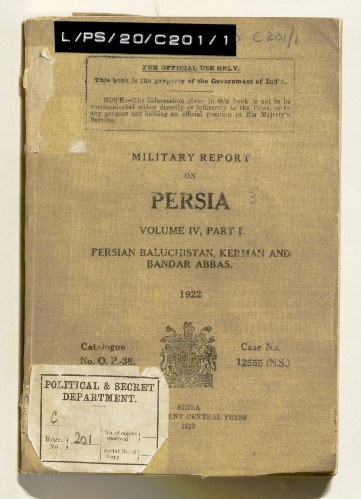
17. 'MILITARY REPORT ON PERSIA. VOLUME IV, PART I.'
- Description:
- Abstract: The volume is entitled Military Report on Persia. Volume IV Part I. Persian Baluchistan, Kerman and Bandar Abbas.(Simla, Government Central Press, 1923). The volume was originally published in 1921.The report contains sections on history, geography, population, climate and health, resources, military affairs, communications, and political matters. Appendices give the following information: details of nomad tribes of Kerman Province; a list of Chiefs and Headmen in Persian Baluchistan, who are in receipt of subsidies from the Indo-European Telegraph Department (IETD); statistics of natural resources; and distribution statement of the Sarhad Levy Corps on 1 July 1922. There are also seven maps (folios 75-81), entitled:Map accompanying Military Report on Persia Vol. IV Part I.Kerman and environsBandar AbbasDiagram of Mirjawa station yardDiagram of Duzdap station yardSignalling and heliograph posts between Chahbar and GehSketch Map shewing communications between Kerman and SaidabadPhysical description: Foliation: the foliation sequence for this description commences at the front cover with 1, and terminates at the inside back cover with 82; these numbers are written in pencil, are circled, and are located in the top right corner of the recto side of each folio. Pagination: the volume also contains an original printed pagination sequence.
18. ‘Military report on Persia. Vol IV, part I. Persian Baluchistan, Kerman and Bandar Abbas.’
- Description:
- Abstract: Military report on Persia (volume IV, part I, covering Persian Baluchistan, Kermān and Bandar Abbas [Bandar-e ʻAbbās]), dated 1922, and published by the Central Government Press at Simla in 1923. The report’s chapters cover:History, including: Persia’s recent political history; a recent history of Persian Baluchistan, and military operations in Persia Baluchistan, notably the operations at Dizak in 1901-02, operations against maritime arms trafficking in 1909, an expedition against Makrān in 1911 to check arms trafficking, and operations against the Dāmānīs in East Persia in 1916, to protect British interests in Persia; b) a brief history of Kermān; and c) a brief history of Bandar-e ʻAbbās.Geographyfor Persian Baluchistan; Kermān; and Bandar-e ʻAbbās, with headings for boundaries, administrative districts, and the principal villages for each region, as well as sections on rivers, lakes, mountains, harbours and deserts as appropriate. The section on Bandar-e ʻAbbās includes a description of buildings, water supply, camping grounds, roads and local industry. There are also descriptions of the principal islands off the Persian Baluchistan coast: Qishm [Qeshm], Henjam [Hengam] and Hormuz.Ethnography, including: general characteristics; notes for intelligence officers; sections on the population and tribes of Persian Baluchistan, Kermān Bandar-e ʻAbbās.Climate and Health, including details of medical facilities.Resources, including: transport (camels, mules, donkeys, horse and oxen); and supplies, chiefly of agricultural crops, by region and village.Military, including: British garrisons and South Persia Rifles; the Persian Army; the fighting strength of the Persian tribes, organised by region and village; military notes on Persian Baluchistan, including the arms traffic in the Persian Gulf.Communications, including: the railway line between Mirjāwā [Mīrjāveh] and Duzdāp, its facilities (water, rolling stock, telegraph), and risks of damage to the line; other proposed lines between Bandar-e ʻAbbās and Kermān, and Gwadar and Kermān; cable, wireless, telephone lines, and visual signalling stations.Political, including an outline of administration in Persian Baluchistan, Kermān and Bandar-e ʻAbbās, and information on currency, weights and measures.Appendix A is a list of the nomadic tribes of the Kermān province, listed by district and the number of families in each tribe. Appendix B is a list of the annual subsidies paid to chiefs in Persian Baluchistan by the Indo-European Telegraph Department, for the protection of lines passing through their district. Appendix C is a table of resources (livestock, agricultural produce), with figures indicating the requirements for local consumption in each district. Appendix D is a distribution statement of the Sarhad Levy Corps as of 1 July 1922.The maps and plans include: a map of Persian Baluchistan (folio 78); a map of Kerman and its environs (folio 77); a diagram of the Mīrjāveh station yard (folio 74); a diagram of Duzdāp station yard (folio 76); a sketch map showing signalling and heliograph posts between Chahbar and Geh (folio 75); and a sketch map showing communications between Kerman and Saidabad (folio 79).Physical description: Pagination: The report has a printed pagination sequence. Page numbers appear at the top and centre of each page.Foliation: There is a foliation sequence, which is circled in pencil, in the top-right corner of the recto of each folio. It begins on the first folio with text, on number 1, and ends on the last of the various maps and plans that are inserted at the back of the volume, on number 79. Total number of folios: 79. Total including covers and flysheets: 81. Note that the foliation sequence on the maps and plans does not follow the order that the maps and plans are listed on the volume’s contents page (f.2). The plan of Bandar Abbās, listed on the report contents page, is missing from the volume.

19. ‘A PART OF BELUCHISTAN WITH PART OF MEKRAN AND THE PERSO-BELUCH BOUNDARY DRAWN & COMPILED BY CAPTAIN BERESFORD LOVETT R.E. attached to the Special Mission to Mekran UNDER MAJOR GENERAL F.J. GOLDSMID, C.B. From actual surveys by Major E.C. Ross, Assistant Political Agent, Gwadur; Captain Beresford Lovett, R.E.; and Quarter Master Serjeant D. Bower, R.E.’
- Description:
- Abstract: Imprint:Trel. Saunders, India Office. Lithographed from tracings entitled: ‘Beluchistan, comprising Mekran and the Perso-Beluch Boundary’.Distinctive Features:Relief shown by shading.Coloured for reference with boundary indicated by pecked line and tinted pink. Routes shown in red and Indo-European Telegraph by a black thin line. Includes explanation to symbols.Physical description: Dimensions:570 x 692 mm, on sheet 646 x 765 mm
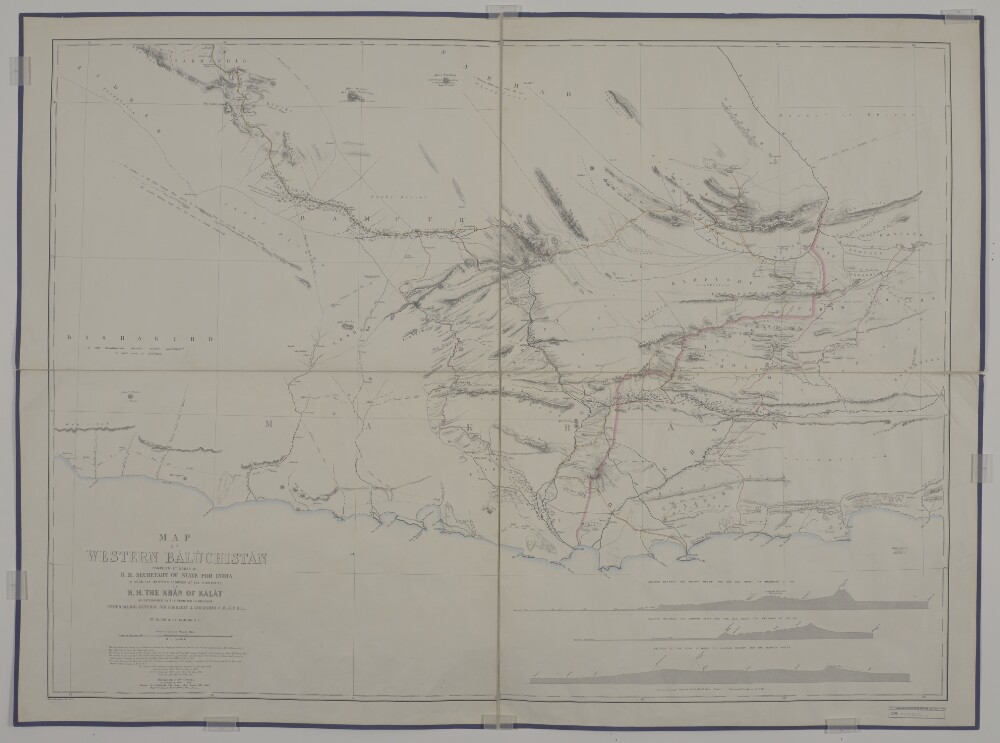
20. ‘Map of Western Baluchistan Compiled by Order of H.M. Secretary of State for India to Show the Western Frontier of the Territories H.H. the Khan of Kalat as Determined by the Frontier Commission Under Major General Sir Frederic J. Goldsmid C.B., K.C.S.I., by Major O.B.C. [Oliver Beauchamp Coventry ] St. John R.E.’
- Description:
- Abstract: Distinctive Features:Relief shown by shading and spot heights. Boundary indicated by pecked line and tinted pink; unexplored areas labelled. Routes of various expeditions shown in colour with names of explorers and dates of their journeys given. Numerous notations on topographic features inserted on the map. Includes three longitudinal sections, a descriptive note on sources used in compilation of map and a key to colours.Physical description: Dimensions:914 x 1249 mm, on sheet 1008 x 1360 mm
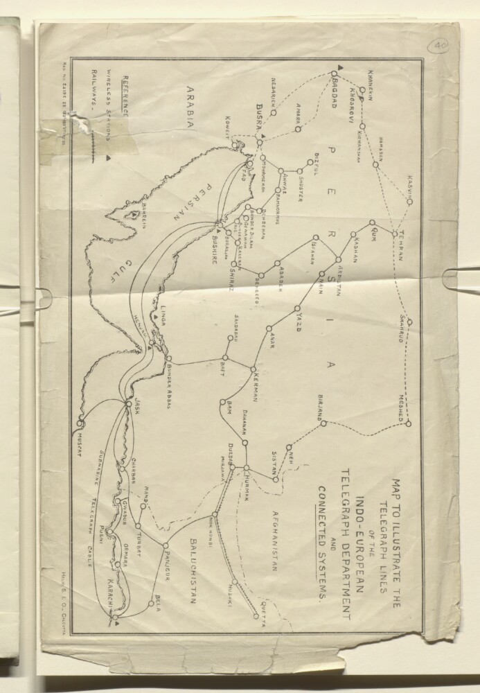
21. ‘MAP TO ILLUSTRATE THE TELEGRAPH LINES OF THE INDO-EUROPEAN TELEGRAPH DEPARTMENT AND CONNECTED SYSTEMS’
- Description:
- Abstract: The map illustrates the telegraph lines operated by the Indo-European Telegraph Department and connected systems across Persia, the Persian Gulf, Iraq, and Baluchistan. It also includes railway lines (dashed lines) and wireless stations (triangles). A reference key is provided, but no scale is given.The map was heliographed by the Survey of India Offices in Calcutta as per the printing statement ‘S.I.O., CALCUTTA’.Physical description: Materials: Printed on paperDimensions: 223 x 343mm
22. 'Gazetteer of the Persian Gulf. Vol I. Historical. Part II. J G Lorimer. 1915'
- Description:
- Abstract: This volume is Volume I, Part II (Historical) of the Gazetteer of the Persian Gulf, ’Omān and Central Arabia(Government of India: 1915), compiled by John Gordon Lorimer and completed for press by Captain L Birdwood.Part II contains an 'Introduction' (pages i-iii) written by Birdwood in Simla, dated 10 October 1914, 'Table of Chapters, Annexures, Appendices and Genealogical Tables' (pags v-viii), and 'Detailed Table of Contents' (ix-cxxx). These are also found in Volume I, Part IA of the Gazetteer(IOR/L/PS/20/C91/1).Part II consists of three chapters:'Chapter X. History of ’Arabistān' (pages 1625-1775);'Chapter XI. History of the Persian Coast and Islands' (pages 1776-2149);'Chapter XII. History of Persian Makrān' (pages 2150-2203).The chapters are followed by nineteen appendices:'Appendix A: Meteorology and Health in the Persian Gulf' (pages 2205-2211);'Appendix B: Geology of the Persian Gulf' (pages 2212-2219);'Appendix C: The Pearl and Mother-of-Pearl Fisheries of the Persian Gulf' (pages 2220-2293);'Appendix D: Date Production and the Date Trade in the Persian Gulf Region' (pages 2294-2307);'Appendix E: Fisheries of the Persian Gulf' (pages 2308-2318);'Appendix F: Sailing Craft of the Persian Gulf' (pages 2319-2332);'Appendix G: Transport Animals and Livestock of the Persian Gulf Region' (pages 2333-2348);'Appendix H: Religions and Sects of the Persian Gulf Region' (pages 2349-2385);'Appendix I: Western Christianity and Missions in the Persian Gulf Region' (pages 2386-2399);'Appendix J: The Telegraphs of the Persian Gulf in their relation to the Telegraph Systems of Persia and Turkey' (pages 2400-2438);'Appendix K: Mail Communications and the Indian Post Office in the Persian Gulf' (pages 2439-2474);'Appendix L: The Slave Trade in the Persian Gulf Region' (pages 2475-2516);'Appendix M: Epidemics and Sanitary Organization in the Persian Gulf Region' (pages 2517-2555);'Appendix N: The Arms and Ammunition Traffic in the Gulfs of Persia and ’Omān' (pages 2556-2593);'Appendix O: The Imperial Persian Customs' (pages 2594-2625);'Appendix P: Cruise of His Excellency Lord Curzon, Viceroy of India, in the Persian Gulf [1903]' (pages 2626-2662);'Appendix Q: British and Foreign Diplomatic Political; and Consular Representation in the Countries Bordering on the Persian Gulf' (pages 2663-2699);'Appendix R: Book References' (pages 2700-2736)'Appendix S: Explanation of the System of Transliteration' (pages 2737-2741).Physical description: The foliation sequence is circled in pencil, in the top right corner of the recto of each folio. It begins on the first folio with text, on number 879, and ends on the last folio with text, on number 1503.
23. 'Gazetteer of the Persian Gulf. Vol. II. Geographical and Statistical. J G Lorimer. 1908'
- Description:
- Abstract: This volume is Volume II of the Gazetteer of the Persian Gulf, ’Omān and Central Arabia(Government of India: 1908) compiled by John Gordon Lorimer. The volume is a geographical dictionary with a series of alphabetically arranged articles relating to the physical and political conditions of the Persian Gulf and its surrounding areas.Pages i-iv are an 'Introduction' to the volume written by John Gordon Lorimer at Strathmartine, Dundee, on 24 December 1908. Details are given within the introduction concerning the content and arrangement of principal and subordinate articles and explanations of estimates of distance and time and other statistical information.Lorimer's introduction identifies the principal articles as:'’Omān Sultanate' (pages 1382-1425);'’Omān (Trucial)' [Trucial Oman] (pages 1425-1451);'Qatar' (pages 1505-1535);'Bahrain Principality' (pages 233-253);'Hasa Sanjāq' (pages 657-679);'Kuwait Principality' (pages 1058-1077);'Najd' (pages 1313-1351), supplemented by articles on 'Najd (Southern)' (pages 1351-1359), 'Qasīm' (pages 1485-1503) and 'Shammar (Jabal)' (pages 1732-1748);'’Irāq (Turkish)' (pages 759-882);'’Arabistān' (pages 115-151), suppplemented by articles on '’Arabistān (Northern)' (pages 151-157) and '’Arabistān (Southern)' (pages 157-165);'Persian Coast' (pages 1455-1468);'Makrān (Coast of Persian)' (pages 1130-1155).All articles have a similar form. The English and Arabic place or tribe name appears in the right or left margin, followed by the text of the article split into sub-sections and with topographical information arranged in tables. Arabic words are given in the text next to their equivalent transliterated into Latin script, with the transliteration system employed appearing in 'Appendix S' in Volume I, Part II (IOR/L/PS/20/C91/2, pages 2737-2741).Topics of information contained within the articles include: boundaries and sub-divisions; physical character and main features (for example, mountains and rivers); climate and seasons; natural products (vegetable, animal and mineral); agriculture and crops; livestock, including transport animals; inhabitants, with reference to racial and tribal distinctions, religious differences, mode of life, character, language, customs, dress and arms, and estimates of populations; trade (internal and external), with notice to currency, weights and measures, shipping, manufactures and industries, and miscellaneous occupations; communications by land and water, with descriptions of routes and estimates of transport; administration and government, especially police, justice, military resources, taxation and finance, and political constitution; and, international position and foreign interests, especially British and their representation in the country. Lorimer refers readers to the Appendices of Volume I, Part II (IOR/L/PS/20/C91/2, pages 2205-2741) for fuller details concerning: meteorology, health, date cultivation, transport animals and livestock, religions and sects, trade, sailing vessels, fisheries, pearl fisheries, and postal and telegraphic communications.There are fifty-six folios lacking page numbers that contain illustrations. The images are labelled as follows:'Wādi Bani Habīb in Jabal Akhdar'. Photographer: Major Percy Zachariah Cox;'A Creek near Basrah from the Shatt=al=’Arab'. Photographer: Major Percy Zachariah Cox;'Bridge of Boats, Baghdād'. Photographer: Major G Arbuthnot;'The Hanaini well, Bahrain Island'. Photographer: John Calcott Gaskin;'Ancient Tumuli, Bahrain Island'. Photographer: John Calcott Gaskin;'Village of Qatārah Baraimi Oasis'. Photographer: Major Percy Zachariah Cox;'The ’Ashshār creek in Basrah Town'. Photographer: Mr Albert Charles Wratislaw;'The British Consulate. Basrah, from the Shatt=al=’Arab. (Consulate building on the right of picture)'. Photographer: Major Percy Zachariah Cox;'Parade of British and Persian troops at Rīshehr, 1905';'Part of the town of Būshehr';'The Sea Front, Būshehr Town';'The British Political Residency, Būshehr';'Bridge at Buziyeh'. Photographer: Major Percy Zachariah Cox;'The Fort [Qasr al-Ḥuṣn] of the Shaikh at Abu Dhabi'. Photographer: Herr Hermann Burchardt;'The Shaikh of Sharjah's Fort at Dhaid, Trucial Oman'. Photographer: Major Percy Zachariah Cox;'Dizfūl Town'. Photographer: Major G Arbuthnot;'Dohah in Qatar'. Photographer: Herr Hermann Burchardt;'A Canal in the Fallāhiyeh District'. Photographer: Major Percy Zachariah Cox;'A Creek at Fāo'. Photographer: Mr W D Cumming;'Muti at the head of Wādi Halfain'. Photographer: Major Percy Zachariah Cox;'Near the village of Qārah in the Hasa Oasis'. Photographer: Herr Hermann Burchardt;'The village of Qārah in the Hasa Oasis'. Photographer: Herr Hermann Burchardt;'Desert bewteen the Hasa Oasis and Qatar'. Photographer: Herr Hermann Burchardt;'The Imāmzādeh of Haidar Karār at the place of formation of the Hindiyān River'. Photographer: Major Percy Zachariah Cox;'The Hindyān River near Zaidān'. Photographer: Major Percy Zachariah Cox;'General View of Hofūf'. Photographer: Herr Hermann Burchardt;'The Na’āthil Quarter, Hofūf'. Photographer: Herr Hermann Burchardt;'Hormuz - View from the old Fort'. Photographer: Raja Deen Dayal & Sons;'Crowd at Rās=al-Khaimah'. Photographer: Major Percy Zachariah Cox;'Rās=al-Khaimah, looking towards Ruūs=al=Jibāl'. Photographer: Major Percy Zachariah Cox;'Kumzār'. Photographer: Herr Hermann Burchardt;'The foreshore Kuwait, showing boat harbour'. Photographer: John Calcott Gaskin;'Camel riders of the Shaikh of Kuwait'. Photographer: Raja Deen Dayal & Sons;'Lingeh';'The Tīs Valley in Persian Makrān'. Photographer: Mr R H New;'Country between the Bīr and Kair Rivers in Persian Makrān'. Photographer: Mr R H New;'Mouth of the Tīs valley looking seawards'. Photographer: Mr R H New;'The British Agency, Manāmah, Bahrain'. Photographer: Major Percy Zachariah Cox;'An Arab of the Manāsīr tribe'. Photographer: Herr Hermann Burchardt;'The Cemetery, Maqlab. (From A Photograph in the Possession of H Gabler, Esq, I E T D)';'Eastern end of Masqat Town, British Consulate on the left, Sultan's palace on the right'. Photographer: Major Percy Zachariah Cox;'West end of Masqat Town from Sultan's Palace. & Fort Mīrāni'. Photographer: Major Percy Zachariah Cox;'Centre and Western end of Masqat Town with part of the Harbour'. Photographer: Major Percy Zachariah Cox;'View of Wādi Mi’aidin from Sharaijah'. Photographer: Major Percy Zachariah Cox;'River Scene Muhammareh'. Photographer: Major Percy Zachariah Cox;'Two Views of Muhammareh Town'. Photographer: John Calcott Gaskin;'Persian Battery at Muhammareh'. Photographer: Major Percy Zachariah Cox;'View at Haz’=Dhabi, Trucial Oman'. Photographer: Major Percy Zachariah Cox;'’Oqair Port'. Photographer: Herr Hermann Burchardt;'Salt Rocks on Qishm Island near Namakdān'. Photographer: Raja Deen Dayal & Sons;'The "Earl Canning" lying in Elphinstone inlet, Ruus=al=Jibal 1868. [Head of Inlet.] From A Photograph in the Possession of H Gabler, Esq, I E T D)';'Wadi Samail near Hisn Samail'. Photographer: Major Percy Zachariah Cox;'Eastern Face of Jabal=ash=Sham';'The port of Sur'. Photographer: Major Percy Zachariah Cox;'Bilād=as=Sur'. Photographer: Major Percy Zachariah Cox;'The Fort of Wakrah, Qatar'. Photographer: Major Percy Zachariah Cox.Physical description: Foliation: The foliation sequence is circled in pencil in the top right corner of the recto of each folio. It begins on the first folio with text, on number 1, and ends on the last folio with text, on number 1034. It should be noted that f. 192 is followed by f. 192A.
24. ‘Seistan Persia & Seistan’
- Description:
- Abstract: The volumes contain papers relating to Persia [Iran], including Seistan, and the tract of land south of the Baluch-Afghan boundary between Nushki and Persia, which had become British territory following the demarcation of the Afghan-Baluch border.The papers largely consist of printed copies of correspondence between the Governor General of India in Council (Government of India Foreign Department) and the Secretary of State for India (Lord George Francis Hamilton), and enclosed correspondence and papers.Letters from the Governor General of India in Council to the Secretary of State for India include:Number 170, 16 September 1896, relating to the opening up of a trade route between Nushki and the Persian frontier, crossing the tract of British territory south of the Baluch-Afghan boundary, and the protection of the newly-demarcated frontier, with enclosed memorandum by Captain Arthur Henry McMahon, British Commissioner, Baluch-Afghan Boundary Commission, containing his proposals for the management and administration of the tract and for the protection of the trade routeNumber 58, 31 March 1898, concerning the trade route between Baluchistan and Persia, including the suggestion that Consular Agents should be appointed at central points along it between Seistan and Meshed, with enclosures including a report by Lieutenant Frank Webb-Ware, Political Assistant at Chagai, on his visit to Seistan at the beginning of 1896, and the measures introduced for the development of trade between Baluchistan and Persia (which includes a blueprint map, Mss Eur F111/350, f 33)Number 163, 15 September 1898, forwarding copies of papers regarding the situation in Makran and Panjgur, following recent ‘disturbances’ in Makran.The file also includes:Copies of Government of India Foreign Department papers numbered 40-58 relating to the Kerman Consulate and British interests in Southern Persia, including correspondence between the Government of India Foreign Department and the Secretary of State for IndiaA letter from the Secretary of State for India to the Governor General of India in Council, with enclosed despatch from Sir (Henry) Mortimer Durand, HM Minister at Tehran, to the Foreign Office, dated 12 February 1899, in which he gives his opinion on suggestions for the appointment of additional consular officers in Persia (this includes a map titled ‘Skeleton Map of Telegraph Lines in Persia.’ Mss Eur F111/350, f 187)A letter from Durand to the Secretary to the Foreign Department of the Government of India, 24 February 1899, enclosing a copy of his memorandum (with appendices) drawn up in 1895 on the situation in Persia, and the steps he proposed should be taken to improve the British position thereCopies of a draft despatch from the Governor General of India in Council, 2 September 1899, regarding relations between Great Britain and Persia, including improving the British Political and Consular service in Persia, and the extent of the share of responsibility for Persia that should be devolved upon the Government of India, followed by printed comments upon the draftCopies of a minute by George Nathaniel Curzon, Viceroy of India, on Seistan, dated 4 September 1899, including the question of a railway connection between India and SeistanHandwritten pencil notes by Curzon relating to Persia and the ‘Seistan Question’.In addition to the two maps noted above, the file also includes the following maps: map of the area south of the border between Afghanistan and Baluchistan (Mss Eur F111/350, f 300); map of the area west of the border between Persia and Afghanistan (Mss Eur F111/350, f 301); and ‘Route Plan of Robat Nala’ (Mss Eur F111/350, f 302).Physical description: Foliation: this file consists of two physical volumes. The foliation sequence commences at the inside front cover of volume one (ff 1-150) and terminates at the inside back cover of volume two (ff 151-304); these numbers are written in pencil, are circled, and are located in the top right corner of the recto side of each folio.