« Previous |
1 - 12 of 15
|
Next »
Number of results to display per page
Search Results
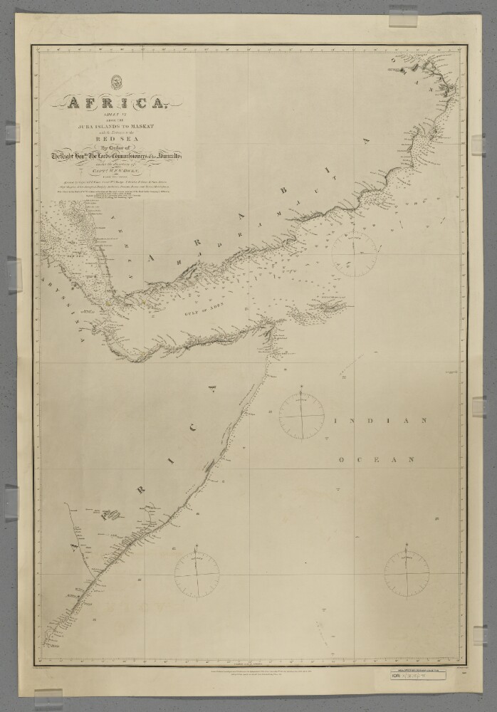
1. 'Africa, Sheet VI from the Juba Islands to Maskat with the Entrance to the Red Sea'
- Description:
- Abstract: Chart 598.Hydrographic chart covering the Horn of Africa north of the Juba [Bajun] Islands, the southern coast of the Arabian Peninsula to Maskat [Muscat], the western Indian Ocean, the Gulf of Aden and the southern Red Sea. Portrays hydrology, including depths by soundings and some contours, sands and rocks, relief by hachures and occasional spot heights, settlements and place names, and includes topographical notes and navigational aids, including lights highlighted in watercolour.Chart compiled under the direction of Captain William Fitzwilliam Owen from 1822 to 1826, assisted by Captain Alexander Thomas Emeric Vidal and lieutenants William Mudge, Thomas Boteler, Richard Owen, Edward Owen Johnes and Messrs Rogier, Arlett, Durnford, Badgley, Robinson, Bowen and Mercer, Midshipmen. North of 10°N the chart is compiled from reductions of more recent surveys by 'the East India Company's Officers'. Engraved by J & C Walker. Published by the Admiralty 1827, with corrections 1868, 1873, 1875, November 1876, December 1876, May 1877 and September 1877.Physical description: Materials: Printed, with watercolour additions, on paperDimensions: 870 x 600mm, on sheet 982 x 669mm
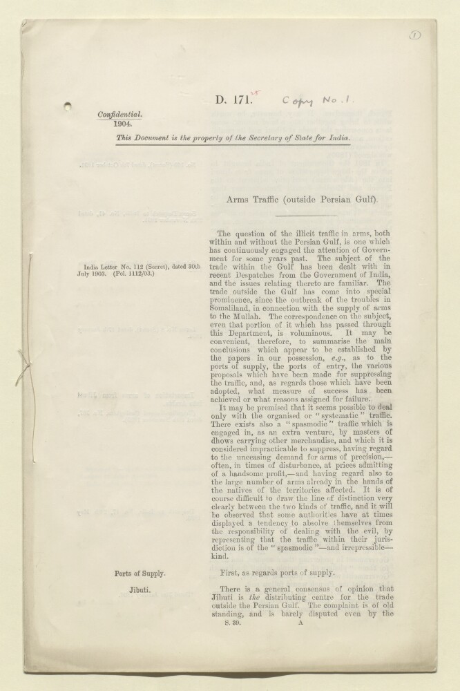
2. 'Arms traffic (outside Persian Gulf)'
- Description:
- Abstract: This file concerns arms traffic outside of the Persian Gulf. Specifically, the document discusses what it refers to as the 'spasmodic' illicit traffic of arms (as opposed to 'systematic' traffic) which has been carried out by masters of dhows carrying other merchandise. Most of the file is concerned with the traffic of arms from Jibuti [Djibouti] – which is referred to as ' thedistributing centre [original italics]' for the arms trade outside of the Persian Gulf – to ports in the Gulf of Aden.The document provides a brief history (from a British perspective) of traffic from Jibuti in the years since the signing of the Brussels Convention in 1890. It summarises, and provides references to, letters and despatches from a number of British authorities, which discuss various issues relating to the arms trade out of Jibuti, including: the extent to which traffic at Jibuti has been regulated; the possible threat that the traffic poses to the Aden garrison; the effects of measures taken by the French to curtail the traffic from Jibuti; other possible ports of supply, such as Zanzibar, Muscat and the Aden Protectorate ports.Also discussed are the attitudes of the maritime chiefs to the arms traffic, the various preventive measures available to the Resident at Aden for dealing with the effects of the traffic at Aden, an account of measures taken both by the British Somaliland authorities and by the Italian authorities, and an evaluation of the naval measures taken by the British since 1901. The file concludes by noting that one possible solution to the problem could be the deployment of armed dhows, a measure which previously has been advocated by the naval authorities, the Viceroy and the Resident at Aden.The document is attributed to P H D [P H Dumbell, Reading Clerk to the Council, India Office].Physical description: Foliation: the foliation sequence commences at the first folio and terminates at the last folio; these numbers are written in pencil, are circled, and are located in the top right corner of the recto side of each folio.Pagination: the file also contains an original printed pagination sequence.
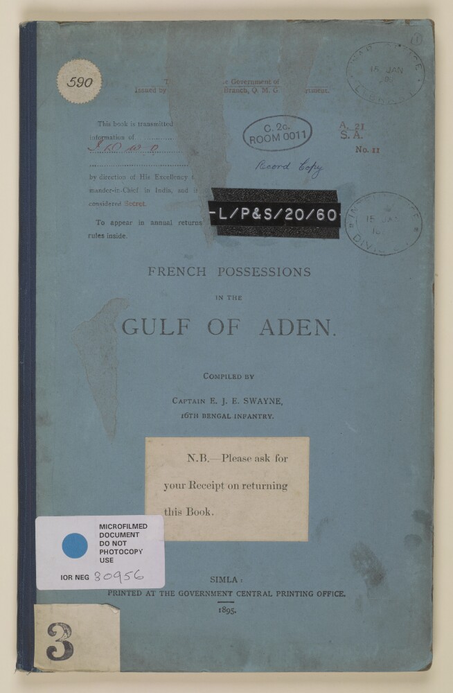
3. 'FRENCH POSSESSIONS IN THE GULF OF ADEN. COMPILED BY CAPTAIN E.J.E SWAYNE, 16TH BENGAL INFANTRY.'
- Description:
- Abstract: This volume consists of an intelligence document issued by the Government of India, Intelligence Branch, Quarter Master General's Department, which provides comprehensive descriptions of French possessions on the African coast of the Gulf of Aden, including the towns of Obok [Obock] and Jibouti [Djibouti]. The volume contains two maps held in a map pocket, and is divided into nine sections.The volume was compiled by Eric John Eagles Swayne, 16th Bengal Infantry. The printing statement reads, 'Simla: Printed at the Government Central Printing Office. 1895.'Two hand stamps appear on the front cover and on folio 5, which read, 'War Office Library 15 Jan 96' and 'Intelligence Division 15 Jan 1896'.Physical description: Foliation: the foliation sequence commences at the front cover with 1, and terminates at the inside back cover with 36; these numbers are written in pencil, are circled, and are located in the top right corner of the recto side of each folio.
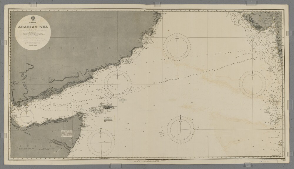
4. 'Arabian Sea'
- Description:
- Abstract: Chart 1012.Hydrographic chart covering the Arabian Sea, including the Gulf of Aden, between latitudes 7° 00' 00" N and 22° 32' 30" N. Includes the coastlines of the southern Arabian Peninsula, the Horn of Africa and parts of north-western India. Portrays hydrology, including depths by soundings and contours, some sands and rocks, relief by spot heights and hachures, vegetation, railways, settlements and place names, and includes buoys (highlighted in watercolour) and navigational notes.Eastern portion of the chart compiled by officers of the East India Government (1828-63); western portion by commanders Stafford Bettesworth Haines and I P Sanders [most likely John Parke Sanders] and lieutenants Albany Moore Grieve, Thomas Grere Carless, William Charles Barker and other officers of the Indian Navy (1836-49). Engraved by Malby & Sons. Published at the Admiralty 1899 with small corrections.Physical description: Materials: Printed, with additions in watercolour, on paperDimensions: 627 x 1173mm, on sheet 689 x 1231mm
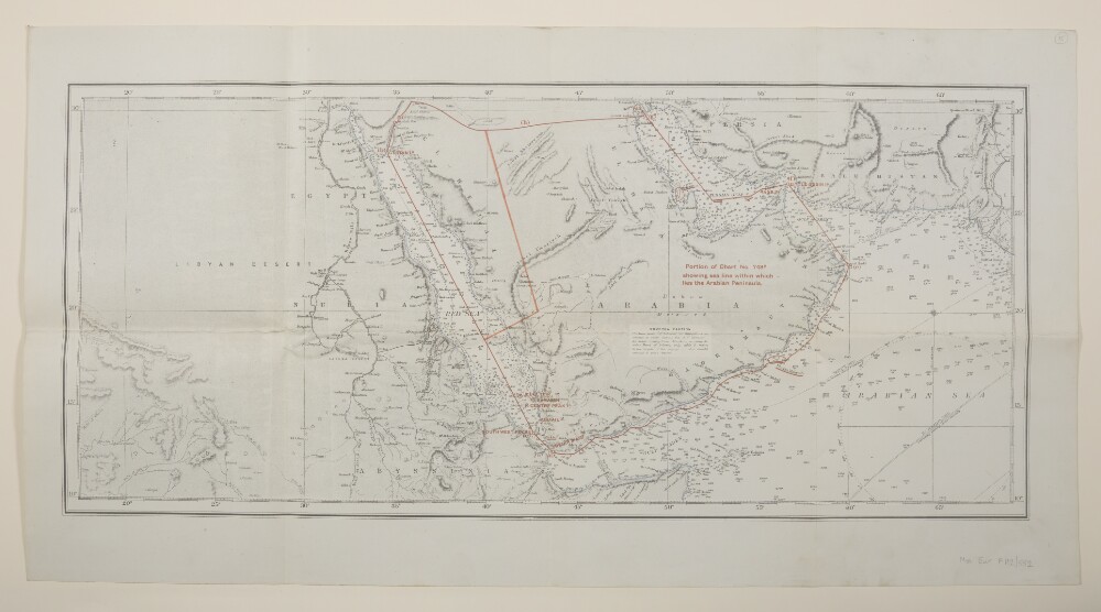
5. 'Portion of Chart No. 748B showing sea line within which lies the Arabian Peninsula.'
- Description:
- Abstract: Covers the Persian Gulf, Gulf of Aden and Red Sea, including hinterlands to a width of approximately 150 miles beyond which detail diminishes. Comprises a base map, overprint and manuscript additions.The base map is produced from British Admiralty Chart No. 748B titled 'Indian Ocean - Northern Portion' dated 15 November 1918 and filed at Maps B.A.C. (748B.). Portrays marine hydrology, including sands, rocks and depths by soundings, inland hydrology, relief by hachures and spot heights, railways, roads and tracks, settlements and place names. Bears the notes 'Drawn for engraving by E J Powell' and 'Engraved by Davies Bryer & Co.'A red overprint portrays the sea line including geographical reference points, some of which possess reference letters although no key is present.Manuscript additions relate to the sea line and also accentuate the coastline.The verso bears the annotation 'Arabia'.Physical description: Materials: Printed in colour, with manuscript additions in crayonDimensions: 290 x 676mm, on sheet 405 x 763mm
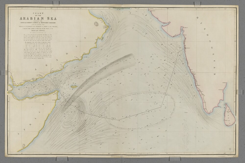
6. 'Chart of the Arabian Sea Shewing the Winds & Currents during the South-West Monsoon with the probably best Track for Steamers from Bombay to Aden in that Season.'
- Description:
- Abstract: Covers the Arabian Sea south of latitude 25°N, including the Gulf of Aden. Includes the coastlines of the Horn of Africa, the south-east Arabian Peninsula and the west coast of India. Includes a hinterland of approximately fifteen miles. Portrays hydrology, including rocks, relief by hachures, settlements, place names, and includes some navigational notes. Also shows meteorological information, including the strength and direction of currents and winds, surface water temperatures and sea turbulence, and includes meteorological notes and a suggested route for shipping between Aden and Bombay [Mumbai, India]. The chart has been enhanced with watercolour and some place names and routes added in pencil.Compiled by Lieutenant Alfred Dundas Taylor, Indian Navy. Engraved by J & C Walker. Published by John Walker, Geographer to the Honourable East India Company.Physical description: Materials: Printed, with manuscript additions in watercolour and pencil, on paper (backed with linen)Dimensions: 619 x 987mm, on sheet 654 x 1004mm
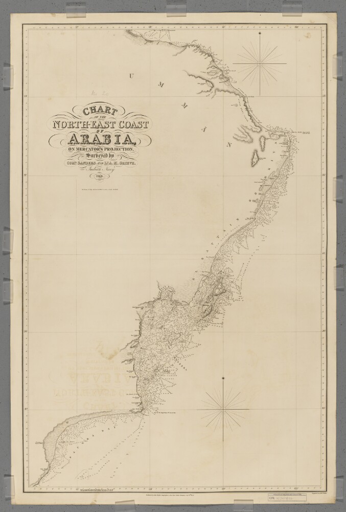
7. 'Chart of the North-East Coast of Arabia'
- Description:
- Abstract: Covers a 380-mile length of the Arabian Sea coast of Umman [Oman] from Ras Saugra [Ra's Sawqirah] north-eastwards to Ras el Hadd [Ra's al Hadd], and then a 150-mile length of the Gulf of Aden coast north-westwards to Muskat [Muscat]. Includes a hinterland of approximately twenty miles. Portrays hydrology, including depths by soundings and some contours, relief by spot heights, hachures and rock drawing, sand dunes, vegetation, settlements, tribal lands and place names, and includes topographical and hydrographic notes.Surveyed by Commander I P Sanders [most likely John Parke Sanders] and Lieutenant Albany Moore Grieve, Indian Navy. Engraved by J & C Walker. Published by John Walker, Geographer to the East India Company.Physical description: Materials: Printed on paper (backed with linen)Dimensions: 941 x 604mm, on sheet 1011 x 673mm
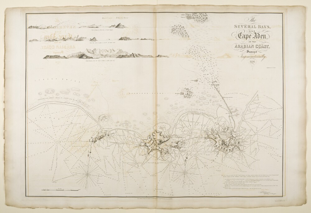
8. ‘The Several Bays near Cape Aden, on the Arabian Coast, surveyed Trigonometrically, 1836. Engraved by J.&C. Walker’
- Description:
- Abstract: Imprint:Published by John Walker, Geographer to the Honourable East India Company.Distinctive Features:Relief shown by hachures and spot heights. Depths shown by soundings.Nautical chart of the coast of the Gulf of Aden compiled from the surveys carried out by the Bombay Marine’s officers between 1820 and 1829. Includes three marginal coastal profiles showing ‘Bunder Fuggum’, ‘Bunder Sheik’, and ‘Gibbul Shumsan from the vessel at anchor in Aden eastern bay’.Contains a descriptive note signed by Stafford Bettesworth Haines listing names of surveyors with remarks on latitude and longitude observations and details on water levels.Physical description: Dimensions:618 x 865 mm, on sheet 678 x 1018 mm
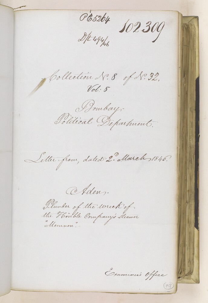
9. ‘Aden. Plunder of the wreck of the Honble Company’s steamer “Memnon”.’
- Description:
- Abstract: The item consists of copies and extracts of correspondence and minutes, which form partial enclosures to a letter from the Government of Bombay [Mumbai] to the East India Company Court of Directors, dated 2 March 1846. A copy of this letter can be found at IOR/F/4/2142/102302, alongside details of further enclosures.The item relates to an update provided by Stafford Bettesworth Haines, Captain in the Indian Navy and Political Agent at Aden, to the Government of Bombay regarding the investigation into property stolen from the wreck of the Company’s schooner, Memnon. Haines provides details on the main suspect, Ali Yusuf, Chief of Aloola [‘Alī Yūsuf, Chief of Caluula], and recommends a course of action for obtaining compensation. His update is forwarded on to the Government of India for instruction.Aloola is also rendered in the text as ‘Alloola’.As well as Haines and the Government of Bombay, the item’s correspondents also include the Court of Directors.The title page of the item contains the following references: ‘Bombay Political Department’, ‘P.C. [Previous Communication] 5264, Draft 494/46’, ‘Collection N. 8 of N. 32, Vol: 8’ and ‘Examiner’s Office’.Physical description: Foliation: the foliation sequence for this description (used for referencing) commences at f 198, and terminates at f 203, as it is part of a larger physical volume; these numbers are written in pencil, are circled, and are located in the bottom right corner of the recto side of each folio.Pagination: the item also contains an original pagination sequence.

10. Aden Affairs
- Description:
- Abstract: This item comprises copies of enclosures to a despatch from the Government of Bombay Secret Department to the Secret Committee, Number 26 of 1847, dated 15 March 1847. The enclosures are dated 4 January-13 March 1847.The item chiefly comprises communications between Stafford Bettesworth Haines, Political Agent at Aden; the Secretary to the Government, Bombay; and the Secretary to the Government of India. Also included are several minutes of the President and Governor in Council, Bombay, concurred with by members in Council or the Board.The papers cover the following matters:The general peaceful state of affairs in the vicinity of Aden and the resulting good communications with the interior and well stocked marketsReports that the Imam of Sana [Sana‘a ] has marched to Taaez [Taiz, also spelled Taez in this item] since the Sherriff [Sharif] of Mocha has made peace with Sheik Ali Homeida [Shaikh ‘Alī Ḥumaydah], that he is levying contributions from the ‘mountain chiefs’, and that his force is reputedly 7000 men strongAffairs concerning the tribes of the neighbourhood, including: a recent disturbance between a number of tribes caused by a ‘misunderstanding concerning transit duties’ (f 574); and an apparent attack by the Azeibies [‘Uzaybī?] on Futhel ibn Hyder [Faḍl bin Ḥaydar] of Seyla and his return attackA report that the Sultan of the Ourlghi tribe has issued orders for his tribe to march westward, causing great concern to the ‘agriculturists’ (farmers) surrounding Lahidge [Lahej] and the Sultan of Lahidge, and Haines’s hope that an invasion will not happen as this would affect the Aden marketThe return to Aden of the HC [Honourable Company’s] Schooner of War Constancefrom Mussowah [Massawa, also spelled Mussowa in this item] and a copy of the commander’s report to Haines (ff 592-594), of his proceedings regarding settlement of the dispute between the Banian merchant and the Turkish [Ottoman] Governor of Mussowah to the satisfaction of both parties. Also included is Haines’s justification for sending the Constanceto Mussowah (f 599), following a request for further particulars from the Bombay GovernmentHaines’s report that he has requested the HC Schooner Tigristo convey Lieutenant Charles John Cruttenden, Assistant Political Agent at Aden, on a tour around the different ports and within the gulf of Aden, whom he has instructed, amongst other things, to: proceed to Berbera and Bulharr [Bulhar] to visit the ‘feuding’ Somali tribes on the African coast and to persuade the Elders into amicable settlements since the feuds are impeding the coastal trade with Aden; investigate obtaining supplies from Maculla [Makalla] in case of an emergency; obtain the property of the late Reverend Thomas Brochman at Shahr [ash-Shihr]; visit Socotra to enquire into the movement of French vessels which have apparently surveyed the island in detail recently; and enquire into the trade in enslaved persons in the region (ff 587-589)The view of the Governor-General of India that the stipend of the Sultan of Lahidg should be forfeited as he was the ‘leader and fomenter of the recent hostilities at Aden’, and should only be renewed after ‘a period of approved good conduct’ (f 581)Soundings taken, by the commander of the Constance, on two sides of the Zebaya [Zubayr] Islands and confirmation that no change in the depth of water there has been found (subsequent to the recent volcanic eruption there) (f 597)The ‘Proposed Draft of Instructions for the guidance of the Political Agent at Aden’ (ff 607-609) regarding police rules, and their transmission to Haines to report how far, in his opinion, they can be made applicable to AdenIn response to Haines’s request for instructions, the Bombay Government’s agreement that the Johannese Chiefs [ruling princes of Anjouan] who are expected to return to Aden next July should be entertained at government expense, but that Haines should arrange a ‘Bugla, or other country craft’ (f 613) to return them to their country as there is no justification for using a government vessel.Physical description: 1 item (45 folios)
11. Board's Collections Vol 649
- Description:
- Abstract: This volume consists of two items which are copies of correspondence, minutes, and memoranda cited in, or enclosed with, letters to and from the Government of Bombay. The items are:IOR/F/4/649/17851 'Proceedings adopted in consequence of the depredations committed by the Joasmee [al-Qāsimī] Pirates in the Persian Gulph [Gulf]', Vol. 2IOR/F/4/649/17852 'Proceedings adopted in consequence of the depredations committed by the Joasmee Pirates in the Persian Gulph', Vol. 3.Physical description: Foliation: the foliation sequence (used for referencing) commences at the inside front cover with 1, and terminates at the inside back cover with 371; these numbers are written in pencil, are circled, and are located in the bottom right corner of the recto side of each folio.Pagination: the volume also contains an original pagination sequence.
12. Coll 6/20 'Red Sea: Reports of proceedings of H.M. Ships.'
- Description:
- Abstract: This file consists of copies of extracts from (approximately) monthly reports of the proceedings of His Majesty's ships in the Red Sea and the Gulf of Aden during the years 1931-1945, which have been forwarded by the Admiralty to the Under-Secretary of State, India Office.Most of the extracts are attributed to the Senior Officer of the Red Sea Sloops, the Commander-in-Chief of Mediterranean Station, or commanding officers of particular British ships. Prominently featured ships include the following: HMS Lupin, HMS Penzance, HMS Londonderry, and HMS Weston.The extracts vary in their range of subject matter. Some of the extracts are largely concerned with local affairs along the Yemeni coast; others report on matters relating to the region as a whole, such as Saudi-Yemeni relations.Matters discussed in the extracts include the following:The slave trade.The transportation of a British medical mission to Yemen in December 1931, headed by a female doctor named P W R Petrie, for the purpose of treating the Imam of Yemen's [Yaḥyá Muḥammad Ḥamīd al-Dīn's] granddaughter.The passage of pilgrims through Kamaran.A visit by the Chief Commissioner of Aden [Bernard Rawdon Reilly] to Abd el Kuri [Abd al Kuri] and Socotra, on board HMS Penzance, in 1933.The presence of Saudi forces in Asir.Relations between Ibn Saud [‘Abd al-‘Azīz bin ‘Abd al-Raḥmān bin Fayṣal Āl Sa‘ūd] and the Imam of Yemen.The Saudi-Yemeni conflict of 1934, including details of the evacuation of Yemeni troops from Hodeida [Al Ḩudaydah] and the subsequent entry of Saudi troops.Italian naval posts in the Red Sea.Yemeni concerns that Italy, following on from events in Abyssinia, might also become aggressive towards Yemen.The importance of Kamaran as a Red Sea trading port.Details of a special arms patrol carried out by HMS Westonin the Gulf of Akaba [Aqaba] in 1938.The correspondence concludes with a copy of an intelligence report of the Red Sea area, dated 17 October 1945 and produced by the Naval Intelligence Centre, Levant and East Mediterranean.In addition to report extracts, the file includes a small sketch map of the Aden Protectorate and the surrounding area.The file includes two dividers which give a list of correspondence references contained in the file by year. These are placed at the back of the correspondence.Physical description: Foliation: the foliation sequence for this description commences at the inside front cover with 1, and terminates at the last folio with 246; these numbers are written in pencil, are circled, and are located in the top right corner of the recto side of each folio. An external leather cover wraps around the documents, the front inside of which has been foliated as folio 1. An additional foliation sequence is present in parallel between ff 2-245; these numbers are also written in pencil but are not circled.
- « Previous
- Next »
- 1 Current Page, Page 1
- 2