Number of results to display per page
Search Results
13. 'Arabia. Political Situation in Nejd'
- Description:
- Abstract: This printed report contains a memorandum by Major Harold Richard Patrick Dickson, Political Agent, Bahrein [Bahrain], dated 12 August 1920, concerning the political situation in Nejd [Najd] and Central Arabia at the end of July 1920, gathered from conversations with Abdul Aziz Al Qusaibi [‘Abd al-‘Azīz al-Quṣaybī], the agent at Bahrain of Bin Saud [‘Abd al-‘Azīz bin ‘Abd al-Raḥmān bin Fayṣal Āl Sa‘ūd, Ibn Saud]; Fahad Al Bassam [Fahad Āl Bassām], merchant of Qassim [al-Qaṣīm] and Hassa [al-Aḥsā’]; Muhammad Al Hawwas [Muḥammad Āl Ḥawwās], merchant of Riyadh and Hassa; and Bedouin visitors from Bani Hajar [Banī Hājir], Bani Khalid [Banī Khālid], Dawasir [al-Dawāsir] and other tribes. The note primarily focuses on Ibn Saud's relations with Ibn Rashīd.Physical description: Foliation: The foliation for this sequence commences at folio 131, and terminates at folio 134, as it is part of a larger physical volume; these numbers are written in pencil, are circled, and are located in the top right corner of the recto side of each folio. An additional foliation sequence is also present in parallel between folio 7-153 of the volume; these numbers are also written in pencil, but are not circled, and can be found in the same position as the main sequence.
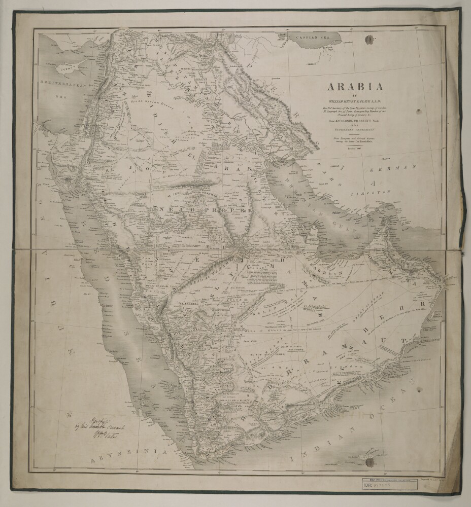
14. ‘Arabia. By William Henry F. Plate’
- Description:
- Abstract: Imprint:London, engraved by J.&C. Walker.Distinctive Features:Title continues: ‘L.L.D. Honourable Foreigner Secretary of the Syro-Egyptian Society of London. M. Geographical Society of Paris. Corresponding Member of the Oriental Society of Germany &c. Drawn for Colonel Chesney's work on his Euphrates expedition’'From European and Oriental sources; among the latter Ibn Khordadbeh'.Relief shown by hachures.Notations concerning the regions and topography, pilgrim routes, tribes cover the face of the map.Inscriptions:On recto in the left-hand corner: ‘To [illegible] by his humble servant Wm. Plate’.Physical description: Dimensions:645 x 600 mm

15. 'Arabia. Question of Future Policy, Subsidies to Chiefs, &c'
- Description:
- Abstract: This printed report consists of two notes prepared by Richard Marrs and John Evelyn Shuckburgh of the Political Department of the India Office on 19 October 1920 and 29 October 1920 respectively. These notes concern British policy, including the payment of subsidies and grants-in-aid, towards political leaders in the Arabian Peninsula, including Ibn Sa'ud [‘Abd al-‘Azīz bin ‘Abd al-Raḥmān bin Fayṣal Āl Sa‘ūd], Ibn Rashid [‘Abdullāh bin Mut‘ib Āl Rashīd], and the Sharif of Mecca, Hussain [Ḥusayn bin ‘Alī al-Hāshimī], and his son Faisal [Fayṣal bin Ḥusayn al-Hāshimī], and the Idrisi amir of Asir.Physical description: Foliation: The foliation for this description commences at folio 149 and terminates at folio 150, as it is part of a larger physical volume; these numbers are written in pencil, are circled, and are located in the top right corner of the recto side of each folio. An additional foliation sequence is also present in parallel between folios 7-147 of the volume; these numbers are also written in pencil, but are not circled, and can be found in the same position as the main sequence.

16. 'Arabia: The Nejd-Hejaz Feud'
- Description:
- Abstract: This is a note by John Evelyn Shuckburgh of the Political Department, India Office, dated 7 January 1919, concerning relations between Bin Saud [‘Abd al-‘Azīz bin ‘Abd al-Raḥmān bin Fayṣal Āl Sa‘ūd] of Nejd [Najd] and King Hussain [Ḥusayn bin ‘Alī al-Hāshimī] of the Hejaz [al-Ḥijāz], specifically the dispute between them over the village of Khurma [al-Khurmah]. The note includes two appendices: 'Appendix I: Bin Saud's Claim to Khurmah (Extract from Memorandum by Mr [Harry St John Bridger] Philby, dated 13th August 1918)' and 'Appendix II: The Alleged Treaty Between Bin Saud and the Sherif'.Physical description: Foliation: The foliation for sequence for this file commences at folio 11, and terminates at folio 13, as it is part of a larger physical volume; these numbers are written in pencil, are circled, and are located in the top right corner of the recto side of each folio. An additional foliation sequence is also present in parallel between folios 7-153; these numbers are also written in pencil, but are not circled, and can be found in the same position as the main sequence.
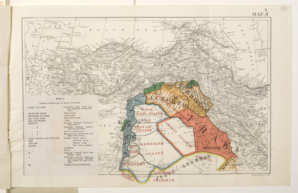
17. 'Map 3. Possible Settlement of Arab Countries.'
- Description:
- Abstract: Map forms a part of Mss Eur F112/570, ff 17-23.The title and legend are printed on a small paper sheet that has been pasted over the south-west corner of the map. The map number '1' has been deleted and replaced by '3'. Map portrays hydrology, relief by spot heights and hachures, roads and tracks, railways, submarine telegraph lines, settlements, place names and international boundaries. Map also depicts, by variously coloured shading and lettering, possible settlement arrangements of Arab countries, incorporating a range of ethnological categories. Bears the imprint 'London: Edward Stanford, 12, 13 & 14, Long Acre, W.C.' [Published by the Political Intelligence Department, Foreign Office, 21 November 1918.]Another copy of this map is at Mss Eur F112/570, f 29.Physical description: Materials: Printed in colourDimensions: 258 x 388mm, on sheet 288 x 450mm
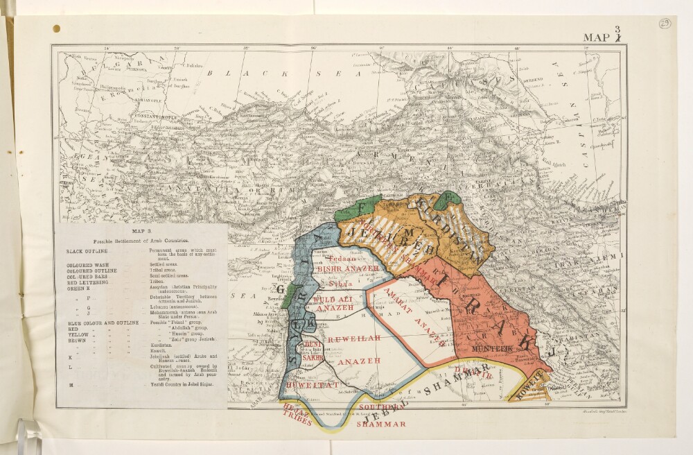
18. 'Map 3. Possible Settlement of Arab Countries.'
- Description:
- Abstract: Map forms a part of Mss Eur F112/570, ff 24-30.The title and legend are printed on a small paper sheet that has been pasted over the south-west corner of the map. The map number '1' has been deleted and replaced by '3'. Map portrays hydrology, relief by spot heights and hachures, roads and tracks, railways, submarine telegraph lines, settlements, place names and international boundaries. Map also depicts, by variously coloured shading and lettering, possible settlement arrangements of Arab countries, incorporating a range of ethnological categories. Bears the imprint 'London: Edward Stanford, 12, 13 & 14, Long Acre, W.C.' [Published by the Political Intelligence Department, Foreign Office, 21 November 1918.]Another copy of this map is at Mss Eur F112/570, f 22.Physical description: Materials: Printed in colourDimensions: 258 x 388mm, on sheet 288 x 450mm
19. 'Persian Gulf - Turkish jurisdiction along the Arabian coast (Part I)'
- Description:
- Abstract: A memorandum, written by Adolphus Warburton Moore, Assistant Secretary of the Political and Secret Department of the India Office, 1 September 1879.The document is a summary of correspondence, government reports, and published literature relating to the Turkish expedition into El Hassa [Al Hasa] in 1871, and was compiled in light of a proposed comprehensive arrangement with the Porte about the positions of the two powers along the Gulf coast, and policing responsibilities at sea. The correspondence is from the period 1870-1874 and is principally between various British Government departments and offices connected to the region, and the Turkish Government.The Turkish expedition called into question the sovereignty and jurisdiction of much of the Arabian Peninsula, as well as the coastline and islands of the Gulf. The correspondence contains discussions of these matters and reflects British fears of a loss of their monopoly over the control and security of the Gulf, and a disruption of the treaty relations they maintained with rulers in Bahrein [Bahrain], Guttur [Qatar], the Trucial Coast, Muscat, and Aden.The author quotes extensively from the correspondence and other sources, notes on which are to be found in the margin throughout.Physical description: Foliation: the foliation for this description commences at folio 131 and terminates at folio 144, as it is part of a larger physical volume; these numbers are written in pencil, are circled, and are located in the top right corner of the recto side of each folio. The main foliation sequence commences at the front cover, and terminates at the back cover; these numbers are written in pencil, are circled, and are located in the top right corner of the recto side of each folio.Pagination: The volume also contains an original printed pagination sequence.Condition: folio 131 is torn along one edge, with some loss of text.

20. 'Persian Gulf - Turkish jurisdiction along the Arabian coast (Part II)'
- Description:
- Abstract: A memorandum, written by Adolphus Warburton Moore, Assistant Secretary of the Political and Secret Department of the India Office, 1 September 1879.The document is a continuation of 'Persian Gulf - Turkish jurisdiction along the Arabian coast (Part I)' (IOR/L/PS/18/B19/1) and broadly addresses the same issues, namely, what to do about Turkish claims to sovereignty along the southern coast of the Gulf that could potentially impinge on Britain's treaty commitments with local rulers and their security responsibilities at sea (the suppression of piracy), and whether to come to some kind of comprehensive arrangement with the Ottoman Government to settle the matter. To support this, the document gives a history of recent affairs in the region, making extensive use of correspondence and memoranda mostly written between 1874 and 1879. The principal correspondents are from the Government of India, the Foreign Office, the India Office, and various political and diplomatic offices in the Persian Gulf, Turkish Arabia, and Constantinople. The matters covered by the document concern events at Bahrein [Bahrain], Guttur [Qatar] - including Zobarah [Al Zubarah], Odeid [al-‘Udaid], and El Bidaa [Doha] - Lahsa [al-Hasa], and the Trucial states.The memorandum concludes by outlining the position of the Foreign Office, the Government of India, and the India Office (represented by the author) on the following four matters:1. The status of Odeid;2. The need to better define areas of responsibility and jurisdiction with the Porte, and whether to hold them responsible for order along the coast under their authority;3. A revision of Britain's treaties with Bahrain, the Trucial chiefs, and Muscat;4. The arrangement of Persian Gulf business between the Bushire Residency and the Baghdad Political Agency.The author quotes extensively from the correspondence and other sources, notes on which are to be found in the margin throughout.Physical description: Foliation: The foliation for this description commences at folio 148 and terminates at folio 168, as it is part of a larger physical volume; these numbers are written in pencil, are circled, and are located in the top right corner of the recto side of each folio. The main foliation sequence commences at the front cover, and terminates at the back cover; these numbers are written in pencil, are circled, and are located in the top right corner of the recto side of each folio.Pagination: The volume also contains an original printed pagination sequence.
21. ‘Persian Gulf’
- Description:
- Abstract: The item consists of seven letters from the Government of Bombay to the East India Company Court of Directors. The letters refer to general updates from the Persian Gulf and surrounding regions between August 1852 and February 1853. It is the first in a series of sixteen items on events in the Gulf.The first letter is dated 31 August 1852 and is present at folio 1082. Enclosures can be found at IOR/F/4/2504/142186.The second letter is dated 2 October 1852 and is present at folio 1083. Enclosures can be found at IOR/F/4/2504/142187.The third letter is dated 3 November 1852 and is present at folio 1084. Enclosures can be found at IOR/F/4/2504/142188.The fourth letter is dated 3 November 1852 and is present at folio 1085. Enclosures can be found at IOR/F/4/2504/142189.The fifth letter is dated 3 December 1852 and is present at folios 1086-1087. Enclosures can be found at:IOR/F/4/2504/142190IOR/F/4/2504/142191IOR/F/4/2504/142192IOR/F/4/2504/142193.The sixth letter is dated 13 January 1853 and is present at folios 1088-1089. Enclosures can be found at:IOR/F/4/2504/142194IOR/F/4/2504/142195IOR/F/4/2504/142196IOR/F/4/2504/142197IOR/F/4/2504/142198IOR/F/4/2504/142199IOR/F/4/2504/142200.The seventh letter is dated 11 February 1853 and is present at folio 1090.The sixth letter contains a short quotation from a letter, dated 21 January 1852, from the Court of Directors to the Government of Bombay.The title page of the item contains the following references: 'Bombay Political Department', 'Draft No. 350 of 1853', 'Collection N 1 (In 16 Volumes) & 3 Supplementary Vols:', 'Vol: 1', and 'Examiner's Office'.Physical description: Foliation: the foliation sequence for this description (used for referencing) commences at f 1080, and terminates at f 1090, as it is part of a larger physical volume; these numbers are written in pencil, are circled, and are located in the bottom right corner of the recto side of each folio.Pagination: the item also contains an original pagination sequence.
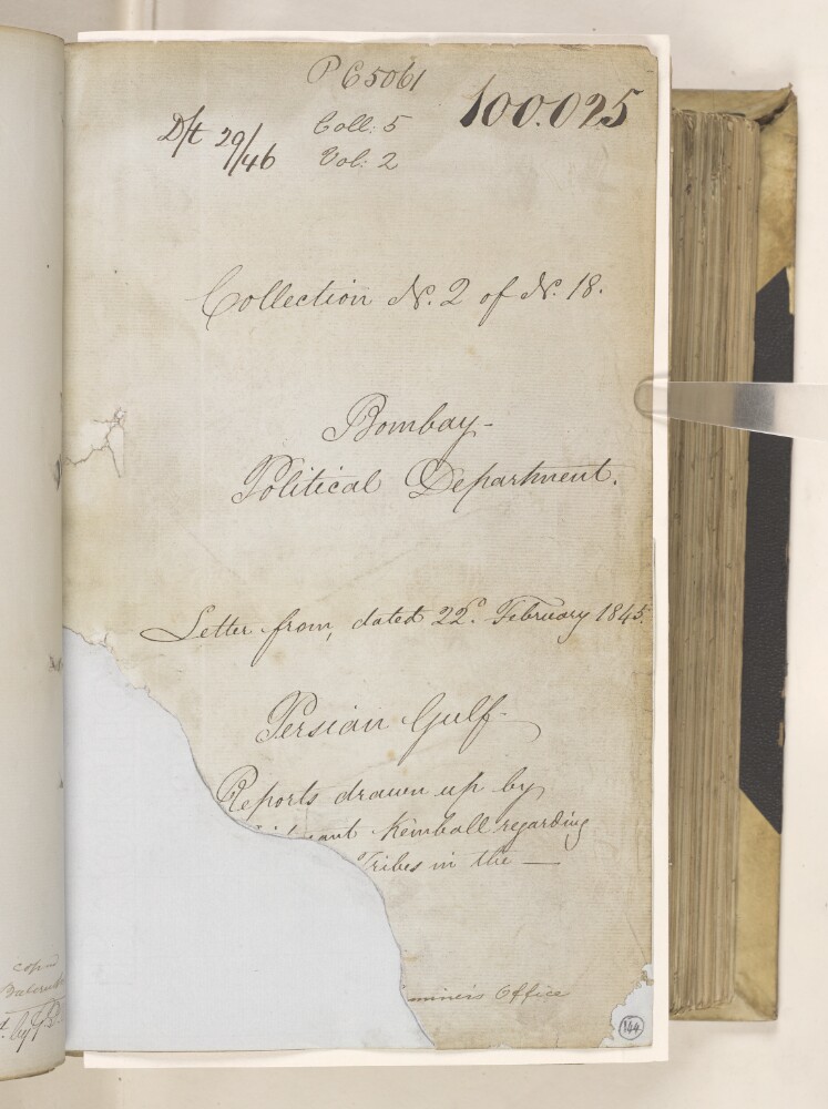
22. ‘Persian Gulf. Reports drawn up by Lieutenant Kemball regarding [] tribes in the - .’
- Description:
- Abstract: This item consists of copies of correspondence, minutes, and consultations cited in, or enclosed with, a political letter from the Government of Bombay [Mumbai]. The correspondents are the Government of Bombay and Captain (later Major) Samuel Hennell, Resident in the Persian Gulf.The item concerns a request by the Government of India for a report on the history of Britain’s relations with the states on the Arabian coast of the Persian Gulf, and the completion of this by Lieutenant Arnold Burrowes Kemball, Assistant Resident in the Persian Gulf. Kemball’s report was originally submitted with the political letter. The first part can be found in IOR/F/4/2121/100024, and the remainder is included in this item. An additional report on the territories belonging to the Imam of Muscat, produced by Captain Atkins Hamerton and also submitted with the political letter, is contained in IOR/F/4/2121/100026.This item contains the following sections of Kemball’s report:‘Historical Sketches of the Arab Tribes in the Persian Gulf from 1832 to 1844.’‘Chronological Table of Events connected with the Arab Tribes of the Persian Gulf being an Index to the Historical Sketches of those tribes.’‘Memoranda on the resources, localities and relations of the Tribes inhabiting the Arabian Shores of the Persian Gulf.’These sections contain Kemball’s summaries and commentary, as well as extracts from earlier records produced by British officials.The item contains a table of contents (f 145), and the title page (f 81) contains the following references: ‘P C [Previous Communication] 5061, Coll. 5, Vol. 2’, ‘D/t 29/46’, ‘Collection No. 2 of No. 18’ and ‘Examiner’s Office’.Physical description: Foliation: the foliation sequence (used for referencing) commences at the first folio with f 144 and terminates at f 329, as it is part of a larger physical volume; these numbers are written in pencil, are circled, and are located in the bottom right corner of the recto side of each folio.Pagination: the volume also contains an original pagination sequence.Condition: Part of f 144 is missing, which has resulted in some of the text being lost.
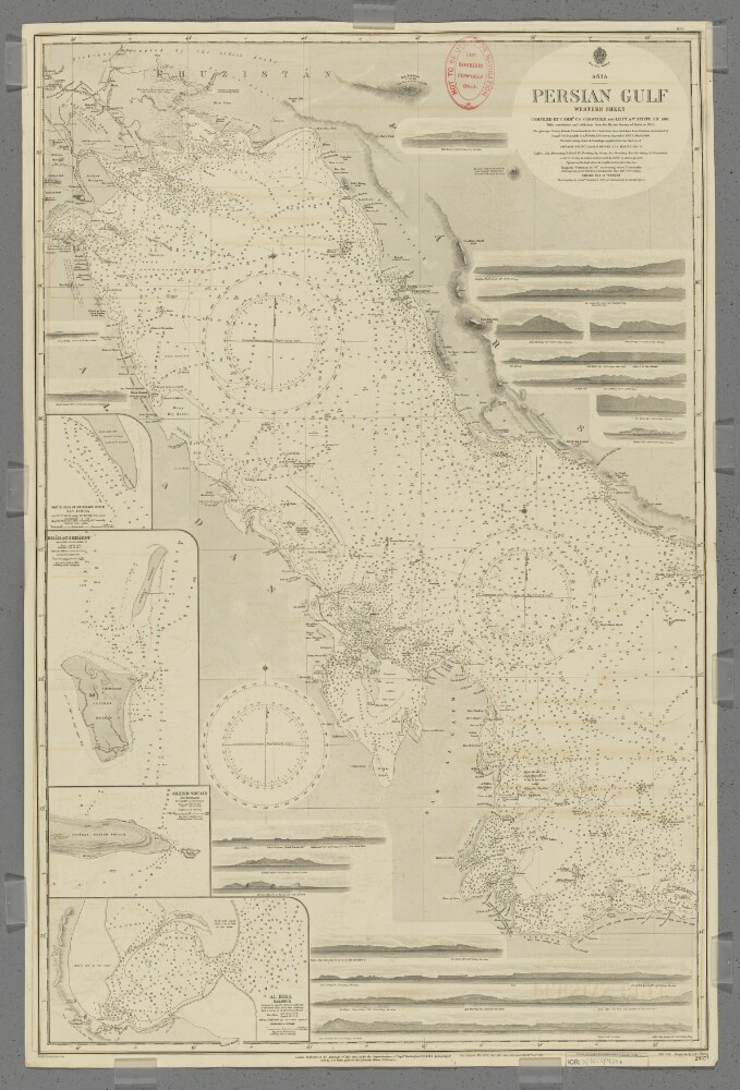
23. 'Persian Gulf. Western Sheet'
- Description:
- Abstract: Chart 2837b.Hydrographic chart covering the Persian Gulf from Al Basra, Mesopotamia [Al Basrah, Iraq] westwards to approximately longitude 53° 20’E. Also includes the adjacent coastal areas of Persia [Iran], Mesopotamia and the eastern Arabian Peninsula. Portrays hydrology, including depths by soundings and contours, anchorages, sands and rocks, relief by spot heights, hachures and rock drawings, vegetation, settlements, forts and place names, and includes topographical notes and navigational aids, including lights and prominent landmarks.Includes insets of Ras Tanura, Arabia [Ras Tannurah, Saudi Arabia] at scale 1:18,360; Kharag [Kharg] & Khargu, Persia [Iran] at scale 1:72,913; Henjam Sheikh Shu'aib, Persia [Lavan Island] at scale 1:121,520; and Al Bida, Al Katr [Al Bid', Qatar] at scale 1:60,760.Eighteen annotated sketches of significant navigational views at unspecified scales on both the north and south coasts are also included.Chart surveyed and compiled by Commander Charles Golding Constable and Lieutenant Arthur William Stiffe, Indian Navy (1860); also incorporates surveys by Captain John Michael Guy and Captain George Barnes Brucks, East India Marine (1821-29); with corrections and additions from the Marine Survey of India to 1911. Engraved by J & C Walker. Published at the Admiralty 1862, with new editions 1876, 1890, 1900, 1903 and 1912, and small corrections.The sheet bears the stamps:'Not to be used for navigation. For reference purposes only' in red on the map face.The number '30.2' in black in the upper right margin.Physical description: Materials: Printed on paperDimensions: 964 x 622mm, on sheet 1020 x 666mm

24. 'Policy in Arabia'
- Description:
- Abstract: This printed memorandum is a note, dated 20 November 1918, by Sir Frederic Arthur Hirtzel of the India Office concerning British policy in Arabia. The note discusses 'The Status of the King of the Hejaz [Ḥusayn bin ‘Alī al-Hāshimī]' and 'The Status of Iraq', and largely focuses on British interests in Mesopotamia [Iraq]. The policy note makes it clear that Britain’s main objective was to gain control of the whole of Mesopotamia.Physical description: Foliation: The foliation for this description commences at folio 133 and terminates at folio 134, as it is part of a larger physical volume; these numbers are written in pencil, are circled, and are located in the top right corner of the recto side of each folio. An additional foliation sequence is also present in parallel between folios 11-158; these numbers are also written in pencil, but are not circled, and can be found in the same position as the main sequence.