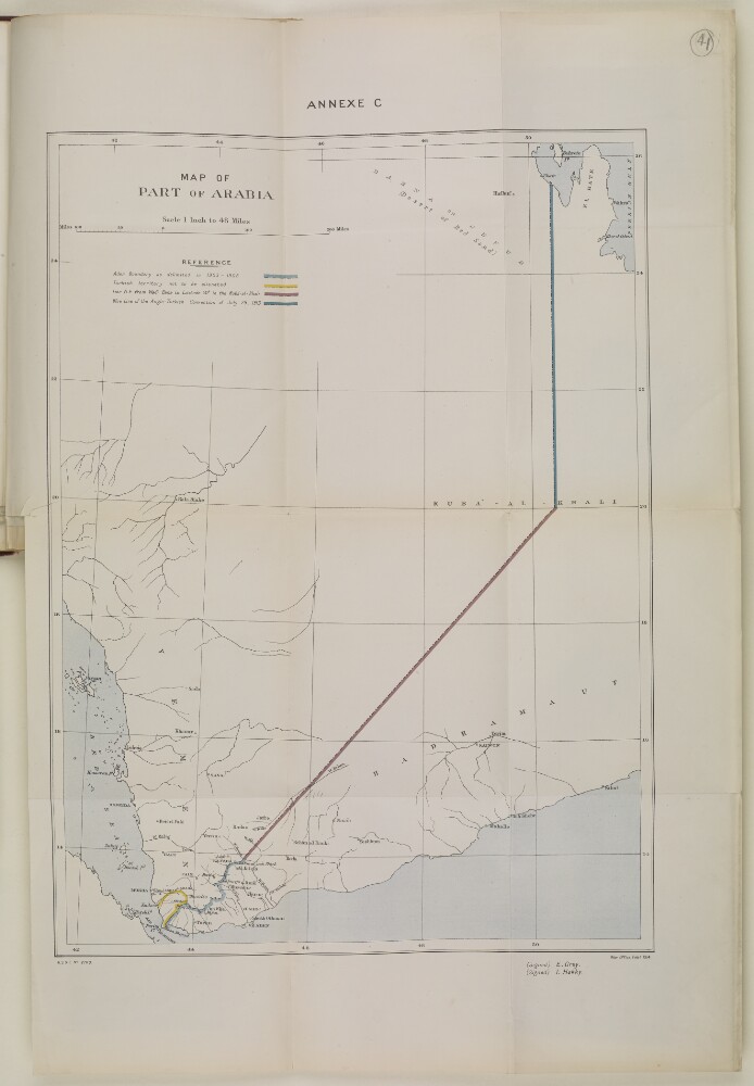
Abstract: Imprint:War Office, Feb.y 1914, G.S.G.S. No. 2709. Signed by Sir Edward Grey and Ibrahim Hakki Pasha.Distinctive Features:Issued as an Annex C to Anglo-Ottoman Convention of 3 June 1914 with boundaries shown in colour. Includes a key in the upper left, below title.Physical description: Dimensions:496 x 360 mm, on sheet 663 x 445 mm
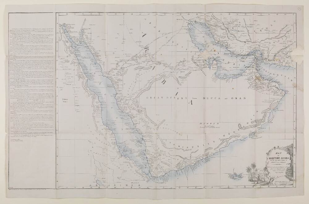
Abstract: Sheet 1 (Eastern) bears the shelfmark IOR/X/3635/1Sheet 2 (Western) bears the shelfmark IOR/X/3635/2Covers the Persian Gulf, Strait of Hormuz and the coastlines of Persia [Iran], Mesopotamia and the north-eastern Arabian Peninsula eastwards to the Musandam Peninsula. Includes a hinterland of approximately twelve miles. Portrays hydrology, including depths by soundings, and rocks, relief by hachures and rock drawing, vegetation, settlements and place names in English and Arabic, and includes topographical and hydrographic notes. The coastlines are highlighted in watercolour.'Constructed from the Trigonometrical Surveys. Made by Order of the Hon[ourab]le the Court of Directors of the United English East India Company; and to whom it is Respectfully Dedicated by their most obedient Servant George Barnes Brucks, Commander HC [Honourable Company] Marine. 1830.'Original surveys by Lieutenants John Michael Guy, George Barnes Brucks, Robert Cogan, William Eales Rogers and Stafford Bettesworth Haines, 1821-29. Engraved by Richard Bateman. Published by James Horsburgh, Hydrographer to the Honourable East India Company, 1832.Physical description: Materials: Printed, with manuscript additions in watercolour, on paper (backed with linen)Dimensions: Sheet 1 (Eastern) 725 x 580mm, on sheet 803 x 644mm; Sheet 2 (Western) 731 x 580mm, on sheet 820 x 648mm
Abstract: Imprint:Lithographed in the Chief Engineer's Office by E Huskeljee and E Kumroodeen, Bombay.Distinctive Features:Relief shown by hachures.Below the title note 'reduced in the Quarter Master Generals Office from an Original Map by Colonel T Dickinson, Chief Engineer. Signed Neil Campbell, Lieutenant-Colonel, Acting Quarter Master General'.A detailed explanation of the various surveys, expeditions and engraved charts used to compile the map from 1819 to 1839 is given along with descriptions of the various routes shown on the map, and others which were referred to in the compiling of this map. The description was compiled by the Chief Engineers Office, Bombay, 4 April 1843.Those routes represented on the map are as follows: Shows in blue lines the routes of the pilgrims from Medina to Tsha Haffar 35 days journey; the Persian caravan from Bussora to Mecca 30 days journey; and the Indian caravan from Lahsa to Mecca. Shown in red dotted line the route from El Katif to Yamboo as taken by Captain Sadlier in 1819. Coastlines are marked with blue ink and all bodies of water have been shaded in blue.Physical description: Dimensions:522 x 728 mm; on sheet 595 x 925 mmCondition:The map has incurred some damage from being folded, with some small areas of detail now lacking where the fold lines are.Foliation:The map has been foliated in the top right hand corner of the folio with a pencil number enclosed in a circle.
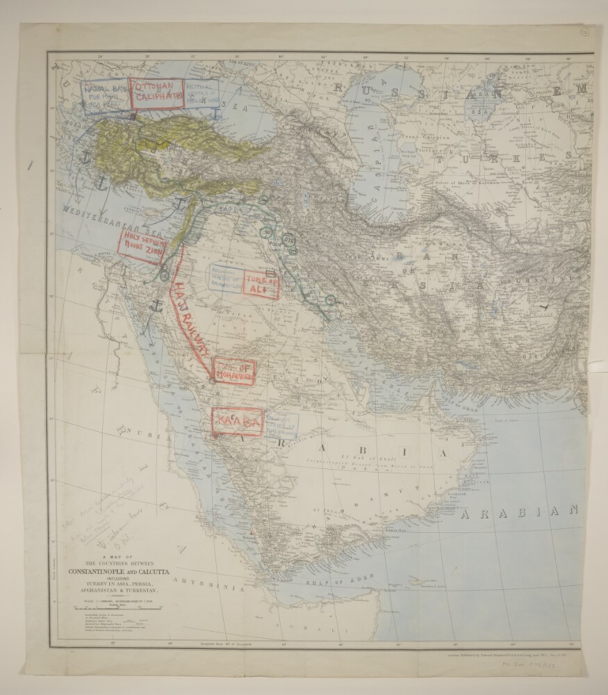
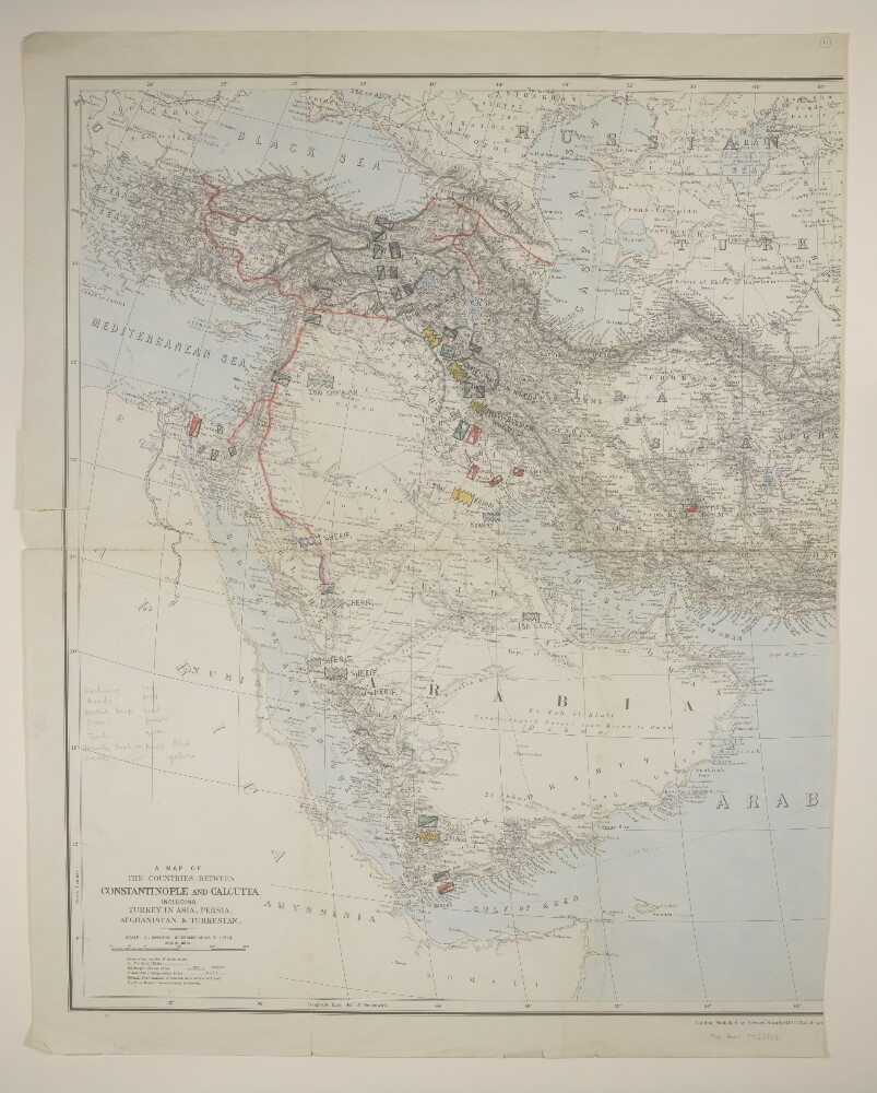
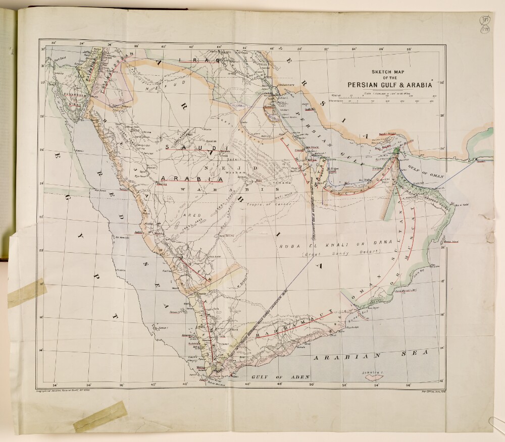
Abstract: Western half of printed map sheet; the eastern half, disassociated, was not present on transfer.Western portion bears the imprints 'London; Published by Edward Stanford, Ltd., 12, 13, & 14, Long Acre, W.C., Oct. 1st., 1912' and '11012'. Covers western Asia, including the Arabian Peninsula. Portrays hydrology, relief by spot heights and hachures, roads, railways, submarine telegraphs, settlements, place names and international boundaries. A full copy of this map, also incorporating a red plate not present on this version (showing steamship routes, proposed railways and limits of British jurisdiction in Persia [Iran]), is filed at Maps X.6918.Manuscript additions portray supplementary railway information, religious sites, naval and submarine bases and oil sites, and includes strategic notes.Creation end date derived from position of military forces on Mss Eur F112/552, f 11.Verso bears the note 'Arabia [?]Sykes'.Physical description: Materials: Printed, with manuscript additions in ink, pencil, crayon and watercolour, on paperDimensions: 630 x 577mm, on sheet 710 x 616mm
Abstract: Western half of printed map sheet; the eastern half, disassociated, was not present on transfer.Western portion bears the imprints 'London; Published by Edward Stanford, Ltd., 12, 13, & 14, Lon[g Acre, W.C., Oct. 1st., 1912]' and '11012'. Covers western Asia, including the Arabian Peninsula. Portrays hydrology, relief by spot heights and hachures, roads, railways, submarine telegraphs, settlements, place names and international boundaries. A full copy of this map, also incorporating a red plate not present on this version (showing steamship routes, proposed railways and limits of British jurisdiction in Persia [Iran]), is filed at Maps X.6918.Manuscript additions portray supplementary road and railway information, and the positions of British, Russian, Turkish, and 'friendly' or 'hostile Arab or Kurd' forces.Creation start date derived from imprint (11012) and Mss Eur F112/552, f 12; end date derived from position of military forces.Verso bears the note 'Arabia [?]Sykes'.Physical description: Materials: Printed, with manuscript additions in ink, pencil, crayon and watercolourDimensions: 630 x 521mm, on sheet 710 x 561mm
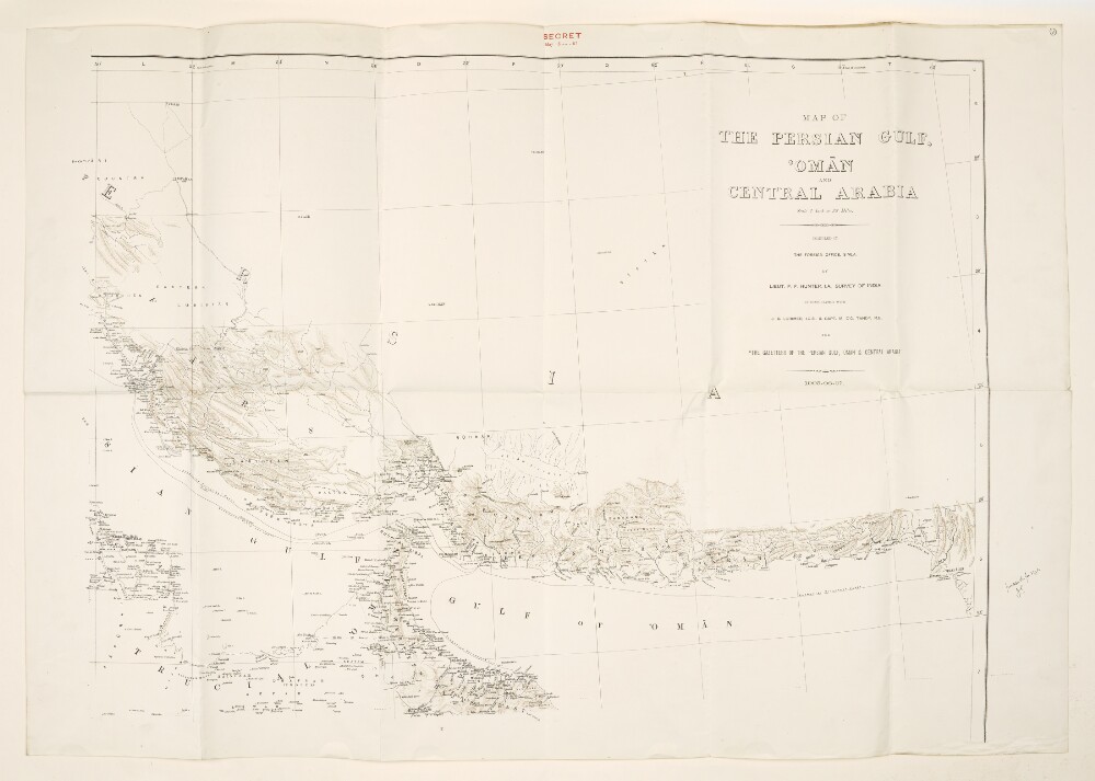
Abstract: Imprint:Heliozincographed at the Office of the Trigonomertical Branch, Survey of India, Dehra Dún. Outline and hill shading by Munshi Karim Bakhsh. Typing by Munshis [sic] Karim Bakhsh and Tufail Ahmad Khán.Distinctive Features:Relief shown by hachures and spot heights.Map of the Persian Gulf and Arabian Peninsula compiled to accompany the 'Gazetteer of the Persian Gulf’ by John Gordon Lorimer, showing the routes, railway schemes both completed and under construction, submarine telegraph lines and province and district boundaries in the region.Map is divided into squares with borders lettered and numbered for reference. Includes ‘Index to Names Occurring in Gazetteer of Persian Gulf’ arranged alphabetically with place names listed in both English and Arabic. Also contains a key to symbols and abbreviations and an explanation of type used on the map.Classified ‘Secret’ with instructions for the ‘Custody and Disposal of Secret Documents Issued by the Chief of the Staff’ signed by B. Duff, Lieutenant-General, Chief of Staff.Inscriptions:On recto in the upper right-hand corner above neat line in red ink: ‘Copy No. 35’.Physical description: Dimensions:1225 x 1750 mm, on sheet 1312 x 1816 mm
Abstract: Map of the Persian Gulf and the Gulf of Oman, showing the northernmost part of the Arabian Peninsula on one side, and parts of southern Persia [Iran] on the other. The map indicates roads, railways, telegraph lines and hydrology, and provides some indication of relief. Produced by the Survey of India, with a printing statement noting that the map was compiled in consultation with John Gordon Lorimer and Captain Maurice Patrick O'Connor Tandy, for
The Gazetteer of the Persian Gulf, Oman and Central Arabia.The scale is given as 1 inch to 32 miles.Physical description: Materials: Printed in ink on paperDimensions: 663 x 874mm, on sheet 717 x 1022mm
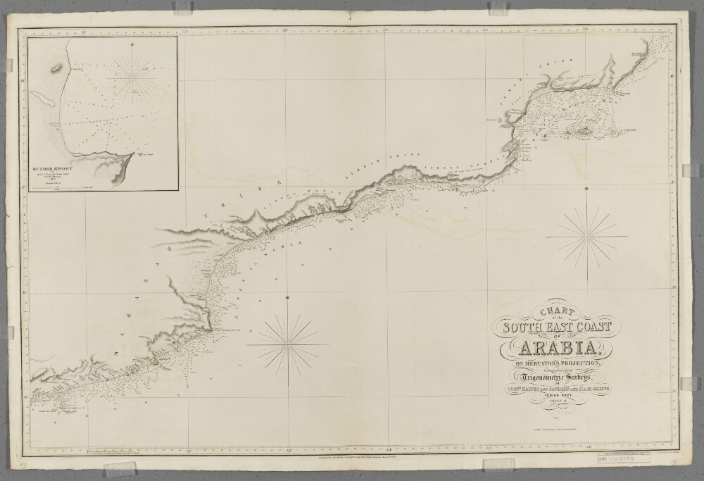
Abstract: Covers a 480-mile length of the Arabian Sea coast of the Arabian Peninsula from Misenaat [Musayni'ah, Yemen] north-eastwards to Ras Saugra [Ra's Sawqirah, Oman], together with a hinterland of approximately twenty miles. Portrays hydrology, including depths by soundings, relief by spot heights, hachures and rock drawing, sand dunes, vegetation, settlements, tribal lands and place names, and includes topographical and hydrographic notes.Includes an inset of Bundar Risoot [Bandar Raysut, Oman] at scale approximately 1:12,150, created by Messrs C Nixon and Barker Mids[hipma/en].Compiled by Commanders Stafford Bettesworth Haines and I P Sanders [most likely John Parke Sanders] and Lieutenant Albany Moore Grieve, Indian Navy. Engraved by J & C Walker. Published by John Walker, Geographer to the East India Company.Physical description: Materials: Printed on paperDimensions: 616 x 964mm, on sheet 683 x 1026mm
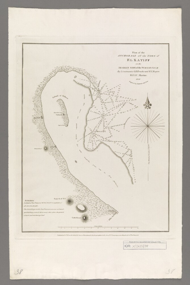
Abstract: Covers El Katiff [Al Qatif, Saudi Arabia], the surrounding Arabian Peninsula coastline and waters of the Persian Gulf to a radius of up to fifteen miles. Portrays hydrology, including depths by soundings, sands and rocks, relief by hachures, vegetation, settlements, forts and place names, and includes topographical and hydrographic notes.Surveyed by Lieutenants George Barnes Brucks and William Eales Rogers, 1825. Engraved by Bateman and Son. Published by James Horsburgh, Hydrographer to the Honourable East India Company.Physical description: Materials: Printed on paperDimensions: 346 x 270mm, on sheet 501 x 321mm
Abstract: The volume is an overview of the political history of Persia, Iraq and Arabia, authored by the Office of the Chief Political Officer, Indian Expeditionary Force “D”, and printed by the Superintendent Government Printing, Calcutta [Kolkata], India in 1917. The volume is divided into a number of chapters:1. An introduction to the political history of Persia, Iraq and Arabia, chiefly concerning Britain’s history of naval intervention and military occupation in the Persian Gulf, and its efforts in eradicating the slave trade, arms traffic and piracy;2. A chapter entitled ‘The Arab attitude in Iraq before the War’, including: political conditions in Turkish Iraq prior to the War; the arrival of the Indian Expeditionary Force “D” at the start of the War; Ottoman ‘jihad’ against the British; Arab attitudes to the British in Iraq, central Arabia and Persian Arabistan;3. British relations with Arabistan, including an overview of the Anglo-Persian War (1856-57), and a brief outline of the Anglo-Persian Oil Company’s activities in the region;4. The Bakhtiari tribes, their leaders and their standing with the Persian Government, and the importance of maintaining British relations with them, with reference to trade routes, the maintenance of order in the oil fields, and the maintenance of friendly relations with the Shaikh of Muhammareh [Khorramshahr] and the Russians at Ispahan [Isfahān, or Eṣfahān];5. Pusht-i-Kuh – ‘the right flank of Indian Expeditionary Force “D”’: a description of the area, and its strategic and economic importance, including: topography; climate; the position and powers of its Wali [governor] (taken from Lorimer’s
Gazetteer of the Persian Gulf), the Wali’s relatives; and Kaka Siyah, who reside in the region and who are of African origin;6. Arabia – the left flank of Indian Expeditionary Force “D”. The chapter is divided into two parts. The first part is a general description of the Arabian peninsula, including: topography and geographic features; political powers in Arabia: the Wahhabi, with a history of their development and territorial gains; Egypt; Ibn Rashid [Ibn Rashīd]; the British Government; and Turkish interests in Arabia. The second part is a detailed historical outline of British relations with Ibn Sa‘ūd;7. Entitled
The Trend of Turkish policy before the War and since (official), and subdivided into parts on internal and external politics. The first part includes an assessment of the characteristics of ‘Ottoman people’ and their Government, the second concentrates on German influence and activity in Ottoman territories.There are pencil annotations on the front flyleaf of the volume (folio 2), which make note of sections within the volume, with the corresponding page numbers.Physical description: Foliation: There is a foliation sequence, which is circled in pencil, in the top-right corner of the recto of each folio. It begins on the front cover, on number 1, and ends on the inside of the back cover, on number 29.Pagination: A printed pagination system runs through the volume (ff 7-27), the numbers of which are located top and centre of each recto and verso.
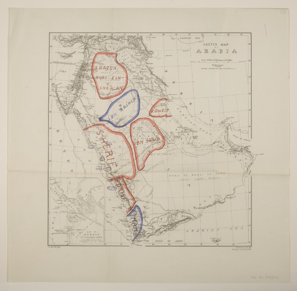
Abstract: Printed sheet bearing the series designation 'I[intelligence].D[ivision].W[ar].O[ffice]. No. 1835' and the imprint 'Corrections, July, 1905. Railways revised Sept. 1906.' Portrays hydrology, relief by hachures, railways, roads, submarine telegraphs, settlements, place names and international boundaries; includes an inset (120 x 98mm) titled 'Map of Koweit and Surrounding Country' at scale 1:2,027,520. Manuscript additions portray 'Friendly Confederations' in red and 'Hostile Confederations' in blue (see also Mss Eur F112/552, ff 3-4, from which this terminology is taken).Creation end date derived from date of Arab Revolt.A colour version of this sheet, without manuscript additions, is filed at Maps MOD GSGS 1835.Physical description: Materials: Printed, with manuscript additions in coloured ink and watercolourDimensions: 385 x 384mm, on sheet 498 x 507mm
Abstract: Sketch map depicting the Arabian Peninsula, with the Red Sea and the Persian Gulf on either side. The map indicates boundaries, settlements, and hydrology, and provides some indication of relief.The map, which is attributed to the War Office, is dated June 1914 but has a number of annotations in ink, presumably dating from 1932-1934, which reflect the creation of new states (e.g. Saudi Arabia). Significant place names are underlined in red, and each country or region has been colour-coded according to its status.Physical description: Dimensions: 466 x 557mm, on sheet 569 x 643mm.Materials: Printed on paper.