Abstract: Distinctive Features:Copy based on a map of Asia drawn to scale 1:1,000,000 issued by the War Office with adjustments controlled by traverses made during a survey carried out in February 1933 for the Iraq Petroleum Co. Ltd.Shows roads and wells with boundary indicated by dash-dot line.Inscriptions:On verso, in the lower right in pencil: ‘See 82/27 – V paper 51’.Physical description: Dimensions:389 x 235 mm, on sheet 417 x 329 mm
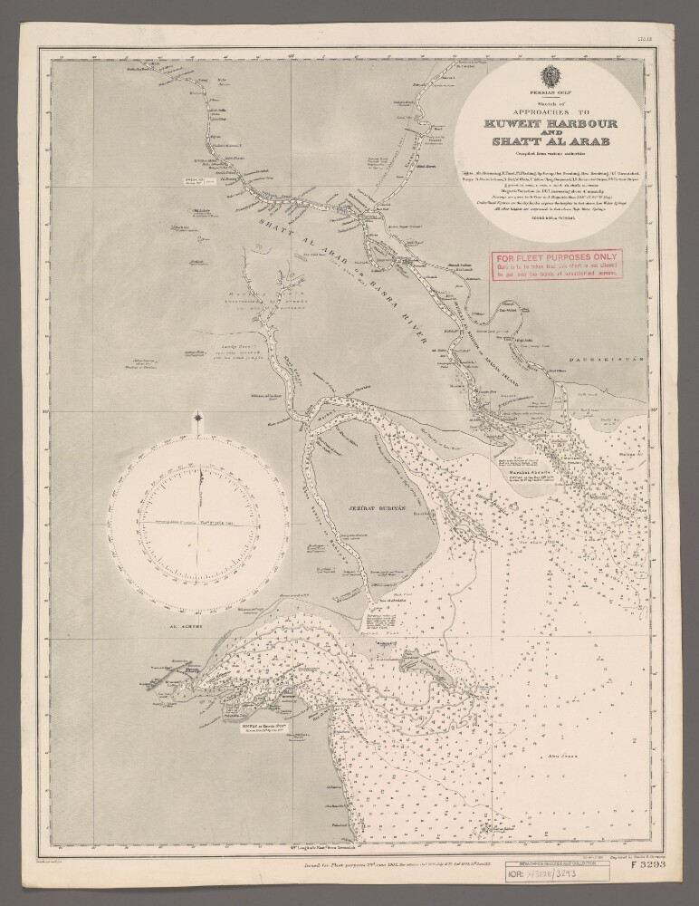
Abstract: Chart F3293.Hydrographic chart of the Shatt al Arab in southern Mesopotamia from the vicinity of Al Basra [Al Basrah, Iraq] approximately 100 miles south-eastwards to its mouth at the head of the Persian Gulf. Also includes the approaches to Kuweit [Kuwait] Harbour. Portrays hydrology, including depths by soundings and contours, sands, rocks and mud, relief by spot heights and shading, vegetation, cultivation, canals, settlements including significant buildings, forts and tombs, and place names, and includes topographical notes and navigational aids, including buoys, lights and prominent buildings.Compiled 'from various authorities'. Engraved by Davies & Company. Published by the Admiralty and 'issued for Fleet purposes' 1902, with new editions 1904, 1907, 1909 and 1912, and small corrections.The sheet bears the stamps:'For Fleet Purposes Only. Care is to be taken that this chart is not allowed to get into the hands of unauthorised persons' in red on the map face.The number '170.12' in black in the upper right margin.Physical description: Materials: Printed on paperDimensions: 597 x 456mm, on sheet 660 x 507mm
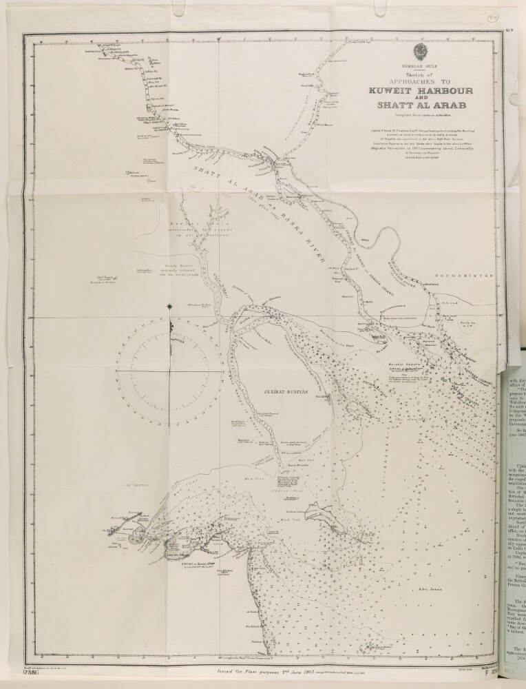
Abstract: The sketch map shows approaches to Kuwait [Kuwait] Harbour and Shatt Al Arab. An Admiralty sea map, it states it is compiled from various authorities, and is found in the volume 'Report and Proceedings of the Standing Sub-Committee of the Committee of Imperial Defence on the Persian Gulf', 1911.It indicates: heights above Water Springs, depth soundings, different types of lights and buoys, gravel, mud, rock, sand, shells, and stones; with additional comments on wrecks, tides, floods, and landing places.Two compass roses are included noting the predicted magnetic variation for 1915.In includes a printing statement as follows: 'Issued for Fleet purposes 2nd June 1902. New editions December 1904, July 1907, October 1909. Engraved by Davies & Company. F 3293'.Physical description: Materials: Printed on paperDimensions: 588 x 450mm, on sheet 643 x 495mm
Abstract: A map originally issued for Fleet purposes, 2 June 1902. Large corrections made December 1904, and July 1907. Small corrections made December 1906, July 1908, and September 1908.The map shows lights, gravel, mud, rock, sand, shells and stones.Physical description: Materials: printed on paper.Dimensions: 610 x 470mm, on a sheet 655 x 480mm.
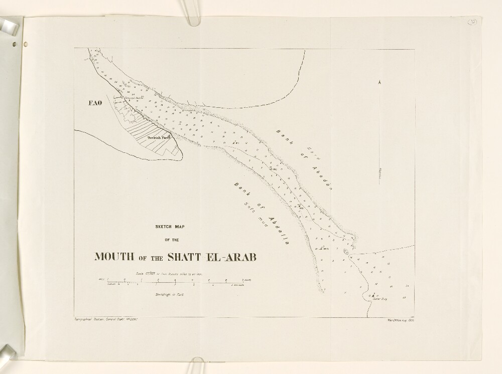
Abstract: The map depicts the mouth of the Shatt El Arab waterway with soundings in feet. It includes a diagram of the settlement of Fao, the location of the 'Turkish Fort', and the telegraph station.The scale is stated as 1/97,280 or 1.535 statute miles to the inch. An arrow indicates magnetic north.The map was prepared by the Topographical Section, General Staff of the War Office in 1905.Physical description: Materials: Printed on paperDimensions: 340 x 450mm
Abstract: The file is a report, compiled by the Army Headquarters and printed in 1914 at the Government Monotype Press (Simla), regarding planning for operations in Turkish Mesopotamia (Iraq). The report has been compiled on the basis of the latest information available and with approval of His Excellency the Commander-in-Chief.The report is divided into two sections. The first section, entitled 'Information' (folios 2-3), gives topographical and geographical information concerning Iraq, as well as details concerning supplies, telegraphic communications, naval and military strength, the local Arabs of Mesopotamia, and important local chiefs. A further paragraph (number 11 on folio 3v) has been pasted into the report after printing. The second section, entitled 'Plan' (folio 4), sets out a plan of operations for the occupation of Basrah [Basra] and the Shatt-al-Arab [Shaṭṭ al-‘Arab], as part of Britain's general scheme of military action against Turkey. Details are given regarding the strength of Turkish forces, landing at Umm Qasr, local chiefs, clothing and tentage, special equipment, transport, and supplies.The file also includes a map, 'Lower Mesopotamia', on folio 5, which is referenced in the text of the report.Physical description: Foliation: The foliation sequence commences at the front cover, and terminates at the inside back cover; these numbers are written in pencil, are circled, and are located in the top right corner of the recto side of each folio. The volume also contains an original printed pagination sequence.
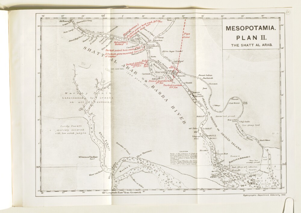
Abstract: Imprint:Hydrographic Department Admiralty, 1921.Distinctive Features:Relief shown by shading. Depths shown by soundings.Map of Shatt Al Arab with additions in red showing the movements of Turkish military forces and oil works and pipe line in Abadan area.Contains notations concerning navigation and terrain features.Physical description: Dimensions:212 x 245 mm, on sheet 298 x 355 mm
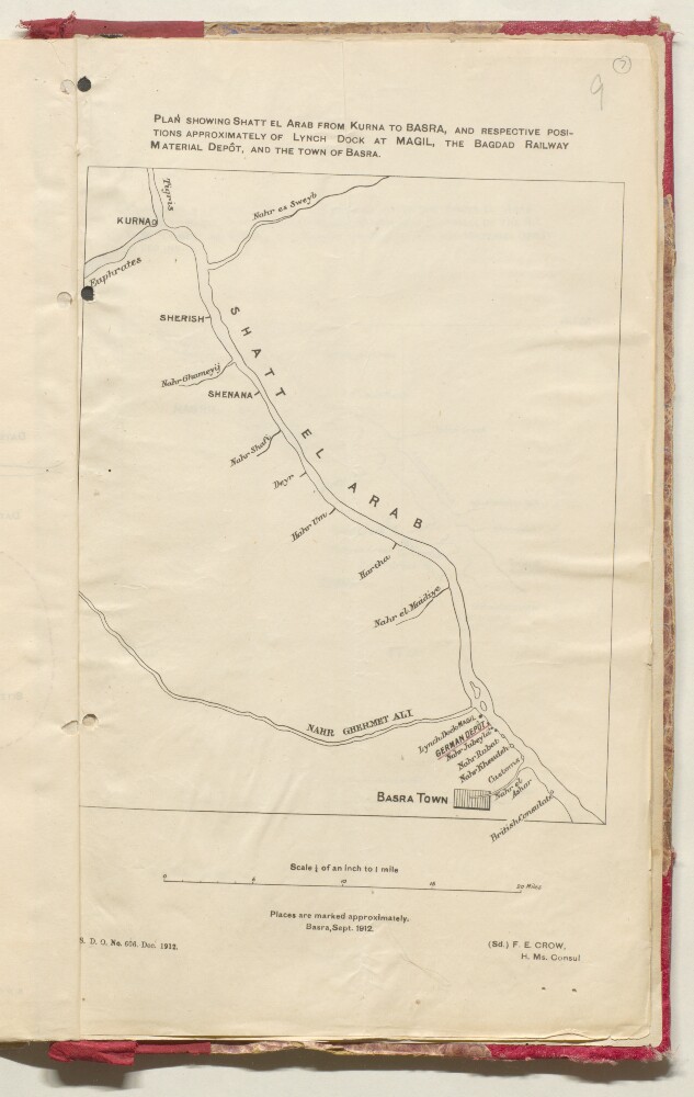
Abstract: Distinctive Features:Produced in Basra, Sept. 1912 and signed ‘Sd. F.E. Crow H. Ms. Consul’. Rough plan of area north of Basra with location of German Depot and British Consulate shown.In the bottom left-hand corner printed: ‘S.D.O. No. 606. Dec. 1912’.Physical description: Dimensions:345 x 210 mm
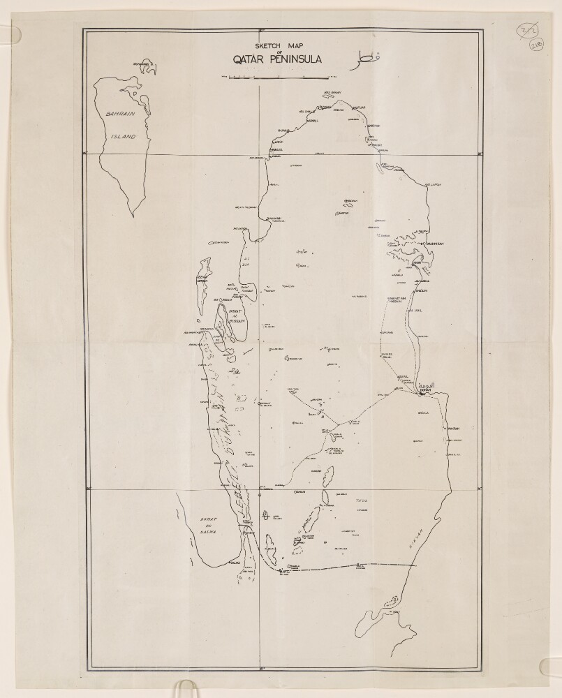
Abstract: Distinctive Features:Tracing of a map of the Qatar Peninsula dated 8th September 1937, sent in reference to the Residency Express letter No. 839-S.Shows the proposed Saudi-Qatar border with motor routes indicated by red pecked lines and location of wells marked. Contains a key to symbols in the lower left-hand corner.Physical description: Materials:Pen and ink on tracing clothDimensions:838 x 519 mm, on sheet 1027 x 763 mm
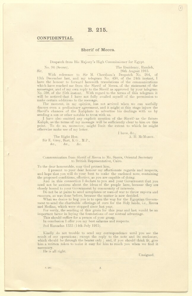
Abstract: The file consists of a confidential printed report entitled 'Sherif of Mecca'. The report contains transcriptions of correspondence, a statement by a messenger (described below), and notes relating to Sherif Hosayn, the Sherif [Shereef] of Mecca [Ḥusayn bin ‘Alī], particularly in terms of his relations with the United Kingdom and the Ottoman Empire. The report contains the following sections:Dispatch from His Majesty's High Commissioner for Egypt (Sir Arthur Henry McMahon), dated 26 August 1915;Communication from the Sherif of Mecca to Mr Storrs [Ronald Henry Amherst Storrs], Oriental Secretary to British Representative Cairo, dated 14 July 1915;Statemement of Messenger, Mohammed Ibn Arif Ibn Oreifan, 18 August 1915;Family and Agents of the Sherif, by 'R S' [Ronald Henry Amherst Storrs], dated 19 August 1915;Note on communication from the Sherif of Mecca, by 'R S' [Ronald Henry Amherst Storrs], dated 19 August 1915;Letter from Sir Arthur Henry McMahon to His Highness the Sherif Hosayn (undated).The file contains five copies of the report, only one of which has been foliated and digitised.Physical description: Foliation: the foliation commences at 1 on the first folio and terminates at 4 on the last folio. The numbers are written in pencil, are enclosed in a circle, and appear in the top right corner of the recto page of each folio.Pagination: the document also has an original printed pagination, numbered 2-7 (folios 1-4).
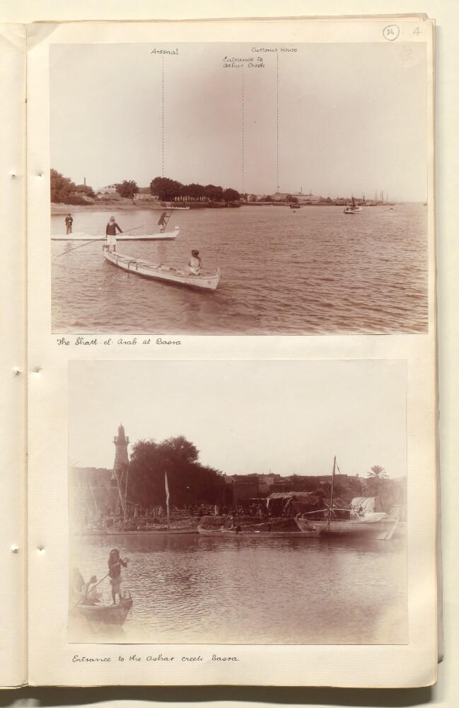
Abstract: Genre/Subject Matter:View of the Shatt-el-Arab at Basra. In the foreground and middle-ground at let two canoe-like boats hold two men each. In the background the arsenal, the entrance to Ashar Creek and the customs house are marked in ink on the photograph.Inscriptions:Ink, below image: 'The Shatt-el-Arab at Basra'Pencil, above image to the right: ‘26’Ink, inscribed on image: ‘Arsenal’; ‘entrance to Ashar Creek’; ‘Customs House’Physical description: Dimensions:150 x 193 mmCondition:The print is in good condition throughout.Foliation:‘26’
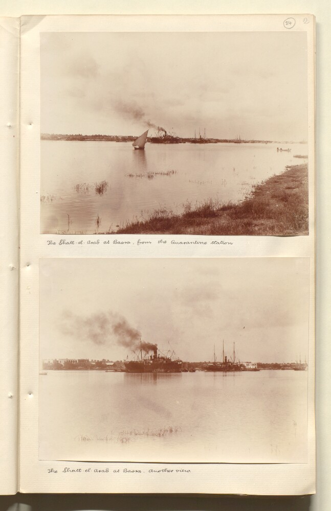
Abstract: Genre/Subject Matter:View of the Shatt-el-Arab at Basra. At least one large steamship is visible at centre in the background while other large sailing ships are moored at right and smaller craft alongside the steamer. This view is a closer view of the same scene in IOR/L/PS/20/C260, f 24 1.Inscriptions:Ink, below image: ‘The Shatt-el-Arab at Basra. Another view’Physical description: Dimensions:146 x 190 mmCondition:The print is in good condition throughout.Foliation:‘24’