Number of results to display per page
Search Results
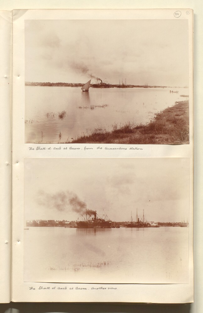
25. 'The Shatt-el-Arab at Basra, from the Quarantine station' by Wilfrid Malleson
- Description:
- Abstract: Genre/Subject Matter:View of the Shatt-el-Arab at Basra. At least one large steamship is visible at centre in the background while other sailing ships and one mehaleh is visible.Inscriptions:Ink, below image: ‘The Shatt-el-Arab at Basra, from the Quarantine station’Physical description: Dimensions:143 x 191 mmCondition:The print is in good condition throughout.Foliation:‘24’
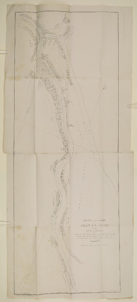
26. 'Sketch of the Course of the Shat Ul 'Arab from the Entrance to Mahomerah'
- Description:
- Abstract: Imprint:Lithographed in the Office of the Chief Engineer of P.W. by H Essoobyee, and F de Jesus, Bombay, 7 March 1857.Distinctive Features:Below title the note: 'by Captain Felix Jones, Resident Persian Gulf, and Captain M. Green, Sind Horse, constructed while reconnoitring the Enemy's position at Mahomerah [Khorramshahr] in Company with Commander Ethersey and Captain J.W. Young. J.N. in February 1857’.Shows the course of the Hugh Lindsay by blue line.The place names are given in English and Persian.Physical description: Dimensions:1130 x 425 mm; on sheet 1180 x 524 mm or smaller.Foliation: The map sheet has been foliated in the top right hand corner of the folio with a pencil number enclosed in a circle.
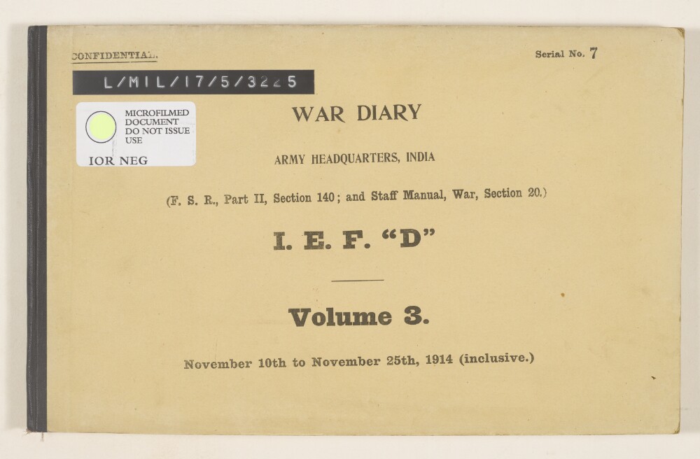
27. ‘WAR DIARY. ARMY HEADQUARTERS, INDIA. […] I.E.F. “D”. Volume 3. November 10th to November 25th, 1914 (inclusive.)’
- Description:
- Abstract: The volume contains a chronological list of brief summaries of papers relating to the activities of the Indian Expeditionary Force D (also known as the Mesopotamia Expeditionary Force) between 10 and 25 November 1914. This is accompanied by appendices containing copies and extracts of these papers, which include: letters, orders, and telegrams containing instructions and reports.A summary of the contents of this volume is pasted on the leading flyleaf, under the subtitle ‘Advance to Basrah [Basra]’:‘Action at Saniyeh’‘General Barrett arrived at Saniyeh’‘Action at Sahil’‘Action at Saihan [Qaryat Sayhan]’‘130th stopped and 22nd diverted to Basrah’‘17th Brigade sailed’‘Force “D” arrived at Basrah’.The volume contains numbers and details of soldiers who were wounded or killed.A summary of contents for the previous volumes is pasted on the inside front cover.Physical description: Foliation: the foliation sequence (used for referencing) commences at the first folio with 1 and terminates at the last folio with 57; these numbers are printed, and are located in the bottom centre of the recto side of each folio. The foliation sequence does not include the front and back covers, nor does it include the leading and ending flyleaves.The sequence contains one foliation anomaly, f 24a.Dimensions: 21x33cm
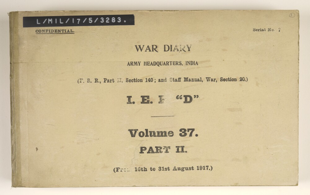
28. ‘WAR DIARY. ARMY HEADQUARTERS, INDIA. […] I.E.F. “D”. Volume 37. PART II. (From 16th to 31st August 1917).’
- Description:
- Abstract: The volume contains a chronological list of brief summaries of papers relating to the activities of the Indian Expeditionary Force D (also known as the Mesopotamia Expeditionary Force) between 16 and 31 August 1917. This is accompanied by appendices containing copies and extracts of these papers, which include: letters, telegrams, notes, reports, tables, and memoranda.An index to the contents of this volume and a summary of the contents can be found at IOR/L/MIL/17/5/3282. The volume concerns:Appreciations [reports] and intelligence summaries from the Directorate of Military Operations dated 19 August 1917 (ff 53-55), 26 August 1917 (ff 162-164)One diary of information dated 28 July 1917 (ff 84-86) covering climate, floods, and the Christians of MesopotamiaReinforcements for Force DMovements of Turkish [Ottoman], Russian, and German troops and German officials, including General Erich von FalkenhaynReports from the Royal Flying Corps of machines in service and pilots availableProvision and movements of river craftProgress of railway constructions and future railway policy, including Turkish [Ottoman] railway constructionThe composition of the committee of enquiry into port congestion at Basrah [Basra]A scheme to stimulate cultivation by clearing the canals of the Euphrates area and providing advances of seed and cashInvestigation of postal arrangementsA fodder production scheme using local labourersA discussion of whether the French Consul at Basrah, Monsieur Roux, should be permitted to use a cipher and locked bag, and proceed beyond BasrahTrade between Basrah and BaghdadThe appointment of Sir Percy Cox as Civil Commissioner, MesopotamiaA proposal to terminate the agreement between HM Government and the Newspapers Proprietors’ Association employing Edmund Candler as Official EyewitnessA new Indian General HospitalThe appointment of R G Garrow as recognised irrigation expert for Mesopotamia.Proposed co-operation with the Russians.The following tables appear:Distribution of troops 29 July 1917 Mesopotamia Expeditionary Force (ff 8-12)Weekly return sick and wounded w/e 28 July 1917 (ff 23-24), 4 August 1917 (f 72)Ration strength of MEF 14 July 1917 (ff 26-29), 21 July 1917 (ff 102-105), 4 August (ff 136-138), 28 July 1917 (ff 181-184), 11 August (ff 199-201)State of supplies 18 August 1917 (ff 69-71 and 88-89), 25 August (ff 188-190 and 210-211)Distribution of the Turkish Army 21 August 1917 (ff 75-77), 28 August 1917 (ff 194-195)Strength return for IEF D 30 June 1917 (ff 118-135)Monthly distribution report of motor vehicles 1 July 1917 (ff 202-207).The file also contains a ‘Report on the conservancy of the Shatt-el-Arab [Shatt al-Arab] River from the Port of Basra to the Persian Gulf’ by Brigadier-General George Buchanan, Director of Port Administration and Conservancy, dated 22 March 1917, including nine maps of the Shatt-el-Arab River, the port of Basra, Mohammerah [Khorramshahr] bar, and the channel from Fao [Al-Faw] down the river.Physical description: The foliation sequence commences at the front cover with 1 and terminates at the inside back cover with 262; these numbers are written in pencil, are circled, and are located in the top right corner of the recto side of each folio. Multiple additional mixed foliation/pagination sequences are also present in parallel; these numbers are printed.Dimensions: 21 x 33cm
29. 'Note on the Turkish Fort at Fao on the Shat-el-Arab. (With Sketch Map of the Shat-el-Arab.) 1883 to 1897.'
- Description:
- Abstract: A memorandum of the events and correspondence relating to the Turkish construction of a fort at Fao on the Shat-el-Arab. The memorandum reproduces a number of representations made by the British Government both directly to the Turkish Porte and through the Persian Government, objecting to the construction of the fort on the grounds that it was said to contravene a Turco-Persian agreement of 1847. By June 1897 the fort is said to have fallen into decay and to be without guns, but the memorandum concludes that the British must resort to other means if construction of the fort is revived. The memorandum is written by Edmund Neel, Political and Secret Department, India Office, and provides a map at folio 19.Physical description: Foliation: the main foliation sequence (used for referencing) commences at folio 18 and terminates at folio 26, as it is part of a larger volume; these numbers are written in pencil, are circled, and are located in the top right corner of the recto side of each folio. Two additional foliation sequences are present in parallel; these numbers are also written in pencil, but one set is circled and crossed through, the other set is not circled.
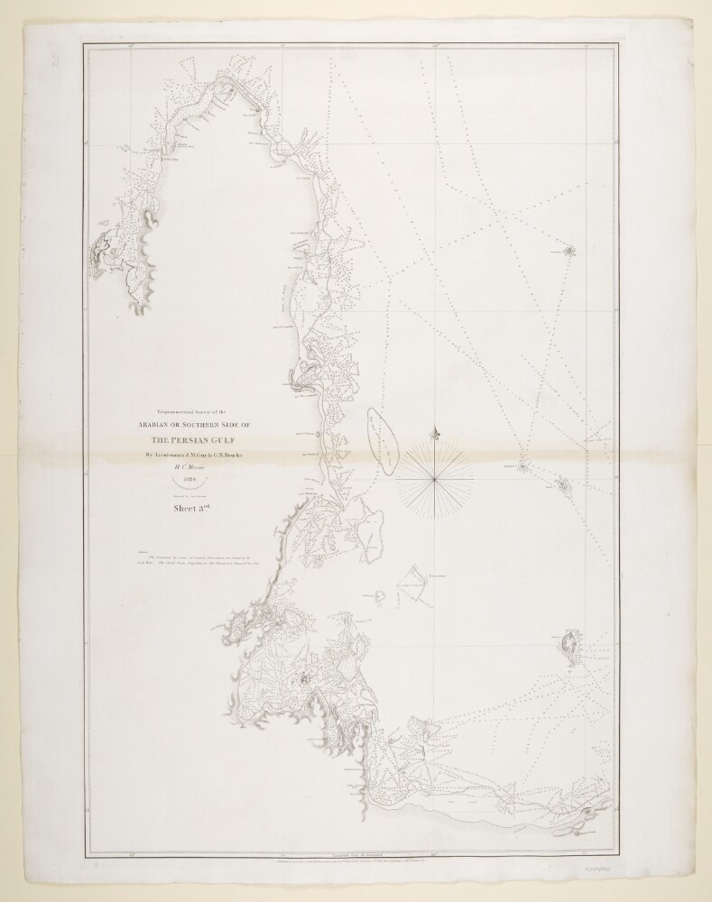
30. ‘Trigonometrical Survey of the Arabian or Southern Side of the Persian Gulf By Lieutenants J.M. Guy & G.B. Brucks H.C. Marine. 1824. Drawn by Lieutt. M. Houghton Draughtsman H.C.M. Engraved by John Bateman. Sheet 3rd’
- Description:
- Abstract: Imprint:Published by James Horsburgh, Hydrographer to the East India Company.Distinctive Features:Relief shown by hachures. Depth shown by soundings.Nautical chart of the western coast of the Persian Gulf showing the Qatar Peninsula compiled from the surveys carried out by the Bombay Marine’s officers between 1820 and 1829.Shoals and rocks represented by crosses.Includes notes on latitude and longitude variations and sources used in compilation of the map.Physical description: Dimensions:798 x 521 mm, on sheet 861 x 676 mm
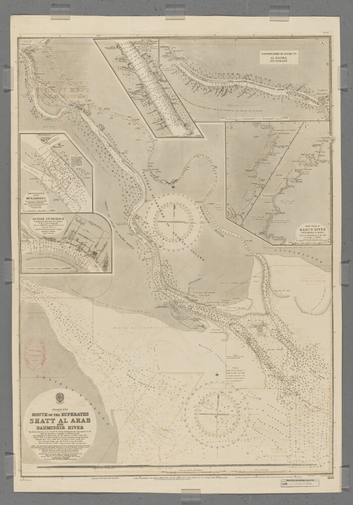
31. 'Mouth of the Euphrates, Shatt Al Arab and Bahmishir River'. September 1912 Edition
- Description:
- Abstract: Chart 1235 (September 1912 Edition)Hydrographic chart of southern Mesopotamia covering the lower Shatt al Arab (the combined mouth of the Euphrates and Tigris rivers), the Bahmishir River [Rudkhaneh-ye Bahmanshir] (a secondary estuary of the Karun River [Rudkhaneh-ye Karun]) and the head of the Persian Gulf. Portrays hydrology, including depths by soundings and contours, sands and mud, vegetation, cultivation, railways, telegraph lines, settlements including significant buildings, and place names, and includes topographical notes and navigational aids, including buoys, lights and prominent buildings. Also shows an annotated sketch view, at an unspecified scale, of the mouth of the Shatt al Arab taken from the south.Includes insets of a northwards continuation of the Shatt al Arab to Al Basra [Al Basrah, Iraq] Anchorage, at scale approximately 1:95,000; the Karun River from Ahwaz, [Ahvaz, Iran] to its confluence with the Shatt al Arab at scale approximately 1:300,000; Adaban Anchorage at scale approximately 1:22,000; Muhammera [Khorramshahr, Iran] at scale approximately 1:17,000; and Al Basra Anchorage at scale approximately 1:15,000.The river entrances surveyed by lieutenants Walford Charles Taylor, Edmund Wilmot Danson and Edward Heath Dauglish, Royal Indian Marine under the direction of Commander Charles Steward Hickman, Royal Indian Marine, and Commander Frederic Henry Walter, Royal Navy, and the officers of Her Majesty's Ship Odin, 1911. Shatt al Arab and Khor Abdalla created by Commander Willoughby George Beauchamp, Royal Indian Marine, 1899 and 1906. Bahmishir River from a sketch survey by Lieutenant Gordon S Gunn, Royal Indian Marine, 1890. Engraved by Malby & Sons. Published at the Admiralty 1898, with new editions 1899, August 1900, November 1900, 1902, 1904, 1907, 1911, January 1912, September 1912 and small corrections.The sheet bears the stamps:'Not to be used for navigation. For reference purposes only' in red on the map face.The number '279.12' in black in the upper right margin.Physical description: Materials: Printed on paperDimensions: 914 x 676mm, on sheet 996 x 689mm
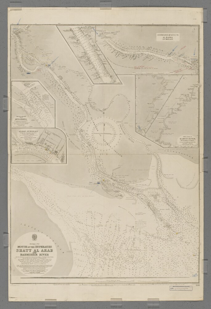
32. 'Mouth of the Euphrates, Shatt Al Arab and Bahmishir River'. June 1914 Edition with manuscript additions
- Description:
- Abstract: Chart 1235 (June 1914 Edition with manuscript additions)Hydrographic chart of southern Mesopotamia covering the lower Shatt al Arab (the combined mouth of the Euphrates and Tigris rivers), the Bahmishir River [Rudkhaneh-ye Bahmanshir] (a secondary estuary of the Karun River [Rudkhaneh-ye Karun]) and the head of the Persian Gulf. Portrays hydrology, including depths by soundings and contours, sands and mud, vegetation, cultivation, railways, telegraph lines, settlements including significant buildings, and place names, and includes topographical notes and navigational aids, including buoys, lights and prominent buildings. Also shows an annotated sketch view, at an unspecified scale, of the mouth of the Shatt al Arab taken from the south.Includes insets of a northwards continuation of the Shatt al Arab to Al Basra [Al Basrah, Iraq] Anchorage, at scale approximately 1:95,000; the Karun River from Ahwaz, [Ahvaz, Iran] to its confluence with the Shatt al Arab at scale approximately 1:300,000; Adaban Anchorage at scale approximately 1:22,000; Muhammera [Khorramshahr, Iran] at scale approximately 1:17,000; and Al Basra Anchorage at scale approximately 1:15,000.Manuscript additions in coloured ink and crayon show military movements to November 1914.The river entrances surveyed by lieutenants Walford Charles Taylor, Edmund Wilmot Danson and Edward Heath Dauglish, Royal Indian Marine, under the direction of Commander Charles Steward Hickman, Royal Indian Marine, and Commander Frederic Henry Walter, Royal Navy, and the officers of Her Majesty's Ship Odin, 1911. Shatt al Arab and Khor Abdalla created by Commander Willoughby George Beauchamp, Royal Indian Marine, 1899 and 1906. Bahmishir River from a sketch survey by Lieutenant Gordon S Gunn, Royal Indian Marine, 1890. Engraved by Malby & Sons. Published at the Admiralty 1898, with new editions 1899, August 1900, November 1900, 1902, 1904, 1907, 1911, January 1912, September 1912, May 1914, and small corrections June 1914.The sheet bears the stamp '304.14' in the upper right margin.Physical description: Materials: Printed, with manuscript additions in watercolour, coloured ink and crayon, on paperDimensions: 914 x 676mm, on sheet 1032 x 688mm
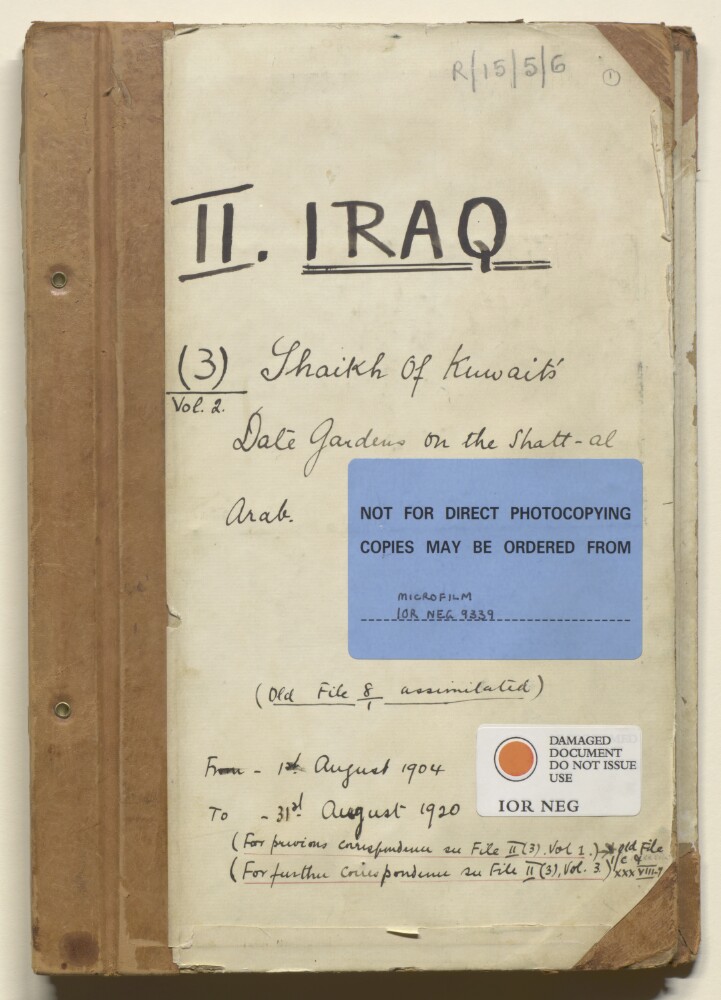
33. 'File II. IRAQ (3) Vol. 2 Shaikh of Kuwait's Date Gardens on the Shatt-al Arab'
- Description:
- Abstract: The volume comprises telegrams, despatches, correspondence, memoranda, and notes, relating to three main topics.The first main topic discussed is the Shaikh of Kuwait's date gardens on the Shatt al-Arab (ff 3-162). The discussion in the volume relates to the Shaikh's concern about the repair of embankments and the actions of Turkish soldiers in dismantling the embankments in proximity to their fort. Included in the volume is a hand-drawn plan (folio 135) of the fort, garden, embankments and marshlands in relation to the Shatt al Arab waterway.The second main topic discussed is registration of Shaikh Mubarak's property at Faddaghiya (ff 163-311). The volume includes the Arabic version with English translation (ff 165-182) of the preliminary agreement between Shaikh Mubarak al-Sabah and Abdul Wahab bin Qirtass concerning 'the property known as Fadhagiya' as well as the final deed relating to the purchase. Also included is an Arabic copy (folio 251) of 'receipts passed for land revenue paid by Shaikh Mubarak on his Faddaghiya estate'.The third main topic discussed is the dismissal of the Mudir of Fao for overstepping his authority.The principal correspondents in the volume include the Political Agent, Kuwait (Stuart George Knox; William Henry Irvine Shakespear); the Political Resident in Persian Gulf (Percy Zachariah Cox); the Secretary to the Government of India in the Foreign Department (Sir Louis Dane); the First Assistant Resident, Bushire; HBM's Consul at Basrah; and the Ruler of Kuwait (Shaikh Mubarak bin Sabah al-Sabah).Physical description: Foliation: the foliation sequence (used for referencing) commences at the front cover with 1, and terminates at the inside back cover with 340; these numbers are written in pencil, are circled, and are located in the top right corner of the recto side of each folio.A previous foliation sequence, which is also circled, has been superseded and therefore crossed out.Pagination: the file also contains a hand written pagination sequence (ff 3-339).
34. 'File VIII/3. Pedigree, Private affairs, notes, etc on the As-Subah family.'
- Description:
- Abstract: The file contains correspondence in the form of letters, notes, pedigrees, news extracts and telegrams. The correspondence is mainly related to the ruling family in Kuwait. Reports were sent between the Political Agency, Kuwait and the Political Residency, Bushire regarding the following: political and social news in Kuwait; events concerning the al-Subah family (death, marriage or illness); news of Shaikh Mubarak’s coalition with Shaikh Khaz‘al against a number of tribes in the region; and reports on incidents taking place at Mohammerah, as well as news of the status of a number of Islands, such as Warba, which were claimed by the Shaikh of Kuwait.The file contains extracts from the Bahrain and Kuwait News, Residency reports about Shaikh Mubarak’s dispute with his pearl towashes (pearlers or pearl merchants), and an article (folios 219-224) on Shaikh Ahmad’s visit to London in 1919. It also contains a number of pedigrees of the al-Subah family.The file also includes correspondence related to the number of gun salutes due to chiefs in the Persian Gulf.The main correspondence is between the Political Agency, Kuwait, the Political Residency in the Persian Gulf, Bushire, the Secretary to the Government of India, Foreign Department, and the British Consul at Mohammerah.Due to the random arrangement of the papers in the file, the earliest paper (dated Nov 1904) is found at f 144, and the latest (dated Oct 1922) is found at f 135.Physical description: Foliation: the main foliation sequence (used for referencing) commences at the front cover with 1 and terminates at the inside back cover with 230; these numbers are written in pencil, are circled, and are located at the top right corner of the recto side of each folio. An additional foliation sequence is present in parallel between ff 4-227; these numbers are also written in pencil but are not circled.
35. File 1356/1912 Pt 1 'Turco-Persian Frontier:- negotiations at Constantinople.'
- Description:
- Abstract: The volume discusses the disputed Turco-Persian Frontier, particularly at Mohammerah, and the negotiations in Constantinople to attempt to settle it.The correspondence focuses on:the differences of opinion over the actual boundary at Mohammerah, including several maps demonstrating these differences;movements of Turkish and Russian troops;ownership of the Shat-el-Arab and questions of access for navigation;copies of treaties, correspondence and memoranda dating back to 1639 relating to the question of the Turco-Persian frontier.The principal correspondents in the volume are the Secretary of State for Foreign Affairs (Sir Edward Grey); the Secretary of State for India (Robert Offley Ashburton Crewe-Milnes, 1st Marquess of Crewe); the Political Resident in the Persian Gulf (Sir Percy Zachariah Cox); the British Ambassador to Constantinople (Sir Gerard Lowther); the British Ambassador to Russia (Sir George Buchanan); the Viceroy of India (Charles Hardinge, 1st Baron Hardinge of Penshurst); the British Ambassador to Tehran (Sir George Head Barclay); representatives of the Foreign Office (particularly Alwyn Parker) and the India Office; and Arthur Talbot Wilson, on special duty in relation to the Turco-Persian Frontier.This volume is part one of two. Each part includes a divider which gives the subject and part numbers, the year the subject file was opened, the subject heading, and a list of correspondence references contained in that part by year. This is placed at the back of the correspondence.Physical description: Foliation: the foliation sequence commences at the first folio with 1 and terminates at the last folio with 436; these numbers are written in pencil, are circled, and are located in the top right corner of the recto side of each folio.The foliation sequence does not include the front and back covers, nor does it include the leading and ending flyleaves.
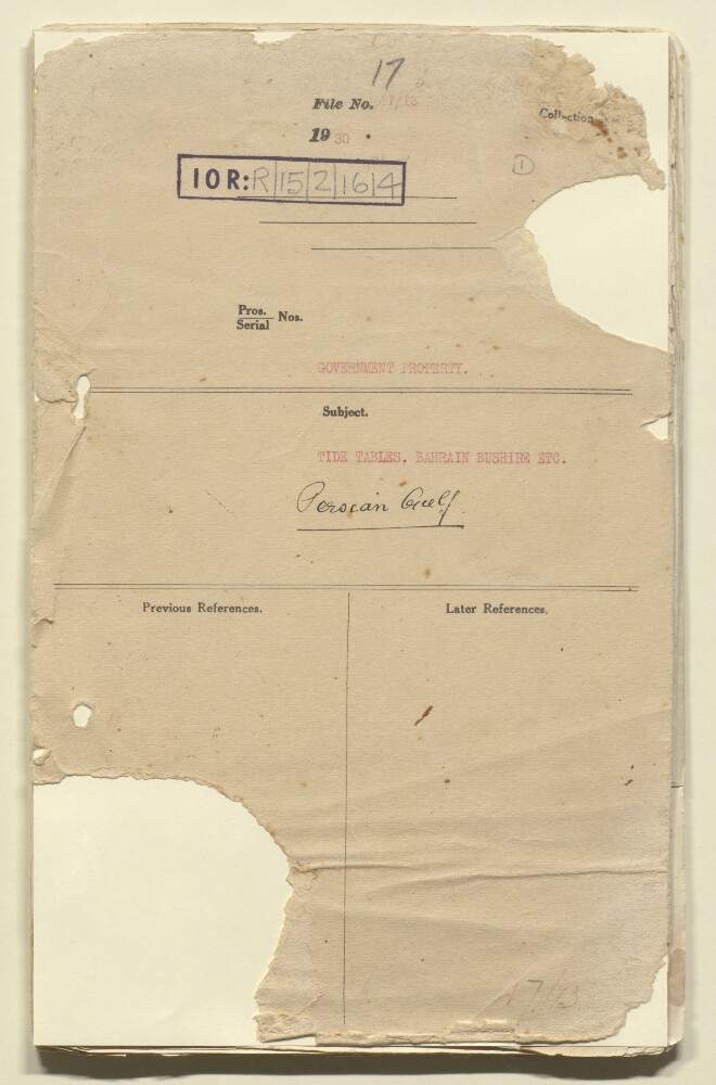
36. 'File 17/13 GOVERNMENT PROPERTY. TIDE TABLES, BAHRAIN BUSHIRE ETC.'
- Description:
- Abstract: This file concerns tide tables relating to Bahrain, Bushire and other locations in the Gulf. It consists mostly of telegrams, memoranda, and brief letters of correspondence. Most of the file documents the efforts of the Political Agent, Bahrain, to obtain copies of tide tables for the Port of Bushire, Shatt al Arab, and the Port of Basrah [Basra].Correspondents include the following: the Political Agent, Bahrain (also spelled Bahrein in some of the correspondence); the Secretary to the Political Resident in the Persian Gulf, Bushire; the Survey of India’s Map Record Office, Dehra Dun [Dehradun]; the Director of Customs and Port Officer, Bahrain; the Port Director and Director-General of Navigation, Basrah; J D Potter (publishers and Admiralty chart agents); Lawrence and Mayo Ltd (opticians and Admiralty chart agents).Physical description: Foliation: the main foliation sequence (used for referencing) commences at the front cover with 1, and terminates at the inside back cover with 60; these numbers are written in pencil, are circled, and are located in the top right corner of the recto side of each folio. An additional foliation sequence is present in parallel between ff 4-57; these numbers are also written in pencil, but are not circled.