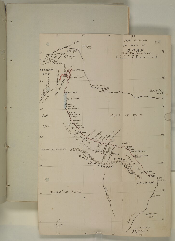
Abstract: This file is a continuation from the previous file concerning the events of the 1913 uprising of the Ibāḍī imamate and the tribes of the interior of Oman under the leadership Sālim bin Rāshid al-Kharūṣī against the authority of the Sultans of Muscat and Oman, al-Sayyid Fayṣal bin Turkī Āl Bū Sa‘īd and Taymūr bin Fayṣal Āl Bū Sa‘īd, and the subsequent intervention and deployment of British Indian troops of the 2nd Rajput Regiment stationed at Bushire. The correspondence is between Major Percy Zachariah Cox, Political Resident in the Persian Gulf at Bushire, and Major Stuart George Knox, Political Agent at Muscat, and later between Knox as officer on special duty as Resident in the Perisan Gulf, and Liutenant-Colonel Robert Aruthur Edward Benn, Political Agent at Muscat.Subjects included are: the illness of the Sultan (f 2); Muscat Arms Warehouse (ff 12-13, 18-22); the death of Sultan (f 11); succession following the death of the Sultan by his son (ff 16-17, 24, 43-44); funeral of the late Sultan (f 30) blockade of Muscat and the Batinah coast [al-Bāṭinah] (f 23); relations with the French Consul (f 45); Special Diary of the events connected with the Imam’s rising for the period 29 March to 5 April (ff 70-74); movements of the Sultan and the Imam; assistance from Shaikh Hamdan bin Zaid [Ḥamdān bin Zāyid Āl Nahyān] and other Trucial Coast chiefs (ff 120-121).There are also various extracts from Muscat News.Physical description: Foliation: The foliation sequence commences at the cover and terminates at the last folio; these numbers are written in pencil, are circled, and can be found in the top right corner of the recto side of each folio. A second foliation sequence is also present in the volume between ff. 2-122; these numbers are also written in pencil, but are not circled, and can be found in the same position as the main sequence.
Abstract: Correspondence discusses the attacks on Muscat and Mutrah by the tribes of the Omani interior. Correspondence between Robert Benn, Political Agent Muscat, the Foreign Office in London and the Political Resident in the Persian Gulf discusses:The immediate context of the situation whereby in 1913 tribal forces from the interior attacked and occupied the coastal towns of Barka and Quaryat [Qurayyāt]. These were bombarded by H.M.S.
Foxand
Dartmouth.The context of the outbreak of World War I which emboldened the rebels as they thought no ships would be available for defence of Muscat. Reports continued to be received of the determination of Shaikh Hamyar bin Nasir, the Imam's chief Lieutenant, to harrass Matrah of the Bani Battash to attack Muscat.Discussions of troop deployment and development of armed forces by Sultan Taimur bin Faisal [Taymūr bin Fayṣal].Discussion of 'pro-German propaganda'.Timing of Imam's decision to attack on 11th January 1915.Report on the events leading up to the attack with enclosures on casualties and a letter from Shaikh Isa bin Saleh al Harithi to the Sultan of Muscat; sketch map of the attack drawn by Robert Arthur Benn, Political Agent, Muscat, to illustrate the report.Correspondents include Robert Arthur Benn, Political Agent, Muscat; Stuart George Knox, On Special Duty for Political Resident Persian Gulf; Saiyid Hamad bin Hilal [Ḥamad bin Hilāl] ; Shaikh Isa bin Saleh al-Harithi [‘Īsá Bin-Ṣāliḥ al-Ḥārithī]; Sultan of Muscat.Physical description: Foliation: The foliation system in use is the sequence of numbers appearing in a circle in the top right hand corner of each page.
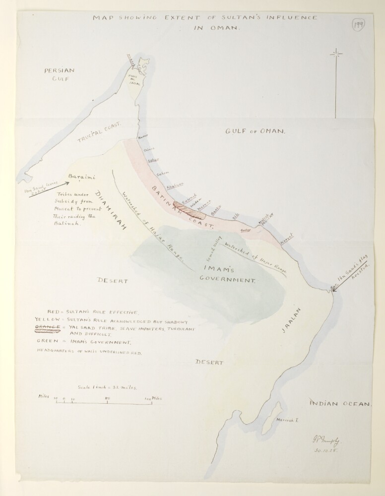
Abstract: Distinctive Features:Hand drawn sketch map by Major G.P. Murphy, Political Agent, Muscat, attached to a report on the general situation in Oman, dated 30 October 1928 (folios 195-198). Shows the extent of Sultan’s influence and nominal rule exclusive of Gwadur and Dhofar.Labelled and coloured for reference with a key provided in the lower left.Signed 'G.P. Murphy' and dated ‘30.10.28’.Physical description: Materials:Pen and ink with wash on paperDimensions:420 x 320 mm
Abstract: Distinctive Features:Coastline between Ras Mussendam (Musandam) and Ras El Hadd (Ras Al Hadd) shown in red with grid added in pencil.Tracing produced from Mr. Bower’s map which was requested by Lieutenant Colonel F.B. Prideaus, in letter dated 19th October 1925, in order to compare it with the map accompanied Alban’s confidential D.O. No. 58 of the 23rd September 1925.Physical description: Materials:Pen and ink on tracing clothDimensions:325 x 195 mm, on sheet 333 x 290 mm
Abstract: Distinctive Features:Relief shown by hachures.Provinces labelled Coastline of Oman shown in red with coast between Ras Diba and Khor Kalbah coloured blue. Grid added in pencil.Physical description: Materials:Pen and ink on paper with additions in pencil and crayonDimensions:335 x 220 mm
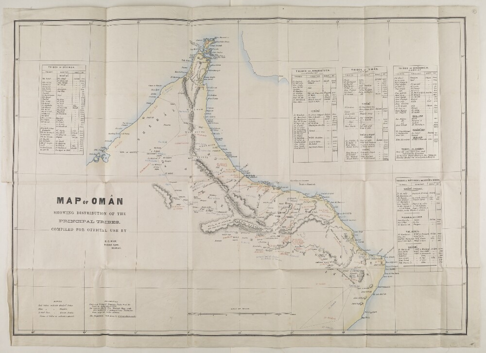
Abstract: The volume consists of the following:memorandum on tribal divisions in the Principality of Oman to accompany table of tribes, by Major Edward Charles Ross, Political Agent at Muscat (folios 2-3);table entitled 'Principal Tribes of Oman', signed by Ross (folio 4). The table is divided between the Hinawi and Ghafiri divisions and contains information in columns headed Names of Tribes. Adjective Form; Name of Tribes. Collective Plural Form; Religious Sect; Province; Villages or Districts; Number of Males; and Remarks;table entitled 'Genealogical Table of Descendants of the Imam Ahmed Al-Bu-Sa'idi', signed by Ross and dated at Muskat [Muscat] May 1872 (folio 5);map entitled 'Map of Oman Showing Distribution of the Principal Tribes. Compiled for Official Use by E C Ross, Political Agent, Muscat' (folio 6).The Arabic content of this volume is confined to letters of the Arabic alphabet appearing in the key to pronunciation and transliteration on folio 4.The date of the item is supplied by the date of Ross's tenure as Political Agent, Muscat, and by the date of the genealogical table (folio 5).Physical description: Foliation: the foliation sequence commences at 1 on the first folio after the front cover and terminates at 6, the last folio bearing text. The numbers are written in pencil, enclosed in a circle, and appear in the top right-hand corner of the recto page of each folio. The following folios need to be folded out to be examined: ff. 4, 5, 6.Condition: the front and back boards of the volume are detached.
Abstract: Distinctive Features:Relief shown by hachures and spot heights.Routes shown by dotted line with wells indicated. Names of tribes inserted on map in different colours showing their approximate location with a key provided in bottom left.The coast and principal mountain peaks are taken from the chart by Constable and Stiffe; the interior from Welstead's map and the projections from those by E B Girdlestone. Ross has corrected spellings and made additions taken from 'native sources'.Includes five tables listing names of tribes and details on their population and areas they inhabit.Physical description: Dimensions:589 x 800 mm, on sheet 659 x 930 mm
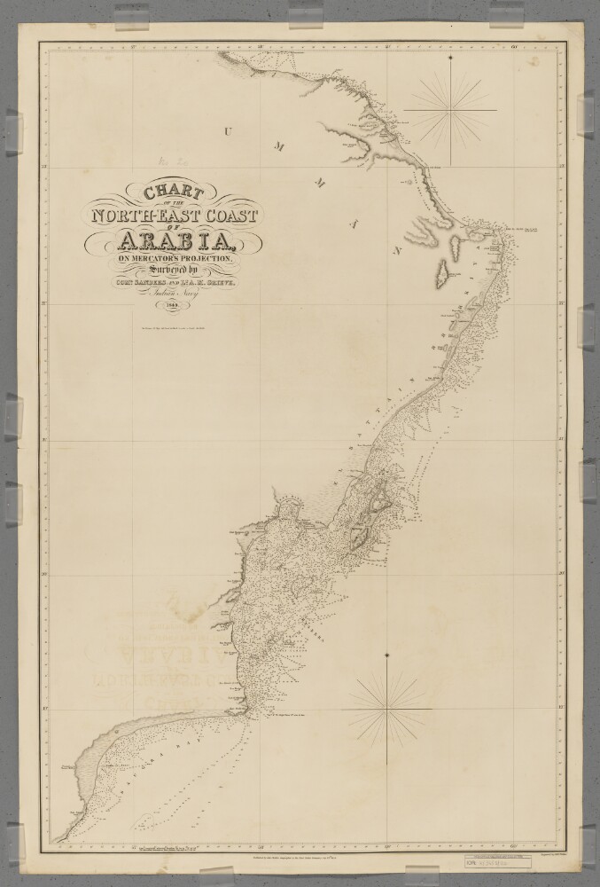
Abstract: Covers a 380-mile length of the Arabian Sea coast of Umman [Oman] from Ras Saugra [Ra's Sawqirah] north-eastwards to Ras el Hadd [Ra's al Hadd], and then a 150-mile length of the Gulf of Aden coast north-westwards to Muskat [Muscat]. Includes a hinterland of approximately twenty miles. Portrays hydrology, including depths by soundings and some contours, relief by spot heights, hachures and rock drawing, sand dunes, vegetation, settlements, tribal lands and place names, and includes topographical and hydrographic notes.Surveyed by Commander I P Sanders [most likely John Parke Sanders] and Lieutenant Albany Moore Grieve, Indian Navy. Engraved by J & C Walker. Published by John Walker, Geographer to the East India Company.Physical description: Materials: Printed on paper (backed with linen)Dimensions: 941 x 604mm, on sheet 1011 x 673mm
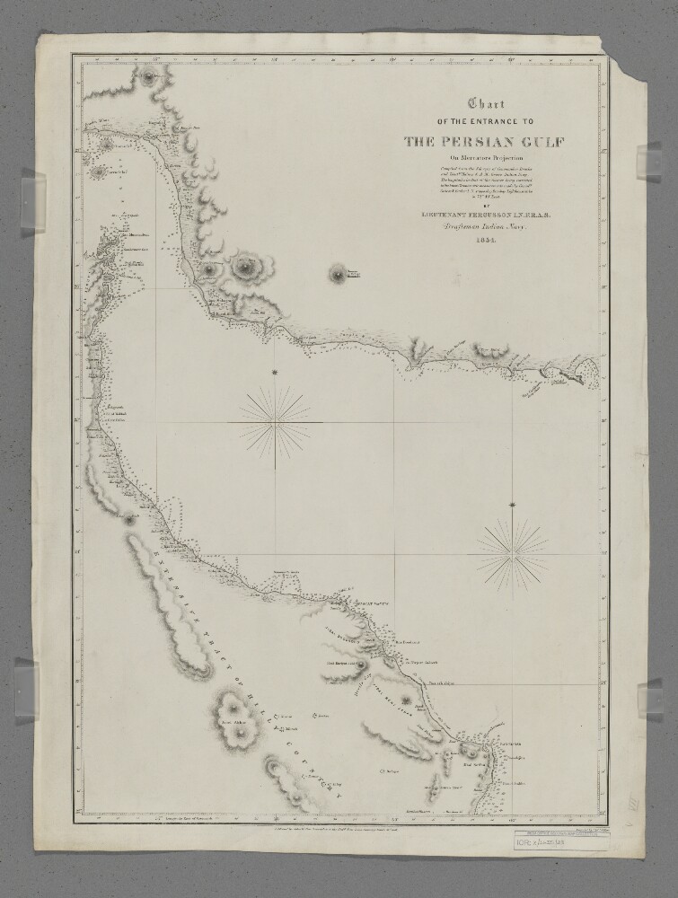
Abstract: Covers the eastern part of the Strait of Hormuz, the western part of the Gulf of Oman and the coastlines of southern Persia [Iran], northern Oman and the eastern side of the Musandam Peninsula, including a hinterland of approximately thirty miles. Portrays hydrology, including depths by soundings, sands and rocks, relief by hachures, rock drawing and occasional spot heights, vegetation, settlements, forts and place names, and includes topographical notes.Compiled by Lieutenant E F T Fergusson, Indian Navy from the surveys of Commander George Barnes Brucks and Lieutenants Stafford Bettesworth Haines and Albany Moore Grieve, Indian Navy, 1854. Engraved by J & C Walker. Published by John Walker, Geographer to the Honourable East India Company, 1857.Physical description: Materials: Printed on paperDimensions: 426 x 620mm, on sheet 678 x 508mm
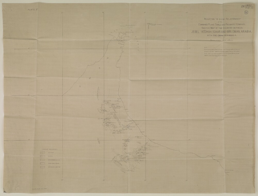
Abstract: Distinctive Features:Relief shown by hachures and spot heights.Includes a note on map compilation below title with a key of reference at the lower left.On verso, at the top right-hand corner: ‘OA 6021, 7-12-25’. Top left: ‘PLATE VI’. Bottom left: ‘M.R. REG., NO. 81, APRIL 1926’.Physical description: Materials:Print on fabricDimensions:512 x 678 mm
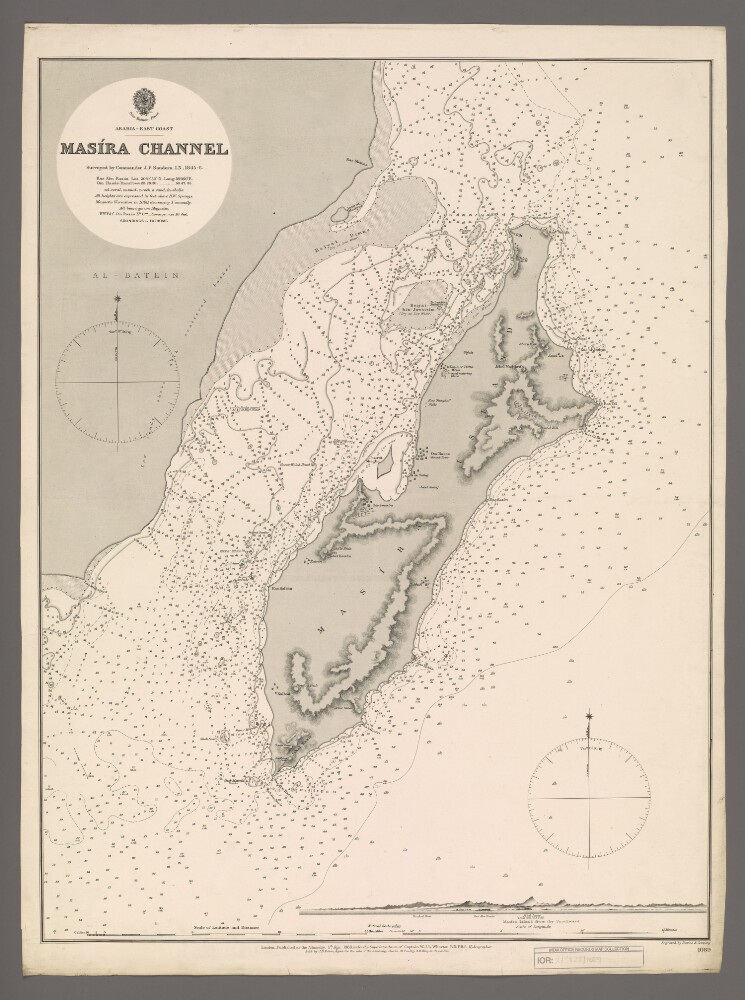
Abstract: Chart 1089.Hydrographic chart covering Masira Channel [Turʻat Masirah], the Arabian Sea, Masira Island [Jazirat Masirah] and a thirty-five-mile length of the eastern Oman coast. The Masira Channel, twelve miles wide and sixty miles long, separates Masira Island from the Omani mainland. Portrays hydrology, including depths by soundings and contours, sands, rocks, anchorages, relief by spot heights and hachures, vegetation, settlements, watering places and place names, and includes topographical notes and navigational aids, including prominent landscape features and buildings.Includes an annotated view, at an unspecified scale, of Masira Island from the south.Chart surveyed by Commander John Parke Sanders, Indian Navy 1845-1846. Engraved by Davies & Company. Published at the Admiralty, 1888.Physical description: Materials: Printed on paperDimensions: 633 x 481mm, on sheet 685 x 508mm
Abstract: This volume is Part III of Volume 1 of the
Gazetteer of the Persian Gulf, ’Omān and Central Arabia(Government of India: 1915) compiled John Gordon Lorimer. The contents are divided into two sections and contain genealogical tables of Persian Gulf and Arabian ruling families, and one map, housed in pockets.Genealogical Trees:'Table of the ruling Āl Bū Sa’īdī families of ’Omān and Zanzibar' (folio 2A, inside 'Pocket No. 1');'Table of the ruling Qasimi family of Shārjah in Trucial ’Omān' (folio 4, inside 'Pocket No. 2');'Table of the ruling Āl Bū Falāh (Bani Yās) family of Abu Dhabi in Trucial ’Omān' (folio 5, inside 'Pocket No. 3');'Table of the ruling Āl Bū Falāsah (Bani Yās) family of Dibai in Trucial ’Omān' (folio 6A, inside 'Pocket No. 4);'Table of ruling Āl ’Alī family of Umm-al-Qaiwain in Trucial ’Omān' (folio 7, inside 'Pocket No. 5');'Table of the ruling Āl Bū Kharaibān (Na’īm) family of ’Ajmān in Trucial ’Omān' (folio 8A, inside 'Pocket No. 6');'Table of Qāsimi family formerly ruling Lingeh' (folio 9, 'Pocket No. 7');'Table of the ruling Āl Tānī (Ma’ādhīd) family of Dōhah in Qatar' (folio 10A, 'Pocket No. 8');'Table of the ruling Āl Khalīfah (’Atbi) family of Bahrain (Sheet No. 1)'. (folio 11, 'Pocket No. 9');'Table of the ruling Āl Khalīfah (’Atbi) family of Bahrain (Sheets Nos. 2 and 3)' (folios 12A and 12B, 'Pocket 10');'Table of the ruling Āl Subah (’Atbi) family of Kuwait' (folio 13, 'Pocket No. 11');'Table of the ruling (Wahhābi) Āl Sa’ūd (’Anizah) family of Southern Najd (Sheets Nos. 1,2 and 3)' (folios 14, 15 and 16, 'Pocket No. 12');'Table of the ruling (Wahhābi) Āl Sa’ūd (Anizah) family of Souther Najd (Sheets Nos. 4 and 5)' (folios 17 and 18, 'Pocket No. 13');'Table of the ruling Āl Rashid (Shammar) family of Jabal Shammar' (folio 19, 'Pocket No. 14');'Table of the ruling Abul Khail (’Anizah) family of Buraidah in Qāsim' (folio 20, 'Pocket No. 15');'Table of the ruling Salaimi (Sabai) family of ’Anaizah in Qāsim' (folio 21, 'Pocket No. 16');'Table of the Qādirīyah (Saiyid) family of the Naqībis of Baghdād in Turkish Irāq' (folio 22, 'Pocket No. 17').There is also one map:'Chart Showing the Pearl Banks along the Arabian Shore of the Persian Gulf between Ras Tanurah and Diba, vide Page 2253 of Part II' (folio 27, 'Pocket No. 25').The geneaological tables were compiled by Lorimer in 1906 and 1907 and some were based on information provided by John Calcott Gaskin, Francis Beville Prideaux, and Stuart George Knox, Political Agents at Bahrain and Kuwait, as well as a number of native informants. The tables typically contain named (in Arabic and English) and unnamed individuals, chronological lists of rulers, and notes on the compilation and arrangement of the tables, and references to other parts of the
Gazetteer.The volume is labelled on the spine as 'For Official Use'.Physical description: Foliation: The foliation sequence is circled in pencil, in the top right corner of the recto of each folio. It begins on the first folio with text, on number 1, and ends on the last folio with text, on number 30.Foliation anomalies: folio 2 is followed by folio 2A; f. 6 is followed by folio 6A; folio 8 is followed by folio 8A; folio 10 is followed by folio 10A; folio 12 is followed by folio 12A and folio 12B; folio 13 is followed by folio 13A; folio 18 is followed by folio 18A; folio 20 is followed by folio 20A.