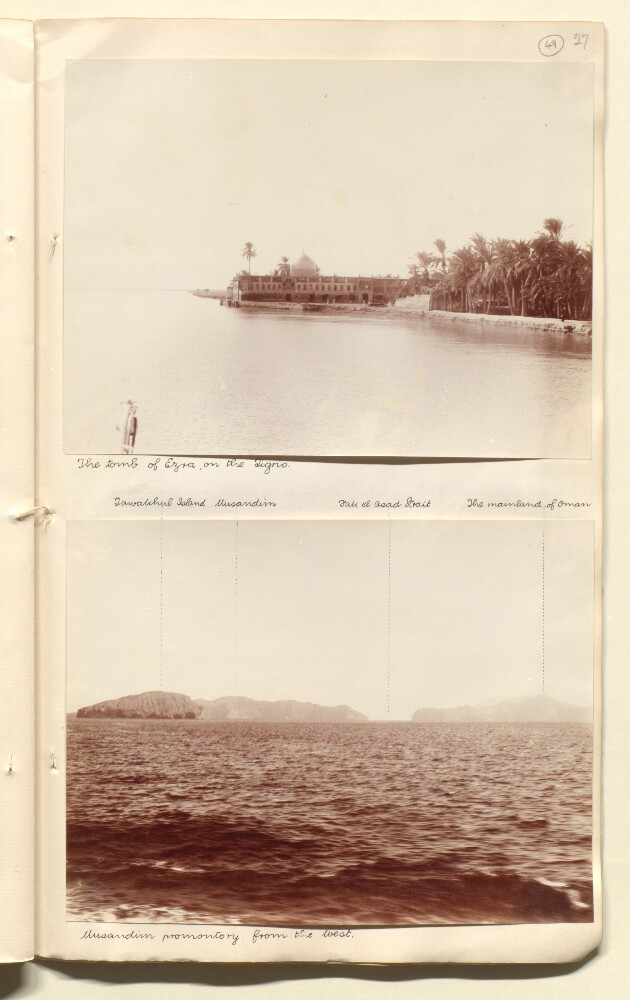
Abstract: Genre/Subject MatterView of Musandim [Musandam, Oman] Island from the south, from on board ship. Various locations are marked via stippled lines and denoted above the image in ink.InscriptionsInk, below image: 'Musandim promontory from the West.'Ink, above image, from left to right: ‘Mainland’; ‘Fak el Asad Strait’; ‘Musandim’Pencil, above image at right: ‘50’;’28’Physical description: Dimensions:141 x 188 mmCondition:The print is in good condition with minor surface dirt throughout.Foliation:‘50’
Abstract: The volume contains a ‘memoir’ written by Lieutenant Michael Houghton, draughtsman on board the Honorable Company’s ship
Discovery, which consists of a description of places encountered during the East India Company’s survey of the Persian Gulf during the 1820s. The memoir covers the survey’s journey in a southwesterly direction along the Arab coast of the Gulf, between Moosendem [Musandam] and Debay [Dubai], and taking in the principal settlements of Shaum [Ash Sha‘m or Sha’am], Ul Umrah [Jazīrah al Ḩamrā’], Raumps [Ar Rams], Rasel Khyma [Ra’s al-Khaymah], Ul Umrah [Al Jazīrah al Ḩamrā’], Amulgawein [Umm al-Qaywayn], Aymaun [‘Ajmān] and Sharja [Sharjah]. At the front of the volume is a note written by Lieutenant John Michael Guy, Lieutenant Commanding the Honorable Company’s ship
Discovery, and Officer in Charge of the Persian Gulf trigonometric survey (f 3), and a preface written by Houghton (f 4).The main body of the account provides observations of:landscape topography, including capes, mountains, inlets, bays, flora and fauna;landscape geology, including unusual rock formations, mineral deposits, ‘trap’ (igneous rock), and soil, leading at times to conjectures by the author on the historic formation of the geological landscape and its changing sea levels, with reference to the theories of contemporary scientists including Erhard Georg Friedrich Wrede and Christian Leopold von Buch;hydrography, including depths in fathoms, water currents, backwaters, and accessibility of waterways and their danger to vessels;human settlements, the names of which are transliterated into English, with descriptions of their condition (i.e. ‘deserted’), estimates of population size, tribal affiliation, details of the settlement’s chief economic activities (primarily fishing and date cultivation, with estimates of revenue), agriculture (crops and animal husbandry), descriptions of its notable built structures (forts, mosques, houses, tombs) and burial mounds;the various rulers of the region, with reference to the towns and populations they preside over, and in the case of the most prominent rulers (for example the ruler of Sharjah, Sultan ben Suggar [Shaikh Sultan bin Saqr Āl Qāsimī]) descriptions of their character, demeanour and attitude to their English visitors;climate, with details of winds, temperature and atmospheric conditions, with summaries of journal entries recorded between the months of October and May (no year stated, ff 22-24).Throughout the text Houghton makes frequent reference to ‘the expedition’, referring to the punitive expedition undertaken by the Honorable Company’s Marine to Ra’s al-Khaymah and the surrounding area (widely referred to as the ‘pirate coast’) in 1819.The volume should be read in conjunction with ‘Coast Views taken while employed on the Survey of the Arabian Side of the Gulf of Persia by Lieutenant M. Houghton, Draughtsman H.C. Marine’ (IOR/X/10310) and various maps and charts (drawn by Houghton) relating to the Arab coast of the Persian Gulf, between Musandam and Dubai (IOR/X/3680-3690).Physical description: Pagination: the volume has an original pagination system beginning at 3 and ending at 41. Numbers are located centre and top of each page of text.
Abstract: Genre/Subject MatterView of the Musandim [Musandam, Oman] Promontory from on board ship. Various locations are marked via stippled lines and denoted above the image in ink.InscriptionsInk, below image: 'Musandim promontory from the West.'Ink, above image, from left to right: ‘Tawakhul Island’; ‘Musandim’; ‘Fak el Asad Strait’; ‘The mainland of Oman’Physical description: Dimensions:146 x 191 mmCondition:The print is in good condition with minor surface dirt throughout.Foliation:‘49’
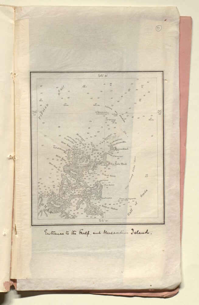
Abstract: Distinctive Features:Relief shown by hachures and spot heights. Depths shown by soundings.Nautical chart showing the entrance of the Persian Gulf and the Musandam Peninsula with details on hazardous features and tides given.Title inserted in hand below map.Physical description: Dimensions:170 x 145 mm, on sheet 340 x 200 mm
Abstract: This printed India Office report was written by John Gilbert Laithwaite and published in November 1934. It aims 'to examine, with particular reference to the proposal which has been put forward to establish a station at Khor Quwai [Khawr Quway] in the Musandim Peninsula, the history of the Declaration of 1862 by which France and Great Britain undertook to respect the independence of Muscat, and its effect, and that other existing treaty provisions, on the right of H.M. Government (subject to the consent of the Sultan of Muscat) to establish a naval station in Muscat territory.'The documents include a short note on the status of the Musandam Peninsula. It lists key treaty engagements between the Sultan of Muscat and His Majesty's Government with relevant extracts including:British Treaty of Commerce of 1839 with Muscat, Article 2;Treaty of Commerce between France and Muscat, 1844, Article 3;Anglo-French Declaration of 10th March 1862;British Treaty of Commerce of 1891 with Muscat, Article 4;Exclusive Agreement of the Sultan of Muscat with H.M. Government, 1891.Further sections are:Muscat and France, 1770-1934;British Connection with Muscat, 1770 to 1934;The Anglo-French Declaration of 1862: its importance in Muscat Policy, and the interpretations which have been placed on it.Physical description: Foliation: The foliation sequence commences at the first folio and terminates at the last folio; these numbers are written in pencil, are circled, and are located in the top right corner of the recto side of each folio. Pagination: The booklet also contains an original typed pagination sequence.
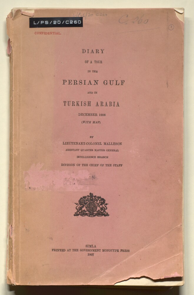
Abstract: Wilfrid Malleson,
Diary of a Tour in the Persian Gulf and in Turkish Arabia(Simla: Government Monotype Press, 1907). This is the diary of a tour in the Persian Gulf and Turkish Arabia by Lieutenant-Colonel Wilfrid Malleson, 7th-29th December, 1906. It describes his journey up the Persian Gulf from Muscat to Basra, Muhammerah [Khorramshahr], and onto Baghdad, including periods in quarantine stations as well as the competing shipping lines, types of boats, date trade, and life in Baghdad. Includes his description of life in Muscat for the British Consul and encounters with German and Russian diplomats.Includes 53 annotated photographs (ff 23-50) of the journey including views of Baghdad, Basra, Ctesiphon, and Musandam as well as two maps (ff 51-52).Physical description: Foliation: The foliation sequence commences at the front cover and terminates at the inside back cover; these numbers are written in pencil, are circled, and are located in the top right corner of the recto side of each folio (except for f 52, where the folio number is located on the verso). Pagination: The volume also contains an original printed pagination sequence.