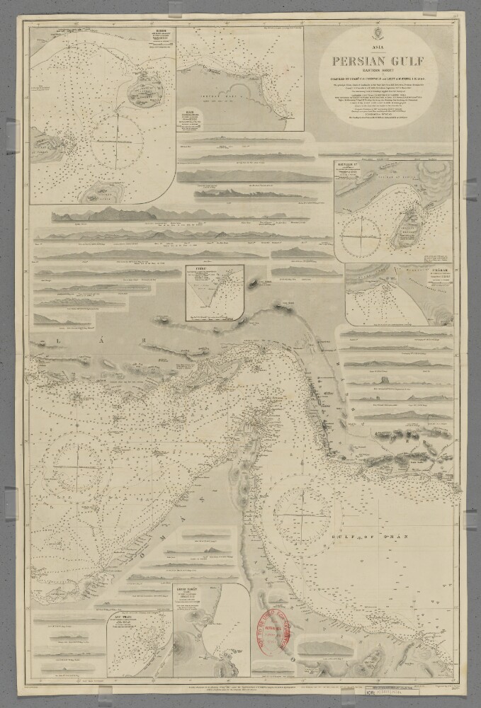
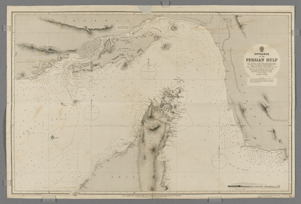
Abstract: Chart 2837a.Hydrographic chart covering the Strait of Hormuz and the adjoining sections of the Persian Gulf and Gulf of Oman. Also includes the adjacent coastal areas of Persia [Iran] and the Musandam Peninsula. Portrays hydrology, including depths by soundings and contours, anchorages, sands and rocks, relief by spot heights, hachures and rock drawings, vegetation, settlements, forts and place names, and includes topographical notes and navigational aids, including lights and prominent landmarks.Includes insets of Kishm, Persia [Qeshm, Iran] at scale 1:145,826; Kais to Bandar Abbas, Persia [Kish to Bander-e Abbas] at scale 1:72,913; Henjam Island, Persia [Hengam Island] at scale 1:145,826; Charak, Persia [Bandar-e Charak] at scale 1:145,826; Chiru, Persia [Bandar-e Chiruyeh] at scale 1:72,913; Khor Fakan, Oman [Khawr Fakkan, United Arab Emirates] at scale 1:60,760; and Abu Thabi, Trucial Oman [Abu Dhabi, United Arab Emirates] at scale 1:72,913.Thirty-three annotated sketches of significant navigational views at unspecified scales on both the north and south coasts are also included.Chart surveyed and compiled by Commander Charles Golding Constable and Lieutenant Arthur William Stiffe, Indian Navy (1860); also incorporates surveys by Captain John Michael Guy and Captain George Barnes Brucks, East India Marine (1821-1829); with corrections by Commander Frederic Henry Walter and Lieutenant H T Bowen, Royal Navy (1910). Engraved by J & C Walker. Published at the Admiralty 1862, with new editions 1865, 1890, 1910, 1911 and 1912, and small corrections.The sheet bears the stamps:'Not to be used for navigation. For reference purposes only' in red on the map face.The number '20.2' in black in the upper right margin.Physical description: Materials: Printed on paperDimensions: 960 x 636mm, on sheet 1003 x 665mm
Abstract: Imprint:Published by James Horsburgh, Hydrographer to the East India Company.Distinctive Features:Relief shown by hachures. Depth shown by soundings.Nautical chart of the Strait of Hormuz showing the Island of Kishm, Ormuz and Larrack and the eastern coast of the Ras Al Khaimah (Musandam Peninsula) north of Diba Al Fujairah with Jazirat al Maqlab (the Telegraph Island) omitted. Compiled from the surveys carried out by the Bombay Marine’s officers between 1820 and 1829.Includes an annotation on the survey with initials 'G.B.B.' [George Barnes Brucks].
Inscriptions:On recto, partially legible annotation in pencil in the bottom centre of sheet: ‘Alter these latitude’.Physical description: Dimensions:500 x 720 mm, on sheet 562 x 770 mm
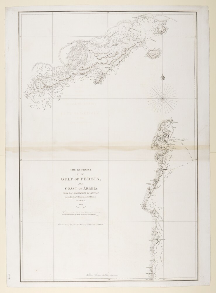
Abstract: Sheet 1 (Eastern) bears the shelfmark IOR/X/3635/1Sheet 2 (Western) bears the shelfmark IOR/X/3635/2Covers the Persian Gulf, Strait of Hormuz and the coastlines of Persia [Iran], Mesopotamia and the north-eastern Arabian Peninsula eastwards to the Musandam Peninsula. Includes a hinterland of approximately twelve miles. Portrays hydrology, including depths by soundings, and rocks, relief by hachures and rock drawing, vegetation, settlements and place names in English and Arabic, and includes topographical and hydrographic notes. The coastlines are highlighted in watercolour.'Constructed from the Trigonometrical Surveys. Made by Order of the Hon[ourab]le the Court of Directors of the United English East India Company; and to whom it is Respectfully Dedicated by their most obedient Servant George Barnes Brucks, Commander HC [Honourable Company] Marine. 1830.'Original surveys by Lieutenants John Michael Guy, George Barnes Brucks, Robert Cogan, William Eales Rogers and Stafford Bettesworth Haines, 1821-29. Engraved by Richard Bateman. Published by James Horsburgh, Hydrographer to the Honourable East India Company, 1832.Physical description: Materials: Printed, with manuscript additions in watercolour, on paper (backed with linen)Dimensions: Sheet 1 (Eastern) 725 x 580mm, on sheet 803 x 644mm; Sheet 2 (Western) 731 x 580mm, on sheet 820 x 648mm
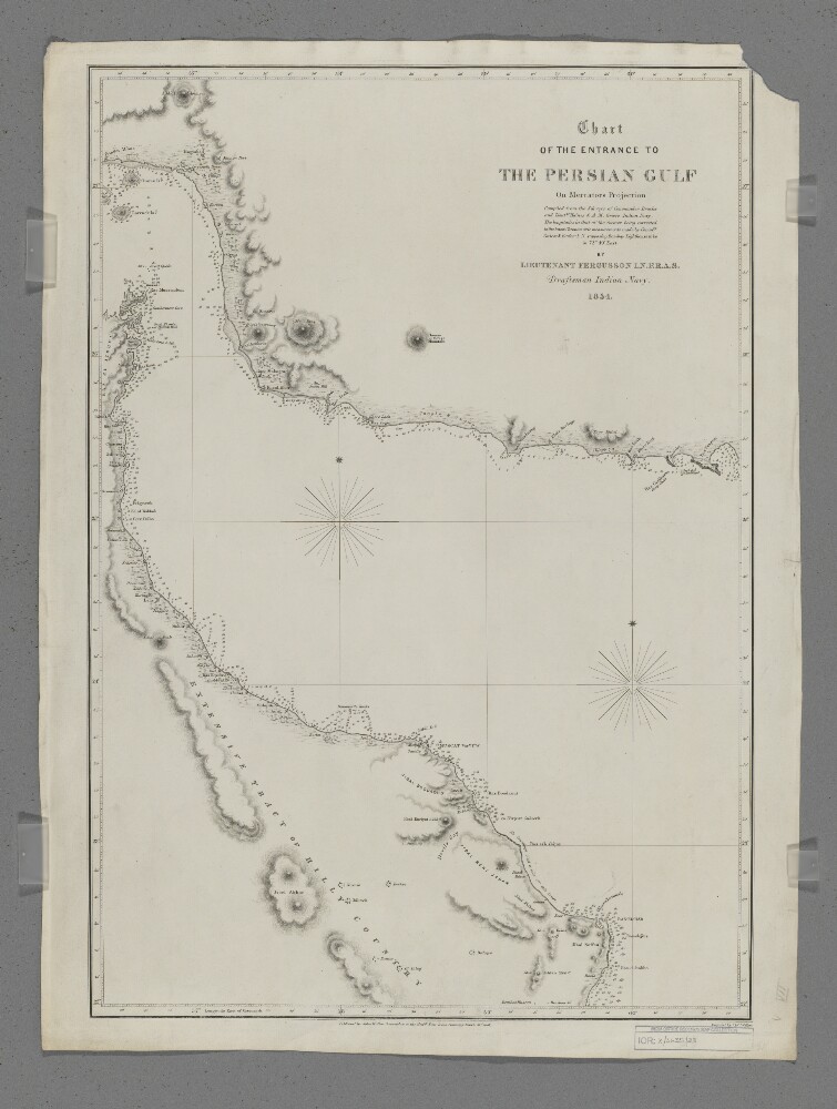
Abstract: Covers the eastern part of the Strait of Hormuz, the western part of the Gulf of Oman and the coastlines of southern Persia [Iran], northern Oman and the eastern side of the Musandam Peninsula, including a hinterland of approximately thirty miles. Portrays hydrology, including depths by soundings, sands and rocks, relief by hachures, rock drawing and occasional spot heights, vegetation, settlements, forts and place names, and includes topographical notes.Compiled by Lieutenant E F T Fergusson, Indian Navy from the surveys of Commander George Barnes Brucks and Lieutenants Stafford Bettesworth Haines and Albany Moore Grieve, Indian Navy, 1854. Engraved by J & C Walker. Published by John Walker, Geographer to the Honourable East India Company, 1857.Physical description: Materials: Printed on paperDimensions: 426 x 620mm, on sheet 678 x 508mm
Abstract: Sketch map attached to a report by Lieutenant Colonel Lewis Pelly related to the proposed extension of telegraph line, dated 31st Dec 1864.Distinctive Features:Relief shown by hachures.Shows the line of route with distances ‘calculated from the time actually employed in marching’. Districts labelled for reference with settlements and forts indicated by symbols; shoals represented by dots and crosses with anchorage marked. Report also includes ‘Itinerary of route from Bunder Abbas to Cape Jashk’ (folio 48).Physical description: Dimensions:532 x 441 mm, on sheet 575 x 500 mm
Abstract: Distinctive Features:Relief shown by hachures.Below title the note: Protracted by Mr [Edwin] Dawes, late Indian Navy, to accompany Colonel Pelly's despatch No.73 of 1864.Shows the line of route with distances ‘calculated from the time actually employed in marching’. Districts labelled for reference with settlements and forts indicated by symbols; shoals represented by dots and crosses with anchorage marked.Physical description: Dimensions:537 x 442 mm; on sheet 572 x 497 mmFoliation:The map sheet has been foliated in the front top right hand corner of the folio with a pencil number enclosed in a circle.
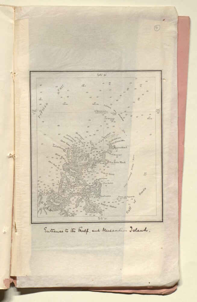
Abstract: Distinctive Features:Relief shown by hachures and spot heights. Depths shown by soundings.Nautical chart showing the entrance of the Persian Gulf and the Musandam Peninsula with details on hazardous features and tides given.Title inserted in hand below map.Physical description: Dimensions:170 x 145 mm, on sheet 340 x 200 mm
Abstract: Chart 753.Hydrographic chart covering the Strait of Hormuz and the adjoining sections of the Persian Gulf and Gulf of Oman. Also includes the adjacent coastal areas of Persia and the Musandam Peninsula. Portrays hydrology, including depths by soundings and contours, anchorages, sands and rocks, relief by spot heights and hachures, vegetation, settlements, forts and place names, and includes topographical notes and navigational aids, including buoys, beacons and prominent buildings.Includes an annotated sketch view, at unspecified scale, of Koh Mubarak, Persia [Kuh Mobarak, Iran] from the west by south at twelve miles distant.Chart produced from the surveys of Lieutenant John M Guy (1822), Commander George Barnes Brucks and Lieutenant Stafford Bettesworth Haines (1828) and Lieutenant Albany Moore Grieve (1839), Honourable Marine. Astronomical positions determined by Commander Charles Golding Constable and Lieutenant Arthur William Stiffe, Indian Navy (1857-60). Engraved by Davies, Bryer & Company. Drawn by Edward James Powell, Hydrographic Office. Published at the Admiralty, 1872.Physical description: Materials: Printed on paperDimensions: 640 x 968mm, on sheet 682 x 1017mm