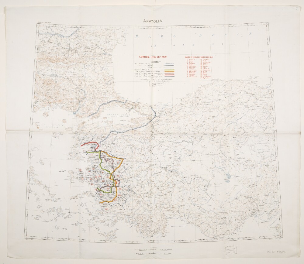
Abstract: Relates to the Treaty of Sèvres (1920)Created by the War Office August 1919 with boundaries added to 20 February 1920. Geographical Section, General Staff No. 2931, Sheet 'Anatolia'. Portrays hydrology, soundings, relief by spot heights and contours, railways, settlements, place names, and international and internal boundaries. Base map compiled from GSGS 2555 sheets NJ-35 (dated 1916), NJ-36 (1916), NK-35 (1919) and NK-36 (1916); projection information also derived from this source.Colour overprints, partly compiled from the information in folio 5, cover the Izmir (Smyrna) and Istambul [Istanbul] areas of western Turkey and depict boundaries of Vilayets, Sanjaks and Kazas; General Milne's Line; Line of Paris Greek Commission; Line of London Smyrna Commission; Line showing Greek claim of 19 February 1920; Line of Turkish Demilitarized Zone [Zone of the Straits]; and percentages of Races for complete Kazas, together with a list of Kazas.Verso bears the annotation 'Dardanelles'.Physical description: Materials: Printed in colour, with manuscript additions in pencilDimensions: 595 x 722mm, on sheet 713 x 830mm
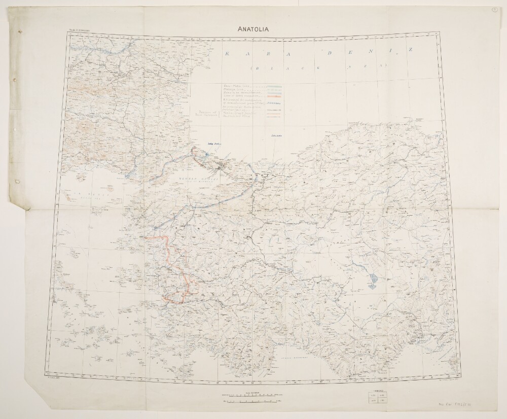
Abstract: Relates to the Treaty of Sèvres (1920).Created by the War Office August 1919 with boundaries and proposed boundaries added to 30 March 1920. Geographical Section, General Staff No. 2931, Sheet 'Anatolia'. Portrays hydrology, soundings, relief by spot heights and contours, railways, settlements, place names, and international and internal boundaries. Base map compiled from GSGS 2555 sheets NJ-35 (dated 1916), NJ-36 (1916), NK-35 (1919) and NK-36 (1916); projection information also derived from this source.Manuscript additions cover the Izmir (Smyrna) and Istambul [Istanbul] areas of western Turkey and depict the Enos-Midia Line; the Chatalja Line; the Zone to be demilitarised [Zone of the Straits]; the Line of Greek occupation; the W[ar]O[ffice] proposal for modification of demilitarised zone (11th March); the W[ar]O[ffice] proposal for Turko-Greek frontier (30 March 1920); the Turko-Greek frontier (as decided by Peace Conference); and the Neutralised Zone (as decided by Peace Conference). A small number of other features are also highlighted.Physical description: Materials: Printed in colour, with manuscript additions in pencil, crayon and coloured ink, on paperDimensions: 595 x 722mm, on sheet 713 x 860mm
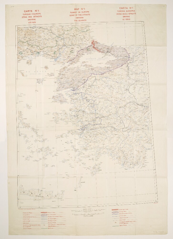
Abstract: Title also given in French (
Carte No. 1. Turquie d’Europe, Zône des Détroits, Smyrne, les Iles) and Italian (
Carta No. 1. Turchia Europea. Zona degli Stretti, Smirne, Le Isole).Relates to the Treaty of Sèvres (1920).Comprises a base map and overprints, and covers an area within an approximately 240-mile radius of Smyrna [Izmir] in western Turkey and extending north-westwards into Greece.The base map portrays hydrology, soundings, relief by spot heights and contours, railways, settlements, post and telegraph offices, place names, and international and internal boundaries. Bears the French imprint
Fond établi par le Service Géographique Britannique[Base map established by the British [army] Geographical Section]. North of 36⁰N the base is compiled from GSGS 2555 sheets NJ-35 (dated 1916), NJ-36 (1916), NK-35 (1919) and NK-36 (1916); south of this, map detail is coarser. Projection information is also derived from GSGS 2555.Colour overprints portray the Turkish border, Zone of the Straits, Smyrna Enclave, boundaries of vilayets, sanjaks and casas, islands attributed to Italy and the former frontier. Overprint legend in English, French and Italian. Bears the imprint
S[ervice].G[éographique de l']A[rmée]. 28 7.20.The verso bears the annotation 'Straits'.Physical description: Materials: Printed in colourDimensions: 830 x 633mm, on sheet 1070 x 745mm
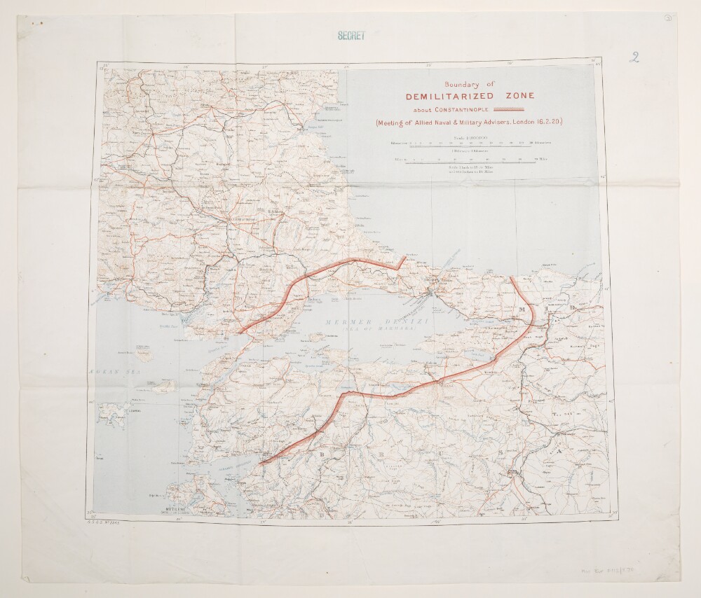
Abstract: Relates to the Treaty of Sèvres (1920).Folios 3 and 4 are copies of the same map, and both bear the classification 'Secret'.Geographical Section, General Staff No. 2943. Portrays hydrology, soundings, relief by spot heights and contours, railways, roads and tracks, telegraphs, settlements, place names, post and telegraph offices, and international and internal boundaries. Sheet compiled from GSGS 2555 sheets NJ-35 Izmir (Smyrna) (dated 1916), NJ-36 Konia (1916), NK-35 Istambul [Istanbul] (Constantinople) (1919) and NK-36 Sinob (1916) and originally produced by the Geographical Section, General Staff, War Office; projection information is derived from this source. The Boundary of the Demilitarized Zone [Zone of the Straits] has been added in red.Folio 3 bears the manuscript number '27'; folio 4 bears the manuscript number '2'.The verso of folio 3 bears the annotation 'The Straits'.Additional copies are filed at Maps X.1493. and Maps MOD 2943; neither bears a 'Secret' classification.Physical description: Materials: Printed in colour, with manuscript additions in crayonDimensions: 446 x 518mm, on sheet 570 x 558mm
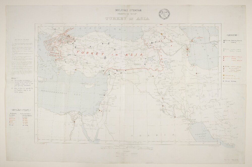
Abstract: Geographical Section, General Staff No. 2713b, comprising a base map with overprint and manuscript additions.The base map bears the deleted designation 'G.S.G.S. No. 2713a' and imprint 'War Office, Mar., 1916', and portrays hydrology, railways, roads, settlements, place names and international boundaries; marginal notes enhance railway information. A copy is at Maps 46970.(39.).An overprint in red bears the revised designation 'G.S.G.S. No. 2713b' and depicts revisions to international territories, including the extents of the Smyrna Enclave and Zone of the Straits. Manuscript additions portray the disposition of Turkish, Greek, Bolshevik, British, Georgian, Italian and French troops and are supplemented by a table of Fighting Strengths and some additional notes regarding troop dispositions. The sheet bears an acquisition stamp of 'M[ilitary].I[ntelligence]. 2.B.' dated 16 February 1921 and initialed 'AB Maj[or?]'.Physical description: Materials: Printed in colour, with manuscript additions in coloured inkDimensions: 434 x 722mm, on sheet 569 x 862mm
Abstract: Comprises a general purpose base map with overprints in red, blue and black. Sheet trimmed around the neatline and mounted on paper. Relates to the Treaty of Sèvres (1920).The base map portrays hydrology, relief by spot heights and gradient tints, roads, railways, settlements and place names. Railway information current to early 1890s.The red overprint portrays suggested post-war boundaries of Turkey, the Zone of the High Commissioner (Zone of the Straits) and lands to be ceded to Greece and Italy. The blue overprint depicts territory in which the Greeks form fifty per cent or more of the total population. The black overprint annotates land to be ceded to Greece together with a legend and explanatory note. The overprints are dated approximately 1920 and bear the imprint '1056-1'. A small pencil annotation occurs within the area ceded to Greece.Physical description: Materials: Printed in colour, with manuscript additions in pencilDimensions: 240 x 188mm, on sheet 340 x 218mm