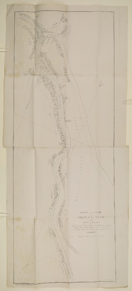
Abstract: Imprint:Lithographed in the Office of the Chief Engineer of P.W. by H Essoobyee, and F de Jesus, Bombay, 7 March 1857.Distinctive Features:Below title the note: 'by Captain Felix Jones, Resident Persian Gulf, and Captain M. Green, Sind Horse, constructed while reconnoitring the Enemy's position at Mahomerah [Khorramshahr] in Company with Commander Ethersey and Captain J.W. Young. J.N. in February 1857’.Shows the course of the Hugh Lindsay by blue line.The place names are given in English and Persian.Physical description: Dimensions:1130 x 425 mm; on sheet 1180 x 524 mm or smaller.Foliation: The map sheet has been foliated in the top right hand corner of the folio with a pencil number enclosed in a circle.
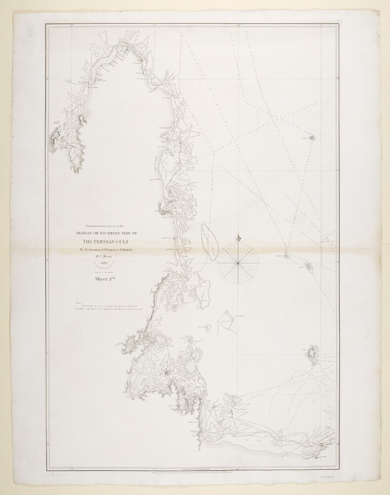
Abstract: Imprint:Published by James Horsburgh, Hydrographer to the East India Company.Distinctive Features:Relief shown by hachures. Depth shown by soundings.Nautical chart of the western coast of the Persian Gulf showing the Qatar Peninsula compiled from the surveys carried out by the Bombay Marine’s officers between 1820 and 1829.Shoals and rocks represented by crosses.Includes notes on latitude and longitude variations and sources used in compilation of the map.Physical description: Dimensions:798 x 521 mm, on sheet 861 x 676 mm
Abstract: The volume discusses the disputed Turco-Persian Frontier, particularly at Mohammerah, and the negotiations in Constantinople to attempt to settle it.The correspondence focuses on:the differences of opinion over the actual boundary at Mohammerah, including several maps demonstrating these differences;movements of Turkish and Russian troops;ownership of the Shat-el-Arab and questions of access for navigation;copies of treaties, correspondence and memoranda dating back to 1639 relating to the question of the Turco-Persian frontier.The principal correspondents in the volume are the Secretary of State for Foreign Affairs (Sir Edward Grey); the Secretary of State for India (Robert Offley Ashburton Crewe-Milnes, 1st Marquess of Crewe); the Political Resident in the Persian Gulf (Sir Percy Zachariah Cox); the British Ambassador to Constantinople (Sir Gerard Lowther); the British Ambassador to Russia (Sir George Buchanan); the Viceroy of India (Charles Hardinge, 1st Baron Hardinge of Penshurst); the British Ambassador to Tehran (Sir George Head Barclay); representatives of the Foreign Office (particularly Alwyn Parker) and the India Office; and Arthur Talbot Wilson, on special duty in relation to the Turco-Persian Frontier.This volume is part one of two. Each part includes a divider which gives the subject and part numbers, the year the subject file was opened, the subject heading, and a list of correspondence references contained in that part by year. This is placed at the back of the correspondence.Physical description: Foliation: the foliation sequence commences at the first folio with 1 and terminates at the last folio with 436; these numbers are written in pencil, are circled, and are located in the top right corner of the recto side of each folio.The foliation sequence does not include the front and back covers, nor does it include the leading and ending flyleaves.
Abstract: This file concerns tide tables relating to Bahrain, Bushire and other locations in the Gulf. It consists mostly of telegrams, memoranda, and brief letters of correspondence. Most of the file documents the efforts of the Political Agent, Bahrain, to obtain copies of tide tables for the Port of Bushire, Shatt al Arab, and the Port of Basrah [Basra].Correspondents include the following: the Political Agent, Bahrain (also spelled Bahrein in some of the correspondence); the Secretary to the Political Resident in the Persian Gulf, Bushire; the Survey of India’s Map Record Office, Dehra Dun [Dehradun]; the Director of Customs and Port Officer, Bahrain; the Port Director and Director-General of Navigation, Basrah; J D Potter (publishers and Admiralty chart agents); Lawrence and Mayo Ltd (opticians and Admiralty chart agents).Physical description: Foliation: the main foliation sequence (used for referencing) commences at the front cover with 1, and terminates at the inside back cover with 60; these numbers are written in pencil, are circled, and are located in the top right corner of the recto side of each folio. An additional foliation sequence is present in parallel between ff 4-57; these numbers are also written in pencil, but are not circled.
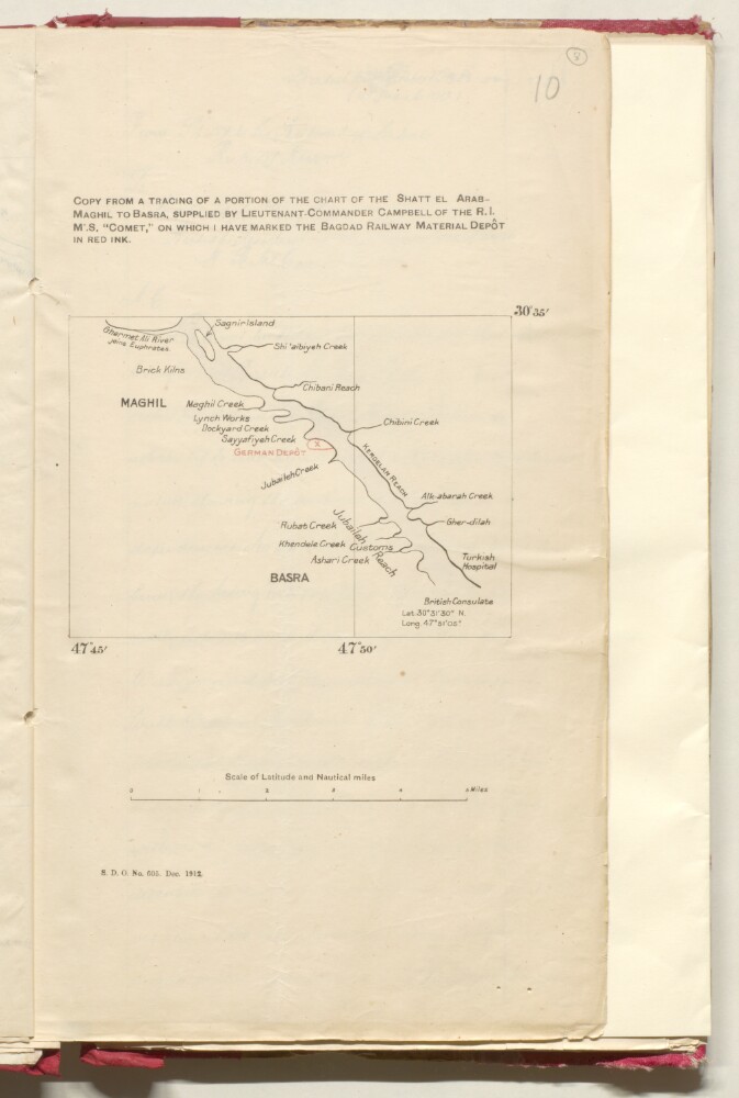
Abstract: Distinctive Features:Title continues: ‘ON WHICH I HAVE MARKED THE BAGDAD RAILWAY MATERIAL DEPÔT IN RED INK’. Rough plan showing Basra and environs with the location of German Depot and Customs indicated. British Consulate’s coordinates reported.In the bottom left-hand corner printed: ‘S.D.O. No. 605. Dec. 1912’.Physical description: Dimensions:345 x 210 mm
Abstract: Imprint:Published by James Horsburgh, Hydrographer to the East India Company.Distinctive Features:Relief shown by hachures. Depth shown by soundings.Nautical chart of the Arabian side of the Persian Gulf showing the coastline from Ras el Ghar with the Island of Bahrein and the western shores of the Qatar Peninsula compiled from the surveys carried out by the Bombay Marine’s officers between 1820 and 1829.Uqair in the Eastern province of Saudi Arabia labelled ‘Formerly Port to the Wahabee, Capital, Deriah’. Hawar Islands off the west coast of Qatar labelled ‘Wardens Islands’.Physical description: Dimensions:878 x 620 mm, on sheet 1019 x 677 mm
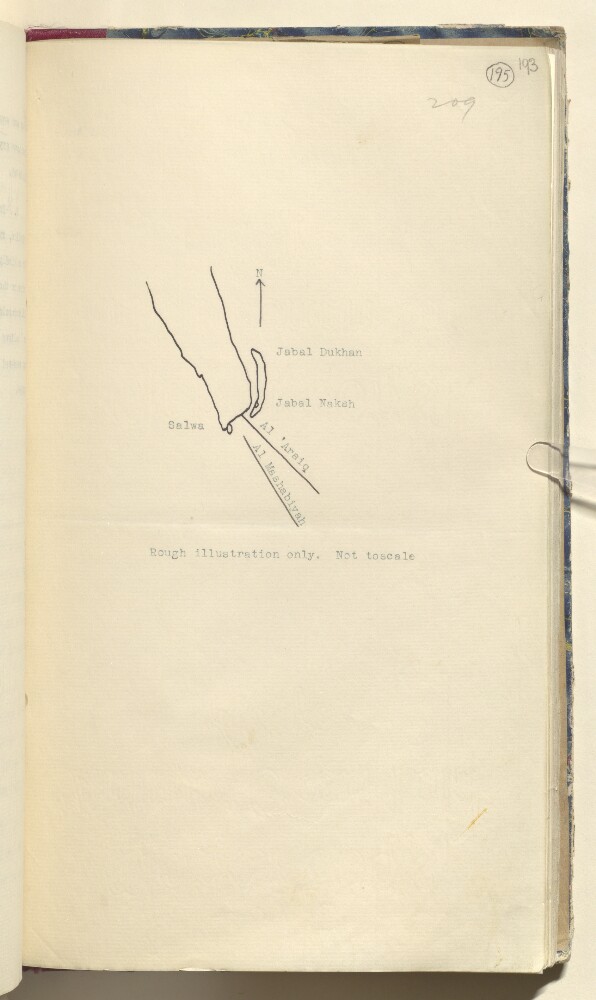
Abstract: Distinctive Features:Hand drawn sketch map showing Dawḩat Salwá and area west of Salwa, attached to a letter No. C/38-1.a/38 dated 25 January 1936, to illustrate a dispute concerning Saudi-Qatar boundary.Physical description: Materials:Pen and ink on paperDimensions:328 x 185 mm
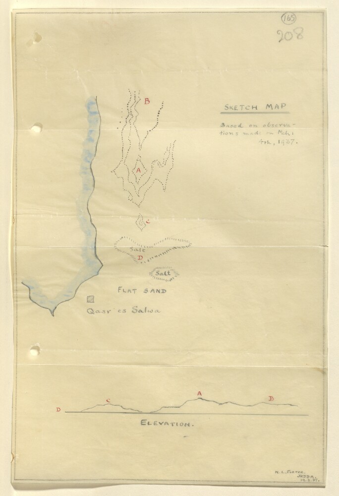
Abstract: Distinctive Features:Relief shown by hachures.Tracing of a rough sketch map based on observations made on 4th March 1937, showing area north of Qasr es Salwa in Qatar with landmarks lettered for reference. Includes corresponding elevation profile in the lower portion of sheet.Signed and dated in the bottom right-hand corner: ‘N.L. Forter, Jedda, 19.3.37’.Physical description: Materials:Pen and ink with wash on tracing paperDimensions:293 x 194 mm
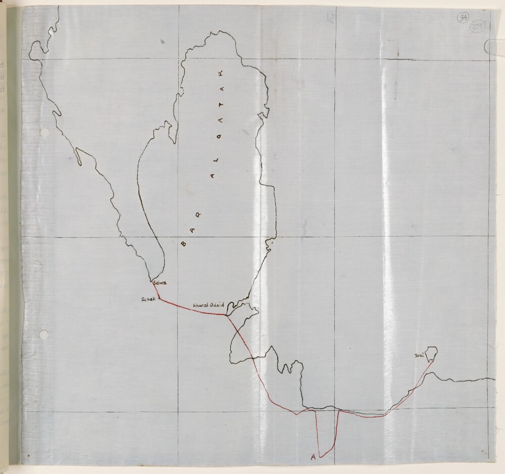
Abstract: Distinctive Features:Unsigned and undated.Hand-drawn map with the route of the Qatar Air Reconnaissance carried out by Lieutenant-Colonel Gordon Loch on 29th June 1934 shown by red line.Physical description: Materials:Pen and ink on tracing clothDimensions:322 x 335 mm
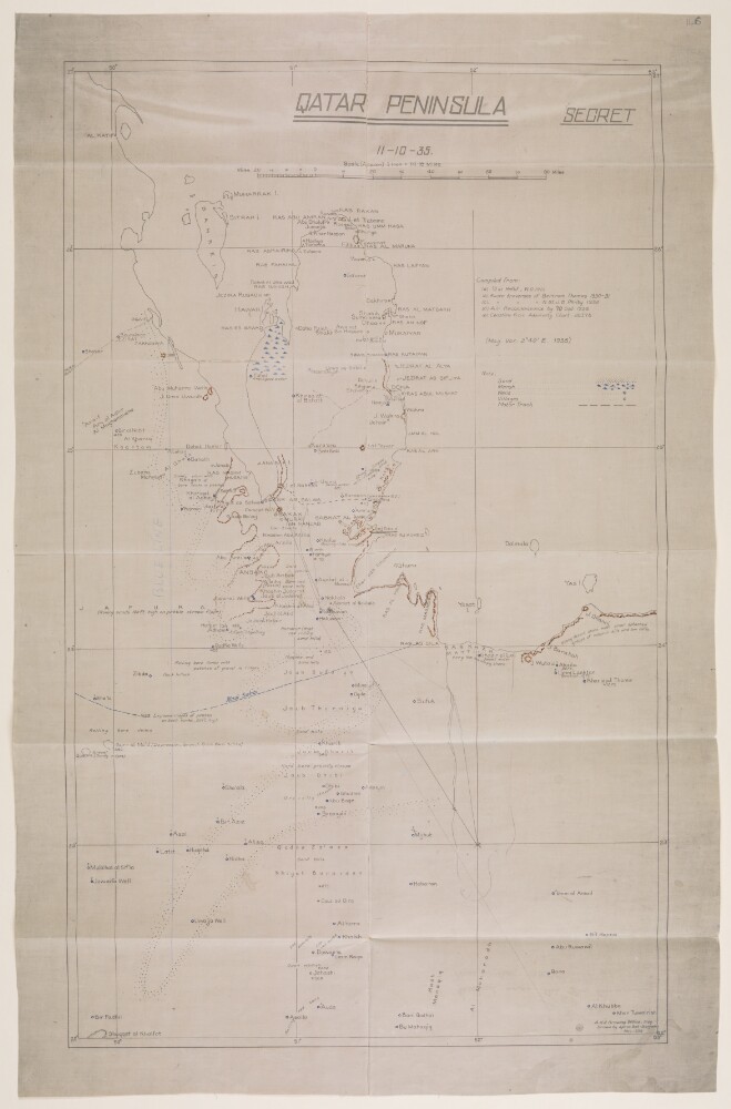
Abstract: Imprint:A.H.Q. [Air Headquarters] Drawing Office Iraq. Drawn by Aprim Bet-Benjamin, Nov. 1935.Distinctive Features:Relief shown by hachures.Map showing the Qatar Peninsula and central part of the Eastern Province Saudi Arabia. Numerous notations concerning terrain features cover the face of the map with routes, the location of wells with good water, and sandy and marshy areas marked.Includes a key to symbols and a list of sources used in compilation of the map.Inscriptions:On verso is an annotation in black ink: ‘Received under Air Officer Commanding, British forces in Iraq’s letter No. S. 10843/2411 dated 19th November 1935; file 61/31. With initials and date ‘12/12/35’.Physical description: Materials:Photographic print with additions in ink and crayon on tracing clothDimensions:592 x 357 mm, on sheet 670 x 431 mm
Abstract: The letter from Lieutenant-Colonel William George Grey to Sir Frederic Arthur Hirtzel encloses a copy of a letter No. C/8 of 1915 by Grey, as Political Agent in Kuwait, to the Political Resident in the Persian Gulf, dated 9 June 1915, regarding Arab co-operation with the Turks in the Shatt al-Arab [Shaṭṭ al-‘Arab] country.The letter refers to remarks made by Lord Curzon of Kedleston both in the House of Lords and in relation to an address given by Mr P Landon on Basrah and the Shatt al-Arab at the Society of Arts in April 1915. The remarks are regarding Arab tribes supporting the Turks, and further observations made by the Secretary of State for India on the Battle of Shaiba, at which it was reported that the Turkish troops had been joined by almost 10,000 Arab combatants. The letter also raises the question of why they were now siding with the Turks given their previous relations with Britain.Grey's response to these observations includes a detailed explanation of the composition of the tribes involved as being primarily from Arab communities in Iraq, and the Muntafiq [al-Muntafiq] tribe of the Euphrates and Shatt-ul-Gharaf [Shaṭṭ al-Gharrāf, also known as Shaṭṭ al-Ḥayy] regions. His response also notes that the tribes involved are not those of the Persian Gulf region as had previously been assumed by Lord Curzon.The letter goes on to explain these tribes' relations with the Turks and the reasons for their having sided with them. The letter concludes by providing information on some of the tribes of the Persian Gulf, in particular the Zaffir [al-Zafīr] who had declined Turkish invitations to take up arms; and the Yuarin, Bani Malik [Banī Mālik] and Shammar all of whom had chosen to remain neutral.Physical description: Foliation: The foliation for this description commences at folio 26 and terminates at folio 26, as it is part of a larger physical volume; these numbers are written in pencil, are circled, and are located in the top right corner of the recto side of each folio. An additional foliation sequence is also present in the volume; these numbers are also written in pencil, but are not circled, and can be found in the same position as the main sequence.
Abstract: The correspondence contained in the letter book relates primarily to affairs in Muscat from 1866 to 1868 during which time the Sultan of Muscat, Thuwaini bin Said died, allegedly killed by his son Salim II bin Thuwaini who subsequently seized power in Muscat before being overthrown in 1868 by his uncle Turki bin Said.Also covered in the correspondence are affairs relating to piracy in Bahrain 1867 to 1868 and the maritime peace treaties signed with various rulers in settling matters, including the treaty signed with Mohammed bin Thani, Chief of the Qatar tribes.Physical description: Foliation: The volume has been foliated in the top right hand corner of the recto of each folio with a pencil number enclosed in a circle.Pagination: The volume also contains original pagination in the first half of the volume which consists of an ink number in the top right hand corner of the recto and the top left hand corner of the verso of each folio. The numbers start on the first page of writing with 1 and runs to 177, located on the recto of folio 96.