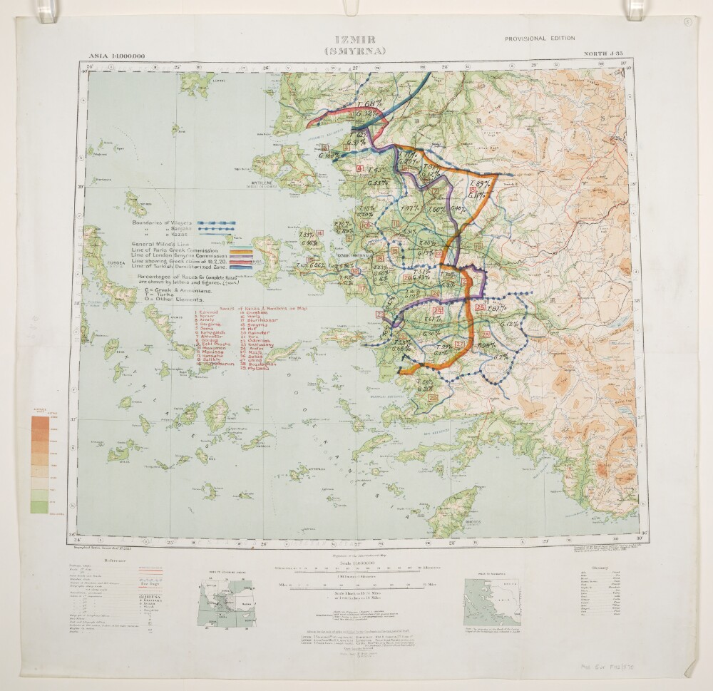
Abstract: Relates to the Treaty of Sèvres (1920).Geographical Section, General Staff No. 2555, Sheet North J-35, Izmir (Smyrna), Provisional Edition. Covers Izmir, western Turkey and surrounding land and sea areas to a radius of approximately 150 miles. Portrays hydrology, soundings, relief by spot heights and gradient tints, roads and tracks, railways, telegraphs, settlements, place names, post and telegraph offices, and international and internal boundaries. Bears the imprint 'Compiled at the Royal Geographical Society under the direction of the Geographical Section, General Staff. Drawn and printed at the War Office, 1916.'Manuscript annotations depict boundaries of Vilayets, Sanjaks and Kazas; General Milne's Line; Line of Paris Greek Commission; Line of London Smyrna Commission; Line showing Greek claim of 19 February 1920; Line of Turkish Demilitarized Zone; and percentages of Races for complete Kazas, together with a list of Kazas. The manuscript annotations have been used in the compilation of folio 6.Verso bears the annotation 'Smyrna Sanjak'.A copy of this map, without the annotations, is filed at Maps MOD GSGS 2555.Physical description: Materials: Printed in colour, with manuscript additions in coloured ink, watercolour and crayonDimensions: 446 x 541mm, on sheet 636 x 650mm
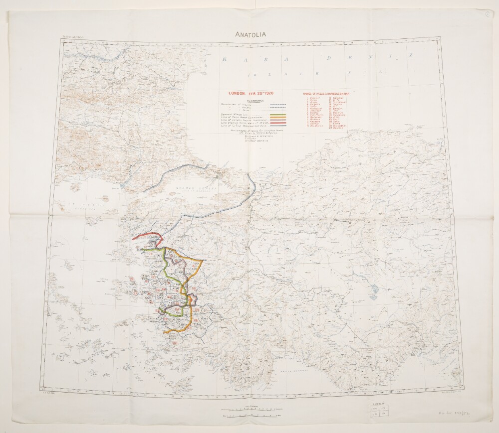
Abstract: Relates to the Treaty of Sèvres (1920)Created by the War Office August 1919 with boundaries added to 20 February 1920. Geographical Section, General Staff No. 2931, Sheet 'Anatolia'. Portrays hydrology, soundings, relief by spot heights and contours, railways, settlements, place names, and international and internal boundaries. Base map compiled from GSGS 2555 sheets NJ-35 (dated 1916), NJ-36 (1916), NK-35 (1919) and NK-36 (1916); projection information also derived from this source.Colour overprints, partly compiled from the information in folio 5, cover the Izmir (Smyrna) and Istambul [Istanbul] areas of western Turkey and depict boundaries of Vilayets, Sanjaks and Kazas; General Milne's Line; Line of Paris Greek Commission; Line of London Smyrna Commission; Line showing Greek claim of 19 February 1920; Line of Turkish Demilitarized Zone [Zone of the Straits]; and percentages of Races for complete Kazas, together with a list of Kazas.Verso bears the annotation 'Dardanelles'.Physical description: Materials: Printed in colour, with manuscript additions in pencilDimensions: 595 x 722mm, on sheet 713 x 830mm
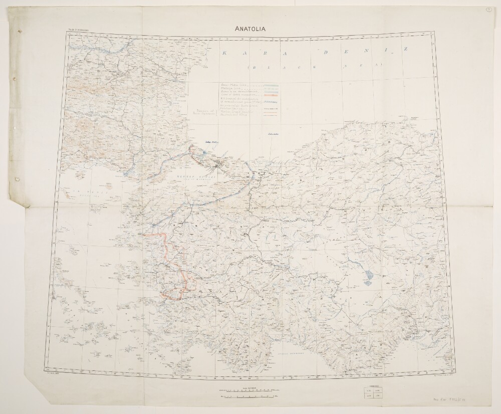
Abstract: Relates to the Treaty of Sèvres (1920).Created by the War Office August 1919 with boundaries and proposed boundaries added to 30 March 1920. Geographical Section, General Staff No. 2931, Sheet 'Anatolia'. Portrays hydrology, soundings, relief by spot heights and contours, railways, settlements, place names, and international and internal boundaries. Base map compiled from GSGS 2555 sheets NJ-35 (dated 1916), NJ-36 (1916), NK-35 (1919) and NK-36 (1916); projection information also derived from this source.Manuscript additions cover the Izmir (Smyrna) and Istambul [Istanbul] areas of western Turkey and depict the Enos-Midia Line; the Chatalja Line; the Zone to be demilitarised [Zone of the Straits]; the Line of Greek occupation; the W[ar]O[ffice] proposal for modification of demilitarised zone (11th March); the W[ar]O[ffice] proposal for Turko-Greek frontier (30 March 1920); the Turko-Greek frontier (as decided by Peace Conference); and the Neutralised Zone (as decided by Peace Conference). A small number of other features are also highlighted.Physical description: Materials: Printed in colour, with manuscript additions in pencil, crayon and coloured ink, on paperDimensions: 595 x 722mm, on sheet 713 x 860mm
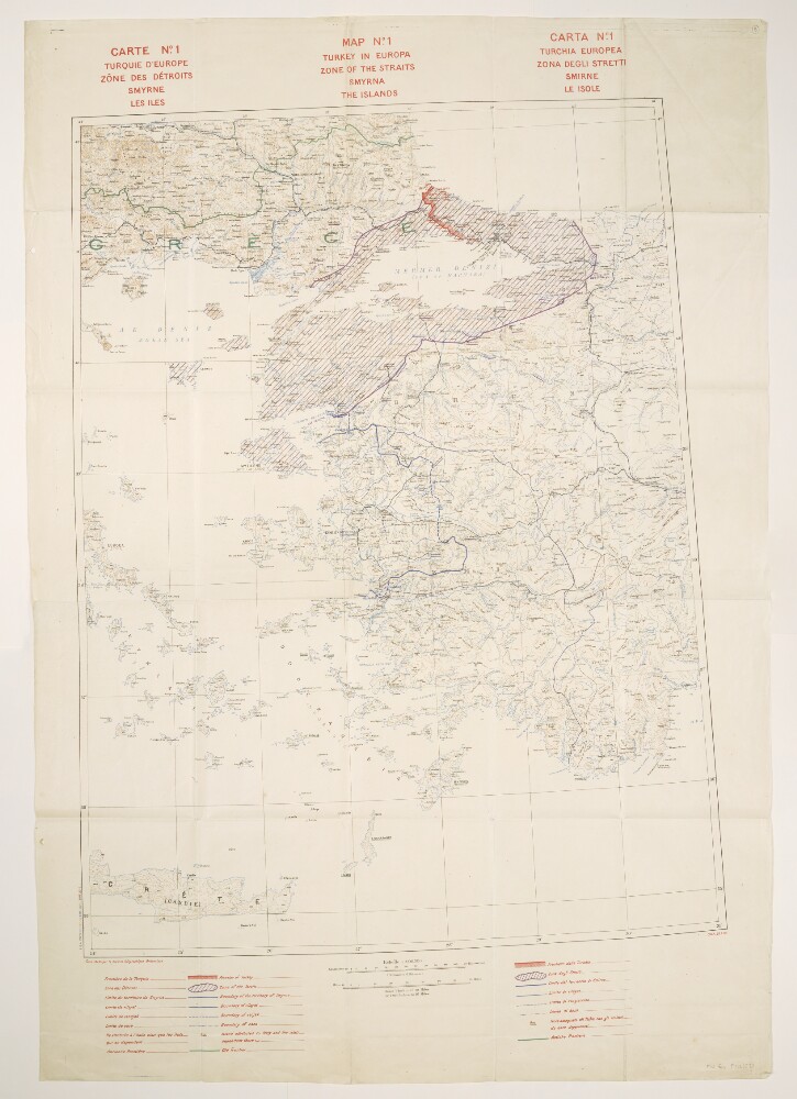
Abstract: Title also given in French (
Carte No. 1. Turquie d’Europe, Zône des Détroits, Smyrne, les Iles) and Italian (
Carta No. 1. Turchia Europea. Zona degli Stretti, Smirne, Le Isole).Relates to the Treaty of Sèvres (1920).Comprises a base map and overprints, and covers an area within an approximately 240-mile radius of Smyrna [Izmir] in western Turkey and extending north-westwards into Greece.The base map portrays hydrology, soundings, relief by spot heights and contours, railways, settlements, post and telegraph offices, place names, and international and internal boundaries. Bears the French imprint
Fond établi par le Service Géographique Britannique[Base map established by the British [army] Geographical Section]. North of 36⁰N the base is compiled from GSGS 2555 sheets NJ-35 (dated 1916), NJ-36 (1916), NK-35 (1919) and NK-36 (1916); south of this, map detail is coarser. Projection information is also derived from GSGS 2555.Colour overprints portray the Turkish border, Zone of the Straits, Smyrna Enclave, boundaries of vilayets, sanjaks and casas, islands attributed to Italy and the former frontier. Overprint legend in English, French and Italian. Bears the imprint
S[ervice].G[éographique de l']A[rmée]. 28 7.20.The verso bears the annotation 'Straits'.Physical description: Materials: Printed in colourDimensions: 830 x 633mm, on sheet 1070 x 745mm
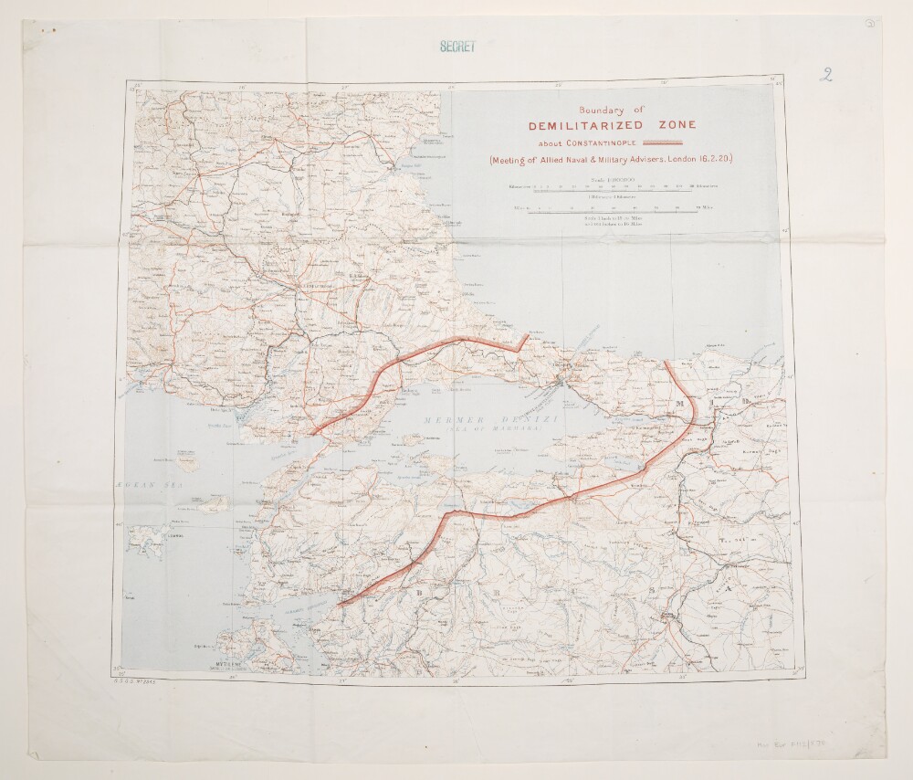
Abstract: Relates to the Treaty of Sèvres (1920).Folios 3 and 4 are copies of the same map, and both bear the classification 'Secret'.Geographical Section, General Staff No. 2943. Portrays hydrology, soundings, relief by spot heights and contours, railways, roads and tracks, telegraphs, settlements, place names, post and telegraph offices, and international and internal boundaries. Sheet compiled from GSGS 2555 sheets NJ-35 Izmir (Smyrna) (dated 1916), NJ-36 Konia (1916), NK-35 Istambul [Istanbul] (Constantinople) (1919) and NK-36 Sinob (1916) and originally produced by the Geographical Section, General Staff, War Office; projection information is derived from this source. The Boundary of the Demilitarized Zone [Zone of the Straits] has been added in red.Folio 3 bears the manuscript number '27'; folio 4 bears the manuscript number '2'.The verso of folio 3 bears the annotation 'The Straits'.Additional copies are filed at Maps X.1493. and Maps MOD 2943; neither bears a 'Secret' classification.Physical description: Materials: Printed in colour, with manuscript additions in crayonDimensions: 446 x 518mm, on sheet 570 x 558mm
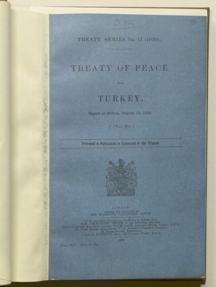
Abstract: A treaty of peace signed by the members of the League of Nations and Turkey.The treaty is divided into a preamble followed by 13 parts. Part 1 constitutes the Covenant of the League of Nations; further parts are entitled:'Frontiers of Turkey'.'Political Clauses'.'Protection of Minorities'.'Military, Naval and Air Clauses'.'Prisoners of War and Graves'.'Penalties', 'Financial Clauses'.'Economic Clauses'.'Aerial Navigation'.'Ports, Waterways and Railways'.'Labour'.'Miscellaneous Provisions'.3 maps are located at the back (f 62), and the whole is contained within the original front and back covers (f 11 and f 63).Published under the title
Treaty Series No 11 (1920), Cmd. 964.Physical description: Foliation: the main foliation sequence (used for referencing) commences at folio 11 and terminates at folio 63, as it is part of a larger physical volume; these numbers are written in pencil, and are located in the top right corner of the recto side of each folio.An additional foliation sequence is present in parallel between ff 11-62; these numbers are also written in pencil, but are circled and crossed through.
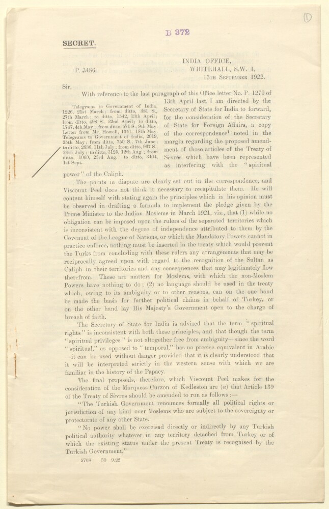
Abstract: This secret printed memorandum is a copy of a letter from Sir Frederic Arthur Hirtzel, India Office, to the Under Secretary of State, Foreign Office, dated 13 Sep 1922, concerning the proposed amendment of the articles of the Treaty of Sévres which have been represented as interfering with the 'spiritual power' of the Caliph. The letter is accompanied by a section of enclosures (folios 2-5) which includes fourteen enclosures consisting of various telegrams between the Secretary of State and the Viceroy of India, the Foreign Secretary of the Government of India and the India Office dated between 21 March 1922 and 1 September 1922. Enclosure No 7 includes an annex which is a minute entitled 'The Caliph's Religious Position' by Sir Muhammad Shafi.Physical description: Foliation: The foliation sequence commences at the front cover, and terminates at the inside back cover; these numbers are written in pencil, are circled, and are located in the top right corner of the recto side of each folio.Pagination: The volume also contains an original printed pagination sequence.
Abstract: Comprises a general purpose base map with overprints in red, blue and black. Sheet trimmed around the neatline and mounted on paper. Relates to the Treaty of Sèvres (1920).The base map portrays hydrology, relief by spot heights and gradient tints, roads, railways, settlements and place names. Railway information current to early 1890s.The red overprint portrays suggested post-war boundaries of Turkey, the Zone of the High Commissioner (Zone of the Straits) and lands to be ceded to Greece and Italy. The blue overprint depicts territory in which the Greeks form fifty per cent or more of the total population. The black overprint annotates land to be ceded to Greece together with a legend and explanatory note. The overprints are dated approximately 1920 and bear the imprint '1056-1'. A small pencil annotation occurs within the area ceded to Greece.Physical description: Materials: Printed in colour, with manuscript additions in pencilDimensions: 240 x 188mm, on sheet 340 x 218mm
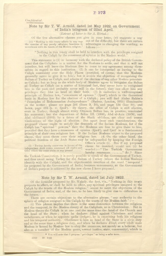
Abstract: This confidential printed memorandum contains three notes, dated 1 May 1922, 1 July 1922 and August 1922, by orientalist Sir Thomas Walker Arnold concerning the 'spiritual power' of the Caliph in the context of the proposed amendment of the articles of the Treaty of Sévres. The first note examines the wording of a certain clause and discusses the Islamic concept of 'consensus of opinion' (
ijmā‘); the second note discusses further the wording of a certain clause, specifically the phrase 'any authority in the sphere of religion assigned to the Caliph'; and the third note discusses the Arabic translation of the term 'spiritual rights and privileges' (al-huquq wal imtiyazat al-diniyah [
al-ḥuqūq wa al-imtiyāzāt al-dīnīyah]).Physical description: Foliation: The foliation sequence commences at the front cover, and terminates at the inside back cover; these numbers are written in pencil, are circled, and are located in the top right corner of the recto side of each folio.Pagination: The volume also contains an original printed pagination sequence.
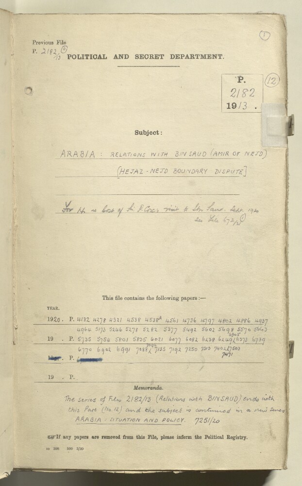
Abstract: Part 12 concerns British policy regarding the dispute between Bin Saud [‘Abd al-‘Azīz bin ‘Abd al-Raḥmān bin Fayṣal Āl Sa‘ūd, also referred to in the correspondence as Ibn Saud] and King Hussein of Hejaz [Ḥusayn bin ‘Alī al-Hāshimī, King of Hejaz]. Much of the correspondence relates to (unsuccessful) efforts by the British to arrange a meeting between the two rulers. The correspondence discusses conditions and arrangements for a proposed meeting at Mecca (as suggested by Bin Saud), immediately after pilgrimage [Hajj].The correspondence goes on to discuss details of an armistice agreement made between King Hussein's committee and the Nejd deputation, at Mecca. A translation of the agreement states that the two parties agree to end all hostile movements and resume negotiations as soon as possible through the British government.Also included are the following:details of a proposed gift of £5000 from the British government to Bin Saud (plus an honorary GCIE – Knight Grand Commander of the Order of the Indian Empire);proposals of a payment of £30,000 by the British government to King Hussein, on the condition that the King signs a treaty with Turkey [the Treaty of Sèvres, which began the partitioning of the Ottoman Empire];a copy (in Arabic) of the aforementioned Treaty;news of reports that King Hussein's son, Sherif Feisal [Fayṣal bin Ḥusayn bin ‘Alī al-Hāshimī, also referred to in the correspondence as Amir Feisal], has been crowned King of Syria, and copies of translations of correspondence between Feisal and Bin Saud.The item includes the following principal correspondents:Secretary to the India Office's Political Department (John Evelyn Shuckburgh);Civil Commissioner, Baghdad [held in an officiating capacity by Lieutenant-Colonel Arnold Talbot Wilson];High Commissioner, Egypt (General Edmund Henry Hynman Allenby);Political Agent, Bahrain (Major Harold Richard Patrick Dickson);Foreign Office;War Office;Treasury;Bin Saud.Physical description: 1 item (223 folios)
Abstract: This part contains correspondence between British officials, primarily in the Colonial Office, concerning the potential implications of the Treaty of Sevres for the Arabian peninsula, particularly in regards to the future political status of Yemen and Asir.Physical description: 1 volume (12 folios)