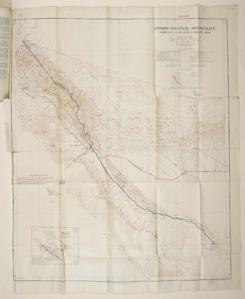
Abstract: Printed map with hand drawn additions. The map is signed by Captain Guy Bomford, Royal Engineers, and Superintendent of the Survey of India. A note at bottom of the map states that it was published under the direction of Brigadier Robert Henry Thomas, Surveyor General of India, in 1932. The B.P. referred to in the map’s title stands for boundary pillar. The map indicates: boundaries (international, state, district); railway lines; telegraph lines; roads, tracks, and other paths; hydrology; topography, with some indication of relief and heights expressed in feet; settlements; structures (including forts, watchtowers, mosques); post and telegraph offices. In the bottom left corner of the map is an inset map of Mīrjāwa [Mīrjāveh] (scale: 1:31,680), showing town, river, railways, roads, telegraph line. In the bottom right of the map is the printing statement: ‘Heliozincographed at the Survey of India Offices, Dehra Dūn [Dehradun].’The map’s hand drawn additions were made by Bomford. They are three additional frontier lines marked on the map, with accompanying key: 1) the Holdich Line, as transferred from the small scale map accompanying Thomas Hungerford Holdich’s agreement, with a correction to the Longitude measurement (blue dashed line); 2) a line considered to be the closest interpretation of the Holdich Agreement (solid blue line); and 3) an alternative interpretation of the Holdich Agreement (gold line). These additions are signed by Bomford.Two maps that follow on folios 116 and 117 are identical to this map, with the exception that they do not include Bomford’s hand drawn additions.Physical description: Dimensions:895 x 750 mm, on sheet 975 x 785 mm.Materials:printed on paper.
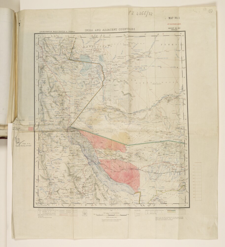
Abstract: Printed map with hand drawn additions. The map has two subtitles at its top: ‘Afghānistan, Baluchistān & Persia’ and ‘Sheet No. 30 Sīstān’, and is also labelled ‘Map No. 1, 2nd Edition (1928)’. It was published under the direction of Colonel Sir Sidney Gerald Burard, Surveyor General of India, 1918. The printed map indicates: hydrology; topography, with contours and heights; settlements; roads and railways; boundaries (international, province/state, district/tribal).The hand drawn additions to the map, with accompanying key, were made and signed by Captain Guy Bomford of the Royal Engineers and Superintendent of the Survey of India. They are: vertical blue lines indicating the area covered by the Indian Survey of 1932; horizontal blue lines indicating the Persian survey up to 11 May 1932; and solid pink regions indicating uninhabitable areas.The map is referred to in a copy of a secret letter from Bomford to the Surveyor General of India, dated 7 June 1932 (ff 113-114).Physical description: Dimensions:460 x 410 mm, on sheet 605 x 540 mm.Materials:printed on paper, with ink additions.
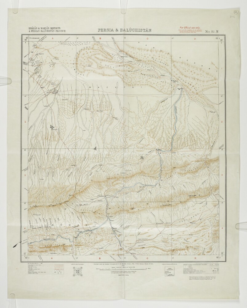
Abstract: Map of part of the territory on the Persia [Iran] and Baluchistan (part of present-day Pakistan) frontier, published under the direction of Colonel Sir Sidney Gerald Burrard, Surveyor General of India, 1915. The map indicates: relief, with form lines; hydrology; roads; settlements; boundaries, including the boundary between Persia and Baluchistan.The map accompanies papers and correspondence dated 1935 that relate to a dispute between the British and Persian Governments over the position of the border around Kuhak [Nūk Jow], Persia. The map is specifically referred to in a Foreign Office minute dated 20 December 1935, entitled ‘Alleged Intrusion of British Levies into Persian Territory near Kuhak.’ (ff 220-221).Physical description: Dimensions:460 x 420 mm, on sheet 590 x 476 mm.Materials:Printed in colour on paper.
Abstract: Map of the Bombay Presidency of British India, divided into Divisions (in pink) and Agencies (in yellow), which are further divided into Commissionerships and States respectively. The map also indicates hydrology, topography, settlements and railways.The following statement appears with the title and scale: ‘Compiled from the latest materials & from information furnished by the Bombay Revenue Survey and Settlement Department, IN THE OFFICE OF THE SURVEYOR GENERAL OF INDIA, Calcutta [Kolkata], December, 1873.’The following statement appears at the bottom of the map: ‘Published under the direction of Colonel H. L. Thuillier, R.A., F.R.S., Surveyor General of India, SURVEYOR GENERAL’S OFFICE, CALCUTTA, JANUARY 1874.’Physical description: Materials: Printed in colour on paperDimensions: 928 x 661mm, on sheet 976 x 678mm
Abstract: Copy of a map showing the frontier region between Persia [Iran] and British Baluchistan [in present-day Pakistan], produced from a Survey of India map of Baluchistan. The map is marked as being a true copy by Lieutenant-Colonel R A Wahab, Survey Officer of the Perso-Baluch Boundary Commission, dated 5 April 1896. A note at the bottom of the map states that it was published under the direction of Colonel Charles Strahan, Royal Engineers, and Surveyor General of India, in June 1896. The map indicates: hydrology; settlements; desert areas; the frontier, as a solid red and green line; numbered border posts along the frontier.Printing statements in the bottom right corner of the map read: ‘Photozincographed at the Office of the Trigonometrical Branch, Survey of India, Dehra Dún [Dehradun].’ and ‘Heliozincographed at the Survey of India Offices, Calcutta [Kolkata].’Physical description: Dimensions:530 x 405 mm.Materials:printed on paper.
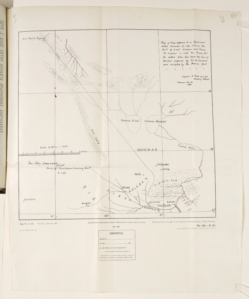
Abstract: Copy of a map showing Sir Henry Mortimer Durand’s proposed frontier between Persia [Iran] and British Baluchistan [in present-day Pakistan], referred to in the agreement of 27 December 1895 between the Governments of Persia and Britain. The original of the map was signed by Lieutenant-Colonel Henry Philip Picot, Military Attaché at Tehran, 30 December 1895. A note at the bottom of the map states that it was published under the direction of Colonel Charles Strahan, Surveyor General of India. The map indicates: the proposed frontier, shown as a black dashed line; hydrography; settlements; topography, with some indication of relief.The map is signed as being a true copy by Lieutenant-Colonel R A Wahab, Survey of the Perso-Baluch Boundary Commission, 5 April 1896. Printing statements in the bottom right corner of the map read: ‘Photozincographed at the Office of the Trigonometrical Branch, Survey of India, Dehra Dún [Dehradun]’ and ‘Heliozincographed at the Survey of India Offices, Calcutta [Kolkata].’Physical description: Dimensions:335 x 352 mm, on sheet 510 x 414 mm.Materials:Printed on paper.
Abstract: Map comprised of four Survey of India sheets stuck together, which were published under the direction of Colonel Sir Sidney Gerald Burard, Surveyor General of India, in 1915. The map shows the frontier region of British Baluchistan [in present-day Pakistan] through which the North Western Railway runs. The map indicates: hydrology; topography, with some indication of terrain; settlements; marked in pen, the route of the North Western Railway, with stops/stations; marked on coloured pencil, various boundaries: between Afghanistan and Baluchstan (green) between Persia [Iran] and Baluchistan (blue/red). A handwritten note at the bottom of the map states that the blue boundary line is that marked by Colonel Arthur Henry McMahon as corresponding to the Holdich Line agreed between Britain and Persia in 1896, and that the red line corresponds to that for which McMahon suggested Persian consent might be obtained.There is an illegible signature on the reverse of the map, dated 11 May 1916.Physical description: Dimensions:895 x 795 mm, on sheet 1035 x 860 mm.Materials:printed on paper, with ink and pencil additions.