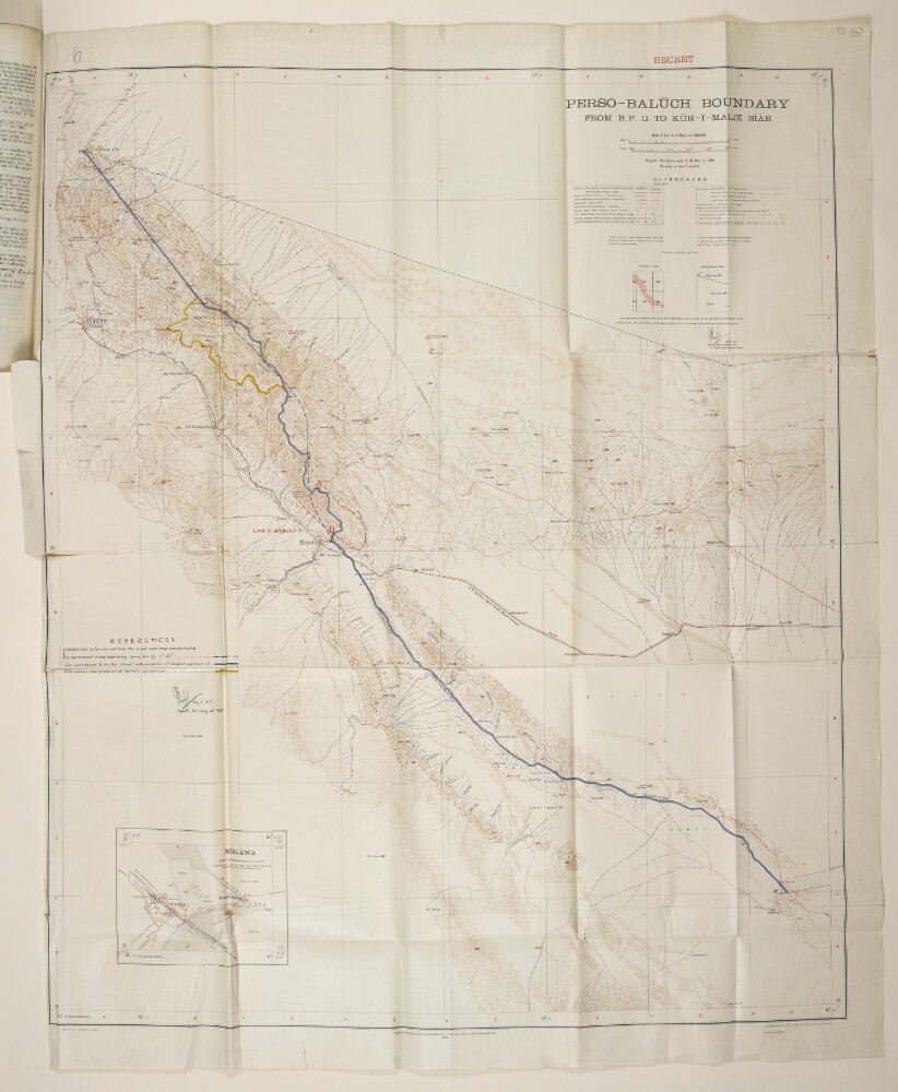
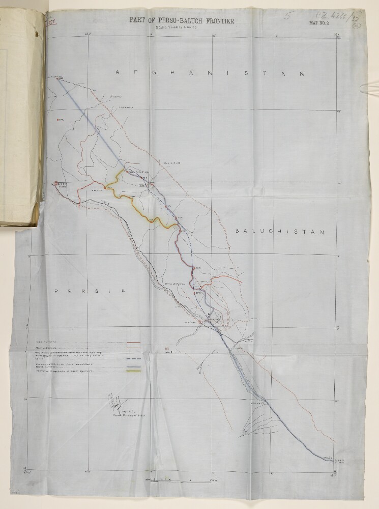
Abstract: Printed map with hand drawn additions. The map is signed by Captain Guy Bomford, Royal Engineers, and Superintendent of the Survey of India. A note at bottom of the map states that it was published under the direction of Brigadier Robert Henry Thomas, Surveyor General of India, in 1932. The B.P. referred to in the map’s title stands for boundary pillar. The map indicates: boundaries (international, state, district); railway lines; telegraph lines; roads, tracks, and other paths; hydrology; topography, with some indication of relief and heights expressed in feet; settlements; structures (including forts, watchtowers, mosques); post and telegraph offices. In the bottom left corner of the map is an inset map of Mīrjāwa [Mīrjāveh] (scale: 1:31,680), showing town, river, railways, roads, telegraph line. In the bottom right of the map is the printing statement: ‘Heliozincographed at the Survey of India Offices, Dehra Dūn [Dehradun].’The map’s hand drawn additions were made by Bomford. They are three additional frontier lines marked on the map, with accompanying key: 1) the Holdich Line, as transferred from the small scale map accompanying Thomas Hungerford Holdich’s agreement, with a correction to the Longitude measurement (blue dashed line); 2) a line considered to be the closest interpretation of the Holdich Agreement (solid blue line); and 3) an alternative interpretation of the Holdich Agreement (gold line). These additions are signed by Bomford.Two maps that follow on folios 116 and 117 are identical to this map, with the exception that they do not include Bomford’s hand drawn additions.Physical description: Dimensions:895 x 750 mm, on sheet 975 x 785 mm.Materials:printed on paper.
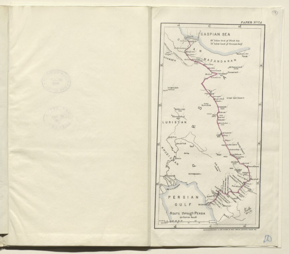
Abstract: Map of eastern Persia [Iran] marked paper no. 7A, and showing the route from Rasht to Bushire taken on horseback by Colonel August Le Messurier of the Bombay Engineers. The map indicates: the route taken, shown as a solid red line; major towns and cities on the route, with their elevations given in feet; the coastlines of the Caspian Sea and Persian Gulf; rivers. All the place names on the map have pencil ticks alongside them. The map’s scale is expressed in miles and farsakhs.The map bears a printed signature (illegible) in the bottom right corner, dated 28 November 1887. Under the map is the statement: ‘Photozincographed at the Survey of India Office, Calcutta, March 1888.’Physical description: Dimensions:283 x 145 mm, on sheet 334 x 375 mm.Materials:Ink on paper.
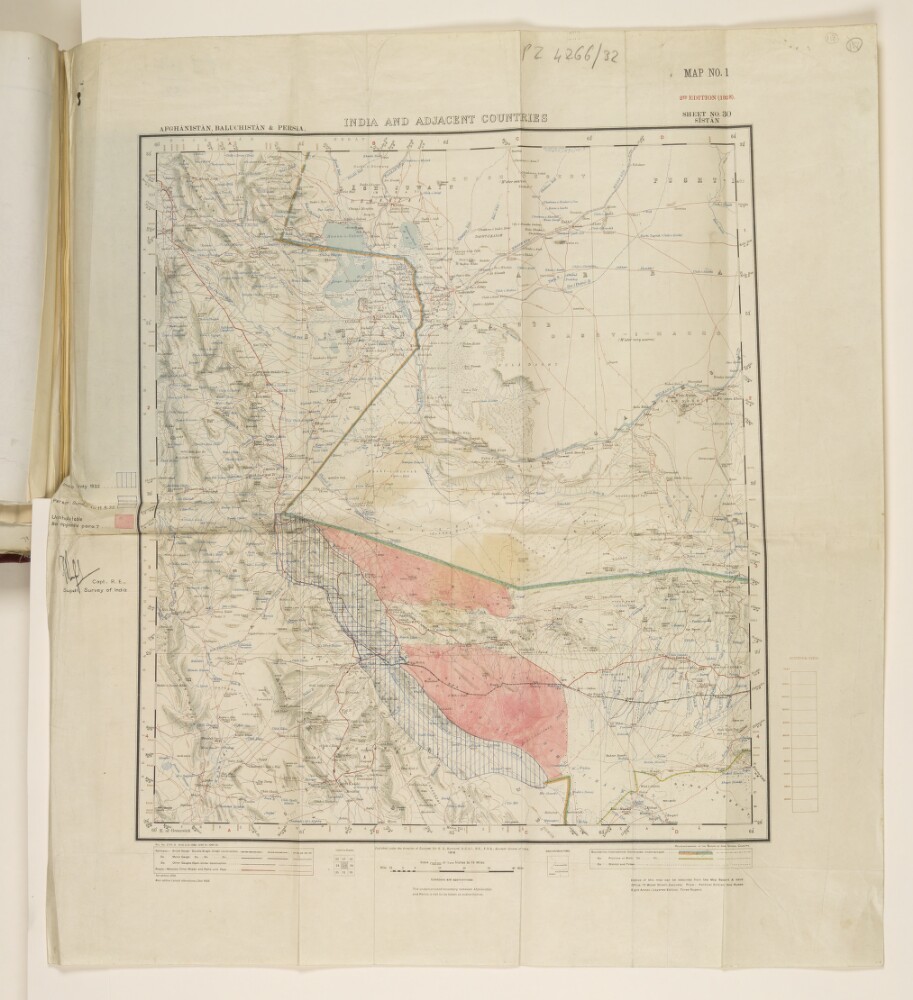
Abstract: Printed map with hand drawn additions. The map has two subtitles at its top: ‘Afghānistan, Baluchistān & Persia’ and ‘Sheet No. 30 Sīstān’, and is also labelled ‘Map No. 1, 2nd Edition (1928)’. It was published under the direction of Colonel Sir Sidney Gerald Burard, Surveyor General of India, 1918. The printed map indicates: hydrology; topography, with contours and heights; settlements; roads and railways; boundaries (international, province/state, district/tribal).The hand drawn additions to the map, with accompanying key, were made and signed by Captain Guy Bomford of the Royal Engineers and Superintendent of the Survey of India. They are: vertical blue lines indicating the area covered by the Indian Survey of 1932; horizontal blue lines indicating the Persian survey up to 11 May 1932; and solid pink regions indicating uninhabitable areas.The map is referred to in a copy of a secret letter from Bomford to the Surveyor General of India, dated 7 June 1932 (ff 113-114).Physical description: Dimensions:460 x 410 mm, on sheet 605 x 540 mm.Materials:printed on paper, with ink additions.
Abstract: This file contains a report by Mr George Passman Tate, the Extra Assistant Superintendent for the Survey of India, about the Seistan [Sistan] Mission. Tate details the ways in which the fieldwork was undertaken, and difficulties that were encountered. He also provides notes on communications (roads, fords and ferries) in Sistan. On folio 10, Tate outlines technical terms which are particular to Sistan and used in surveys carried out there. Between folios 11-12, there is a list of latitudes, longitudes, and heights of trigonometrical stations and points in Sistan.Physical description: Foliation: the foliation sequence for this description commences at the front cover with 1, and terminates at the inside back cover with 8; these numbers are written in pencil, are circled, and are located in the top right corner of the recto side of each folio.Pagination: the volume also contains an original printed pagination sequence.
Abstract: Secret map, marked ‘Map No. 2’ in the top right corner, showing the frontier region between Persia [Iran] and British Baluchistan [in present-day Pakistan]. The map indicates: hydrology, including main and minor watersheds as red lines; spot heights, indicated in feet; settlements; a railway line; the Holdich Line (blue dashed line) with Longitude correction; a line considered to be the closest interpretation of the Holdich Agreement (grey); an alternative interpretation of the Holdich Agreement (green). The map is signed by Captain Guy Bomford, Royal Engineers and Superintendent of the Survey of India.The map is referred to in a copy of a secret letter from Bomford to the Surveyor General of India, dated 7 June 1932 (ff 113-114).Physical description: Dimensions:670 x 475 mm, on sheet 760 x 550 mm.Materials:ink on parchment.
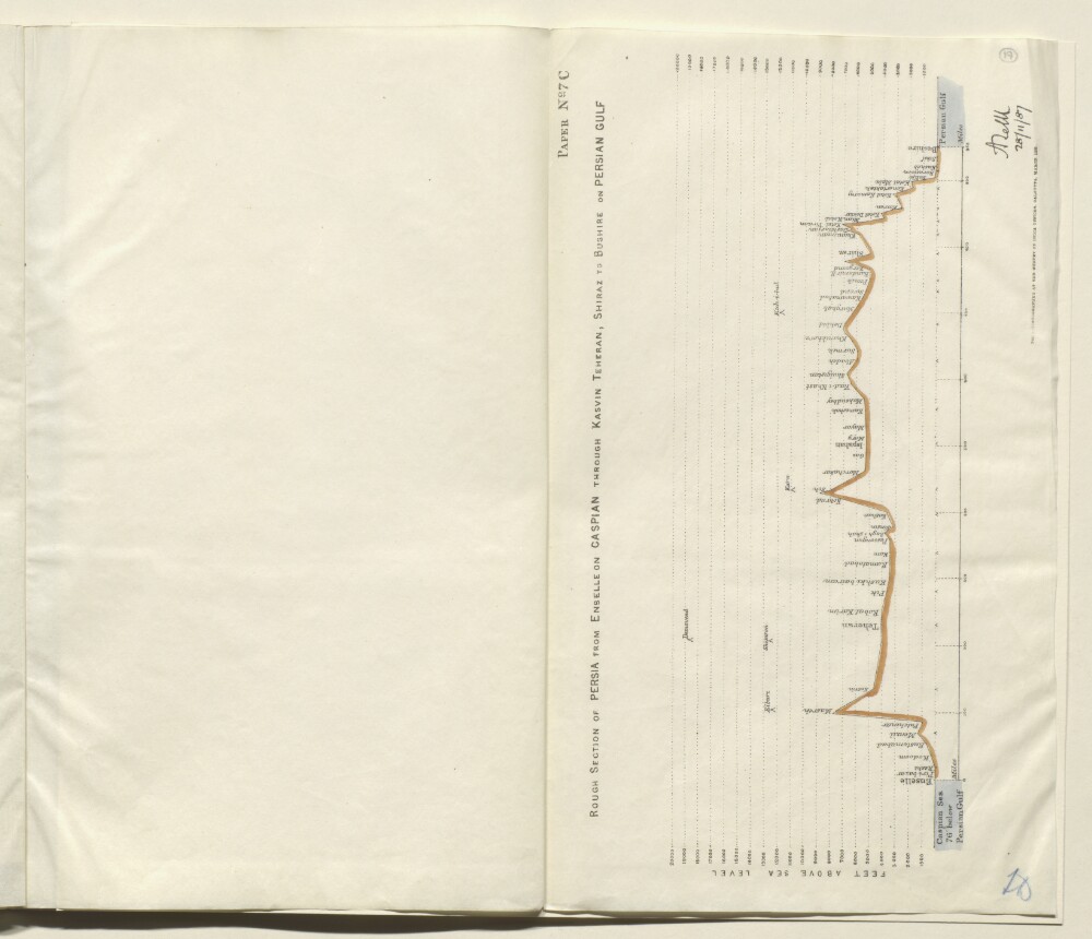
Abstract: Plan marked paper no. 7C, indicating the height above sea level (expressed in feet) of the route taken from Enselle [Bandar-e Anzalī] near Rasht, to Bushire, via Kasvin [Qazvin], Teheran [Tehran] and Shiraz, by Colonel Augustus Le Messurier of the Bombay Engineers, in 1887. The section is drawn as a solid black and red line, with the Caspian Sea on the left side of the plan, and the Persian Gulf on the right side. Towns and cities along the route are marked on the section. Significant mountains (for example, Demavend [Kūh-e Damāvand]) are also marked on the route.The plan bears a printed signature (illegible) in the bottom right corner, dated 28 November 1887. Under the plan is the statement: ‘Photozincographed at the Survey of India Office, Calcutta, March 1888.’Physical description: Dimensions:393 x 333 mm.Materials:Printed on paper.
Abstract: The volume serves as an index of places featured on Survey of India degree sheets 2C, 2D, 2G, 2H, 2K, 1L, 2O, 2P, 3A, 3E, 3I, 3J, 3M, 3N, 10A, 10B, and 10C. The places are arranged alphabetically and give the degree sheet reference.The preface details the method to be used to identify any given place on the degree sheets; occasions where the spelling given in the index varies from that given on the degree sheets; the method of transliteration used on the degree sheets; and instructions on pronunciation of certain letter combinations.Folios 59-63 are comprised of a glossary of geographic terms featured on the map sheets. The glossary was compiled by Major Charles Cecil Rowe Murphy of the 30th Punjabis.Published in Simla by the Government Central Branch Press, 1916.Physical description: Foliation: the foliation sequence commences at the front cover with 1, and terminates at the inside back cover with 65; these numbers are written in pencil, are circled, and are located in the top right corner of the recto side of each folio.
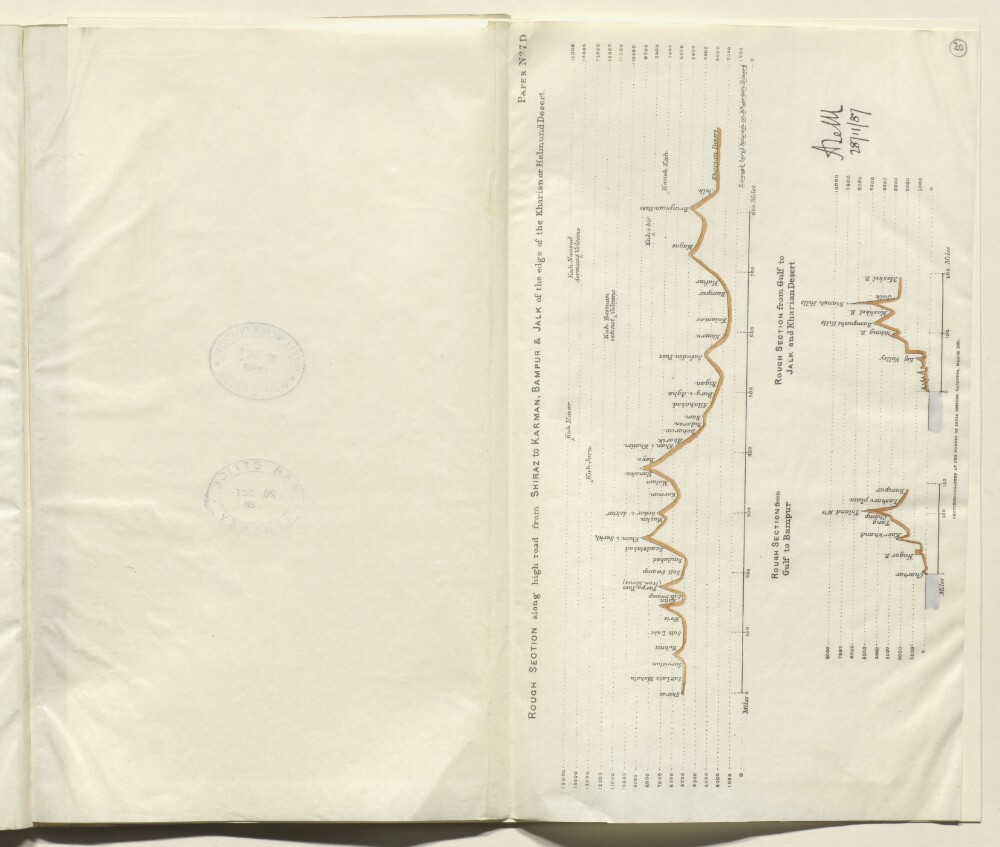
Abstract: Plan marked paper no. 7D, indicating the height above sea level (expressed in feet) of three sections of the route taken from Rasht to Bushire, by Colonel Augustus Le Messurier of the Bombay Engineers, in 1887. The three sections are as follows:rough section along the high road from Shiraz to Karman [Kerman], Bampur and Jalk [Jālq], at the edge of the Kharian Desertrough section from the Persian Gulf to Bampurrough section from the Persian Gulf to Jalk and the Kharian DesertThe sections are drawn as solid black and red lines. Towns and cities along the route are marked on the section. Significant mountains are also marked on the route. Varying vertical scales are used for the sections.The plans bear a printed signature (illegible) in the bottom right corner, dated 28 November 1887. Under the plan is the statement: ‘Photozincographed at the Survey of India Office, Calcutta, March 1888.’Physical description: Dimensions:393 x 333 mm.Materials:Printed on paper.
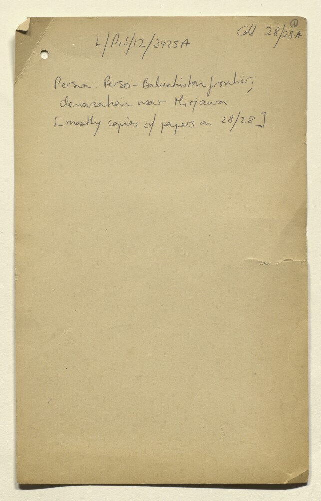
Abstract: Photographic reproductions of letters, memoranda, printed copies of correspondence and maps, relating to the demarcation of the border between Persia [Iran] and British Baluchistan (in present-day Pakistan) around the town of Mirjawa [Mīrjāveh]. The majority of the file’s papers are duplicates of material in the file Coll 28/28 ‘Persia. Perso-Baluchistan Frontier. Demarcation near Mirjawa.’ (IOR/L/PS/12/3425).Correspondence dating between 1924 and 1935 comprises the first part of the file (ff 2-153). The second part of the file is preceded by a cover slip attached to folio 154, which reads: ‘Collection ‘B’’. Papers in this part of the file (ff 154-286) comprise copies of correspondence dating between 1871 and 1912. Three of the file’s thirteen maps (f 223, f 224, f 242) are not duplicates of maps included IOR/L/PS/12/3425.Physical description: Foliation: the foliation sequence (used for referencing) commences at the front cover with 1, and terminates at the last folio with 286; these numbers are written in pencil, are circled, and are located in the top right corner of the recto side of each folio.