1 - 6 of 6
Number of results to display per page
Search Results
1. 'IRAQ AND THE PERSIAN GULF'
- Description:
- Abstract: The volume is titled Iraq and the Persian Gulf(London: Naval Intelligence Division, 1944).The report contains preliminary remarks by the Director of Naval Intelligence, 1942 (John Henry Godfrey) and the Director of Naval Intelligence, 1944 (E G N Rushbrook).There then follows thirteen chapters:I. Introduction.II. Geology and description of the land.III. Coasts of the Persian Gulf.IV. Climate, vegetation and fauna.V. History.VI. People.VII. Distribution of the people.VIII. Administration and public life.IX. Public health and disease.X. Irrigation, agriculture, and minor industry.XI. Currency, finance, commerce and oil.XII. Ports and inland towns.XIII. Communications.Appendices: stratigraphy; meteorological tables; ten historical sites, chronological table; weights and measures; authorship, authorities and maps.There follows a section listing 105 text figures and maps and a section listing over 200 illustrations.Physical description: Foliation: the foliation sequence (used for referencing) commences at the front cover with 1, and terminates at the inside back cover with 430; these numbers are written in pencil, are circled, and are located in the top right corner of the recto side of each folio.Pagination: the file also contains an original printed pagination sequence.
2. 'Persia Intelligence Report. May, 1946'
- Description:
- Abstract: The file consists of a copy of Persia Intelligence Report Part Vproduced by Naval Intelligence Division, Admiralty, May 1946.It is divided into three sections covering:the Persian Coast – providing figures of coastal distances, and a coast report consisting of a general description of the Persian Gulf and Caspian Sea, with more detailed descriptions broken down by section of the southern coast of Persia from Iraq to Baluchistan;the Persian Ports – information on individual Persian Gulf, Caspian Sea, and Lake Urmia ports. These include the following: Ābādān; Ahwāz [Ahvāz]; Asalū; Bandar Abbās; Bandar Shāpūr; Bushire; Chāhbār, Henjam [Henjān], Jāsk, Khorramshahr, Lingeh [Bandar-e-Lengeh], Astara, Babolsar, Bandar Shah, Mahmudabad, Naushah, Pahlevi, Shahsawar, Gurmeh Khaneh, Haiderabad [Hyderābād], and Sharif Khaneh;base facilities and maintenance of fleets in the Persian Gulf and Caspian Sea: summary – consisting of naval dockyards and bases, principal commercial dockyards and repair bases, oil storage and coal depots, and arsenals and war material factories.Physical description: Foliation: the foliation sequence commences at the front cover with 1, and terminates at the inside back cover with 40; these numbers are written in pencil, are circled, and are located in the top right corner of the recto side of each folio.Pagination: the file also contains an original printed pagination sequence.
3. ''Handbook of Mesopotamia. Vol. I. 1916''
- Description:
- Abstract: This volume is A Handbook of Mesopotamia, Volume I, General(Admiralty War Staff Intelligence Division: August 1916). It is an introductory volume containing matter of a general nature giving an account of conditions in Mesopotamia. The volume includes a note on official use, title page and ''Note''. There is a page of ''Contents'' and includes the following chapters and sections:Chapter 1: Boundaries and Physical Features;Chapter 2: Climate;Chapter 3: Minerals;Chapter 4: Fauna and Flora;Chapter 5: Hygiene;Chapter 6: History;Chapter 7: Inhabitants;Chapter 8: Religions;Chapter 9: Administration;Chapter 10: Irrigation of Irak Iraq;Chapter 11: Agriculture;Chapter 12: Commerce and Industry;Chapter 13: Currency, Weights and Measures;Chapter 14: Communication and Transport;Transliteration of Arabic, Persian and Turkish Names;Vocabularies;Index.There is a List of Maps which includes:Map 1: Administrative Divisions and Chief Towns;Map 2: Racial Divisions;Map 3: Area Available for Irrigation.Physical description: Foliation: The foliation sequence commences at the first folio and terminates at the last folio; these numbers are written in pencil, are circled, and are located in the top right corner of the recto side of each folio.Pagination: The volume also contains an original printed pagination sequence.

4. 'Handbook of Mesopotamia. Vol. I. 1918'
- Description:
- Abstract: This volume is A Handbook of Mesopotamia, Volume I, General(Naval Staff, Intelligence Department: November 1918). This is an updated and expanded edition of A Handbook of Mesopotamia, Volume I, General(Admiralty War Staff, Intelligence Department: August 1916) (IOR/L/MIL17/15/41/1). This is an introductory volume containing matter of a general nature giving an account of conditions in Mesopotamia, for the most part as they were before the First World War.The volume includes a note on official use, a title page and 'Note'. There is a page of 'Contents' that includes the following chapters and sections:Chapter 1: Boundaries and Physical Features;Chapter 2: Climate;Chapter 3: Minerals;Chapter 4: Fauna and Flora;Chapter 5: Hygiene;Chapter 6: History;Chapter 7: Inhabitants;Chapter 8: Religions;Chapter 9: Administration;Chapter 10: Irrigation of Irak [Iraq];Chapter 11: Agriculture and Land Tenure;Chapter 12: Commerce and Industry;Chapter 13: Currency, Weights, and Measures;Chapter 14: Communications and Transport;Vocabularies;Index.Physical description: Foliation: The foliation sequence commences at the first folio and terminates at the last folio; these numbers are written in pencil, are circled, and are located in the top right corner of the recto of the folio.Pagination: The volume also contains an original printed pagination sequence.
5. 'Handbook of Mesopotamia. Vol. II. 1917'
- Description:
- Abstract: This volume is A Handbook of Mesopotamia, Volume II, Irak, The Lower Kārūn, and Luristan(Admiralty War Staff Intelligence Division, May, 1917), covering the regions of the Shatt el-‘Arab [Shaṭṭ al-‘Arab], Kārūn, Luristan, and the Tigris and Euphrates up to Baghdad and Fellūjeh [Fallūjah]. The volume was prepared on behalf of the Admiralty and War Office, and appears to be based on official and unofficial publications and maps which are cited in a bibliographical section in the volume.The volume includes a note on confidentiality, a title page, 'Note', 'Abbreviations'. There is a 'Contents' which include the following sections:Introduction;River Routes (Shatt el-‘Arab, The Kārūn, The Tigris, The Euphrates, The Shatt el-Hai);Land Routes (The Region of the Shatt el-‘Arab, The Tigris Valley, The Region of the Lower Kārūn River of Luristan, The Euphrates Valley, Connexions between the Tigris and Euphrates Valley, The Arabian Desert);Railways;Gazetteer of Towns;Bibliographical Note and List of Maps;Transliteration of Names;Glossary;Appendices (A: Notes on Weather on the Tigris, B: The Control of the Tigris Water, C: The Control of the Euphrates Water, D: Oil-Fields of the Mesopotamia and Persian Frontier, E: Note on Mules);Index;Plates;Maps.The volume includes eight plates that illustrate the volume. There are also three maps:'Baghdad';'City Map of Baghdad';'Mesopotamia: Outline Map Showing Routes'.Physical description: Foliation: The foliation sequence commences at the first folio and terminates at the last folio; these numbers are written in pencil, are circled, and are located in the top right corner of the recto side of the folio.Pagination: The volume also contains an original printed pagination sequence.
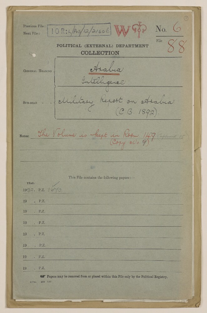
6. Coll 6/88 'Intelligence: Military Report on Arabia (C.B. 1892).'
- Description:
- Abstract: This file consists of two parts. The first part (folios 1-9) begins with a 'state of report' document for an Admiralty Naval Intelligence Division report entitled 'Arabia, Intelligence Report'; the 'state report' concerns the updating of the report in October 1941, and it includes a list of maps, plans and photographs that are contained in the report. There then follows a small amount of correspondence between India Office, War Office, and General Staff (India) officials regarding the supply of an earlier issue of the report, dated 1939.The second part of the file consists of the actual report, entitled 'C.B. 1892 (X) (10/41) Arabia Intelligence Report', dated October 1941, with appended maps, plans and photographs relating to Arabian Peninsula ports. The report is divided into four sections (six sections are listed in the table of contents, which lists sections one and three, most of section two, and one part of section five, as 'not issued', i.e. not printed in this edition of the report).The first section to appear in the report is entitled 'Section II: Strategy and Tactics'; parts 1 and 3-6 of this section have been omitted, leaving part 2, which has the heading 'Possible Lines on which War Plans would be Framed'.The next section, 'Section IV: Geography and Topography', provides an overview of the geography and topography of the Arabian Peninsula, including information about climate, transport facilities (including a table of landing grounds and seaplane anchorages), and communications.The third section, 'Section V: Base Facilities and Maintenance of the Fleet' (from which part one has been omitted), provides a summary of principal commercial dockyards and repair bases, locations for fuel storage, supplies and storage of ammunition, fixed coastal defences, and aircraft.The final section of the report, 'Section VI: Ports, Anchorages and Their Defences', proceeds through a number of Gulf ports in alphabetical order (i.e. Akaba, Bahrain, Doha, Hodeida and Ras Kethib, Jedda, Kamaran, Kuwait, Mukalla, and Muscat), describing each place's port facilities, anchorages and defences, as well as providing other information relating to matters such as government, commerce, water supply, transport and communications.Enclosed with the maps and plans is a symbols chart, which lists some of the symbols used in the maps and plans.Physical description: Foliation: The file is formed of two parts. The foliation sequence (used for referencing) commences at the front cover of the first part at 1 and terminates at the inside back cover of the second part at 65; these numbers are written in pencil, are circled, and are located in the top right corner of the recto side of each folio.