« Previous |
1 - 12 of 15
|
Next »
Number of results to display per page
Search Results
1. 'Reconnaissances in Mesopotamia, Kurdistan, North-West Persia, and Luristan from April to October 1888. By Lt F R Maunsell, Intelligence Branch. In Two Volumes. Volume I: narrative report, description of larger towns and routes leading from them. Simla: Intelligence Branch, Quarter Master General's Dept, 1890'
- Description:
- Abstract: Narrative report on surveys conducted in Mesopotamia [Iraq], North-West Persia [Iran] and Luristan [Lorestān]. The preface provides the following information:'The object was to explore various tracts of little known country through which roads lead north from the head of the Persian Gulf to the Waliat of Van and North-West Persia near Urmia. To accomplish this, two routes through Luristan from the Tigris valley were travelled. In southern Kurdistan the roads from Kifri to Sulaimaniah, from there to Rawanduz, and Rawanduz to Amadiyeh, were gone over in Turkey, and Suj-Bulak to Karmanshah through Sakiz and Sihna in Persia. The country south of lake Van to Mosul was traversed in the routes Amadiyeh to Mosul, Mosul to Jazirah, Jazirah to Bashkala, Bashkala to Urmia, and Urmia to Suj Bulak through Ushnu.'The report contains the following illustrations:Tak-i-Girra, looking east (f 42).Sketch showing the Town of Rawanduz [Rāwāndūz], (f 63).Sketch showing the bridge at Rawanduz. (f 66).Sketch showing Amadiyeh [Al 'Amādīyah] from the north-east, (f 76).Sketch showing the bridge of Mosul (f 85).The report contains the following maps:Pass of Tak-i-Girra, on the Baghdad-Kermanshah Route, December 1889 (f 41).Country in vicinity of Rawanduz, May 1889 (f 64).Plateau of Amadiyeh and surrounding country, June 1888 (f 74).Plan of Mosul and surrounding country, corrected from Jones' survey, August 1889, (f 87).Country between Feishkhabur [Fīsh Khābūr] and Zakho, June 1888, (f 101).Physical description: Foliation: the foliation sequence (used for referencing) commences at the front cover with 1, and terminates at the inside back cover with 154; these numbers are written in pencil, are circled, and are located in the top right corner of the recto side of each folio. Pagination: the file also contains an original printed pagination sequence.
2. 'The Illicit Trade in Arms and Ammunition Between the Persian Gulf and Afghanistan'
- Description:
- Abstract: The file consists of notes and appendices providing a history of the arms trade up to 1908, prepared by C M Gibbon of the Persian Section of the Intelligence Branch, Quarter Master General's Department, Government of India.A preface is included by Wilfrid Malleson, Division of Chief of General Staff, India.It discusses: the monetary value of the arms trade, attempts to stop the import of arms into Persia, reported trade routes, import and export figures, the types of rifles and ammunition imported, and firms connected with arms traffic.The appendices include the following:an outline of the scheme inaugurated by Mr New of the Indo-European Telegraph Department for the prevention of illicit arms trade on the Makran Coast;lists of arms caravans known to have made their way from the Makran Coast into Afghan territory;a precis of the action taken by the Persian Government to prohibit arms caravans through South-East Persia;statistics for the value of arms and ammunition openly imported in the Masqat [Muscat] and Persian Gulf ports, monthly exports from the United Kingdom, imports into Masqat by foreign vessels, distribution from Masqat to Persian and Arabian Coasts, and the proportion of various forms of rifles and ammunition imported monthly;a statement of the departures for and arrivals at Masqat of vessels carrying arms and ammunition, and European firms connected with Masqat arms traffic.Also includes one map on folio 17: 'PLAN TO ILLUSTRATE ROUTES TAKEN BY ARMS CARAVANS BETWEEN THE MAKRAN COAST and the AFGHAN BORDER'Physical description: Foliation: the main foliation sequence (used for referencing) commences at the front cover with 1, and terminates at the inside back cover with 18; these numbers are written in pencil, are circled, and are located in the top right corner of the recto side of each folio.Pagination: the file also contains an original printed pagination sequence.
3. ‘The Russo-Turkish War. 1877. Operations in Europe.’
- Description:
- Abstract: Confidential report detailing operations in Europe that took place during the Russo-Turkish War of 1877/78, written by Major R J Maxwell, of Section D, Intelligence Branch, Quarter Master General’s Department. The report, which covers the period November 1876 to May 1877, is organised under the following chapter headings:NarrativeMobilisation of the Russian ArmyDetails of the Russian ArmyThe movements of troops, stores, war materialsRailways, roads, bridges, etc.Events in Roumania [Romania], Servia [Serbia], etc.The Turkish ArmyTurkish fortresses, stores, guns, etc.MiscellaneousPhysical description: The report is arranged chronologically into a number of sections: preliminary; January to March 1877 inclusive; April 1877; 1 May to 5 May 1877; 7 May to 12 May 1877; 13 May to 19 May 1877; 20 May to 26 May 1877. Each section contains an identical series of chapter headings.
4. 'ROUTES IN PERSIA. SECTION II.'
- Description:
- Abstract: The volume is a Government of India official publication entitled Routes in Persia. Section II. Compiled in the Intelligence Branch of the Quarter Master General's Department in India by Captain J. Vans Agnew, 3rd Madras Lancers(Simla: printed at the Government Central Printing Office, 1895).The volume contains details of all land routes (numbered 1-50) leading from Turkey-in-Asia into Western Persia between Erzerum [Erzurum] in the north and Basra in the south. The information given for each route comprises:number of route;place names forming starting point and destination of route;authority and date;number of stage;names of stages;distance in miles (intermediate and total);remarks (including precise details of the route, general geographical information, and information on smaller settlements, local peoples, religious affiliations, condition of roads, access to water, supplies of wood, and other routes).The volume also contains pockets attached to the front and back inside covers for index maps of the routes, but only one of these (folio 58), 'Index Map to Routes in Persia. Section II.' (compiled in the Intelligence Branch, Quarter Master General's Department), dated October 1895, is present.An ink stamp on the front cover records the confidential nature of the publication and that it was being transmitted for the information of His Excellency the Viceroy (Victor Alexander Bruce, 9th Earl of Elgin and 16th Earl of Kincardine) only.Physical description: Foliation: the foliation sequence commences at the inside front cover, and terminates at the inside back cover; these numbers are written in pencil, are circled, and are located in the top right corner of the recto side of each folio (except for the front cover where the folio is on the verso). This is the sequence used to determine the order of pages.Pagination: the volume also contains an original printed pagination sequence.Condition: folio 7 is detached from the volume.
5. 'ROUTES IN PERSIA. SECTION III'
- Description:
- Abstract: The volume is a Government of India official publication entitled Routes in Persia. Section III. Compiled in the Intelligence Branch of the Quarter Master General's Department in India(Simla: printed at the Government Central Printing Office, 1898).The volume contains details of all land routes (numbered 1-247) in Persia starting from Russian territory and extending south as far as a line drawn from Karmanshah [Kermānshāh] south-eastwards through Burujird [Borūjerd], Isfahan [Eşfahān] and Yazd to Karman [Kermān], and thence north-east to Khabis [Khabīş] and Neh to Lash Juwain [Lāsh-e Juwayn].The information given for each route comprises:number of route;place names forming starting point and destination of route;authority and date;number of stage;names of stages;distance in miles (intermediate and total);remarks (including precise details of the route, general geographical information, and information on smaller settlements, local peoples, agriculture, condition of roads, access to water, supplies of wood, and other routes).An appendix within the volume (folios 356-359) and two separately-stored sets of loose sheets (containing routes numbers 77 (a) and 140-A, folios 363-369) give information too late for incorporation in the body of the work.The volume also contains pockets attached to the front and back inside covers for maps. These consist of an index map showing the limits of each of the three sections of Routes in Persia(folio 2) and an index map to the routes in Section III (folio 361). There is also a fold-out map of the route from Seistan [Sīstān] to Mashad on folio 232.An ink stamp on the front cover records the confidential nature of the publication and that it was being transmitted for the information of His Excellency the Viceroy (Victor Alexander Bruce, 9th Earl of Elgin and 16th Earl of Kincardine) only.Physical description: Foliation: the foliation sequence commences at the front cover and terminates on the last page of the loose supplementary sheets (found in the small grey folder within the main folder); these numbers are written in pencil, are circled, and are located in the top right corner of the recto side of each folio.Pagination: the volume also contains a printed pagination sequence.
6. 'ROUTES IN PERSIA, Section 1.'
- Description:
- Abstract: The publication, Routes in Persia, Section I was compiled in the Intelligence Branch of the Quarter-Master Gerneral's Department in India and was published by the Office of the Superintendent of Government Printing, India, Calcutta: 1898.Section I contains all the routes which commence from the Persian Gulf littoral and extending to a line drawn from Burajird [Borūjerd], through Isfahan [Eşfahān], Yazd, Karman [Kermān], Khabis [Khabīş], Neh to Lash Juwain [Lāsh-e Juwayn]; the routes have been arranged within the volume by starting from the sea base of the Persian Gulf and working up towards the line described.For each route described the previous authorities, such as publications and accounts of journeys, are given, along with the following details:Names of stages: towns and villages which act as stopping points along the route;The distance in miles from the previous stage of the route;The total distance in miles for that route up to that stage;Remarks: including geographical information; details on smaller settlements; sacred places; condition of roads; access to water; other roads and routes.The volume also includes two appendices which contain details of other routes for which the information was received too late to be included in the main body of the volume.An ink stamp on the front cover records the confidential nature of the publication and that it was being transmitted for the information of His Excellency the Viceroy (Victor Alexander Bruce, 9th Earl of Elgin and 16th Earl of Kincardine) only.The inside front and back covers have pockets containing index maps of the routes described in the volume.Physical description: Foliation: The foliation sequence commences at the front cover, and terminates at the inside back cover; these numbers are written in pencil, are circled, and are located in the top right corner of the recto side of each folio. The volume aso contains an original printed pagination sequence.
7. ‘Military Report on Southern Persia’
- Description:
- Abstract: Confidential military report compiled in the Intelligence Branch, Department of the Quarter Master General of India, by Captain George Samuel Frederick Napier, 2nd Battalion, Oxfordshire Light Infantry, Staff Captain. The report was printed in Simla at the Government Central Printing Office, 1900.The volume begins with a preface, written by Lieutenant-Colonel A Barrow, Assistant Quartermaster General, Intelligence Branch, Simla, on 12 April 1900 (folio 8).Part one of the volume comprises ten chapters (I-X) covering:geography (general description, coastline, land frontiers, mountain systems, rivers and lakes)harbourscommunications (roads, maritime, inland water, and telegraphs)climate (general description, rainfall, winds in the Persian Gulf, pathology of Southern Persia)resources (agricultural, commercial, industrial, labour, production, animals, and transport)ethnography (races and religions, and languages)history (early history, Russo-Persian wars, Anglo-Persian wars up to 1856, the Anglo-Persian War of 1856-57, the subsequent history of Southern Persia, and commercial history)administration (systems, administrative divisions, financial system, money, weights and measures)naval and military (navy, army, fighting material, and arms)political (internal and external relations, British representatives in Southern Persia, and representatives of other powers in Southern Persia)Part two of the volume comprises four appendices (A-D) covering:climate (an abstract of Fahrenheit thermometer readings)resources (bazaar prices, average rates of transport, rates of freight, pack transport rates, labour, animal and crop resources in some of Southern Persia’s principal towns and villages);ethnography (list of the principal tribes of Arabistan, and lists of tribes of other regions)a ‘gazetteer of some of the more important towns and villages of Southern Persia, on or near lines of communication’Four maps are also included in the volume’s front pocket (folios 2-5).Physical description: Foliation: the foliation sequence (used for referencing) commences at the front cover with 1, and terminates at the inside back cover with 75; these numbers are written in pencil, are circled, and are located in the top right corner of the recto side of each folio.Pagination: the file also contains an original printed pagination sequence.
8. 'Military Report on S.-W. Persia, Vol. I. Bakhtiari Garmsir'
- Description:
- Abstract: It consists of a military report on S W Persia, specifically Bakhtiari Garmsir [Bakhtīārī], created for the personal information of the officers of the Army in India. Compiled in the Division of the Chief of the Staff, Army Head Quarters, India. Printed at the Government Monotype Press, Simla, 1909.It includes: a preface by Wilfrid Malleson, Assistant Quarter-Master General, Intelligence Branch; an account of the tribal and political aspect of the district by the British Consul for Arabistan [Khūzestān], David Lockhart Robertson Lorimer; and a note on medical matters by Dr M Y Young of the Anglo-Persian Oil Company Limited.It is divided into the following sections:general – geographical, geological, zoological, tribal, strategical, archaeological, and linguistic;military – climate, supplies, transport, communications, and medical;route reports - compiled in 1908 covering the whole area with a network of known tracks;Gazetteer notes – geographical information;appendices – including a statement of resources in the district, traffic returns, reports on the carrying capacity of steamers on the Kārūn and the tramway at Nasiri, genealogical trees, and a note on the operations of the Anglo-Persian Oil Company.Also includes one map on folio 81: 'MAP to illustrate Military Report on S.W. PERSIA'.Physical description: Foliation: the foliation sequence (used for referencing) commences at the front cover with 1, and terminates at the inside back cover with 82; these numbers are written in pencil, are circled, and are located in the top right corner of the recto side of each folio. Pagination: the file also contains an original printed pagination sequence.
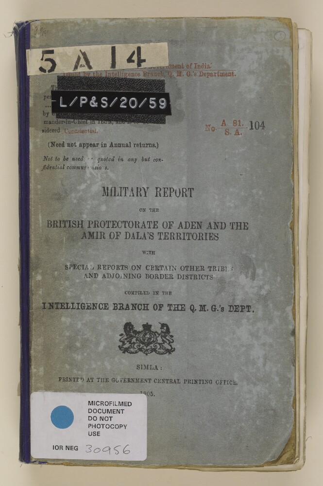
9. ‘Military report on the British Protectorate of Aden and the Amir of Dala’s territories, with special reports on certain other tribes and adjoining border districts’
- Description:
- Abstract: The volume, a military report compiled in the Intelligence Branch of the QMG’s [Quartermaster General’s] Department and published at the Government Central Printing Office, Simla, is comprised of several sections, as follows:section I, a Military Report on the British Protectorate of Aden, prepared by Captain Ernest Arthur Frederick Redl (ff 10-52), and including chapters on: geography; ethnography, with details of the different tribes living in the Protectorate; climate and health; natural resources; harbours and anchorages; communications; fortresses; history; native inhabitants’ administration; the military organisation and strength of native inhabitants; and political relations. A handwritten note is included in the report (f 49), and concerns the entitlements of Protectorate Chiefs to salutes, and issue to them of arms and ammunition, 1906;section II, a Report on the Amir of Dala’s [Ad Dali’] Territories, prepared by Major J K Tod (ff 54-118), and including chapters on: geography; ethnography; climate and health; resources; communications; forts and fortified posts; history; administration, and military. Following the report is a gazetteer providing greater detail of the sixteen districts in Dala, including: topography; ruling families and allegiances; villages and population figures, including numbers of fighting men; water resources; agricultural and industrial activities;section III, Reports on Haushabi, Subehi and Yafa’i Tribes, Turkish and North Western Border Districts and the River Tiban, divided into chapters, all prepared by Captain Redl unless otherwise specified, on: 1) the Haushabi [al-Ḥawshabī] (ff 120-130), and including a handwritten note, dated December 1905 (f 122), noting that the Sultan of Haushabi has agreed to abide by an agreement of 1895; 2) the Subehi tribes near the Turkish border (ff 130-144); 3) the districts of Turkish Yemen adjoining the British boundary (ff 144-165); 4) Tribes of the north-west frontier (ff 165-172); 5) a memorandum of the Yafa’i [Yāfi‘] tribe, prepared by Captain Gonville W Warneford (ff 172-183); 6) The Wadi Tiban (ff 184-185);section IV, Routes(ff 186-228), detailing numerous routes between key points in Aden province, noting: distances; stages; nature of the terrain and its suitability for different modes of transport; available resources en route; territories crossed. A (duplicated) confidential memorandum, written by Captain G A F Sanders of the Aden Brigade, dated 24 August 1905, containing additional information for stages 5 and 6 of route 5 has been added to the volume (ff 195-198);appendix I, a brief statement on inland trade between Aden and the Arabian mainland, 1903 (ff 229-230).The volume is extensively illustrated throughout with fold-out maps, plans and illustrations, prepared by the Intelligence Branch (I.B.) and all of which describe the topography and terrain of the region. There are three maps included in a pocket at the end of the volume: a map of the Aden Protectorate (f 242); a view from the ruined village of Lakmat Magharam about one-and-a-half miles west of Sanah [Ṣanʻā'] (f 240); and a road sketch from Khalla through Awabil [‘Awābil] to the upper plateau of the Rubiatein [Ar Rubay‘atayn] tribe (f 241).Physical description: Foliation: the main foliation sequence (used for referencing) commences at the front cover with 1 and terminates at the back cover with 243; these numbers are written in pencil, are circled, and are located in the top right corner of the recto side of each folio.Pagination: the file contains an original printed pagination sequence.
10. 'Report on the Persian Army compiled in the Intelligence Branch of the Quarter Master General's Department in India by Lieutenant J.A. Douglas 2nd Bengal Lancers'
- Description:
- Abstract: This file is a report on the structure of the Persian Army. Compiled in the Intelligence Branch of the Quarter Master General's Department in India by Lieutenant James Archibald Douglas, the report gives the British perspective of the strength and weaknesses of the Persian Army.The report is broken down into: infantry (organization, strength, method of recruiting, armament); semi-regular cavalry (Cossack brigade, Russian officers); irregular cavalry (General Gordon's opinion); artillery (mule batteries, artillery horses); micellaneous bodies (militia, camel artillery, the Austrian corps); recapitulation of strength distribution (breech-loading rifles, Werndl rifles; Berdan rifles, Chassepot rifles, Gobelin rifles, magazine rifles, and breech-loading ammunition); the army's pay; the army's uniforms; the state of the army; fighting campaigns against the Bakhtiaris, Lurs, and Arab tribes.Included is a slip regarding the custody and disposal of secret documents (f 108).Physical description: Foliation: the foliation sequence for this description (used for referencing) commences at f 106, and terminates at f 116, as it is part of a larger physical volume; these numbers are written in pencil, are circled, and are located in the top right corner of the recto side of each folio.
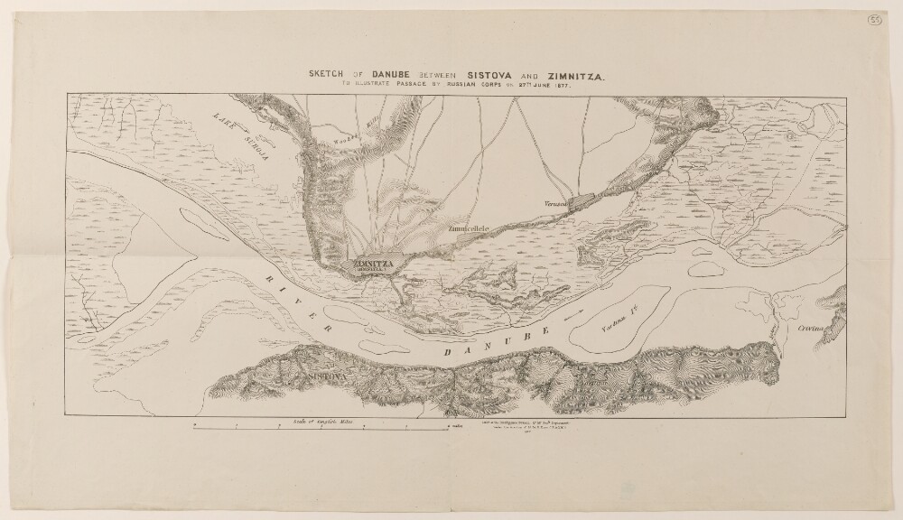
11. ‘Sketch of the Danube between Sistova and Zimnitza. To illustrate the Passage by Russian Corps on 27th June 1877.’
- Description:
- Abstract: Map of the River Danube indicating the passage of Russian troops on 27 June 1877, during the Russo-Turkish War of 1877/78. The map shows: the Danube with tributaries, islands and marshland; topography, with some indication of relief, settlements; roads. Sheet 1 shows the towns of Sistova [Svishtov] and Crivina [Krivina] on the Bulgarian side of the river, and the towns of Zimnitza [Zimnicea], Zimnicellele [Zimnicele] and Verasca [Năsturelu] on the Romanian side. Sheet 2 shows the Romanian towns of Petrosiani [Pietroşani], Petrisni [Pietrişu], Bellaria [Balariile] and Parapanu [Vedea] and Mallu de josu [Malu].A printing statement on sheet 1 states that the map was lithographed at the Intelligence Branch of the Quarter Master General’s Department, under the direction of Lieutenant-Colonel R Home, in 1877.Physical description: Dimensions:Sheet 1: 210 x 510 mm, on sheet 330 x 580 mm. Sheet 2: 330 x 450 mm, on sheet 380 x 560 mm.Materials:Printed on paper.
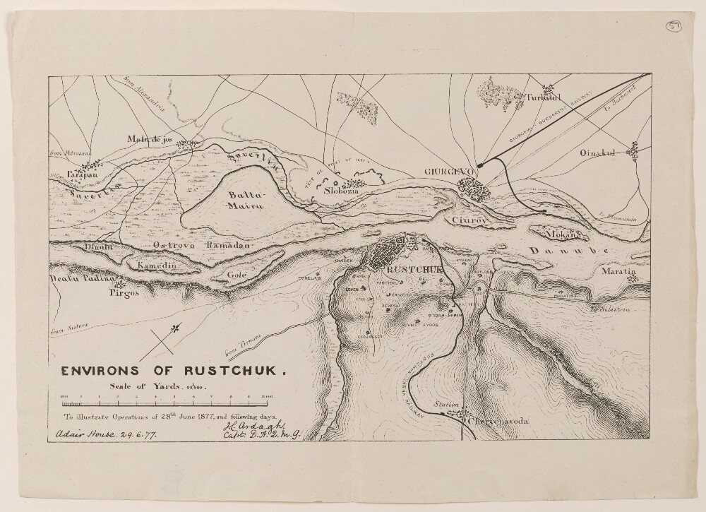
12. ‘Environs of Rustchuk.’
- Description:
- Abstract: Map of Rustchuck [Ruse] and the surrounding region, on the banks of the River Danube. The map indicates: the Danube river, with islands and marshes; topography, with some indication of relief; settlements; fortifications, batteries and cordons; roads and railways.A statement below the title of the map states that it illustrates operations of 28 June 1877 and the days that followed, during which Russian troops advanced into Ottoman territory.The map is signed by Captain H Ardagh, Deputy Assistant Quarter Master General (‘D.A.Q.M.G.’) at Adair House, 29 June 1877.Physical description: Dimensions:185 x 305 mm, on sheet 250 x 345 mm.Materials:Printed on paper.
- « Previous
- Next »
- 1 Current Page, Page 1
- 2