1 - 3 of 3
Number of results to display per page
Search Results
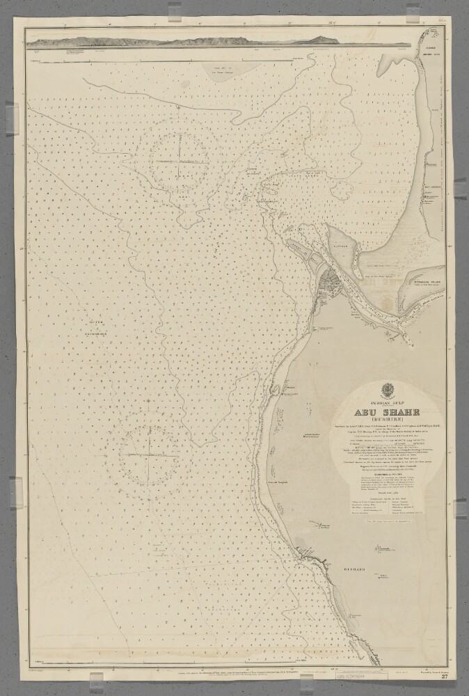
1. 'Abu Shahr (Bushire)'
- Description:
- Abstract: Chart 27.Hydrographic chart covering a twelve-mile length of coast around Abu Shahr, Persia [Bandar-e Bushehr, Iran] on the Persian Gulf. Portrays hydrology, including depths by soundings and contours, sands, mud and rocks, relief by spot heights and rock drawings, vegetation, cultivation, settlements, public buildings, forts and place names, and includes topographical notes and navigational aids, including beacons and prominent buildings.The sheet also portrays, at an unspecified scale, an annotated sketch view (40 x 590mm) of Abu Shahr and adjacent coastline from the west.Chart surveyed by lieutenants Thomas Henry Herbert Hand, Charles Steward Hickman, Edward James Headlam, Alexander Gordon Bingham and William Kirkwood Thyne, Royal Indian Marine under the direction of Captain Thomas Henry Heming, Royal Navy, Marine Survey of India, 1904. Inner anchorage re-sounded by Lieutenant A D D Smyth, Royal Navy, 1911. Engraved by Davies & Company. Published at the Admiralty, 1906, new edition 1912 with small corrections.The number '184.12' is stamped in the top right margin.Physical description: Materials: Printed on paperDimensions: 973 x 637mm, on sheet 664 x 1009mm
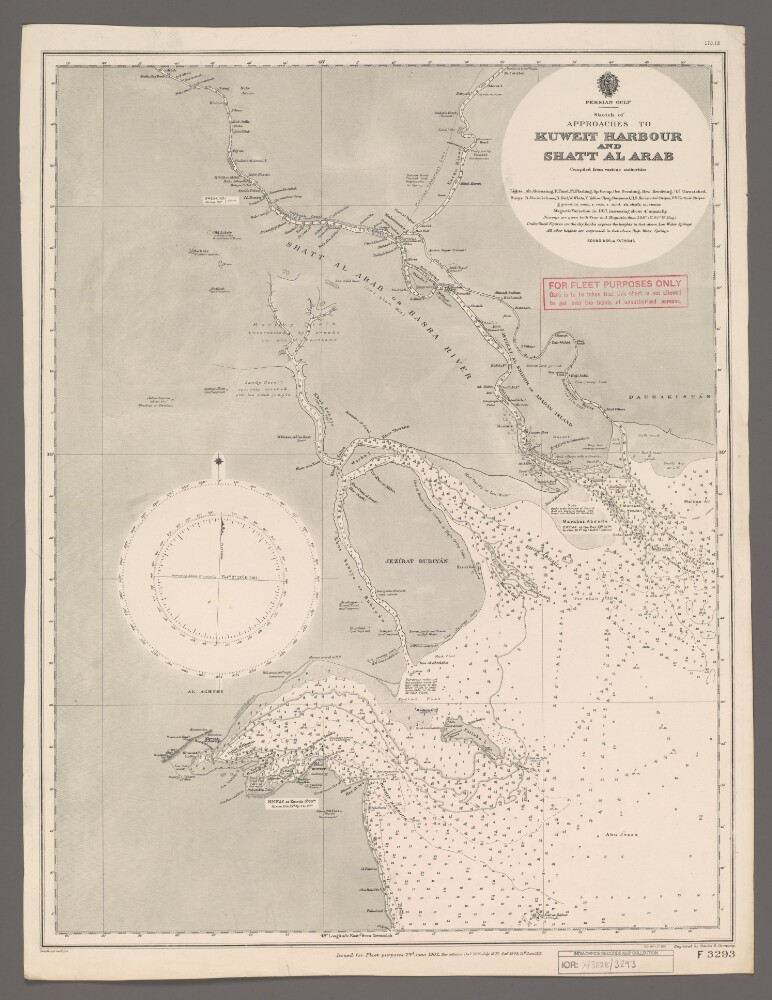
2. 'Sketch of Approaches to Kuweit Harbour and Shatt Al Arab'
- Description:
- Abstract: Chart F3293.Hydrographic chart of the Shatt al Arab in southern Mesopotamia from the vicinity of Al Basra [Al Basrah, Iraq] approximately 100 miles south-eastwards to its mouth at the head of the Persian Gulf. Also includes the approaches to Kuweit [Kuwait] Harbour. Portrays hydrology, including depths by soundings and contours, sands, rocks and mud, relief by spot heights and shading, vegetation, cultivation, canals, settlements including significant buildings, forts and tombs, and place names, and includes topographical notes and navigational aids, including buoys, lights and prominent buildings.Compiled 'from various authorities'. Engraved by Davies & Company. Published by the Admiralty and 'issued for Fleet purposes' 1902, with new editions 1904, 1907, 1909 and 1912, and small corrections.The sheet bears the stamps:'For Fleet Purposes Only. Care is to be taken that this chart is not allowed to get into the hands of unauthorised persons' in red on the map face.The number '170.12' in black in the upper right margin.Physical description: Materials: Printed on paperDimensions: 597 x 456mm, on sheet 660 x 507mm
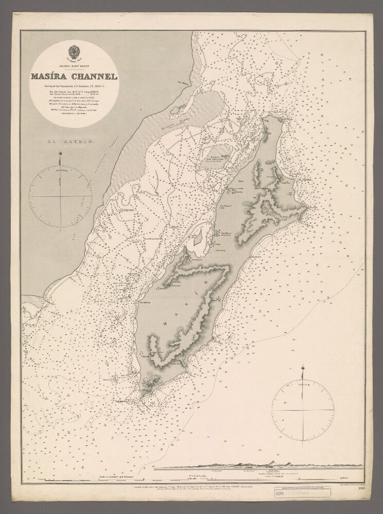
3. 'Masira Channel'
- Description:
- Abstract: Chart 1089.Hydrographic chart covering Masira Channel [Turʻat Masirah], the Arabian Sea, Masira Island [Jazirat Masirah] and a thirty-five-mile length of the eastern Oman coast. The Masira Channel, twelve miles wide and sixty miles long, separates Masira Island from the Omani mainland. Portrays hydrology, including depths by soundings and contours, sands, rocks, anchorages, relief by spot heights and hachures, vegetation, settlements, watering places and place names, and includes topographical notes and navigational aids, including prominent landscape features and buildings.Includes an annotated view, at an unspecified scale, of Masira Island from the south.Chart surveyed by Commander John Parke Sanders, Indian Navy 1845-1846. Engraved by Davies & Company. Published at the Admiralty, 1888.Physical description: Materials: Printed on paperDimensions: 633 x 481mm, on sheet 685 x 508mm