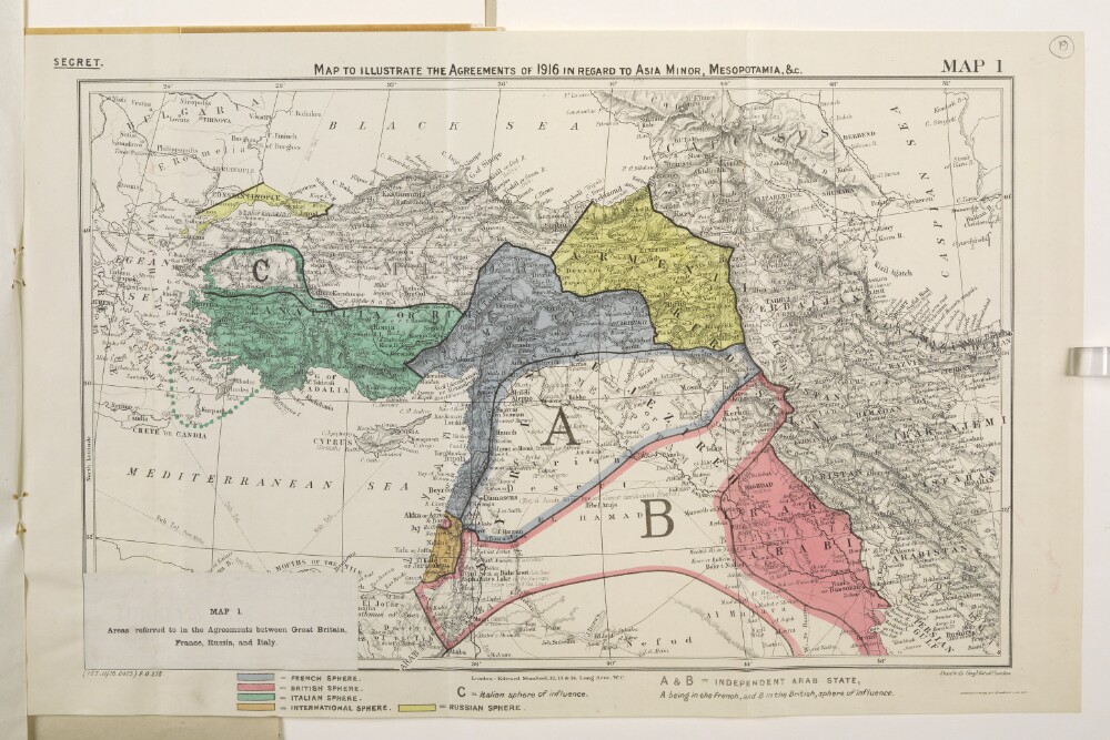
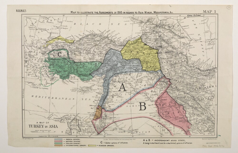
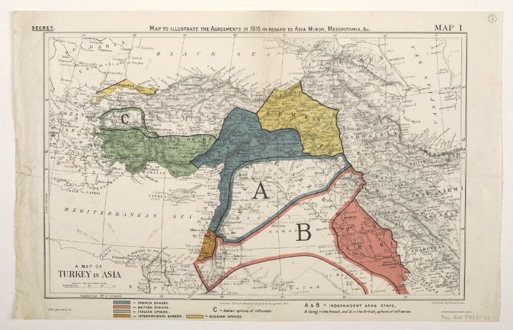
Abstract: Classified 'Secret'.Map forms a part of Mss Eur F112/570, ff 17-23.The original map bears the secondary title 'A Map of Turkey in Asia'. A small paper sheet has been pasted over this and bears a later secondary title 'Map 1. Areas referred to in the Agreements between Great Britain, France, Russia, and Italy.'Map bears the printed designation 'Map 1'. Depicts a proposed division of the Ottoman Empire into spheres of influence and protection by the Allied powers. The division is based on agreements reached between 1916 and 1918. Portrays hydrology, relief by spot heights and hachures, roads and tracks, railways, submarine telegraph lines, settlements, place names and international boundaries. Various blocks of overprinted colour shading correspond to French, British, Italian, Russian and International spheres of influence, including provision for an independent Arab state within the French and British spheres.The base map bears the imprint 'London: Edward Stanford, 12, 13 & 14, Long Acre, W.C.' The printer's imprint 'Harrison & Sons, Lith. St. Martins Lane, W.C.' and print code '(155.11/18.6423) F[oreign].O[ffice].238.' have been added later.Another copy of this map is at Mss Eur F112/570, f 26.Physical description: Materials: Printed in colourDimensions: 243 x 388mm, on sheet 287 x 449mm
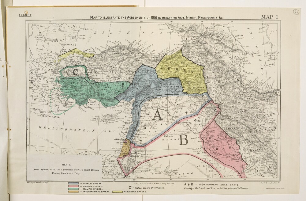
Abstract: Classified 'Secret'.Map forms a part of Mss Eur F112/570, ff 24-30.The original map bears the secondary title 'A Map of Turkey in Asia'. A small paper sheet has been pasted over this and bears a later secondary title 'Map 1. Areas referred to in the Agreements between Great Britain, France, Russia, and Italy.'Map bears the printed designation 'Map 1'. Depicts a proposed division of the Ottoman Empire into spheres of influence and protection by the Allied powers. The division is based on agreements reached between 1916 and 1918. Portrays hydrology, relief by spot heights and hachures, roads and tracks, railways, submarine telegraph lines, settlements, place names and international boundaries. Various blocks of overprinted colour shading correspond to French, British, Italian, Russian and International spheres of influence, including provision for an independent Arab state within the French and British spheres.The base map bears the imprint 'London: Edward Stanford, 12, 13 & 14, Long Acre, W.C.' The printer's imprint 'Harrison & Sons, Lith. St. Martins Lane, W.C.' and print code '(155.11/18.6423) F[oreign].O[ffice].238.' have been added later.Another copy of this map is at Mss Eur F112/570, f 19.Physical description: Materials: Printed in colour on paperDimensions: 243 x 388mm, on sheet 287 x 449mm
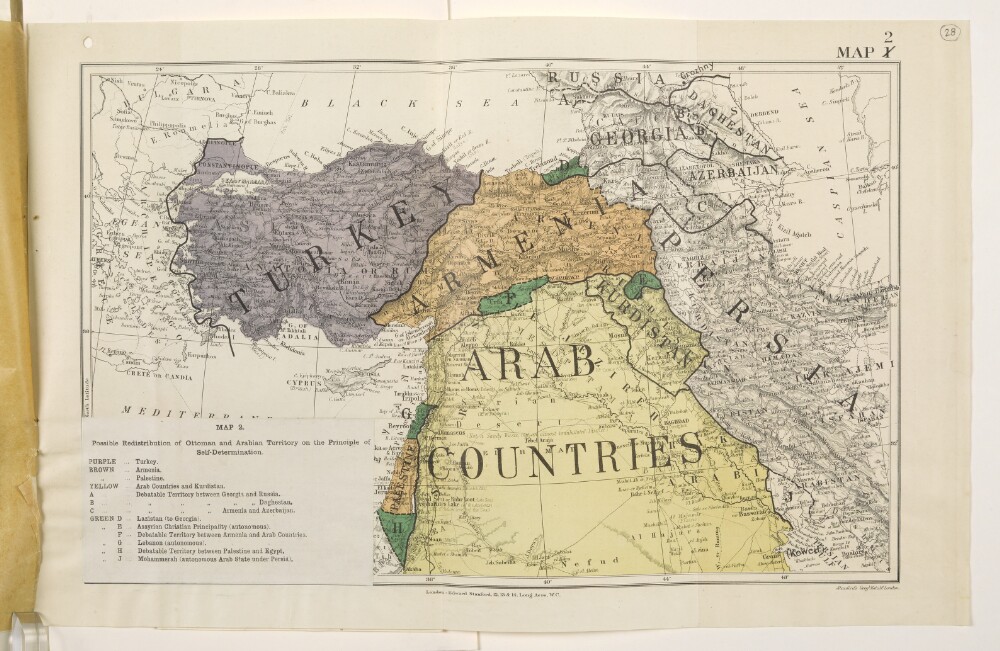
Abstract: Map forms a part of Mss Eur F112/570, ff 24-30.The title and legend are printed on a small paper sheet that has been pasted over the south-west corner of the map. The map number '1' has been deleted and replaced by '2'. Map portrays hydrology, relief by spot heights and hachures, roads and tracks, railways, submarine telegraph lines, settlements, place names and international boundaries. Map also depicts, by variously coloured shading, areas in which self-determination is deemed possible. Bears the imprint 'London: Edward Stanford, 12, 13 & 14, Long Acre, W.C.' [Published by the Political Intelligence Department, Foreign Office, 21 November 1918].An overlay to this sheet is at Mss Eur F112/570, f 27.Another copy of this map is at Mss Eur F112/570, f 21.Physical description: Materials: Printed in colourDimensions: 243 x 388mm, on sheet 290 x 452mm
Abstract: Map forms a part of Mss Eur F112/570, ff 17-23.The title and legend are printed on a small paper sheet that has been pasted over the south-west corner of the map. The map number '1' has been deleted and replaced by '2'. Map portrays hydrology, relief by spot heights and hachures, roads and tracks, railways, submarine telegraph lines, settlements, place names and international boundaries. Map also depicts, by variously coloured shading, areas in which self-determination is deemed possible. Bears the imprint 'London: Edward Stanford, 12, 13 & 14, Long Acre, W.C.' [Published by the Political Intelligence Department, Foreign Office, 21 November 1918].An overlay to this sheet is at Mss Eur F112/570, f 20.Another copy of this map is at Mss Eur F112/570, f 28.Physical description: Materials: Printed in colourDimensions: 243 x 388mm, on sheet 290 x 452mm
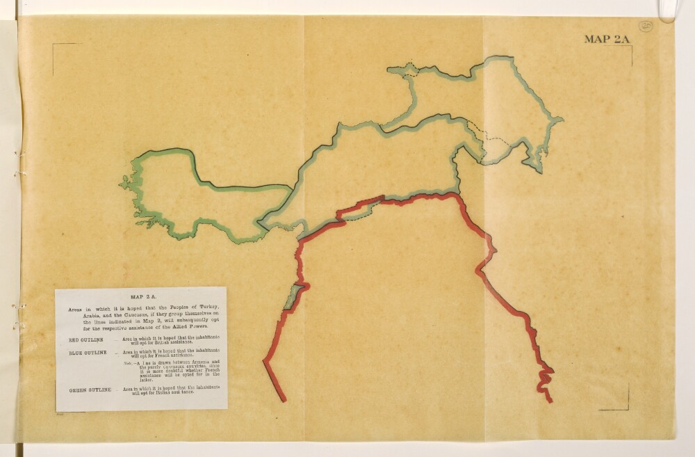
Abstract: Map is an overlay to Mss Eur F112/570, f 21 and forms a part of Mss Eur F112/570, ff 17-23.The title and legend are printed on a small paper sheet that has been pasted over the south-west corner of the map. Map portrays, by variously coloured boundaries, areas in which it is 'hoped that the inhabitants will opt for [British, French or Italian] assistance'. Bears the imprint '8146.' [Published by the Political Intelligence Department, Foreign Office, 21 November 1918.]Another copy of this map is at Mss Eur F112/570, f 27.Physical description: Materials: Printed in colour on tracing paperDimensions: 243 x 393mm, on sheet 290 x 450mm
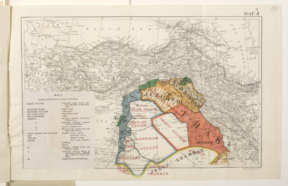
Abstract: Map forms a part of Mss Eur F112/570, ff 17-23.The title and legend are printed on a small paper sheet that has been pasted over the south-west corner of the map. The map number '1' has been deleted and replaced by '3'. Map portrays hydrology, relief by spot heights and hachures, roads and tracks, railways, submarine telegraph lines, settlements, place names and international boundaries. Map also depicts, by variously coloured shading and lettering, possible settlement arrangements of Arab countries, incorporating a range of ethnological categories. Bears the imprint 'London: Edward Stanford, 12, 13 & 14, Long Acre, W.C.' [Published by the Political Intelligence Department, Foreign Office, 21 November 1918.]Another copy of this map is at Mss Eur F112/570, f 29.Physical description: Materials: Printed in colourDimensions: 258 x 388mm, on sheet 288 x 450mm
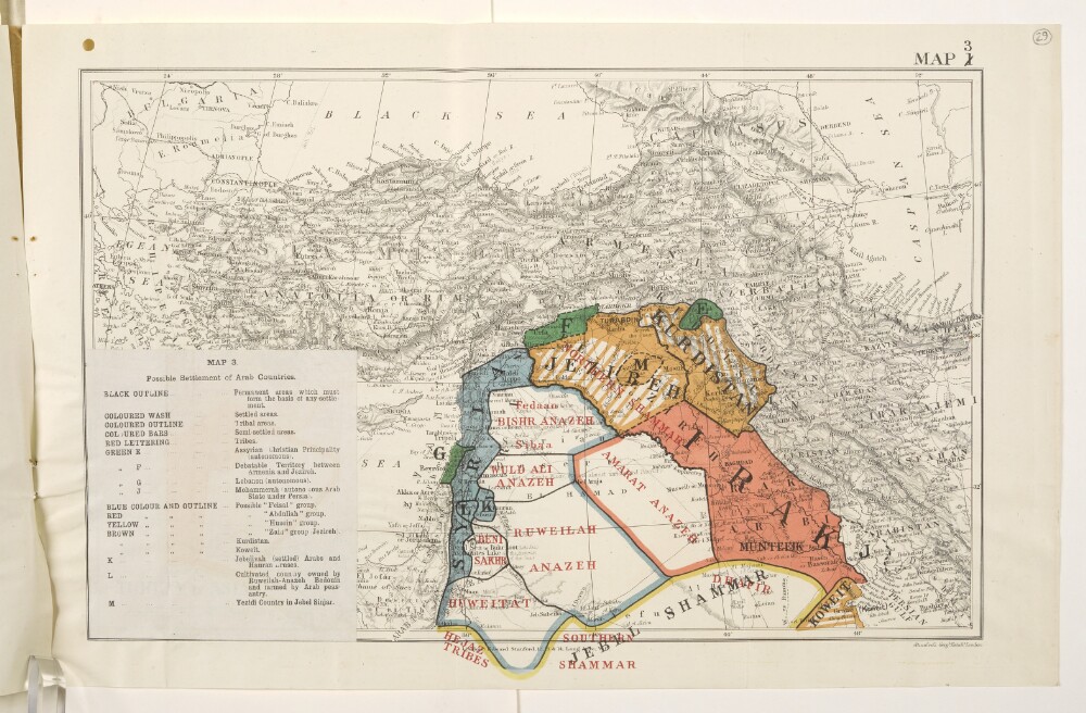
Abstract: Map forms a part of Mss Eur F112/570, ff 24-30.The title and legend are printed on a small paper sheet that has been pasted over the south-west corner of the map. The map number '1' has been deleted and replaced by '3'. Map portrays hydrology, relief by spot heights and hachures, roads and tracks, railways, submarine telegraph lines, settlements, place names and international boundaries. Map also depicts, by variously coloured shading and lettering, possible settlement arrangements of Arab countries, incorporating a range of ethnological categories. Bears the imprint 'London: Edward Stanford, 12, 13 & 14, Long Acre, W.C.' [Published by the Political Intelligence Department, Foreign Office, 21 November 1918.]Another copy of this map is at Mss Eur F112/570, f 22.Physical description: Materials: Printed in colourDimensions: 258 x 388mm, on sheet 288 x 450mm
Abstract: Classified 'Secret'.The map bears a secondary title 'A Map of Turkey in Asia'.Bears the printed designation 'Map 1'. Depicts a proposed division of the Ottoman Empire into spheres of influence and protection by the Allied powers. The division is based on agreements reached between 1916 and the end of the First World War. Portrays hydrology, relief by spot heights and hachures, roads and tracks, railways, submarine telegraph lines, settlements, place names and international boundaries. A black overprint combined with watercolour washes show French, British, Italian, Russian and International spheres of influence, including provision for an independent Arab state within the French and British spheres. Some place names have been highlighted in manuscript.The base map bears the imprint 'London: Edward Stanford, 12, 13 & 14, Long Acre, W.C.' The printer's imprint 'Harrison & Sons, Lith. St. Martins Lane, W.C.' and print code '(40.10/18.6360)F[oreign].O[ffice].238.' have been added later.Verso bears an undetermined annotation.Physical description: Materials: Printed in colour, with additions in watercolour, ink and crayonDimensions: 243 x 388mm, on sheet 286 x 449mm
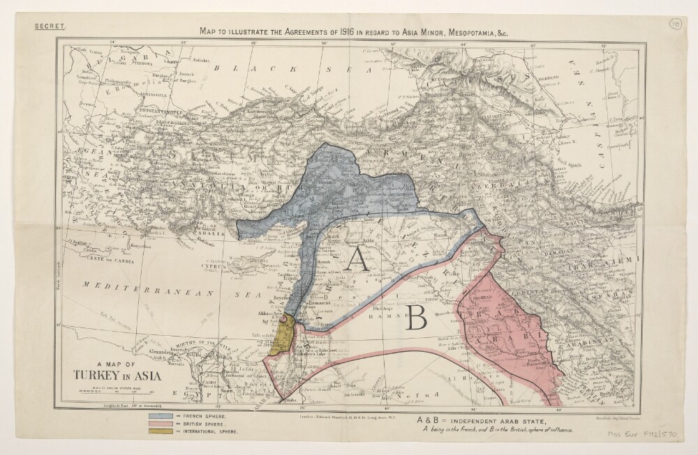
Abstract: Classified 'Secret'.The map bears a secondary title 'A Map of Turkey in Asia'.Depicts a proposed division of the Ottoman Empire into spheres of influence and protection by the Allied powers. The division is based on agreements reached between 1916 and the end of the First World War. Portrays hydrology, relief by spot heights and hachures, roads and tracks, railways, submarine telegraph lines, settlements, place names and international boundaries. A black overprint combined with watercolour washes show French, British and International spheres of influence, including provision for an independent Arab state within the French and British spheres.The base map bears the imprint 'London: Edward Stanford, 12, 13 & 14, Long Acre, W.C.'Verso bears the annotation '2nn' [?] and the stamp 'Eastern Department'.Physical description: Materials: Printed in colour, with additions in watercolour, pencil and rubber stampDimensions: 243 x 388mm, on sheet 284 x 447mm
Abstract: Three identical map sheets.Classified 'Secret'.The map bears a secondary title 'A Map of Turkey in Asia'.Bears the printed designation 'Map 1'. Depicts a proposed division of the Ottoman Empire into spheres of influence and protection by the Allied powers. The division is based on agreements reached between 1916 and 1919. Portrays hydrology, relief by spot heights and hachures, roads and tracks, railways, submarine telegraph lines, settlements, place names and international boundaries. Various blocks of overprinted colour shading correspond to French, British, Italian, Russian and International spheres of influence, including provision for an independent Arab state within the French and British spheres.The base map bears the imprint 'London: Edward Stanford, 12, 13 & 14, Long Acre, W.C.' The printer's imprint 'Harrison & Sons, Lith. St. Martins Lane, W.C.' and print code '(350.1/19.6648) F[oreign].O[ffice].' have been added later.Folio 14 has manuscript boundary additions in pencil and crayon.Physical description: Materials: Printed in colour, with manuscript additions in pencil and crayonDimensions: 243 x 388mm, on sheet 289 x 452mm
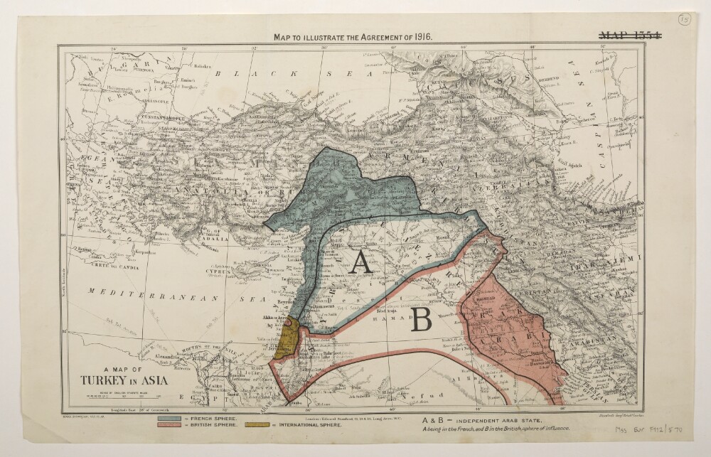
Abstract: Two identical map sheets.The map bears a secondary title 'A Map of Turkey in Asia'.Bears the deleted designation 'Map 1354'. Depicts a proposed division of the Ottoman Empire into spheres of influence and protection by the Allied powers. The division is based on agreements reached between 1916 and 1919. Portrays hydrology, relief by spot heights and hachures, roads and tracks, railways, submarine telegraph lines, settlements, place names and international boundaries. Various blocks of overprinted colour shading correspond to French, British and International spheres of influence, including provision for an independent Arab state within the French and British spheres.The base map bears the imprint 'London: Edward Stanford, 12, 13 & 14, Long Acre, W.C.' The print code '8995.21848./131.135.10.19.' has been added later.The verso of folio 15 bears the annotation 'SP'.Physical description: Materials: Printed in colourDimensions: 243 x 388mm, on sheet 289 x 452mm