1 - 2 of 2
Number of results to display per page
Search Results
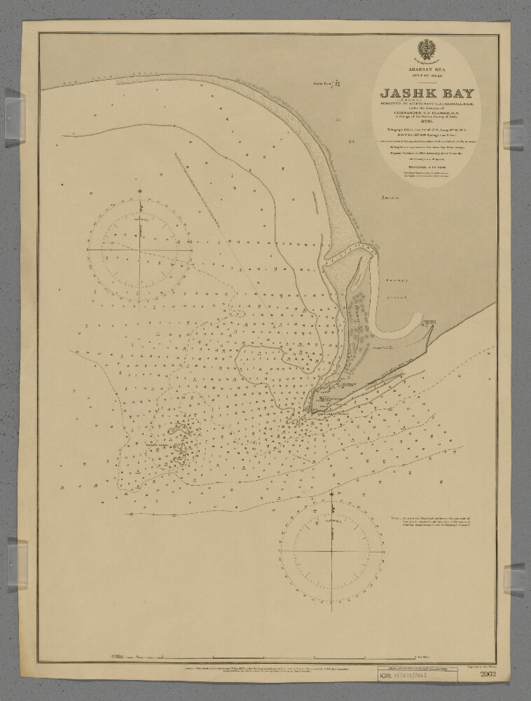
1. 'Jashk (Jashak) Bay'
- Description:
- Abstract: Chart 2862.Hydrographic chart covering the eastern half of Jashk Bay [Khalij-e Jask], Cape Jashk [Damagheh-ye Jashk] and Mason Shoal, Persia [Iran] in the Gulf of Oman. Portrays hydrology, including depths by soundings and contours, sands and rocks, anchorages, relief by spot heights, hachures and shading, vegetation, cultivation, settlements, public buildings, telegraph offices, forts and place names, and includes topographical notes and navigational aids, including beacons, and prominent landmarks.Surveyed by Lieutenant Charles James Cope Kendall, Royal Indian Marine, 1896. Engraved by Edward Weller. Published at the Admiralty, 1897.Physical description: Materials: Printed on paperDimensions: 628 x 457mm, on sheet 658 x 494mm
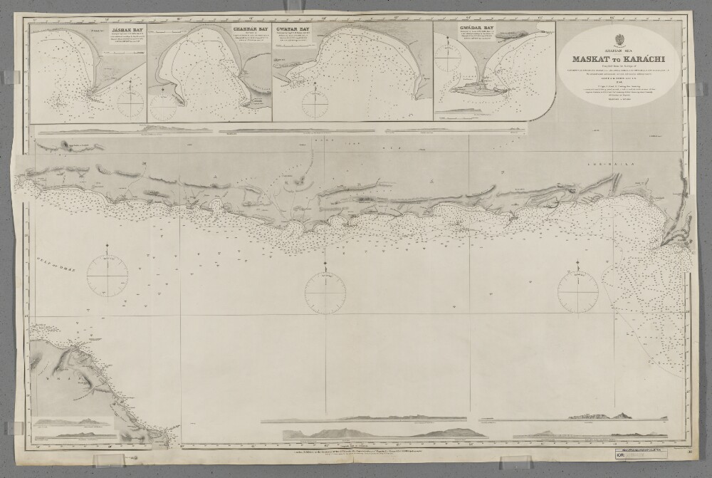
2. 'Maskat to Karachi'
- Description:
- Abstract: Chart 38.Hydrographic chart covering a 570-mile route through the Gulf of Oman and Arabian Sea from Maskat [Masqat], Oman, east-north-eastwards to Karachi, British India [Pakistan]. The sheet also depicts a 170-mile length of Omani coast in the vicinity of Maskat and a 630-mile length of coast between Cape Jashak, Persia [Damagheh-ye Jask, Iran] eastwards to Karachi.Portrays hydrology, including depths by soundings and contours, sands, mud, rocks and anchorages, relief by spot heights and hachures, vegetation, settlements, public buildings, telegraph offices and place names, and includes topographical notes and navigational aids, including buoys, lights and prominent buildings.Includes insets of Jashak Bay [Khalij-e Jask], Persia, at scale 1:121,000; Chahbar Bay [Khalij-e Chah Bahar], Persia, at scale 1:96,800; Gwatar Bay [Dahaneh-ye Gowatar], Persia and British India, at scale 1:96,800; and Gwadar Bay, [Gwadar Bay (West and East), British India, at scale 1:96,800.Ten annotated sketches of significant navigational views, at unspecified scales, on both the north and south coasts of the Gulf of Oman and Arabian Sea are also included.Chart compiled from the surveys of captains George Barnes Brucks, Stafford Bettesworth Haines, Thomas Grere Carless, Albany Moore Grieve, Charles Golding Constable, Arthur Whatley Chitty and Arthur William Stiffe, all late Indian Navy. Engraved by Edward Weller. Published at the Admiralty, 1874.Physical description: Materials: Printed on paperDimensions: 668 x 1043mm, on sheet 688 x 1049mm