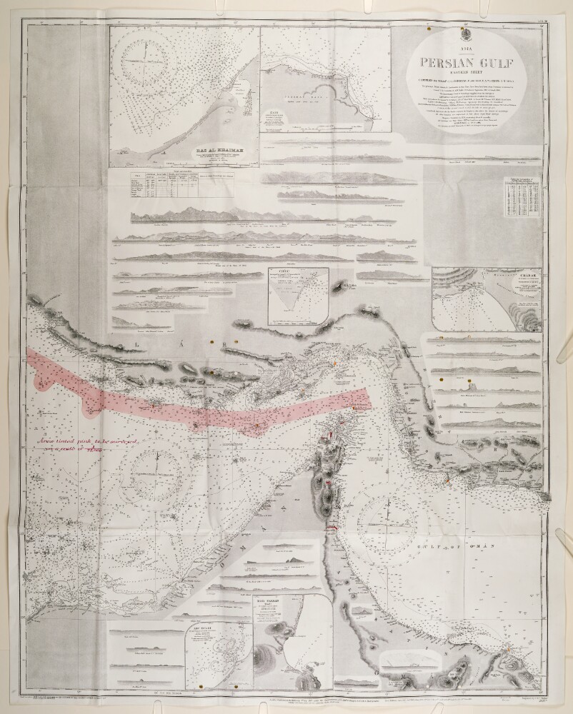
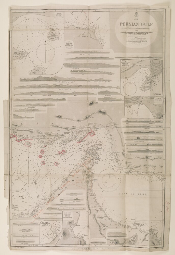
Abstract: A map of the Eastern Persian Gulf that was compiled by Commander C G Constable and Lieutenant A W Stiffe in 1860. Corrections made by Commander F H Walter, HMS
Odinand Lieutenant H T Bowen, HMS
Alertin 1910. This version was printed by the Admiralty in 1929. Engraved by J & C Walker.The map has major settlements and relief marked, with water depth shown by soundings. An area of a proposed Royal Navy survey is marked in pink on the map.The map has detailed inserts showing the shore lines of Charak, Kais, Ras al-Khaimah, Hor [Khor] Fakkan, Abu Dhabi and Chiru.Physical description: Materials: Printed on paperDimensions: 1,100mm x 820mm
Abstract: The Portugues Asia: or, The history of the discovery and conquest of India by the Portugues; containing all their discoveries from the coast of Africk, to the farthest parts of China and Japan; all their battels by sea and land, sieges and other memorable actions; a description of those countries, and many particulars of the religion, government and customs of the natives, &c. In three tomes. Written in Spanish by Manuel de Faria y Sousa, of the Order of Christ. Translated into English by Cap. John Stevens. Tome the First.Publication Details: London, Printed for C. Brome, at the Sign the Gun, at the West-End of St. Pauls, 1694.Physical Description: Octavo.Physical description: Dimensions: 185mm x 105mm
Abstract: The Portugues Asia: or, The history of the discovery and conquest of India by the Portugues; containing all their discoveries from the coast of Africk, to the farthest parts of China and Japan; all their battels by sea and land, sieges and other memorable actions; a description of those countries, and many particulars of the religion, government and customs of the natives, &c. In three tomes. Written in Spanish by Manuel de Faria y Sousa, of the Order of Christ. Translated into English by Cap. John Stevens. Tome the Third.Publication Details: London, Printed for C. Brome, at the Sign the Gun, at the West-End of St. Pauls, 1694.Physical Description: Octavo.Physical description: Dimensions: 185mm x 105mm
Abstract: The Portugues Asia: or, The history of the discovery and conquest of India by the Portugues; containing all their discoveries from the coast of Africk, to the farthest parts of China and Japan; all their battels by sea and land, sieges and other memorable actions; a description of those countries, and many particulars of the religion, government and customs of the natives, &c. In three tomes. Written in Spanish by Manuel de Faria y Sousa, of the Order of Christ. Translated into English by Cap. John Stevens. Tome the Second.Publication Details: London, Printed for C. Brome, at the Sign the Gun, at the West-End of St. Pauls, 1694.Physical Description: Octavo.Physical description: Dimensions: 185mm x 105mm
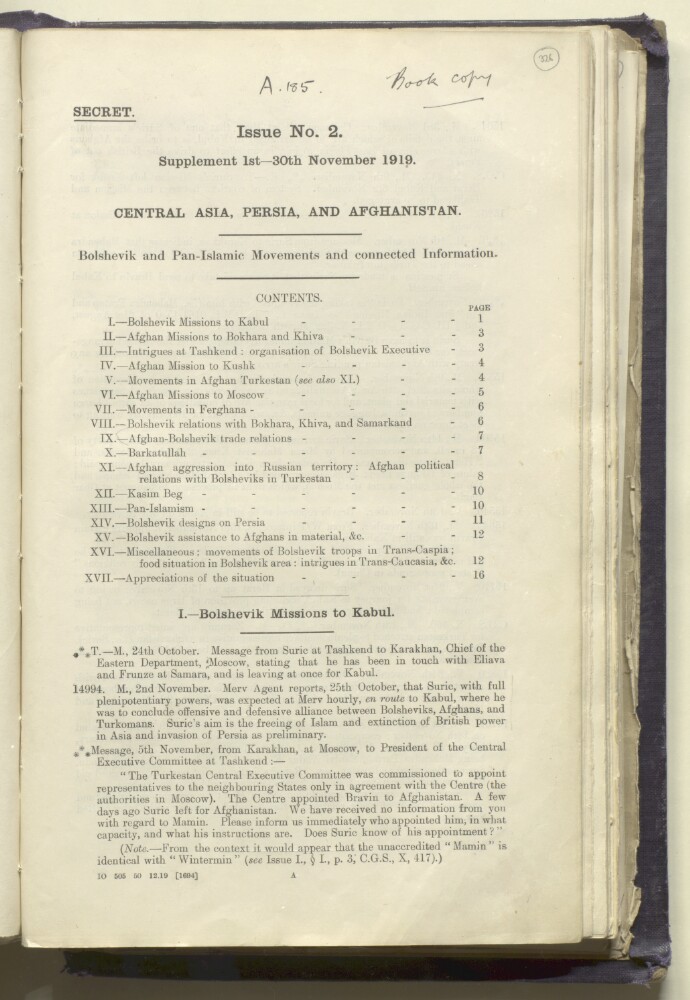
Abstract: The file consists primarily of summaries of letters, memoranda, and reports dated between 1 and 30 November 1919; the subject matter concerns Bolshevik and Pan-Islamic movements in Central Asia, Persia, and Afghanistan.The following titles are abbreviated in the file as indicated: Chief of the [Imperial] General Staff (CGS); Foreign Secretary (FS) — most likely — to the Government of India; and Viceroy of India (V).Physical description: Foliation: the foliation sequence for this description commences at f 326 and terminates at f 333, as it is part of a larger physical volume; these numbers are written in pencil, are circled, and are located in the top right corner of the recto side of each folio.
Abstract: Central Asia. Part V. A contribution towards the better knowledge of the History, Ethnography, Topography, and resources of part of Asiatic Turkey and Caucasia.The book is written by Charles Metcalfe MacGregor.Publication Details: Calcutta: Foreign Department Press. 1872.Physical description: Dimensions: 250 mm x 155 mm.Pagination: 1-342.
Abstract: This file contains summaries of reports, letters and memoranda concerning Bolshevik and Pan-Islamic movements in Central Asia, Persia and Afghanistan. The file is divided into a series of sections, each of which contains summaries of reports, letters and memoranda. Prominent correspondents include the Chief of the General Staff (officially known as the Chief of the Imperial General Staff during this period but referred to here as 'CGS'), the Directorate of Military Intelligence ('DMI'), the Secretary of State for India ('S'), the Foreign Secretary (abbreviated simply as 'FS'; given the department in which this file was produced it is most likely that 'FS' refers to the Foreign Secretary of the Government of India), and the Viceroy and Governor-General of India ('V').The contents are listed as follows (the date ranges of each section are provided in brackets):I. Bolshevik Missions to Kabul (12 May-3 November 1919);II. Afghan Missions to Bokhura [Bukhara] and Khiva (8 June-3 November 1919);III. Intrigues at and with Tashkend (3 May-26 October 1919);IV. Afghan Mission to Kushk (3 June-14 October 1919);V. Movements in Afghan Turkestan (3 June-14 October 1919);VI. Afghan Missions to Moscow (28 May-2 November 1919);VII. Movements in Ferghana (2 May-20 October 1919);VIII. Bolshevik relations with Bokhara, Samarkand, and Khiva (12 June-29 October 1919);IX. Bolshevik-Afghan trade (27 July-12 October 1919);X. Barkatullah (18 July-13 October 1919);XI. Afghan aggression into Russian territory (2-31 October 1919);XII. Kasim Beg (24 July-19 October 1919);XIII. Pan-Islamism (30 May-30 October 1919);XIV. Bolshevik designs on Persia (24 July-31 October 1919);XV. Bolshevik Promises of Assistance to Afghans (16 June-2 October 1919);XVI. Miscellaneous (21 July-31 October 1919);XVII. Government of India's appreciations of position, etc. (23 June-10 September 1919).Physical description: Foliation: the foliation sequence commences at the first folio and terminates at the last folio; these numbers are written in pencil, are circled, and are located in the top right corner of the recto side of each folio.Pagination: the file also contains an original printed pagination sequence.
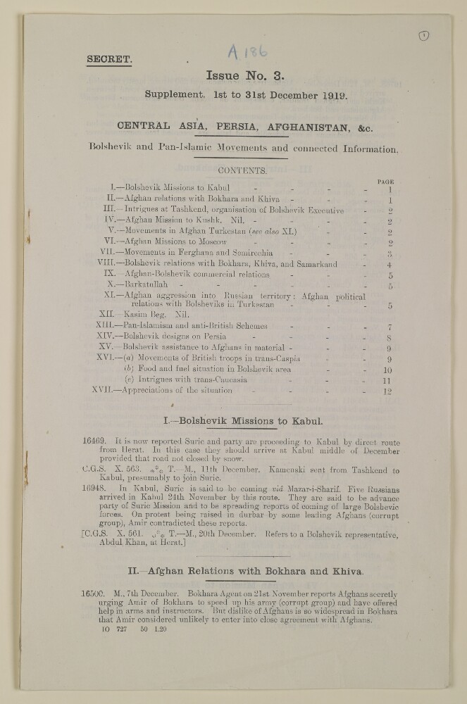
Abstract: The file consists primarily of summaries of letters, memoranda, and reports dated between 26 November 1919 and 5 January 1920; the subject matter concerns Bolshevik and Pan-Islamic movements in Central Asia, Persia, and Afghanistan. These summaries are divided into a series of sections which are as follows:I. Bolshevik Missions to Kabul;II. Afghan Relations with Bokhara and Khiva;III. Intrigues at Tashkend;IV. Afghan Mission to Kushk;V. Movements in Afghan Turkestan;VI. Afghan Mission to Moscow;VII. Movements in Ferghana and Semirechia;VIII. Bolshevik relations with Bokhara, Khiva and Samarkand;IX. Afghan-Bolshevik Commercial Relations;X. Barkatullah;XI. Afghan Aggression into Russian Territory: Afghan political Relations with Bolsheviks in Turkestan;XII. Kasim Beg;XIII. Pan-Islamism and anti-British Schemes;XIV. Bolshevik Designs on Persia;XV. Bolshevik assistance to Afghans in Material, &c.;XVI. Miscellaneous: (a) Movements of Bolshevik troops in Transcaspia. (b) Food and fuel situation in Bolshevik area. (c) Intrigues with Trans-Caucasia;XVII. Appreciations of the General Situation.Section XVII contains substantial extracts from letters, memoranda, and reports rather than the usual summaries. Sections IV and XII are empty; nil is used to indicate that there are no reports in these sections for the period in question.The following titles are abbreviated in the file as indicated: Chief of the [Imperial] General Staff (CGS); Director of Military Intelligence (DMI); and Foreign Secretary (FS) — most likely — to the Government of India.Physical description: Foliation: the foliation sequence commences at the first folio and terminates at the last folio; these numbers are written in pencil, are circled, and are located in the top right corner of the recto side of each folio.Pagination: the file also contains an original printed pagination sequence.
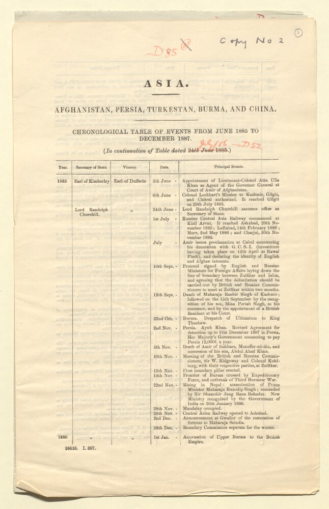
Abstract: The first part of the file (folios 1 to 2) consists of a chronological table of 'principal events' which took place in Afghanistan, Burma, China, Turkestan, and Persia between June 1885 and December 1887. Each entry includes a brief description and the date. In addition, it also indicates who was the Secretary of State for India and who was the Viceroy of India during the event in question. This list is dated 1 January 1888.The second part of the file (folios 3 to 5) consists of a copy of letter from Sir Arthur Hirtzel to Mr Parker dated 26 February 1913. It concerns a compromise that might be reached with the Ottoman Empire over the status of Koweit [Kuwait]. It also includes copies of the following enclosures:1. a proposed statement defining the territorial limits to which the British will guarantee the autonomy of the Sheikh of Koweit;2. extract of a letter from Major Stuart George Knox, Political Agent, Kuwait, dated 23 May 1908. It concerns the suzerainty of Anta'a;3. extracts from Major Knox's report on his trip to Anta'a, which claims that the local population views the Sheikh of Koweit as their legitimate ruler;4. extract of a letter from Captain William Henry Irvine Shakespear, Political Agent, Koweit, dated 23 March 1910. It conveys some of his opinions concerning the territorial extent of Koweit;5. extract from Captain Shakespear's diary dated 25 February 1910.Also included in the second part is a map (folio 4) showing the limits of Koweit and adjacent territory, which includes south eastern Iraq, south western Persia, and a significant part of the Persian Gulf.Physical description: Foliation: the foliation sequence commences at the first folio and terminates at the last folio; these numbers are written in pencil, are circled, and are located in the top right corner of the recto side of each folio.Pagination: the file consists of two parts and each has an original printed pagination sequence.
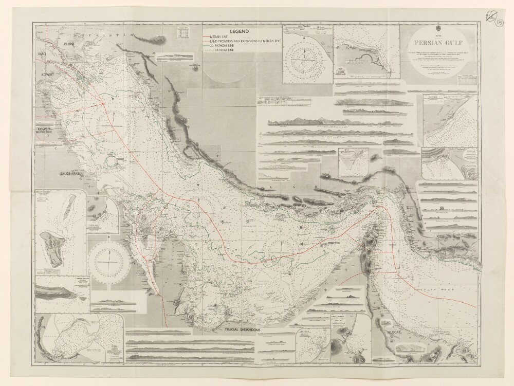
Abstract: Hydrographic Office map showing the Persian Gulf and Gulf of Oman, with a number of inset maps (including Doha and Abu Dhabi), and views of the coast and islands from the sea. Compiled from surveys by Captain John Michael Guy and Captain George Barnes Brucks, 1821-29, and by Commander Charles Golding Constable and Lieutenant ArthurWilliam Stiffe, 1860, with additions and corrections from surveys by Commander Henry Boyle Townshend Somerville 1903, Commander FH Walter, 1910, Lieutenant HT Bowen, 1910, and Commander Arthur Guy Norris Wyatt, Lieutenant-Commander DH Fryer and Commander A Day, HM Surveying ship
Ormonde, 1930-33.Soundings given in fathoms. Settlements marked, and some indication of relief.Map shows median line (in red); land frontiers and extensions to median line (red dotted line); 20 fathom line (in green); and 10 fathom line (green dotted line). This information is given in a legend at the top centre of the map.No scale given for main map; scale of insets varies.Physical description: Materials: printed on paper.Dimensions: 490 x 640mm, on sheet 520 x 700mm.
Abstract: A map indicating the location of one buoy in the vicinity of Kishm in the Persian Gulf. The buoy is marked in manuscript on an inset map entitled 'Kishm and Parts Adjacent', with corresponding arrows drawn in the upper and left margins.The base map on which the buoy is indicated is Admiralty chart 2837a, 'Published at the Admiralty 1st. May 1862', 'Small corrections... III-1907'.A hand stamp on the verso reads, 'British India Steam Navigation Co. Ltd. Received 19 Aug. 1908'.Physical description: Materials: Printed on paper with manuscript additions in coloured inkDimensions: 975 x 637mm, on sheet 1023 x 680mm
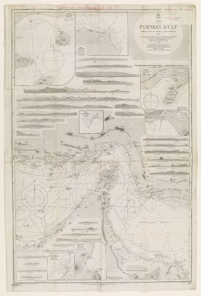
Abstract: Admiralty Hydrographic Office chart showing the principal points, islands, and landmarks of the (eastern) Persian Gulf and Gulf of Oman, compiled by Commander C G Constable and Lieutenant Arthur William Stiffe between September 1857 and March 1860, with intervening coast and soundings supplied from the surveys of Captain J M Guy and Captain George Barnes Brucks in 1821-29. Published at the Admiralty in 1862, with small and large corrections to 1899. Engraved by J and C Walker. Inset: Kishm [Qeshm], Kais [Kish], Henjam [Hengām], Charak [Bandar-e Chārak], Abu Thabi [Abu Dhabi], and Khor Fakan [Khawr Fakkān].No scale given for the main map. The scale of the insets varies.Annotated in red crayon to show territory of Trucial Chiefs [Trucial Coast].Inscribed on recto: 'Pol. 716/1900'.Inscribed on verso: 'D42'.Physical description: Materials: printed on paper.Dimensions: 970 x 630mm, on sheet 100 x 660mm.