Abstract: A copy of an anonymous letter in French forwarding reports from Afghanistan, copied by Harford Jones and dated Bagdad [Baghdad], 18 December 1801.The letter reports widespread alienation from Chah Mahmood [Mahmūd Shāh Durrānī], divisions amongst Chah Mahmood’s troops in Kaboul [Kabul], and large-scale desertions to the side of Shugia ul Mulk [Shujā’ al-Mulk Durrānī]. The author expects Chah Mahmood to abandon Kaboul before the autumn and take refuge in Candahar [Kandahar].Physical description: 1 item (2 folios)
Abstract: An anonymous French account of the 1773 plague outbreak in Bassora [Basra].The author describes: his confinement in the French Factory in Bassora; the illness and death of Claude Pyraut [Pirault], French Consul in Bassora, and other employees of the Factory; his own illness and recovery; the long-term side effects of his infection; and his recommendations for others who become infected.The account was copied by Harford Jones, Resident in Bagdad [Baghdad], and may have been found in the papers of Jean-François Rousseau, French Consul in Bagdad, following his arrest in October 1798.Physical description: 1 item (10 folios)
Abstract: A report written in French and dated Bagdad [Baghdad], 23 April 1802, relaying information received from a messenger from Tahran [Tehran] concerning the Kingdom of the Agvans [Afghanistan].The report describes a siege of Herat led by Chah Zadé Kaisser [Shāhzādeh Qaiṣar] and rumours of attacks on Candahar [Kandahar] and Cabul [Kabul] by the Ghelgies [Ghilzaī tribe]. The author also speculates on the activities of Chugia al Mulk [Shujā’ al-Mulk Durrānī] and Fataly Chah [Fatḥ-‘Alī Shāh Qājār, Shāh of Persia] and the future of the country.Physical description: 1 item (2 folios)
Abstract: A report from Herat by an anonymous French author in the service of Shah Zeman [Zamān Shāh Durrānī, Ruler of Afghanistan], dated 3 September 1799.The report describes the campaign of Baba Khan [Fatḥ-‘Alī Shāh Qājār, Shāh of Persia] in eastern Persia [Iran], including the capture of Nichabour [Nishabur] and the siege of Mashate [Mashhad], and Baba Khan’s retreat when faced with large forces led by Shah Zeman and Shah Mourad [Shāhmurād, Amīr of Bukhara]. The report states that many Persian troops were captured by tribes to be sold into slavery in Boukara [Bukhara] and that Shah Zeman is now planning an expedition to Lahor [Lahore].Physical description: 1 item (2 folios)
müellifleri Hānrī Būnfīs, Pūl Fūshīl ; mütercimi Ahmet Salahattin.Translation of: Manuel de droit international public.Vol. 2 translated by Mehmet Cemil.In Ottoman Turkish.
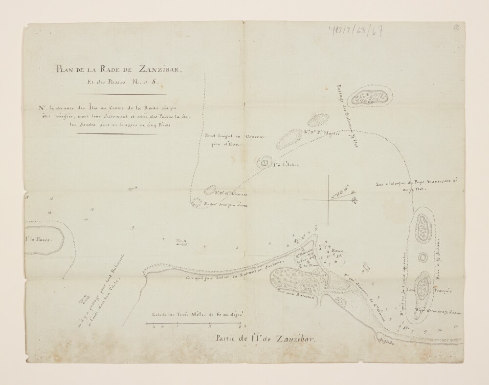
Abstract: Manuscript map used to illustrate routes of navigation around the harbour of Zanzibar [Zanzibar City] and the surrounding islands. The map indicates the coastline and coastal waters to a distance of two miles offshore, and portrays coastal and inland hydrography, vegetation, hachuring on coastal slopes, details of the fort and adjacent buildings of Zanzibar, and sandbanks, and includes topographical and navigational notes, depths by soundings, and coastal flows.The map was enclosed in HM Envoy Extraordinary and Minister Plenipotentiary to Persia [Iran], Sir Harford Jones’s Dispatch No. 25 of 14 September 1810, which was received on 6 February 1811.Physical description: Manuscript: ink on paperDimensions: 400 x 275mm, on sheet 400 x 311mm
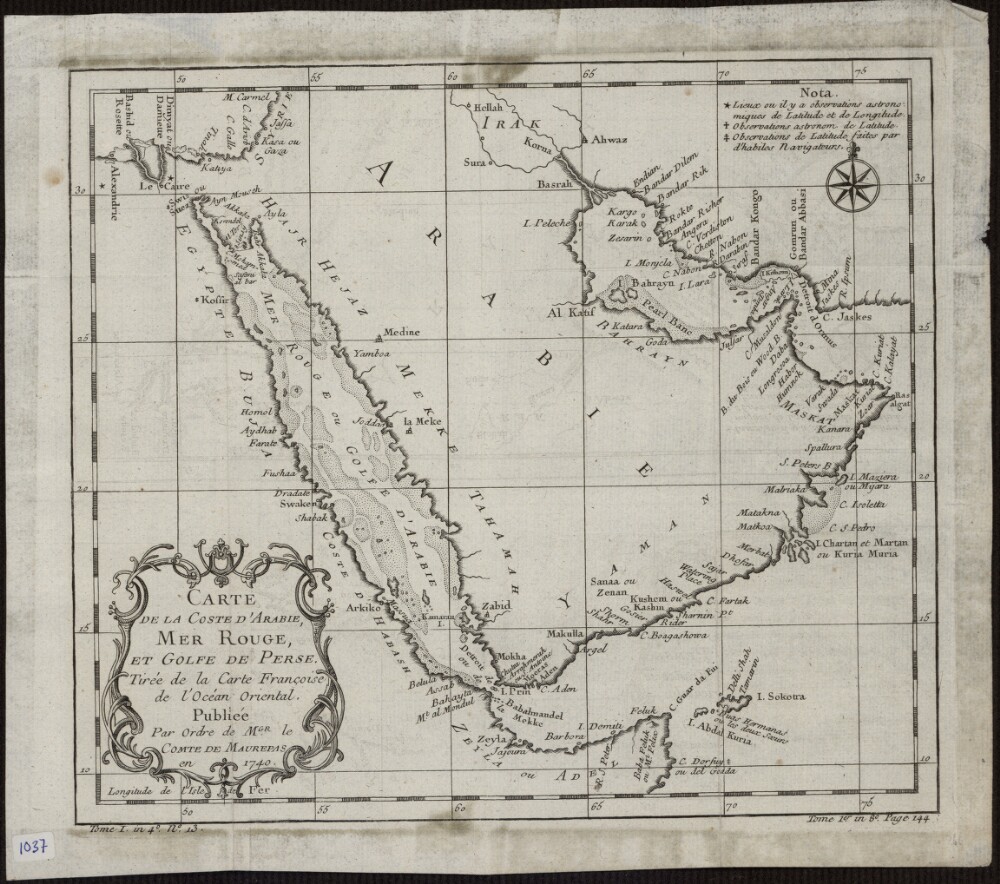
Abstract: This 1740 map is by the French cartographer and hydrographer Jacques-Nicolas Bellin (1703-72). It was published by order of Jean-Frédéric Phélypeaux, Count de Maurepas (1701-81), secretary of state under King Louis XV. The map focuses exclusively on the coastlines, and provides no detail about the interior of the Arabian Peninsula. It shows pearl banks along the coast from Bahrain to Julfar. Qatar is noted (“Katara”), but the peninsula that it occupies is not accurately drawn. Kuwait is not shown, but the island of “Peleche” is indicated. The Red Sea is indicated as Mer Rouge ou Golfe d’Arabie (the Red Sea or the Gulf of Arabia). The note at upper right explains the use of three different symbols: a star to indicate places whose locations had been determined by astronomical observations of latitude and longitude; a cross to indicate places whose locations had been determined by astronomical observations of (only) latitude; and a modified cross to indicate places whose locations had been determined by latitudinal observations made by skilled navigators.Physical description: 1 map; black and white; 20.50 x 23.50 centimeters
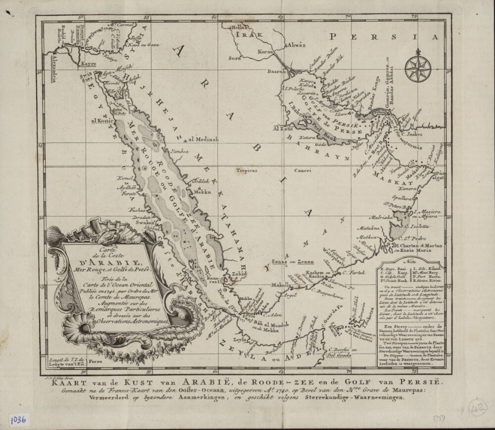
Abstract: This map of the coastlines of the Arabian Peninsula and adjacent regions is by the French hydrographer and cartographer Jacques-Nicolas Bellin (1703−72). Bellin was attached to the French Marine Office for more than 50 years and specialized in producing maritime maps. He also made most of the maps for Histoire générale des voyages: ou, Nouvelle collection de toutes les relations de voyages par mer et par terre, qui ont été publiées jusqu'à présent dans les différentes langues de toutes les nations connues (General history of the voyages, or, a new collection of all the accounts of voyages on sea and on land, which have been published up to the present in the different languages of all known countries), a 15-volume compendium edited by Abbé Antoine-François Prévost (1697–1763) and published between 1746 and 1759. This map appeared in the first volume of this work. The map shows coastlines, ports, and coastal shoals. At a time when the determination of location was still an inexact science, a note at upper right explains the use of three different symbols on the map: a star to indicate places where location had been determined by astronomical observations of latitude and longitude; a cross to indicate places where location had been determined by astronomical observations of (only) latitude; and a modified cross to indicate places where location had been determined by latitudinal observations made by skilled navigators.Physical description: 1 map ; 22 x 25 centimeters
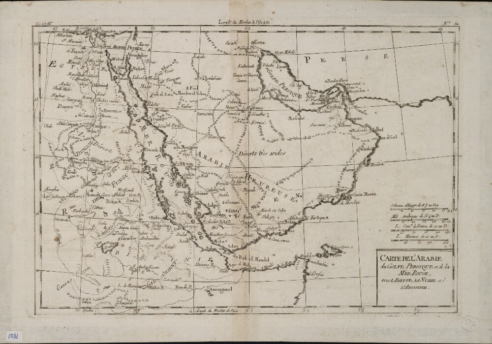
Abstract: This map of the Arabian Peninsula and surrounding areas was most likely created by the French cartographer and hydrologist Rigobert Bonne (1727−94). It is probably a proof copy of the map of the same title published in his Atlas des toutes les parties connues du globe terrestre (Atlas of all known land surfaces of the globe). The Arabian Peninsula is the main focus of the map, but it also covers much of the Nile Valley on the western shore of the Red Sea. The atlas was created to serve the global commercial and political interests of European traders and officials. Rigobert Bonne was one of many outstanding French cartographers of the 18th century. Self-taught in mathematics, he rose in the French administration to become chief hydrologist of the state Maritime Department. As a theoretician, he published a revision of global cartographic projection entitled Principes sur les mesures en longueur et en capacité (Principles of measurement of length and volume), a copy of which he sent to Thomas Jefferson in 1790 for discussion at the American Philosophical Society.Physical description: 1 map ; 21 x 31 centimeters
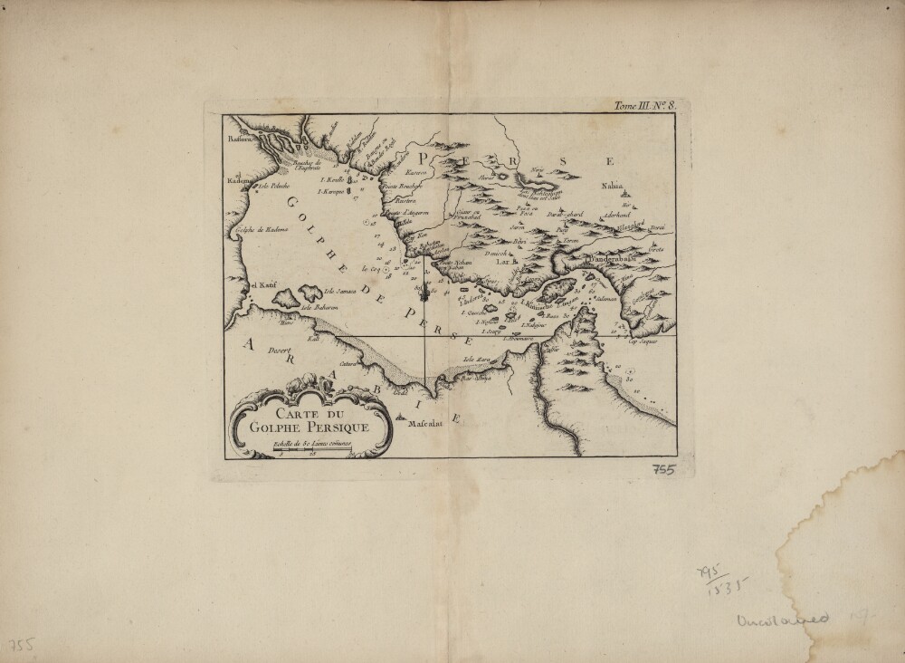
Abstract: This map of the Persian Gulf is by the French cartographer Jacques-Nicolas Bellin (1703−72). Qatar is shown as Catura. Cities on both the Arabian and Persian sides of the gulf are indicated, and the map shows a river emptying into the gulf at the port of Julfar (present-day Ra's al-Khaymah, United Arab Emirates). The scale is in common leagues, and there are no latitudinal or longitudinal lines. Trained as a hydrographer, Bellin was attached to the French Marine Office and specialized in producing maritime maps showing coastlines. His maps were in the tradition of Nicolas Sanson (1600–1667), the royal geographer to Kings Louis XIII and Louis XIV commonly known as the father of French cartography, and of Guillaume de l'Isle (1675−1726), one of a group of French cartographers that wrested mapmaking preeminence from the Dutch in the late 17th century. Like Sanson and de l’Isle, Bellin placed great emphasis on scientific accuracy rather than on artistic beauty for its own sake. In 1764, he published Le Petit Atlas Maritime: Recueil de Cartes et de Plans des Quatre Parties du Monde (Small maritime atlas: collection of maps and charts of the four parts of the world), a work in five volumes containing 581 maps. This map appeared as plate 8 in volume 3 of this work, containing maps of Asia (part I) and Africa (part II).Physical description: 1 map : copper engraving ; 22 x 17 centimeters
Abstract: Distinctive Features:Relief shown by hachures.Unsigned and undated. Labelled for reference with routes from Krasnovodsk shown in red.Physical description: Materials:Pen and ink on paperDimensions:240 x 184 mm
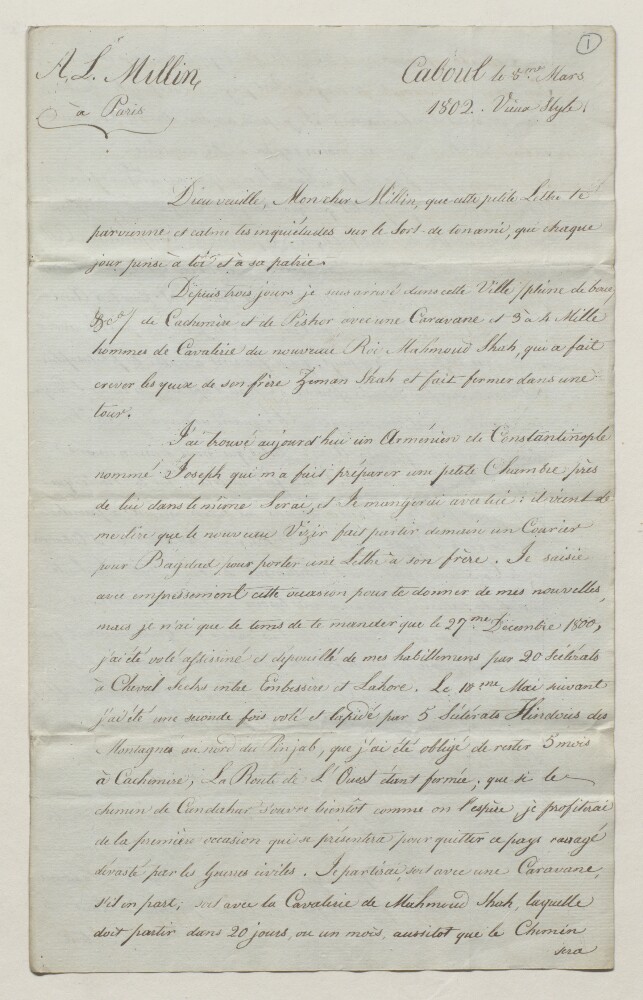
Abstract: A copy of an intercepted letter from Caboul [Kabul] from a French author to a correspondent in Paris, dated 8 March 1802.The author recounts his journey across India via Cachemire [Kashmir] to Caboul in a period of civil war, and his hopes to travel to Candahar [Kandahar] and Persia [Iran] and return to France. A postscript enquires after papers and objects sent by the author to Europe, remarks on the state of affairs in Cachemire, and complains of being surrounded by spies working for the English Government.A duplicate of this letter can be found in IOR/L/PS/9/76/249. An English translation of this letter is catalogued as IOR/L/PS/9/76/237.This letter was enclosed in the letter from Harford Jones, Resident in Bagdad [Baghdad], to Marquess Wellesley, Governor-General of Bengal, dated 20 June 1802 (IOR/L/PS/9/76/245).Physical description: 1 item (2 folios)