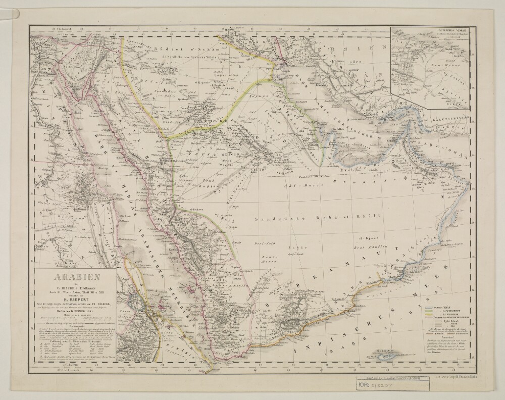
Abstract: Imprint:Berlin, Published by Dietrich Reimer. Lithographed by Ansalt von L. Kraatz.Distinctive Features:Below title: ‘Buch III, West-Asien, Theil XII u. XIII bearbeitet von H. Kiepert neue berichtigte Ausgabe, die Ortographie revidirt von Th. Nöldeke, mit Nachträgen aus den neusten Berichten von Guarmani und Palgrave’.Relief shown by hachures.Includes an inset map: ‘Südliches Oman’ in the top right-hand corner.Includes a table of Arabian words with German equivalent terms in the bottom left.Sultanates and provinces outlined in colour with a key in the bottom right-hand corner.Physical description: Dimensions:380 x 490 mm
cura et sumptibus Matth. Seutteri.Birds-eye view.Appears in: Atlas novus sive tabulæ geographicæ totius orbis faciem, partes, imperia, regna et provincias exhibentesexactissima cura iuxta recentissimas observation Matthaeo Seutter, 1745?. Vol.1, map No. 137.Includes a close-up view of Algiers and index.In German with a title in Latin.
Charten, Reisen und astronomischen Orstbestimugen gezeichnet von I. C. M. Reinecke.Covers Azerbaijan, Georgia and portions of Armenia and the Russian Federation.Relief shown by hachures.Colored in outline.Includes note.
nach den militœrischen Handkarten des Prinzen Eugen der Grafen Khevenhüller, Marsigli und Pallavicini geographisch aufgetragen, und nach den zuverloessigsten Nachrichten, und Reisebeschreibungen berichtiget im Jahre 1788 von Herrn Maximilian Schimek ; J. Alberti Sculp. ; F. Müller Scrip.Shows locations and dates of battles.Covers Serbia, Albania, Bosnia, Croatia, Dalmatia and portions of Macedonia and Hungary.Relief shown pictorially.Prime meridian: Ferro.North oriented toward the left.Includes ill.
entworfen von C. Vogel ; bearbeitet von B. Domann ; gestochen von Kern, Kühn u. Weiler.Covers Bosnia und Herzegovina, Croatia, Montenegro, Greece, Serbia, Romania, Bulgaria, Macedonia and portions of Turkey.North oriented toward the right.Relief shown by hachures. Depths shown by bathymetry."No. 52" and "Stielers Hand-Atlas No. 54".Includes index.Insets: Constantinopel (Scale 1:150,000) -- Athens und Piraeus (Scale 1:150,000) -- Das Nördliche Rümanien im Anschluss and die Hauptkarte (Scale 1:1,500,000) -- Strasse der Dardanellen (Scale 1:150,000) -- Der Bosporus (Scale 1:150,000).Originally issued on 4 sheets.
Redigiert v. Dr. K. Peucker ; Rudolph Maschek sculps ; Kartogr. Anst. v. Th. Bannwarth.Covers Romania, Bosnia and Hercegovina, Montenegro, Bulgaria, Macedonia, Albania, Greece, Cyprus and portions of Russia, Hungary, Croatia and Italy.Relief shown by hachures and spot heights. Depth shown by hachures.From: Scheda & Steinhauser Atlas. Sudost-Europa (Balkanländer) No. XV.Prime meridian: Greenwich and Ferro.
Nach Russischen und and Handschriften entworsen Strasburg bey Joh. Georg Treuttel ; I. P. Kremer delin ; B. F. Leizelt sc.Relief shown by hachures and pictorially.Prime meridian: Ferro.Includes ill.Map in German and French.
Covers Libya, Egypt, Sudan, the Arabian Peninsula, Lebanon, Syria, Iraq, Iran, the Balkan Peninsula, Turkey, Greece, Armenia, Azerbaijan and portions of Ethiopia and Russia.Relief shown by hachures and pictorially.Colored in outline.Inset: Neu Inventiert. Genealogischer Stamm-Baum Der Griechisch. Kaÿser Welche Theils Zu Constantinopel Theils Zu Trapezunt Residiret : desgleichen ein StammBaum Der Türckischen Kaÿser Bis Auf Den Heüt Zu Tag Regierenden Sultanins Kupfer gebracht u. verlegt von Matth. Seütter.Includes ill.In German and Latin.
nach älteren Quellen (v. Moltke, Heinrich Kiepert, Brit. Admiralitätskarten, v. d. Goltz, v. Diest u.a.) und eigenen Aufnahmen im Jahre 1900 gezeichnet von Rudolf Fitzner ; Hof. Stdr. v. J. G. Tiedmann Nachf.Relief shown by hachures. Depths shown by contours.Includes index.
Gestochen von F. Müller.Covers also portions of Albania, Macedonia, Bulgaria, Hungary, Romania, Croatia and Bosnia and Hercegovina.Relief shown pictorially.Includes ill.