Abstract: Annual administration report of the Bombay Presidency, providing a summary record of the main events and developments in each department of the Government of Bombay during the financial year 1865-66.The report is divided into the following headings, some of which are further divided into sub-headings:‘JUDICIAL’ (ff 7-30), consisting of: Legislative; Civil Justice; Court of Small Causes; Criminal Justice; Police; Jails‘REVENUE’ (ff 31-42), consisting of: Land Revenue; Alienated Revenue; Income Tax; Customs, Salt and Opium‘FINANCIAL’ (ff 43-50), consisting of: Finance; Mint; Paper Currency‘POLITICAL’ (ff 51-58), consisting of: Political; Kattywar [Kathiawar]; Kutch [also known as Kachchh]; Rewankanta [Rewa Kanthar]; Khadeish; Surat; Sind [Sindh]; Aden; Persian Gulf‘PUBLIC WORKS’ (ff 59-117), consisting of: Military Army; Ordance; Commissariat; Military Finance Offices; Civil Buildings; Public Improvements‘PUBLIC WORKS – RAILWAY’ (ff 118-134) consisting of: GIP [Great Indian Peninsular] Railway; BB and CI [Bombay, Baroda and Central Indian] Railway; Sind Railway; Indus Valley Survey; Indus Steam Flotilla‘MILITARY’ (ff 135-161)‘PENSIONERS’ COLONY AT CHALLISGAUM [Chalisgaon]’ (f 162)‘INDO-EUROPEAN TELEGRAPH’ (ff 163-251). This section gives details on the Mekran [Makran] Coast and Musandam telegraph station. This section also has appendices: A (letter from Colonel Frederic John Goldsmid, Director in Chief of Indo-European Telegraph, and a report by Major Smith on the Island of Angaum [Hengam]); B (a report by Colonel Goldsmid of his journey through Turkish Arabia [Ottoman Iraq] and Asia Minor [Turkey]); C (a letter from Colonel Goldsmid and reports by himself, Major Smith of the Royal Engineers, and Mr Johnstone, British Agent at Busrah [Basra], of the journey from Ispahan [Isfahan] to Gwadur [Gwadar] to survey the land for connecting the Persian [Iranian] and Mekran Coast land lines of the telegraph); and D (a letter from Colonel Goldsmid with enclosure proposing an alternative land line from Gwadur to join the main Persian line between Bushire [Bushehr] and Tehran).‘PUBLIC INSTRUCTION’ (ff 252-258)‘MEDICAL’ (ff 259-260)‘SURVEYS’ (ff 261-265), consisting of: Revenue Survey; Topographical Survey‘FORESTS’ (ff 266-268)‘EMIGRATION’ (f 269)‘MILLS’ (ff 270-272)‘MUNICIPAL’ (ff 273-275)‘ECCLESIASTICAL’ (ff 276-277)‘COTTON FRAUDS DEPARTMENT’ (ff 278-279)‘POPULATION, SIND’ (f 280)‘AGRICULTURE, SIND’ (f 281).A table of contents listing the headings and sub-headings of the report is on folios 5-6. There are two maps relating to surveys of the Indo-European Telegraph line.Physical description: 1 item (278 folios)
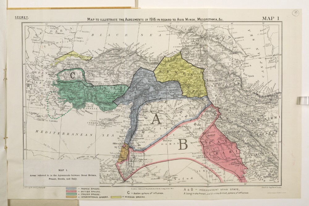
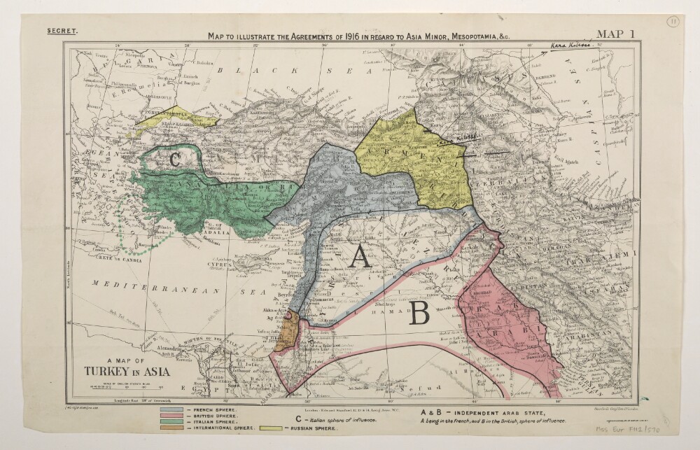
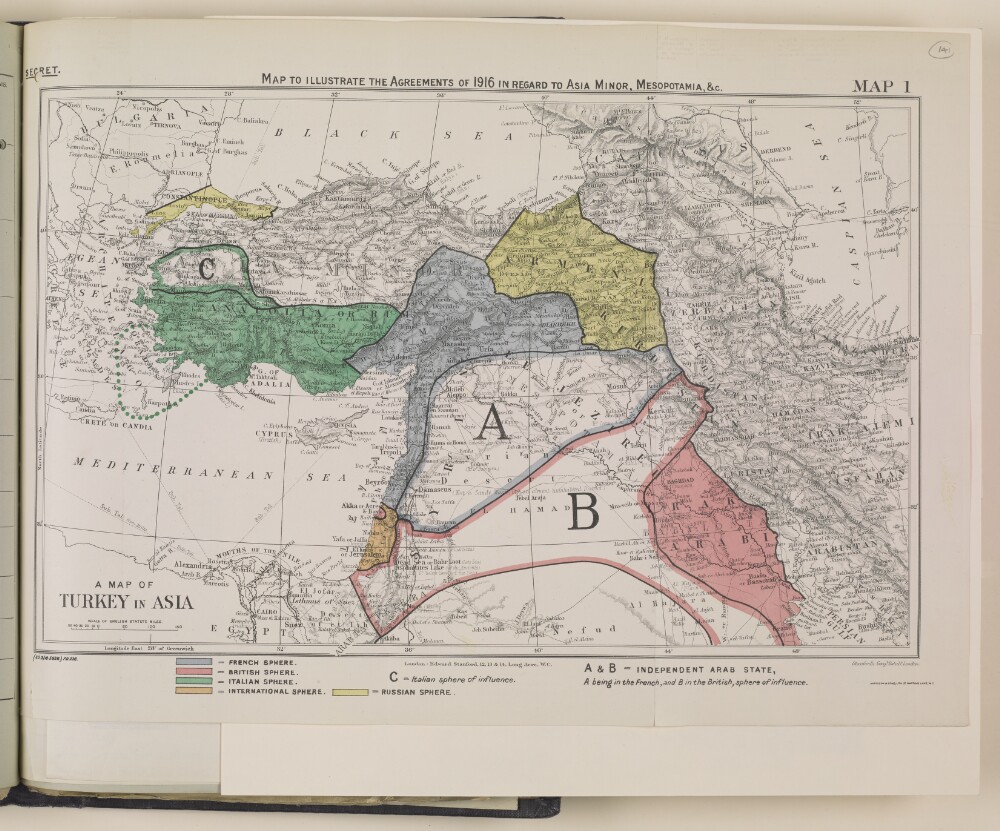
Abstract: Classified 'Secret'.Map forms a part of Mss Eur F112/570, ff 17-23.The original map bears the secondary title 'A Map of Turkey in Asia'. A small paper sheet has been pasted over this and bears a later secondary title 'Map 1. Areas referred to in the Agreements between Great Britain, France, Russia, and Italy.'Map bears the printed designation 'Map 1'. Depicts a proposed division of the Ottoman Empire into spheres of influence and protection by the Allied powers. The division is based on agreements reached between 1916 and 1918. Portrays hydrology, relief by spot heights and hachures, roads and tracks, railways, submarine telegraph lines, settlements, place names and international boundaries. Various blocks of overprinted colour shading correspond to French, British, Italian, Russian and International spheres of influence, including provision for an independent Arab state within the French and British spheres.The base map bears the imprint 'London: Edward Stanford, 12, 13 & 14, Long Acre, W.C.' The printer's imprint 'Harrison & Sons, Lith. St. Martins Lane, W.C.' and print code '(155.11/18.6423) F[oreign].O[ffice].238.' have been added later.Another copy of this map is at Mss Eur F112/570, f 26.Physical description: Materials: Printed in colourDimensions: 243 x 388mm, on sheet 287 x 449mm
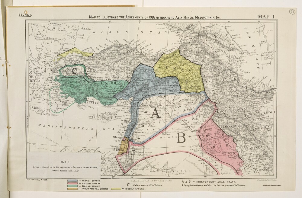
Abstract: Classified 'Secret'.Map forms a part of Mss Eur F112/570, ff 24-30.The original map bears the secondary title 'A Map of Turkey in Asia'. A small paper sheet has been pasted over this and bears a later secondary title 'Map 1. Areas referred to in the Agreements between Great Britain, France, Russia, and Italy.'Map bears the printed designation 'Map 1'. Depicts a proposed division of the Ottoman Empire into spheres of influence and protection by the Allied powers. The division is based on agreements reached between 1916 and 1918. Portrays hydrology, relief by spot heights and hachures, roads and tracks, railways, submarine telegraph lines, settlements, place names and international boundaries. Various blocks of overprinted colour shading correspond to French, British, Italian, Russian and International spheres of influence, including provision for an independent Arab state within the French and British spheres.The base map bears the imprint 'London: Edward Stanford, 12, 13 & 14, Long Acre, W.C.' The printer's imprint 'Harrison & Sons, Lith. St. Martins Lane, W.C.' and print code '(155.11/18.6423) F[oreign].O[ffice].238.' have been added later.Another copy of this map is at Mss Eur F112/570, f 19.Physical description: Materials: Printed in colour on paperDimensions: 243 x 388mm, on sheet 287 x 449mm
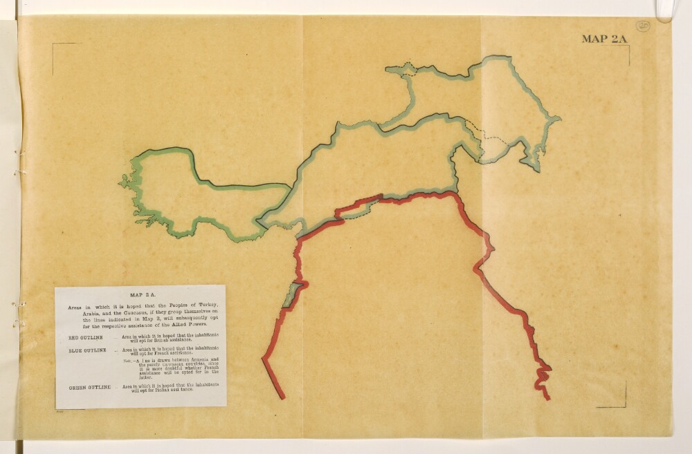
Abstract: Map is an overlay to Mss Eur F112/570, f 21 and forms a part of Mss Eur F112/570, ff 17-23.The title and legend are printed on a small paper sheet that has been pasted over the south-west corner of the map. Map portrays, by variously coloured boundaries, areas in which it is 'hoped that the inhabitants will opt for [British, French or Italian] assistance'. Bears the imprint '8146.' [Published by the Political Intelligence Department, Foreign Office, 21 November 1918.]Another copy of this map is at Mss Eur F112/570, f 27.Physical description: Materials: Printed in colour on tracing paperDimensions: 243 x 393mm, on sheet 290 x 450mm
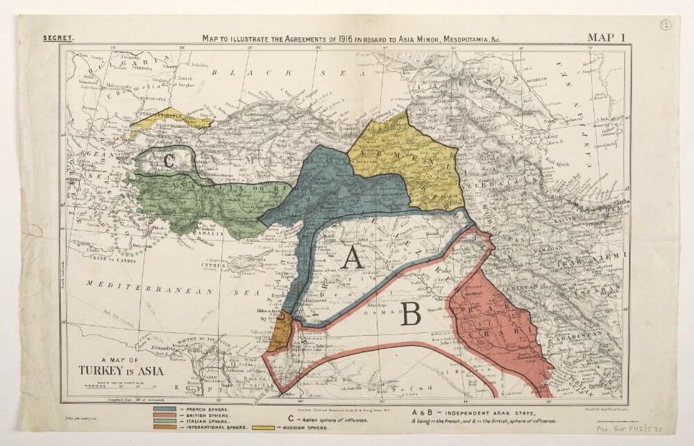
Abstract: Classified 'Secret'.The map bears a secondary title 'A Map of Turkey in Asia'.Bears the printed designation 'Map 1'. Depicts a proposed division of the Ottoman Empire into spheres of influence and protection by the Allied powers. The division is based on agreements reached between 1916 and the end of the First World War. Portrays hydrology, relief by spot heights and hachures, roads and tracks, railways, submarine telegraph lines, settlements, place names and international boundaries. A black overprint combined with watercolour washes show French, British, Italian, Russian and International spheres of influence, including provision for an independent Arab state within the French and British spheres. Some place names have been highlighted in manuscript.The base map bears the imprint 'London: Edward Stanford, 12, 13 & 14, Long Acre, W.C.' The printer's imprint 'Harrison & Sons, Lith. St. Martins Lane, W.C.' and print code '(40.10/18.6360)F[oreign].O[ffice].238.' have been added later.Verso bears an undetermined annotation.Physical description: Materials: Printed in colour, with additions in watercolour, ink and crayonDimensions: 243 x 388mm, on sheet 286 x 449mm
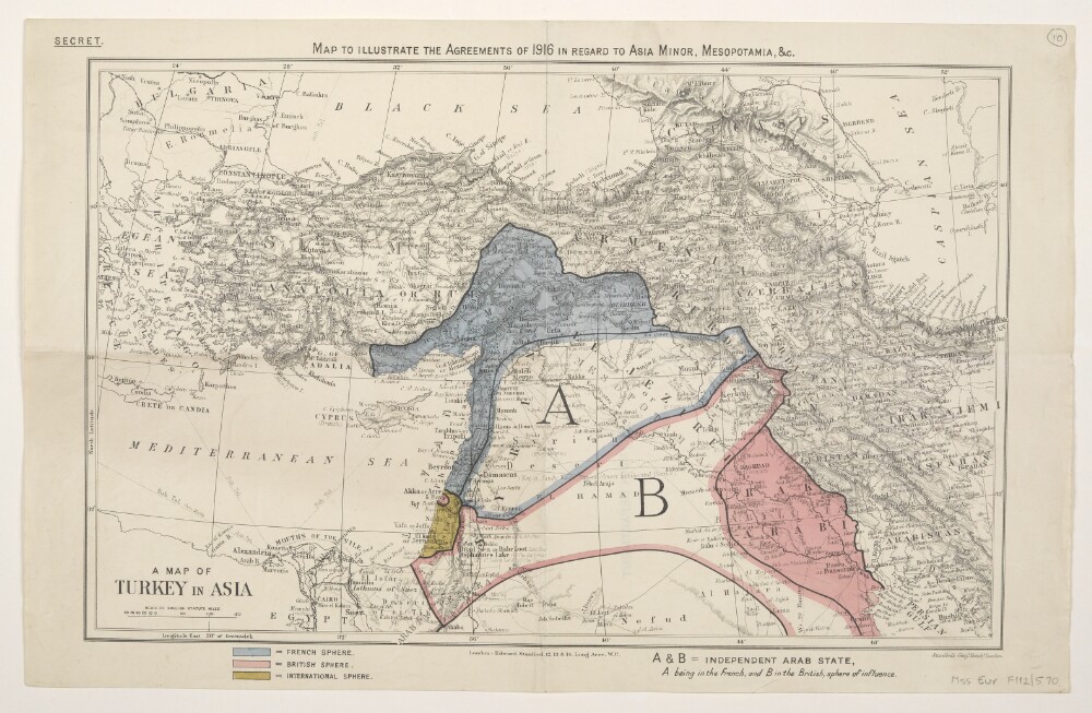
Abstract: Classified 'Secret'.The map bears a secondary title 'A Map of Turkey in Asia'.Depicts a proposed division of the Ottoman Empire into spheres of influence and protection by the Allied powers. The division is based on agreements reached between 1916 and the end of the First World War. Portrays hydrology, relief by spot heights and hachures, roads and tracks, railways, submarine telegraph lines, settlements, place names and international boundaries. A black overprint combined with watercolour washes show French, British and International spheres of influence, including provision for an independent Arab state within the French and British spheres.The base map bears the imprint 'London: Edward Stanford, 12, 13 & 14, Long Acre, W.C.'Verso bears the annotation '2nn' [?] and the stamp 'Eastern Department'.Physical description: Materials: Printed in colour, with additions in watercolour, pencil and rubber stampDimensions: 243 x 388mm, on sheet 284 x 447mm
Abstract: Three identical map sheets.Classified 'Secret'.The map bears a secondary title 'A Map of Turkey in Asia'.Bears the printed designation 'Map 1'. Depicts a proposed division of the Ottoman Empire into spheres of influence and protection by the Allied powers. The division is based on agreements reached between 1916 and 1919. Portrays hydrology, relief by spot heights and hachures, roads and tracks, railways, submarine telegraph lines, settlements, place names and international boundaries. Various blocks of overprinted colour shading correspond to French, British, Italian, Russian and International spheres of influence, including provision for an independent Arab state within the French and British spheres.The base map bears the imprint 'London: Edward Stanford, 12, 13 & 14, Long Acre, W.C.' The printer's imprint 'Harrison & Sons, Lith. St. Martins Lane, W.C.' and print code '(350.1/19.6648) F[oreign].O[ffice].' have been added later.Folio 14 has manuscript boundary additions in pencil and crayon.Physical description: Materials: Printed in colour, with manuscript additions in pencil and crayonDimensions: 243 x 388mm, on sheet 289 x 452mm
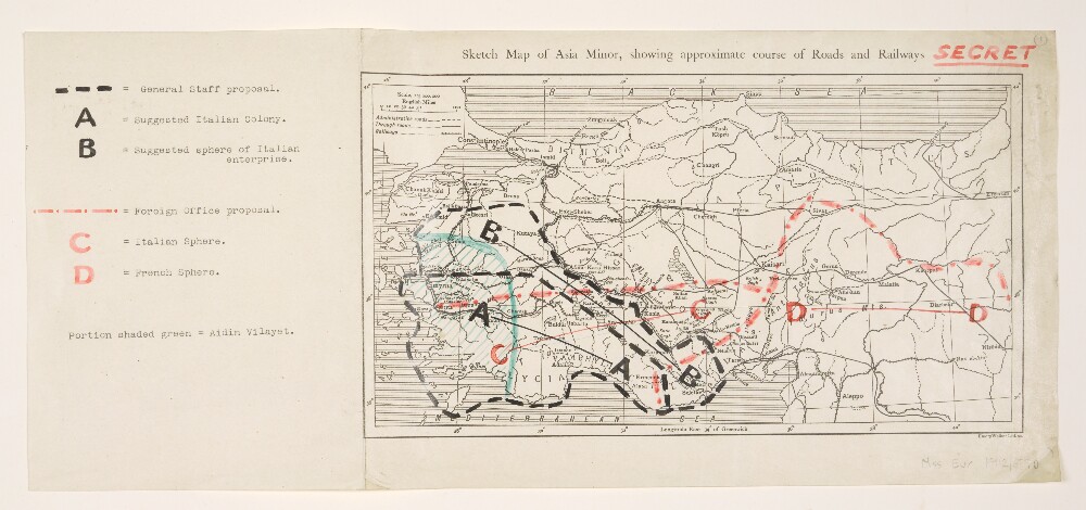
Abstract: The sheet bears the manuscript annotation 'Secret'.General purpose base map of Asia Minor with imprint 'Emery Walker Ltd. sc[ulpsit].' Portrays hydrology, roads, railways, settlements and place names. Date range derived from railway information.Manuscript and typescript additions relate to the Agreement of Saint-Jean-de-Maurienne [1917] and portray Aidin Vilayet together with General Staff proposals for an Italian Colony and sphere of enterprise, and Foreign Office Proposals for Italian and French spheres of influence.Physical description: Materials: Printed, with additions in typescript and coloured inkDimensions: 142 x 268mm, on sheet 191 x 433mm
Abstract: This map illustrates the agreements of 1916 in regard to Asia Minor, Mesopotamia, and nearby areas, and is colour coded to reflect the 'spheres of influence' of the following countries in 1916:France;Britain;Italy;Russia;International (collective sphere).The map is directly related to the synopsis (folios 136-137), and the agreements made with the French, Italians and Russians.Physical description: Materials: 1 paper folio with coloured ink
Abstract: This part of the volume consists of copies of enclosures to a despatch from the Government of Bombay Secret Department to the Secret Committee, Number 67 of 1850, dated 16 November 1850. The enclosures are numbered 3-4 and are dated 3 October to 15 November 1850.The papers relate to a proposed scheme to construct a railway from Europe, through Turkey, Asia Minor, Persia [Iran] and Beloochistan [Baluchistan] to the Indus.The correspondents is Samuel Hennell, Resident in the Persian Gulf.Physical description: 1 item (9 folios)