1 - 4 of 4
Number of results to display per page
Search Results
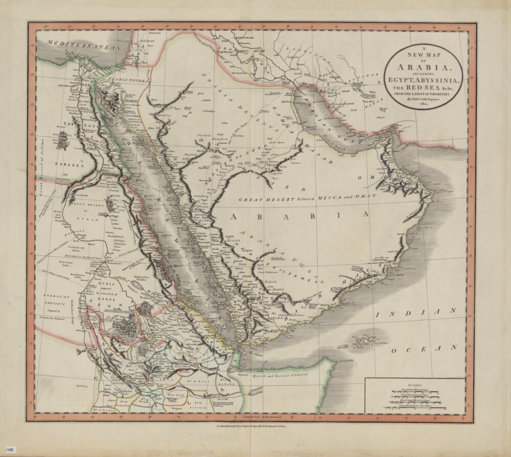
1. A New Map of Arabia, Including Egypt, Abyssinia, the Red Sea, from the Latest Authorities
- Description:
- Abstract: John Cary (circa 1754−1835) was a leading London engraver, map-, chart- and print-seller, and globe maker, active between 1787 and 1834. This map of 1804 shows the Arabian Peninsula and neighboring parts of Africa and the Middle East. Important caravan routes are marked, including the “route of the grand caravan of Sudan from the Niger to Cairo,” “route of the caravan from Batsora [Basra] to Aleppo,” “caravan of Darfowar [Darfur] to Mecca by Dongola,” “caravan of Sudan directly to Mecca by Suakem,” and several other caravan routes to Mecca. Many African kingdoms are shown, their borders marked with colored lines, as is a speculative source of the Nile. The northern coast of Somalia is called “Myrrh and Incense Country.” The zigzag line in the Red Sea indicates the course of La Venus, a French frigate that sailed on a voyage of discovery in the Red Sea, Persian Gulf, and Indian Ocean in 1785−88. The map includes many other notes that reflect the state of European geographic understanding of this region at the beginning of the 19th century. Four distance scales are given: great Arabian miles, Persian parasangs, British statute miles, and common French leagues.Physical description: 1 map : hand colored ; 44 x 50 centimeters
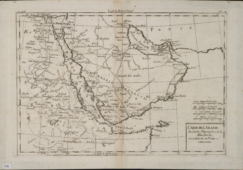
2. Map of Arabia, the Persian Gulf, and the Red Sea; Including Egypt, Nubia, and Abyssinia
- Description:
- Abstract: This map of the Arabian Peninsula and surrounding areas was most likely created by the French cartographer and hydrologist Rigobert Bonne (1727−94). It is probably a proof copy of the map of the same title published in his Atlas des toutes les parties connues du globe terrestre (Atlas of all known land surfaces of the globe). The Arabian Peninsula is the main focus of the map, but it also covers much of the Nile Valley on the western shore of the Red Sea. The atlas was created to serve the global commercial and political interests of European traders and officials. Rigobert Bonne was one of many outstanding French cartographers of the 18th century. Self-taught in mathematics, he rose in the French administration to become chief hydrologist of the state Maritime Department. As a theoretician, he published a revision of global cartographic projection entitled Principes sur les mesures en longueur et en capacité (Principles of measurement of length and volume), a copy of which he sent to Thomas Jefferson in 1790 for discussion at the American Philosophical Society.Physical description: 1 map ; 21 x 31 centimeters
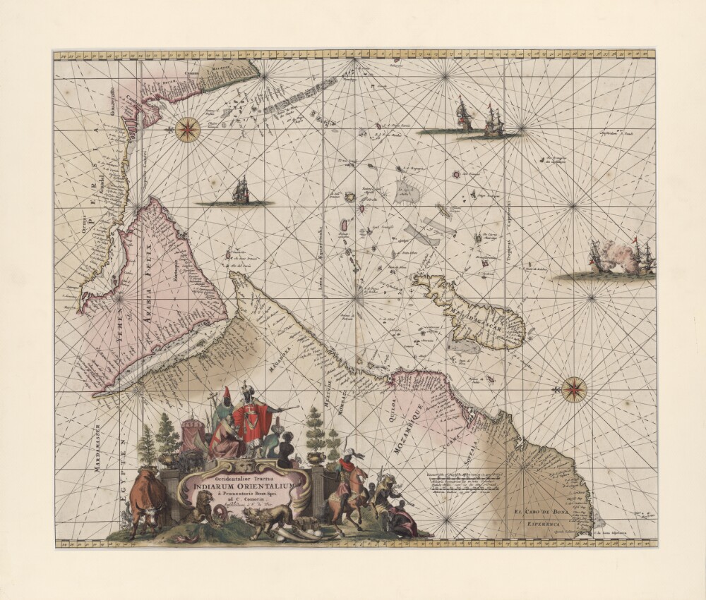
3. A Drawing (with a Western Perspective) of the East Indies from the Promontory of Good Hope to Cape Comorin
- Description:
- Abstract: This portolan map by the Dutch engraver, publisher, and map seller Frederick de Wit (1629 or 1630-1706) shows the Indian Ocean from the Cape of Good Hope to the west coast of India (Malabar). The map was first published in 1675 and was reprinted in 1715. It is oriented with east at the top. Kishm is placed in the present-day United Arab Emirates (UAE) and repeated as “Quaro” and “Quiximi.” The shape of the Arabian or Persian Gulf differs from that shown on other maps. There is a big island north of Bahrain Island named “Quezimi,” most likely another version of Qishm. Khorfan is shown twice: at one location in the present-day UAE in the Gulf of Corsca and the second on the Omani side, where it is called “Orfacan.” Mascalat, the region, is located at the center of the Arabian Peninsula, while the town of the same name is found south of Tablan, not far from the Arabian coast. “Ormuz,” a territorial name, is found around Oman and the present-day UAE. The Arabian Gulf is called “Mare Elcatif ol Sinus Persicus” (Al Qatif, Persian Gulf), while the Red Sea is marked “Mare Rubrum turcis Mare de Mecca olim Sinus Arabicus” (Red Sea, named Sea of Mecca by Turks and formerly known as the Arabian Gulf).Physical description: 1 map; color; 42 x 53.5 centimeters
4. Coll 54/2 'Middle East (Official) Committee: Working Party'
- Description:
- Abstract: The file contains papers relating to the Working Party of the Middle East (Official) Committee. It mainly consists of Working Party papers received by the Commonwealth Relations Office, and a register of these papers with notes at the back of the file.The file includes agendas for meetings of the Working Party. It also includes papers circulated to members of the Working Party for consideration at meetings, relating to the following subjects: economic and social development in the Middle East in general; the Iraq Central Development Board; the question of an International Bank Loan for Iraq; a visit to Bahrain in January/February 1949 by Matthew Thomas Audsley; the Persian [Iranian] Seven-Year Plan; employment of British experts in the Middle East; a survey of the oil resources of the Middle East; and economic factors in Middle East development.In addition, the file includes papers relating to economic and social development of the following places: Iraq; Greater Transjordan; Saudi Arabia; Cyrenaica, Tripolitania [Libya], Eritrea, and Somalia; the Colony of Aden and the Aden Protectorate; the Lebannon; Ethiopia; Sudan; and Yemen.Physical description: Foliation: the foliation sequence (used for referencing) commences at the front cover with 1, and terminates at the last folio with 320; these numbers are written in pencil, are circled, and are located in the top right corner of the recto side of each folio.A previous foliation sequence, which is also circled, has been superseded and therefore crossed out.