1 - 3 of 3
Number of results to display per page
Search Results
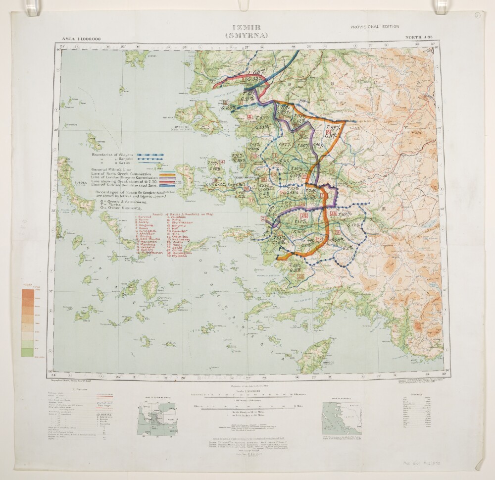
1. 'Izmir (Smyrna)'. With boundaries added in manuscript
- Description:
- Abstract: Relates to the Treaty of Sèvres (1920).Geographical Section, General Staff No. 2555, Sheet North J-35, Izmir (Smyrna), Provisional Edition. Covers Izmir, western Turkey and surrounding land and sea areas to a radius of approximately 150 miles. Portrays hydrology, soundings, relief by spot heights and gradient tints, roads and tracks, railways, telegraphs, settlements, place names, post and telegraph offices, and international and internal boundaries. Bears the imprint 'Compiled at the Royal Geographical Society under the direction of the Geographical Section, General Staff. Drawn and printed at the War Office, 1916.'Manuscript annotations depict boundaries of Vilayets, Sanjaks and Kazas; General Milne's Line; Line of Paris Greek Commission; Line of London Smyrna Commission; Line showing Greek claim of 19 February 1920; Line of Turkish Demilitarized Zone; and percentages of Races for complete Kazas, together with a list of Kazas. The manuscript annotations have been used in the compilation of folio 6.Verso bears the annotation 'Smyrna Sanjak'.A copy of this map, without the annotations, is filed at Maps MOD GSGS 2555.Physical description: Materials: Printed in colour, with manuscript additions in coloured ink, watercolour and crayonDimensions: 446 x 541mm, on sheet 636 x 650mm
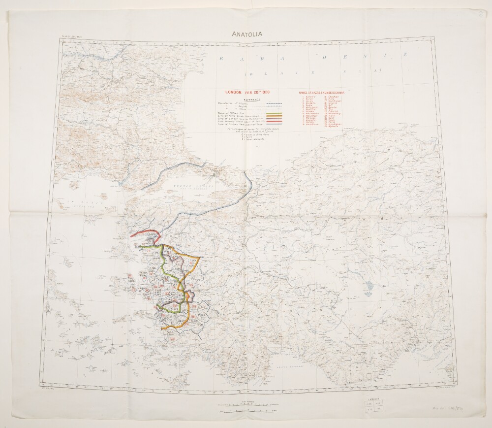
2. 'Anatolia'. With boundaries added to 20 February 1920
- Description:
- Abstract: Relates to the Treaty of Sèvres (1920)Created by the War Office August 1919 with boundaries added to 20 February 1920. Geographical Section, General Staff No. 2931, Sheet 'Anatolia'. Portrays hydrology, soundings, relief by spot heights and contours, railways, settlements, place names, and international and internal boundaries. Base map compiled from GSGS 2555 sheets NJ-35 (dated 1916), NJ-36 (1916), NK-35 (1919) and NK-36 (1916); projection information also derived from this source.Colour overprints, partly compiled from the information in folio 5, cover the Izmir (Smyrna) and Istambul [Istanbul] areas of western Turkey and depict boundaries of Vilayets, Sanjaks and Kazas; General Milne's Line; Line of Paris Greek Commission; Line of London Smyrna Commission; Line showing Greek claim of 19 February 1920; Line of Turkish Demilitarized Zone [Zone of the Straits]; and percentages of Races for complete Kazas, together with a list of Kazas.Verso bears the annotation 'Dardanelles'.Physical description: Materials: Printed in colour, with manuscript additions in pencilDimensions: 595 x 722mm, on sheet 713 x 830mm
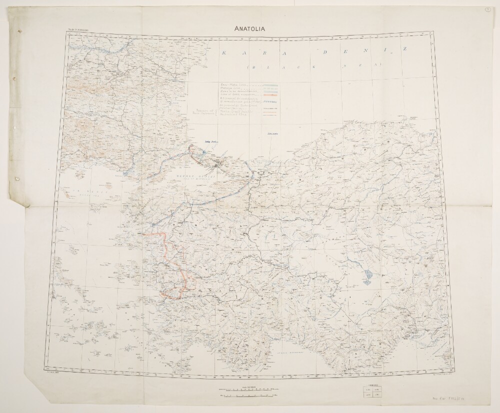
3. 'Anatolia'. With boundaries and proposed boundaries added to 30 March 1920
- Description:
- Abstract: Relates to the Treaty of Sèvres (1920).Created by the War Office August 1919 with boundaries and proposed boundaries added to 30 March 1920. Geographical Section, General Staff No. 2931, Sheet 'Anatolia'. Portrays hydrology, soundings, relief by spot heights and contours, railways, settlements, place names, and international and internal boundaries. Base map compiled from GSGS 2555 sheets NJ-35 (dated 1916), NJ-36 (1916), NK-35 (1919) and NK-36 (1916); projection information also derived from this source.Manuscript additions cover the Izmir (Smyrna) and Istambul [Istanbul] areas of western Turkey and depict the Enos-Midia Line; the Chatalja Line; the Zone to be demilitarised [Zone of the Straits]; the Line of Greek occupation; the W[ar]O[ffice] proposal for modification of demilitarised zone (11th March); the W[ar]O[ffice] proposal for Turko-Greek frontier (30 March 1920); the Turko-Greek frontier (as decided by Peace Conference); and the Neutralised Zone (as decided by Peace Conference). A small number of other features are also highlighted.Physical description: Materials: Printed in colour, with manuscript additions in pencil, crayon and coloured ink, on paperDimensions: 595 x 722mm, on sheet 713 x 860mm