« Previous |
1 - 12 of 19
|
Next »
Number of results to display per page
Search Results
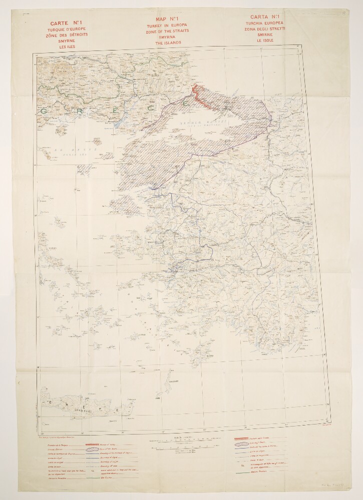
1. 'Map No. 1. Turkey in Europa. Zone of the Straits, Smyrna, the [Aegean] Islands'
- Description:
- Abstract: Title also given in French ( Carte No. 1. Turquie d’Europe, Zône des Détroits, Smyrne, les Iles) and Italian ( Carta No. 1. Turchia Europea. Zona degli Stretti, Smirne, Le Isole).Relates to the Treaty of Sèvres (1920).Comprises a base map and overprints, and covers an area within an approximately 240-mile radius of Smyrna [Izmir] in western Turkey and extending north-westwards into Greece.The base map portrays hydrology, soundings, relief by spot heights and contours, railways, settlements, post and telegraph offices, place names, and international and internal boundaries. Bears the French imprint Fond établi par le Service Géographique Britannique[Base map established by the British [army] Geographical Section]. North of 36⁰N the base is compiled from GSGS 2555 sheets NJ-35 (dated 1916), NJ-36 (1916), NK-35 (1919) and NK-36 (1916); south of this, map detail is coarser. Projection information is also derived from GSGS 2555.Colour overprints portray the Turkish border, Zone of the Straits, Smyrna Enclave, boundaries of vilayets, sanjaks and casas, islands attributed to Italy and the former frontier. Overprint legend in English, French and Italian. Bears the imprint S[ervice].G[éographique de l']A[rmée]. 28 7.20.The verso bears the annotation 'Straits'.Physical description: Materials: Printed in colourDimensions: 830 x 633mm, on sheet 1070 x 745mm
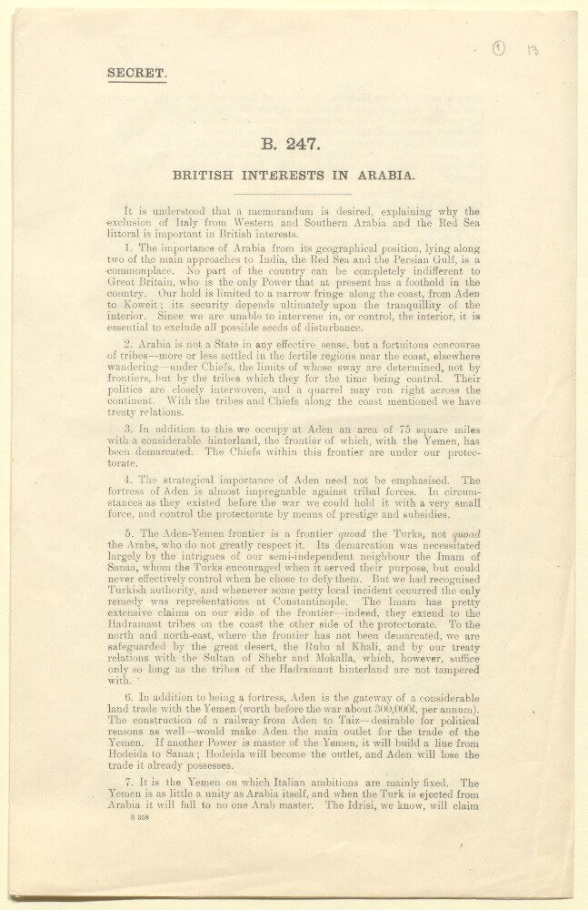
2. 'British interests in Arabia'
- Description:
- Abstract: This memorandum was written by Sir Frederic Arthur Hirtzel in January 1917. Its purpose is to explain 'why the exclusion of Italy from Western and Southern Arabia and the Red Sea littoral is important in British interests'. It notes the importance of Arabia lying as it does along two of the main approaches to India from Europe. Hirtzel's memorandum also notes the absence of an effective state in Arabia, and the concomitant influence of tribes and their chiefs.It reviews the strategic importance of Aden and its protectorate along with the significance of the Aden-Yemen frontier in the context of British relations with the Imam of Sanaa and Turkey (paragraphs 4-5). It notes that the Italian ambitions are mainly focused on the Yemen and that the Italo-Turkish war made Italy the most unpopular 'Christian power' in the Muslim world. It analyses the implications of any British consent to an Italian occupation of the Yemen.It concludes that the 'present war has shown the use that may be made against us of Islam' and contends that the success of H M Government in the Middle East 'depends to a large extent on the transfer of the Caliphate from Turkey to Arabia. This in turn depends on the possibility of making the ruler of the Hejaz sufficiently strong to be able to pose as an independent sovereign. This again depends upon keeping the Christian powers at a sufficient distance.' The memorandum finishes by noting that it was for these reasons Britain took the precaution of inserting in the Anglo-French convention [Sykes-Picot agreement] that the British and French Governments agree that they will not themselves acquire and will not consent to a third Power acquiring territorial possessions in the Arabian peninsula with a sphere of influence being seen as equivalent to territorial possession.Physical description: Foliation: The foliation sequence commences at the first folio and terminates at the last folio; these numbers are written in pencil, are circled, and are located in the top right corner of the recto side of each folio. Pagination: The booklet also has an original printed pagination sequence.
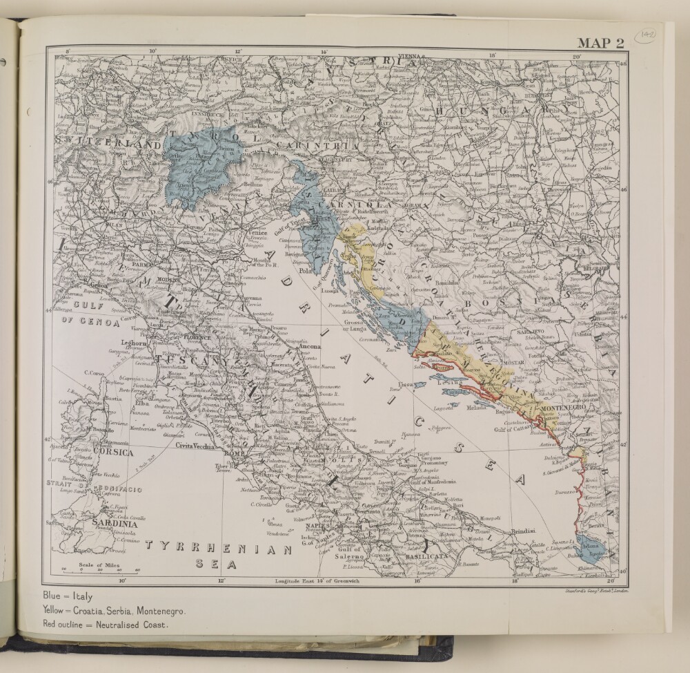
3. 'Map 2'
- Description:
- Abstract: This map focuses on the territories surrounding the Adriatic Sea, and is directly related to page 2 of the synopsis (folio 136v), which provides details of an agreement Britain made with Italy in 1915. The map reflects the details of the agreement: the territory marked in blue was to be awarded to Italy, the area marked red was to be neutralised, and the yellow areas were to go to Serbia, Croatia, and Montenegro.Physical description: Materials: 1 paper folio with coloured ink
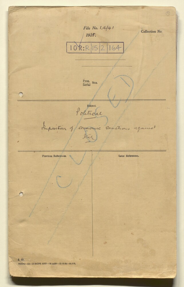
4. 'File 1/A/41 Imposition of economic sanctions against Italy'
- Description:
- Abstract: The file concerns the decision of Shaikh Hamad bin Isa al-Khalifah [Ḥamad bin ‘Īsá Āl Khalīfah], Ruler of Bahrain, on his own initiative to prohibit the import of goods from Italy, and the response to that decision of British officials. The Shaikh's action was an expression of sympathy with moves by the League of Nations to end Italy's war in Abyssinia.The principal correspondents are the Political Agent, Bahrain (Lieutenant-Colonel Percy Gordon Loch); the Political Resident in the Persian Gulf (Lieutenant-Colonel Trenchard Craven William Fowle); officials of the Government of Bahrain; the Government of India; and the Foreign Office.The papers cover: discussion of the Shaikh's decision by the Political Agent, Bahrain and the Political Resident, the practical effects of which were thought to be 'small' (folios 2-6); the decision to defer an approach to other Gulf rulers to see if they wished to show sympathy (folios 7-10); instructions in the matter from the Government of India, which were that rulers of Gulf states should be advised to apply sanctions simultaneously with member states of the League of Nations (folios 11-26); the Political Resident's advice that it would be best not to approach other Gulf rulers, and to annul the Shaikh's proclamation, as the moves would be seen in Italy as an attempt by the British to inspire hostility in countries outside the British Empire, and copies of relevant notices ( alans) issued by the Government of Bahrain (folios 27-43); and correspondence concerning the lapse of the prohibition following the end of hostilities between Italy and Abyssinia (folios 44-47).The Arabic language content of the file consists of four folios, mainly copies of bilingual Arabic and English notices issued by the Government of Bahrain.Physical description: Foliation: the main foliation sequence (used for referencing) commences at the front cover with 1 and terminates at the inside back cover with 53; these numbers are written in pencil, are circled, and are located in the top right corner of the recto side of each folio. An additional foliation sequence is also present in parallel between ff 2-52; these numbers are also written in pencil, but are not circled, and are located in the same position as the main sequence.
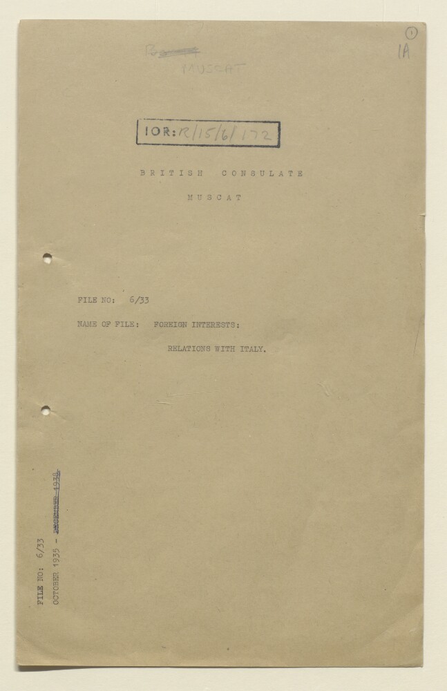
5. 'File 6/33 Foreign Interests: Relations with Italy'
- Description:
- Abstract: This file contains correspondence between British officials as to whether or not the Gulf states should be compelled to partake in a League of Nations boycott of Italian goods.Physical description: Foliation: the main foliation sequence (used for referencing) commences at the front cover with 1, and terminates at the inside back cover with 22; these numbers are written in pencil, are circled, and are located in the top right corner of the recto side of each folio. An additional foliation sequence is present in parallel; these numbers are also written in pencil, but are not circled.
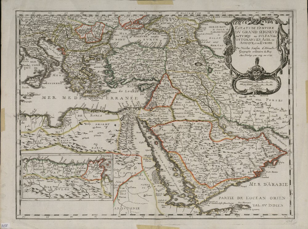
6. Lands of the Emperor of the Turks or the Ottoman Sultan in Asia, Africa, and Europe
- Description:
- Abstract: This map shows the Ottoman Empire as it was conceived in Europe in the last quarter of the 17th century. It is a reprint, dated 1679, of an earlier edition possibly included in a series of world atlases published by Nicolas Sanson (1600−1667) in the middle of the century. The map shows geological features, such as rivers, deserts, and mountain ranges. Cities and towns are indicated, and colored lines are used to mark the borders of kingdoms. An inset map at the lower left shows the extension of the southern coast of the Mediterranean, westward to Algeria. Place-names are in French. Sanson is considered by many to be the founder of the French school of cartography. Originally from Abbeville, he was also known as Sanson d’Abbeville. He was trained as a military engineer but became a prolific cartographer who produced more than 300 maps. Around 1643, he began publishing maps, working with publisher Pierre Mariette. In the period from the 16th to the 18th centuries, French, British, and Dutch mapmakers competed to supply the growing demand for maps of the East as European commerce expanded in regions beyond the Mediterranean. Sanson was among the early cartographer-publishers to profit from this demand. He established a dynasty of geographers and mapmakers that endured for a century.Physical description: 1 map : hand colored ; 39.2 x 54.5 centimeters
7. The Greater Luminary
- Description:
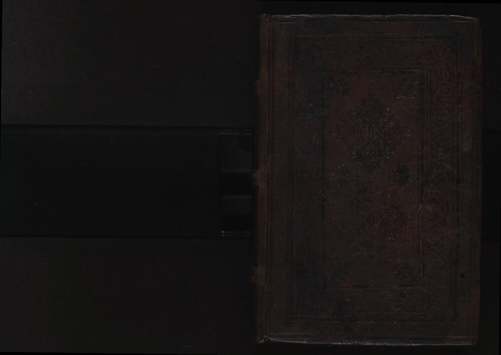
- Abstract: This volume contains Luminare Maius (The greater luminary), and an antidotarium (book of antidotes), by Joannes Jacobus de Manliis (1490). It is based on the works of the Nestorian Persian physician Yūḥannā Ibn Māsawayh (circa 777–857), known in the Latin West as Mesue, and “other distinguished physicians.” Also included is an edition of Pandectarum Medicinae (Encyclopedia of medicaments) by Matteo Silvatico (also known by his Latinized name, Mattheus Sylvaticus, circa 1280–circa 1342), which consists of an alphabetized list of medications, primarily of herbal origin. Sylvaticus relied and expanded on the work of Simon of Genoa (flourished end of 13th century), who provided a lexicon of Latin, Greek, and Arabic medical terms in his dictionary, Clavis Sanationis. Sylvaticus also drew on the works of earlier Greco-Roman authorities, such as Dioscorides, Galen, and Paul of Aegina (circa seventh century). Other important sources were scientists in the Islamic world, such as the Persian physicians Ibn Sīnā (known as Avicenna in the Latin West, circa 980–1037) and Rāzī (Rhazes in the Latin West, circa 865–circa 925), and the Andalusian scientist Ibn Rushd (Averroes in the Latin West, 1126–98). For each of the 702 entries in this work, Sylvaticus provides the Arabic and Greek names, in addition to information about the medicinal properties of the material or plant in question. As in his Clavis Sanationis, for each letter of the Latin alphabet, a short introduction provides notes on transliteration from the Greek and Arabic into Latin. This edition was commissioned by Octavianus Scotus of Modena and produced in Venice in 1498 by the printer Bonetus Locatellus (active 1486–1523). It is not the earliest extant printing of this work. Other early printings include those from Naples (1474), Vicenza (1480), and Venice (1480, 1492, and 1499). Sandwiched between Luminare Maius and the Pandectarum Medicinae is a short work, Lumen Apothecarium, also by Manliis, which consists primarily of a table of contents for Luminare Maius.Physical description: 253 pages : illustrations ; 30 centimeters
8. Commentary of Hugo of Sienna on the First [Book] of the Canon of Avicenna Together with His Questions
- Description:
- Abstract: Ugo Benzi (also known as Hugo of Siena) was born in Siena about 1370. Educated in the liberal arts, he later developed an interest in medicine and undertook formal studies at the University of Bologna. He became a renowned physician, scholar, and teacher of medicine at several universities in Italy. He prepared commentaries on the medical classics of the time, works by the Greek Hippocrates, the Roman Galen, and the famous Islamic scholar Abū ‘Alī al-Ḥusayn ibn ‘Abd Allāh ibn Sīnā (980–1037), commonly known as Avicenna. These texts formed the basis of medical education in the West from about 1300 to 1600. Benzi’s extensive studies and reputation as a man of learning and scholarship helped to shape the growth of medicine as a respected profession based on a repository of authoritative knowledge. This early printed book is a commentary on al-Qānūn fī al-ṭibb (The canon of medicine), Avicenna’s encyclopedic masterpiece summarizing all of the medical knowledge of the time. The commentary deals with the most important sections of Avicenna’s work. These concern the fundamental concepts of medicine and general symptoms of disease in: Book One, “Things in the overall knowledge about medicine;” Treatise One, “Medicine and the themes of nature;” and Treatise Two, “Diseases, causes, and symptoms.”Physical description: 125 leaves; 29 centimeters (folio)
9. Three Books on the Soul
- Description:
- Abstract: Muhammad ibn Ahmed ibn Rushd (also known by the Latinized version of his name, Averroes, 1126–98) was a Muslim jurist, physician, and philosopher from Cordoba, Spain, best known in the West for reintroducing Aristotle to Europe and in the East for his medical works. He studied theology, law, and medicine, and wrote important works in all of these fields. He served as the religious judge of Seville in 1169–72 and as the chief judge of Cordoba in 1172–82. In 1169, Ibn Rushd began writing a series of commentaries on Aristotle, whose works he probably read in Arabic and Syriac translations from the original Greek. Over a period of nearly three decades, he produced commentaries on nearly all of Aristotle’s writings. His method was to produce short, medium, and long commentaries on the same work, aimed at readers with different levels of understanding. Largely forgotten in the Latin West since the sixth century, Aristotle underwent a revival in the 12th and 13th centuries, when his works were translated into Latin and studied by Christian and Jewish philosophers and theologians such as Thomas Aquinas (1225–74) and Maimonides (1135–1204). From then until the 17th century, European scholars read Aristotle in editions that included commentaries by Ibn Rushd and a school of thought known as Averroism flourished in leading universities. Presented here is a 1521 edition of Ibn Rushd’s commentary on De Anima (On the soul) published in Pavia, Italy. Also included is Theiser (Facilitation of treatment) by Seville physician Abu Marwan Abd al-Malik Ibn Zuhr (also called Avenzoar, 1090–1162) and a commentary on Averroes (Ibn Rushd) by Marco Antonio Zimara (1460–1523), an Italian Aristotelian who edited the works of Aristotle, Averroes, and other philosophers.Physical description: 80 pages ; 29 centimeters
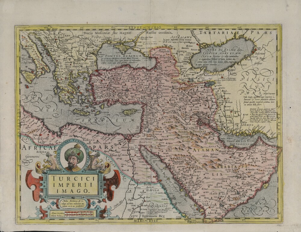
10. Map of the Turkish Empire
- Description:
- Abstract: This map shows the Ottoman Empire as it appeared in the early 17th century. It details Ottoman territories in Asia, Africa, and Europe, and includes Persia, Transcaucasia, Ethiopia, and other surrounding lands. Topographic features, place-names, and populations are definitively marked, although the nomenclature of the time differs markedly from that used today. The Red Sea is termed the Sea of Mecca, for example, and the Persian Gulf is called the Sea of Alcatif. The map sometimes has been identified as a part of Atlas sive Cosmographicae Meditationes de Fabrica Mundi et Fabricati figura (Atlas of the world: finely engraved and drawn), produced by Jodocus Hondius following the work of Gerard Mercator. There is no evidence on the map itself to sustain that identification, nor is a date of publication supplied. Ottoman lands are hand-colored in red, except for the European territories. The vivid coloring is not contemporary with the production of the map and was probably added in the 19th century after Greece and the Balkan lands, which are not colored, were freed from Ottoman rule. Different lettering denotes different geographic and ethnographic features. Italics are generously used, and geometric shapes and shading are used to indicate mountain ranges and maritime littorals. The title cartouche indicates that Hondius, the supposed creator, based his map on Mercator’s projection. The cartouche itself is of interest for its cameo portrait entitled “Sultan Mahumet Turcorum Imperat” (Sultan Muhammad Emperor of the Turks), probably meant to represent Sultan Mehmed II (1432−81), known as Mehmed the Conqueror.Physical description: 1 map : hand colored ; 34 x 47 centimeters
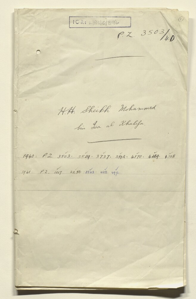
11. PZ 3503/40 'HH Shaikh Muhammed bin Isa Al Khalifa'
- Description:
- Abstract: File contains correspondence regarding assistance provided by the British Government to transport Mohamed bin Isa al Khalifa, the brother of Hamad bin Isa al Khalifa [King of Bahrain], his son, and three companions from Malta to Alexandria, following the recall of Italian ship the Calitea to Italy at the start of the Second World War. The main correspondents are: the Political Resident in the Persian Gulf; the Officer Administering the Government of Malta; the Secretary of State for the Colonies; the Under Secretary of State; India Office (Roland Tennyson Peel and John Percival Gibson) and the Political Agent, Bahrain. In general there is a willingness from government officials to assist; however some concern over the loyalty of Mohamed bin Isa al Khalifa to the Crown is expressed.Physical description: Foliation: the foliation sequence for this description commences at the front cover with 1, and terminates at the inside back cover with 27; these numbers are written in pencil, are circled, and are located in the top right corner of the recto side of each folio.
12. Tales of Heroes and Great Men of Old
- Description:
- Abstract: Siyar al-Abtal wa-al-Uzama’ al-Qudama’ (Tales of heroes and great men of old) introduces young readers to classical mythology. It typifies many publications of the British and American missionaries in the Levant in the mid-to-late 19th century. Uplifting humanistic writing of this kind was new to the Middle East. It grew directly from the children’s book movement in Britain in the first half of the century, led by the British Tract Society, which later reinforced the efforts of American missionaries to the Middle East, such as Cornelius Van Dyck. The book includes such stories as “Jason and the Golden Fleece,” “The Battle of Thermopylae,” “Hector and Achilles,” and a description of the Olympiad. The author claims that the stories and myths illustrate “numerous ethical benefits such as control of our appetites and rejection of vengeance, injustice and blame in all their forms.” He declares further that “Greek morality exemplifies Christian morality in that it offers clear demonstration of self-respect and regard for the needs of others over our own needs.” Publication of the book was the result of cooperation between the British Tract Society, which provided funds, and the American Press in Beirut, which printed this generously illustrated book. Copies presumably were distributed at Protestant schools and churches operated by both British and American missionaries. Neither the author nor translators are named in the book, but the edition of 1883 mentions that it was written by S.S. Pugh, a British author of edifying books. Secondary sources identify the translators as Ya’qūb Sarrūf and Faris Nimr, classmates and later instructors at the Syrian Protestant College. They co-founded the influential periodicals al-Muqtataf (The selected) and al-Muqattam (The Muqattam Hills) and were granted honorary doctorates by New York University.Physical description: 310 pages ; 20 centimeters
- « Previous
- Next »
- 1 Current Page, Page 1
- 2