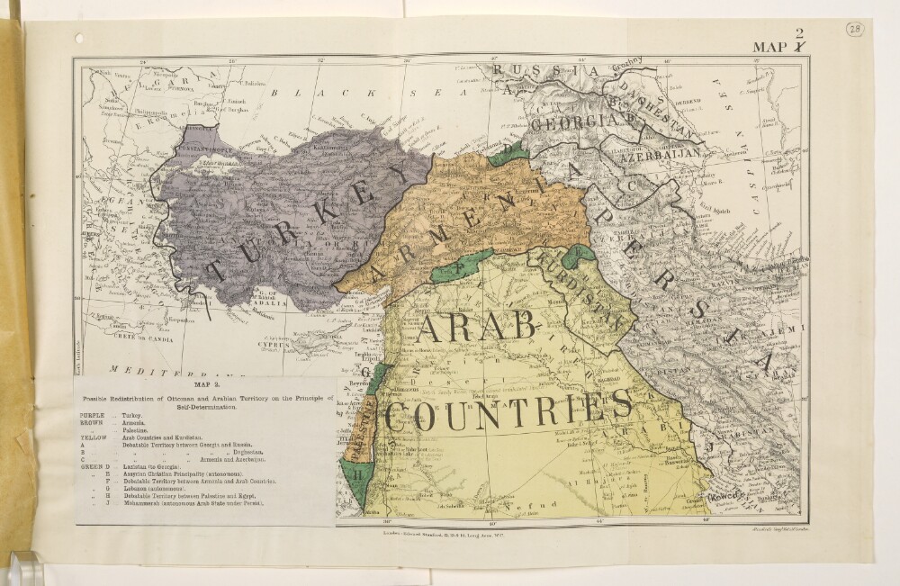
Abstract: Map forms a part of Mss Eur F112/570, ff 24-30.The title and legend are printed on a small paper sheet that has been pasted over the south-west corner of the map. The map number '1' has been deleted and replaced by '2'. Map portrays hydrology, relief by spot heights and hachures, roads and tracks, railways, submarine telegraph lines, settlements, place names and international boundaries. Map also depicts, by variously coloured shading, areas in which self-determination is deemed possible. Bears the imprint 'London: Edward Stanford, 12, 13 & 14, Long Acre, W.C.' [Published by the Political Intelligence Department, Foreign Office, 21 November 1918].An overlay to this sheet is at Mss Eur F112/570, f 27.Another copy of this map is at Mss Eur F112/570, f 21.Physical description: Materials: Printed in colourDimensions: 243 x 388mm, on sheet 290 x 452mm
Abstract: Map forms a part of Mss Eur F112/570, ff 17-23.The title and legend are printed on a small paper sheet that has been pasted over the south-west corner of the map. The map number '1' has been deleted and replaced by '2'. Map portrays hydrology, relief by spot heights and hachures, roads and tracks, railways, submarine telegraph lines, settlements, place names and international boundaries. Map also depicts, by variously coloured shading, areas in which self-determination is deemed possible. Bears the imprint 'London: Edward Stanford, 12, 13 & 14, Long Acre, W.C.' [Published by the Political Intelligence Department, Foreign Office, 21 November 1918].An overlay to this sheet is at Mss Eur F112/570, f 20.Another copy of this map is at Mss Eur F112/570, f 28.Physical description: Materials: Printed in colourDimensions: 243 x 388mm, on sheet 290 x 452mm
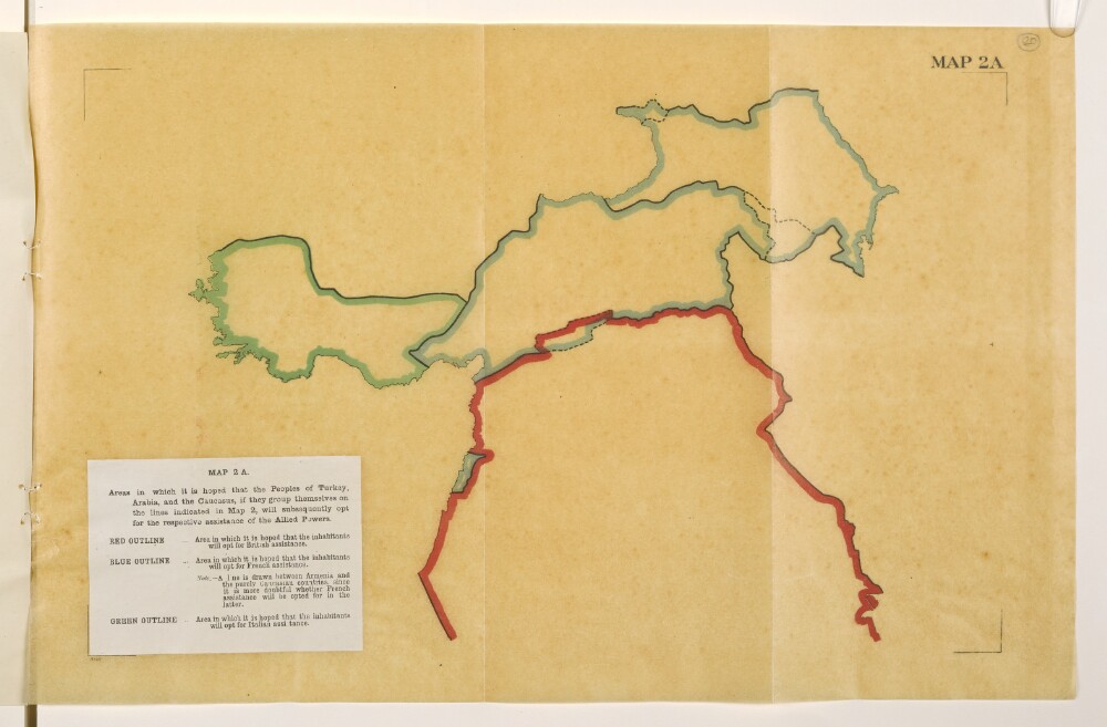
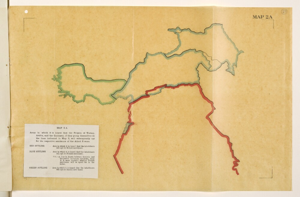
Abstract: Map is an overlay to Mss Eur F112/570, f 21 and forms a part of Mss Eur F112/570, ff 17-23.The title and legend are printed on a small paper sheet that has been pasted over the south-west corner of the map. Map portrays, by variously coloured boundaries, areas in which it is 'hoped that the inhabitants will opt for [British, French or Italian] assistance'. Bears the imprint '8146.' [Published by the Political Intelligence Department, Foreign Office, 21 November 1918.]Another copy of this map is at Mss Eur F112/570, f 27.Physical description: Materials: Printed in colour on tracing paperDimensions: 243 x 393mm, on sheet 290 x 450mm
Abstract: Map is an overlay to Mss Eur F112/570, f 28 and forms a part of Mss Eur F112/570, ff 24-30.The title and legend are printed on a small paper sheet that has been pasted over the south-west corner of the map. Map portrays, by variously coloured boundaries, areas in which it is 'hoped that the inhabitants will opt for [British, French or Italian] assistance'. Bears the imprint '8146.' [Published by the Political Intelligence Department, Foreign Office, 21 November 1918.]Another copy of this map is at Mss Eur F112/570, f 20.Physical description: Materials: Printed in colour on tracing paperDimensions: 243 x 393mm, on sheet 290 x 450mm
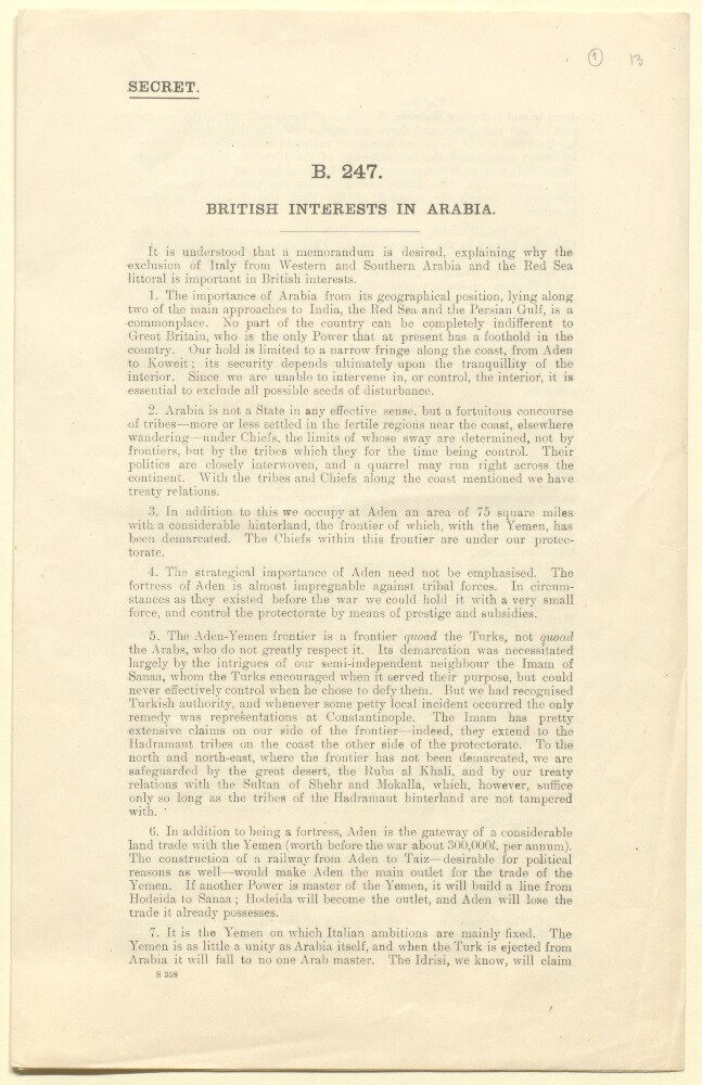
Abstract: This memorandum was written by Sir Frederic Arthur Hirtzel in January 1917. Its purpose is to explain 'why the exclusion of Italy from Western and Southern Arabia and the Red Sea littoral is important in British interests'. It notes the importance of Arabia lying as it does along two of the main approaches to India from Europe. Hirtzel's memorandum also notes the absence of an effective state in Arabia, and the concomitant influence of tribes and their chiefs.It reviews the strategic importance of Aden and its protectorate along with the significance of the Aden-Yemen frontier in the context of British relations with the Imam of Sanaa and Turkey (paragraphs 4-5). It notes that the Italian ambitions are mainly focused on the Yemen and that the Italo-Turkish war made Italy the most unpopular 'Christian power' in the Muslim world. It analyses the implications of any British consent to an Italian occupation of the Yemen.It concludes that the 'present war has shown the use that may be made against us of Islam' and contends that the success of H M Government in the Middle East 'depends to a large extent on the transfer of the Caliphate from Turkey to Arabia. This in turn depends on the possibility of making the ruler of the Hejaz sufficiently strong to be able to pose as an independent sovereign. This again depends upon keeping the Christian powers at a sufficient distance.' The memorandum finishes by noting that it was for these reasons Britain took the precaution of inserting in the Anglo-French convention [Sykes-Picot agreement] that the British and French Governments agree that they will not themselves acquire and will not consent to a third Power acquiring territorial possessions in the Arabian peninsula with a sphere of influence being seen as equivalent to territorial possession.Physical description: Foliation: The foliation sequence commences at the first folio and terminates at the last folio; these numbers are written in pencil, are circled, and are located in the top right corner of the recto side of each folio. Pagination: The booklet also has an original printed pagination sequence.
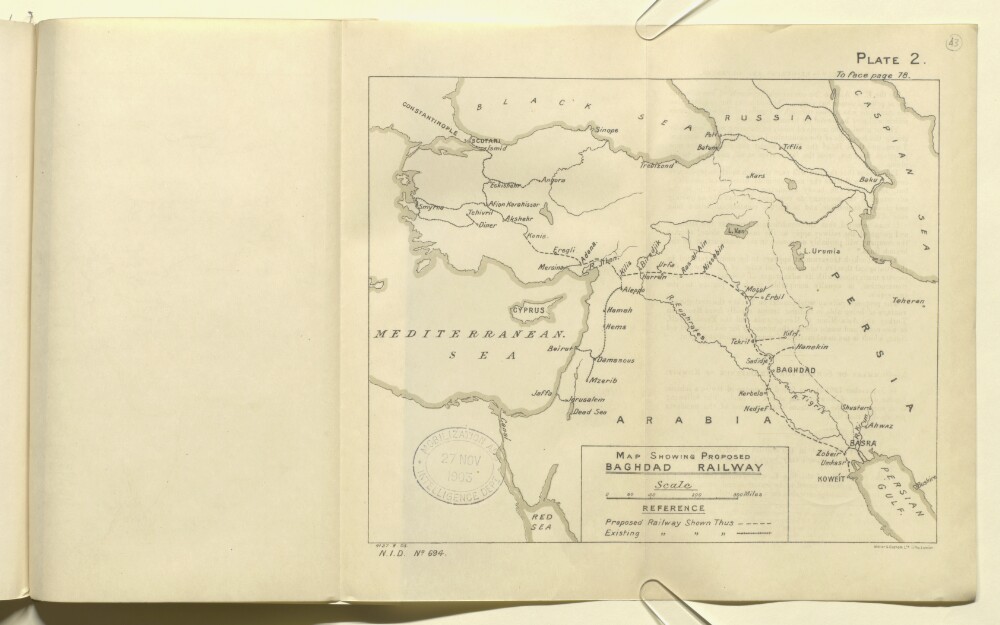
Abstract: The map shows a region encompassing parts of Russia, Persia, Arabia and the Ottoman Empire, indicating the routes of proposed and existing railway lines. The map also shows hydrology, topography and major cities and towns.The map is Plate 2 in 'Persian Gulf and Gulf of Oman' (Naval Intelligence Department No. 694), 1903, and bears the printing statement, 'Weller & Graham, Ltd. Litho, London.'.Physical description: Materials: Printed on paperDimensions: 196 x 240mm, on sheet 244 x 405mm
Abstract: Imprint:Photozincographed at the Office of the Trigonometrical Brach, Survey of India, Dehra Dún, C. Dyson, photo; C. G. Ollenbach Zinco.Distinctive Features:Relief shown by hachures.Shows route of the submarine telegraph cable laid in 1864 and 1867.Includes a note with details on the sources used in compilation of the map and a table listing chief tribes and provinces of Nejd.Physical description: Dimensions:470 x 950 mm
Abstract: The file consists of a note, dated 10 January 1918, written by John Evelyn Shuckburgh (Political Department, India Office) on a memorandum written by Sir Mark Sykes on the Palestine and West Arabian situation. The note was prepared for a meeting of the Middle East Committee. Shuckburgh comments on statements made by Sykes, and provides an account of the latest developments and plans for the region. A section is included on policy in regards to Bin Saud [Abd al-‘Azīz bin ‘Abd al-Raḥmān bin Fayṣal Āl Sa‘ūd ] (Wahabi Emir of Nejd), and tensions with King Husain [Hussein bin Ali] (Sharif and Emir of Mecca). Recommendations for action are given.Physical description: Foliation: the foliation sequence for this description commences at f 28, and terminates at f 30, as it is part of a larger physical volume; these numbers are written in pencil, are circled, and are located in the top right corner of the recto side of each folio. An additional foliation sequence is present in parallel between ff 28-30; these numbers are also written in pencil, but are not circled.
Abstract: The volume is a fifth edition of a collection of historic treaties, engagements and sanads (charters) signed between representatives of the British Government or East India Company, and foreign rulers, dignitories or government officials, in the regions of Aden, south west Arabia, the Arab coast of the Persian Gulf, including Muscat and Oman, Baluchistan, and the north-west frontier province (present-day Pakistan). This volume, originally compiled by Charles Umpherston Aitchison, Under Secretary to the Government of India in the Foreign Department, was revised in 1930 and published in 1933 by the Manager of Publications in Dehli, under the authority of the Government of India.Part 1 contains treaties and engagements relating to Aden and the southwest coast of Arabia:An historical overview of British (and Turkish) involvement in the region, including descriptions of the treaties and engagements signed;The Anglo-Turkish Convention (in French) respecting the boundaries of Aden, dated 9 March 1914;Treaties and conventions, agreed between the years 1802-1917, at Aden and with the Abdali tribe, the Subeihi, Fadhli, Aqrabi, Aulaqi, Irqa, Lower Haura, Beihan, Yafai, Audhali, Haushabi, Alawi, the Amirate of Dhala, the Wahidi, Kathiri, the Sultanate of Mukalla, Soqotra [Suquṭrā] and Qishn, Yemen, and the Idrisi. The treaties cover agreements of commerce, friendship and protection; agreements for the cession or purchase of land, for the abolition of the slave trade, storage of coal, protection of shipwrecked British sailors.Part 2 contains treaties and engagements relating to the Arab principalities of the Persian Gulf, divided into the following areas: 1) The Wahhābī and Nejd [Najd]; 2) Bahrain; 3) The Trucial Arab shaikhs (of Oman); and 4) Kuwait:An historic overview of the agreements made between the British and the region’s rulers, organised by tribes and/or geographical locality;Agreements and treaties signed with the Wahhābī tribe, including: an agreement between the Wahhābī and British Government over aggression towards the Arab tribes, dated 21 April 1866; a series of conventions and treaties agreed in the 1920s, establishing boundaries and relations between the Kingdom of Najd and its neighbours; the Treaty of Jeddah, dated 20 May 1927;Agreements and treaties signed with the ruler of Bahrain, relating to: piracy and slavery (1820), abstention from entering into relations with foreign powers (1880, 1892), arms trafficking, wireless telegraphy (1912), and oil exploitation (1914);Agreements and treaties signed with the shaikhs of the Arab coast, relating to respect for British property (1806), piracy (1820), the slave trade (1838, 1873), the maintenance of maritime peace in perpetuity (1853), the Anglo-Qatar treaty (1916); oil exploitation (1922);Agreement and treaties signed with the ruler of Kuwait, relating to: arms trafficking, exclusive post office rights (1904), pearling and sponge fishing concessions (1911), wireless telegraphy (1912), oil exploitation (1913), boundaries between Kuwait and Najd (1922) and Kuwait and Iraq (1923).Part 3 contains treaties and engagements relating to Oman, chiefly Muscat but also Sohar:An historical overview of the Sultanate of Muscat, and the agreements made between Britain and Muscat;Treaties and conventions, agreed between the years 1798 and 1929, including: the exclusion of the French from the Sultan of Muscat’s territories (1798); suppression of the slave trade (1822, 1873); commerce (1839); cession of the Kuria Muria islands [Jazā'ir Khurīyā Murīyā] (1854); the independence of Zanzibar (1861, 1862); telegraphic communications (1864, 1865); jurisdiction of Indian subjects at Muscat (1873); friendship and commerce (1891); coalfields at Ṣūr (1902); arms traffic (1919); prolongation of the commercial treaty (1891); treaty of peace between the Sultan of Muscat and Chief of Sohar (1839).Part 4 contains treaties and engagements relating to Baluchistan:An historic overview of the region and its districts, including British involvement in Baluchistan, organised by the Kalat [Kelat] Agency, Sibi Agency, and British Baluchistan and its territories;The treaties and conventions listed for Kelat, agreed between the years 1839 and 1925, include: an engagement between the British Government and the Khan of Kelat (1839), the Khan of Kelat’s allegiance and submission to the British Government (1841); various agreements for the protection of the Indo-European telegraph line; cession of lands for the Kandahar Railway (1880), Mushkaf-Bolan Railway (1894) and Nushki Railway (1906); demarcation of the boundary between Persian Baluchistan and Kelat (1896);The treaties and conventions listed for Sibi and British Baluchistan, agreed between the years 1884 and 1897, including: cession to the British Government of rights to petroleum and other mineral oils (1885); agreement on the Bargha and Largha boundary line (1895), grazing fees for animals and responsibility for good behaviour within the British border at Zhob, signed by the Suliman Khel Ghilzai (1897).Part 5 contains treaties and engagements relating to the northwest frontier province:An historic overview of British involvement and administration of the province;The treaties and conventions agreed in the province, arranged as follows : 1) Hazara District; 2) Dir, Swat and Chitral Agency; 3) Peshawar District; 4) Khyber Agency; 5) Kohat District; 6) Kurram Agency; 7) Bannu District; 8) North Waziristan Agency; South Waziristan Agency. The agreements relate to: relations with the British; maintenance of peace; acceptance of terms; protection of borders and communications; commerce; exclusion or expulsion from certain districts of undesirables, including ‘Hindustani fanatics’.The appendices contain a number of treaties signed between foreign rulers, including treaties agreed between Muscat and the United States, French and Dutch Governments, as well as British Parliament acts and memoranda related to the treaties and engagements in the volume.Physical description: Foliation: The volume’s foliation sequence uses circled pencil numbers, located in the top-right corner of the recto of each folio. It begins on the first folio with text, on number 1, and ends on the last folio with text, on number 405. Total number of folios: 405. Total number of folios including covers and flysheets: 409.Pagination: The volume has a series of printed pagination sequences, expressed in Roman numerals for the contents, appendices and index pages, and in Arabic numerals for the volume’s main content matter. These numbers are located in the top-left corner of versos and the top-right corner of rectos.
Abstract: Map of the south-eastern part of the Arabian Peninsula, showing the boundaries of the Aden Protectorate and various proposed lines for the boundaries of south-eastern Arabia and Qatar. In addition to boundaries the map indicates hydrology and tribal areas, and provides some indication of relief. A key of reference indicates some of the boundaries and features. A note in the bottom right-hand corner states that the map was drawn by Sapper R Bunyan. The scale is given as 1 inch to 32 miles.Physical description: Materials: Manuscript on paper.Dimensions: 828 x 1016mm, on sheet 850 x 1040mm.
Abstract: Enclosures no. 2-7 to a despatch from the Secret Department, Government of Bombay, dated 27 August 1844. The enclosures are dated 17 July-27 August 1844.The enclosures consist of correspondence relating to a ‘Memoir on the South and East Coasts of Arabia’, written by the Political Agent, Aden, and accompanying nautical chart. The memoir and chart themselves are not included in the item.The correspondents are the Political Agent and the Government of India.Physical description: 1 item (10 folios)
Abstract: The file contains a historical memorandum written in response to claims advanced by Ibn Saud to ancestral rights on the eastern boundary of the Saudi Kingdom, and to suggestions put forward by him that at some period in the past arrangements were entered into with his ancestors, the Wahabi Amirs, by representatives of the British Government, which afforded some recognition of those claims. The memorandum was written by John Gilbert Laithwaite, India Office, and is a revised edition of a document published on 1 September 1934.Physical description: Foliation - the main foliation sequence (used for referencing) commences at the front cover with 1 and terminates at the inside back cover with 32; these numbers are written in pencil, are circled, and are located at the top right corner of the recto side of each folio.Pagination: the file also contains an original printed pagination sequence.