« Previous |
1 - 12 of 19
|
Next »
Number of results to display per page
Search Results
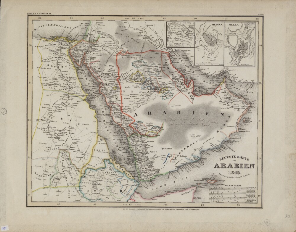
1. Newest Map of Arabia
- Description:
- Abstract: This color map in German appeared as plate 80 in Grosser Hand-Atlas über alle Theile der Erde (Large portable atlas of all parts of the world), published by the Bibliographic Institute of Joseph Meyer (1796−1856). The map shows the Arabian Peninsula as well as neighboring parts of Africa, including Egypt, present-day Sudan, and Abyssinia (present-day Ethiopia). Colored lines are used to demarcate kingdoms and other political entities. El Bedaa, an old city in Qatar (now the Al Bida area of Doha), is shown. Three inset maps in the upper right hand corner show the cities of El Derreyeh (Ad Dir‘īyah), Mekka (Mecca), and Medina. An unusual feature of the map is the large number of distance scales provided, which reflects both the thoroughness of the mapmaker and the lack of international standardization at the time. They include geographic miles, English miles, French leagues, Dutch miles, Spanish leagues, Portuguese leagues, Italian miles, Danish miles, Swedish miles, Russian versts, Greek miles, and nautical miles. Meyer was a successful German businessman who founded the Bibliographic Institute as a publishing house in 1826. The firm specialized in producing low-cost editions of the classics, atlases, encyclopedias, and other books for purchase by the general public.Physical description: 1 map ; 35 x 29 centimeters
2. The Nabhani Offering on the History of the Arabian Peninsula
- Description:
- Abstract: Al-Tuḥfat al-Nabhānīya fī tārīkh al-jazīra al-ʻArabīya (The Nabhani offering on the history of the Arabian Peninsula) is by Muḥammad ibn Kahlīfa ibn Ḥamd ibn Mūsā al-Nabhānī (1883 or 1884−1950 or 1951). The author was a teacher at the Masjid al-Ḥarām in Mecca (as was his father). The younger al-Nabhani started this work after his visit to Bahrain, and a request that he write a book treating the history of the current rulers of Bahrain, as well of its ancient emirs and their dealings with friend and foe. As the original plan had been to limit the work to the history of Bahrain, al-Nabhānī initially titled his work al-Nubdha al-laṭīfa fī al-ḥukkam min al-khalīfa (The charming fragment regarding the rulers of the house of al-Khalīfa). When the work was expanded to include the totality of the Arabian Peninsula, its name changed as well. Chapter nine of this work is a large section (with independently numbered pages) on Basra (present-day Iraq), in which al-Nabhani served briefly as judge, and in which he was imprisoned by the British during World War I. The present copy is a revised and expanded second edition, published in 1923−24 at the Maṭbaʻat al-maḥmūdīya publishing house in Cairo.Physical description: 3 volumes in 1 book ; 21 centimeters
3. Chapter Nine of the Book of Medicine Dedicated to Mansur, with the Commentary of Sillanus de Nigris
- Description:
- Abstract: Abu Bakr Muhammad Ibn Zakariya al-Razi (also known by Latinized versions of his name, Rhazes or Rasis, 865–925 AD) was a Persian polymath, physician, and philosopher. He was born in Rayy, south of present-day Tehran, Iran. After studying philosophy, at around the age of 30 he began studying medicine under the supervision of Abu Al-Hassan al-Tabari. He became the head of a Rayy hospital and later headed a hospital in Baghdad. Al-Razi was known in the fields of medicine and chemistry, which he combined to prescribe medications for numerous ailments. The author of 200 books and commentaries in various fields of knowledge, al-Razi was the first to use surgical threads and wrote an important treatise on smallpox and measles. Al-Razi’s Kitab al-Mansouri (Book of medicine dedicated to Mansur), a short, general textbook on medicine in ten chapters, was translated into Latin and became one of the most widely read medieval medical manuals in Europe. The ninth chapter, on therapeutics, frequently circulated by itself under the title Liber nonus ad Almansorem (Chapter nine of the book of medicine dedicated to Mansur). Numerous editions of the book were printed in Renaissance Europe, with commentaries by prominent physicians of the day. This 1483 edition was printed in Venice by Bernardus Stagninus (flourished circa 1483–1536). It includes a commentary by Sillanus de Nigris and an essay by Petrus de Tussignano (Pietro da Tossignano), eminent physicians who were active around 1400.Physical description: 280 items
4. Commentary on the Mysteries of Revelation, the Perfection of Locution, and Comprehensive Interpretation
- Description:
- Abstract: Al-Kashshāf (Commentary) is among the most widely known tafsirs (explications or exegeses) of the Qurʼan. Written in 12th-century Persia by Mahmud ibn ʻUmar Zamakhshari, it remains the object of study and debate among exegetes, who argue against its Mu’tazilite rationalism, even as they recognize its deep learning and linguistic sophistication. The work is taught, if not admired, by all the Sunni and Shia schools of interpretation. Modern scholar Kifayat Ullah states that “no other work in the history of tafsir has been commented on in the forms of glosses, superglosses, supercommentaries, and mukhtasars [abridgements] more than al-Kashshaf.” The breadth and complexity of the arguments are summarized in the book’s subtitle: “On the mysteries of revelation, the perfection of locution, and comprehensive interpretation [of the Qurʼan].” Mu'tazilism’s rational approach to the nature of God and scripture passed from the mainstream of Muslim thought in much of the Islamic world, but it survived in the area of Khurasan (also seen as Khorasan), Iran, the home of Zamakhshari. The author’s challenge to orthodox philosophy, combined with his undisputed mastery of Arabic grammar and philology and his extensive travel to promote his ideas, provided the foundation for the enduring legacy of his tafsir. The work was printed in two volumes in 1864 at the Bulaq Press in Cairo, at the time under the administration of ‘Abd al-Rahman Rushdi and under the scholarly direction of Shaykh Muhammad Qutb al-‘Adawi. The work was edited by Muhammad al-Sabbagh, who may be the author of the notes in the margin of the main text. There is a biographical and critical afterward in rhymed prose, including panegyric poetry and the text of the inscription on the author’s grave in eastern Iran.Physical description: 482 pages ; 28 centimeters
5. The Greater Luminary
- Description:
- Abstract: This volume contains Luminare Maius (The greater luminary), and an antidotarium (book of antidotes), by Joannes Jacobus de Manliis (1490). It is based on the works of the Nestorian Persian physician Yūḥannā Ibn Māsawayh (circa 777–857), known in the Latin West as Mesue, and “other distinguished physicians.” Also included is an edition of Pandectarum Medicinae (Encyclopedia of medicaments) by Matteo Silvatico (also known by his Latinized name, Mattheus Sylvaticus, circa 1280–circa 1342), which consists of an alphabetized list of medications, primarily of herbal origin. Sylvaticus relied and expanded on the work of Simon of Genoa (flourished end of 13th century), who provided a lexicon of Latin, Greek, and Arabic medical terms in his dictionary, Clavis Sanationis. Sylvaticus also drew on the works of earlier Greco-Roman authorities, such as Dioscorides, Galen, and Paul of Aegina (circa seventh century). Other important sources were scientists in the Islamic world, such as the Persian physicians Ibn Sīnā (known as Avicenna in the Latin West, circa 980–1037) and Rāzī (Rhazes in the Latin West, circa 865–circa 925), and the Andalusian scientist Ibn Rushd (Averroes in the Latin West, 1126–98). For each of the 702 entries in this work, Sylvaticus provides the Arabic and Greek names, in addition to information about the medicinal properties of the material or plant in question. As in his Clavis Sanationis, for each letter of the Latin alphabet, a short introduction provides notes on transliteration from the Greek and Arabic into Latin. This edition was commissioned by Octavianus Scotus of Modena and produced in Venice in 1498 by the printer Bonetus Locatellus (active 1486–1523). It is not the earliest extant printing of this work. Other early printings include those from Naples (1474), Vicenza (1480), and Venice (1480, 1492, and 1499). Sandwiched between Luminare Maius and the Pandectarum Medicinae is a short work, Lumen Apothecarium, also by Manliis, which consists primarily of a table of contents for Luminare Maius.Physical description: 253 pages : illustrations ; 30 centimeters
6. Defending the Qurʼan Against Slander
- Description:
- Abstract: Tanzīh al-Qurʼān ʻan al-maṭāʻin (Defending the Qurʼan against slander) is a detailed commentary on the Qurʼan from the viewpoint of the early philosophical wing of Islamic speculative theology known as Mu’tazilah, which emphasized the oneness of the Godhead (Allah) and the primacy of human reason in understanding his will. This view gave rise to intense debate, with alternate views expressed by the rationalist Asharites and mystical adepts (Sufis). In Islamic intellectual history, philosophical speculation of this sort is termed ‘ilm al-kalam (science of discourse). As with many such abstract arguments, the debate spilled over into politics and even bloodshed. Eventually, the theological views of Abu al-Hasan al-Asha’ari (died circa 935) prevailed as the basis of Sunni scholastic theology, and the Mu’tazilite school disappeared from the mainstream. The author of the main work in this volume, ‘Abd al-Jabbar al-Asadabadi (circa 937−1025), was a prominent figure in Mu’tazilism and Tanzīh al-Qurʼan has an important place in its history. ‘Abd al-Jabbar addresses issues of faith and morality in light of what he describes as the inherently rational injunctions of the Qurʼan. Questions and answers are arranged according to the suras (chapters) of the Qurʼan. Topics include marriage, gambling, drinking alcohol, death, and jihad. The author responds to questions by arguing that, whatever the injunction, God has created what is best for mankind and the believer is free to choose the right path. Abu al-Hasan ʻAbd al-Jabbar ibn Ahmad ibn ʻAbd al-Jabbar al-Hamadhani (the full name of ‘Abd al-Jabbar’, who was nicknamed Qadhi al-Qudhat, meaning the Judge of the Judges) was born in Asadabad in present-day Iran. He was a prolific author and the leader of the Mu'tazilites of his time. His erudition was sought at court in Baghdad. He eventually moved to the Iranian provincial capital Rayy (Rey or Ray), where he died. His magnum opus is the al-Mughni (Summa), a compendium of Mu’tazilah thought. Tanzih al-Qurʼan is followed by a 20-page treatise attributed to judge-exegete Raghib al-Isfahani (died 1108), entitled Muqaddimat al-tafsir (Introduction to Qurʼan commentary), which appears to be a précis of his other, longer works on the subject. It has no connection to the main work of the volume. The book was printed in 1911 at the Jamaliyah Press in Cairo and was financed by Muhammad Saʿid al-Rafiʿ, owner of the Azhariyah Bookstore.Physical description: 432 pages ; 20 centimeters
7. Refinement of Character
- Description:
- Abstract: Tahdhib al-akhlaq (Refinement of character) is a guide to practical conduct by the famous Iranian polymath Ibn Miskawayh (died 1030). It is considered a primary contribution to the field of ethics. Its origins are firmly rooted in Greek philosophy rather than in Islamic texts and traditions. In his philosophical writings, Ibn Miskawayh presents rational rather than scriptural arguments. Often associated by scholars with Neo-Platonist methods, the author makes frequent reference to Aristotle in discussing human nature, requirements for happiness, and the virtuous life. Ibn Miskawayh is sometimes categorized with Shia medieval philosophers, but he is universally heralded throughout the Muslim world, as exemplified by this rendering of the work by Egyptian editor ‘Abd al-‘Alim Salih, who dedicates the work to Ottoman sultan ‘Abd al-Hamid II and to Egyptian ruler ‘Abbas Hilmi Basha (1874−1944). The edition also includes a preface by a prominent jurist of al-Azhar, a further testament to the widespread appeal of Ibn Miskawayh’s writings in the Islamic world. The work was published in Cairo at al-Taraqqi Press. It is not a critical edition of the original. Rather, it gives the appearance of being a private endeavor, perhaps published to win favor at the Egyptian court. Ibn Miskawayh (also seen as Ibn Miskawah or Ibn Meskavayh) was a person of many accomplishments -- a librarian, court official, associate of princes, historian, physician, and philosopher. He was the correspondent or intellectual companion of many of the great thinkers of his time, such as Abu Hayyan al-Tawhidi (died 1023). Depending on the vicissitudes of politics or career opportunities, he lived in Abbasid Baghdad and at other times at courts in Persian cities. Tahdhib al-akhlaq is also known by its subtitle Tathir al-‘irq (Purity of disposition). Ibn Miskawayh’s historical and philosophical writings have received much attention from modern scholars.Physical description: 187 pages ; 25 centimeters
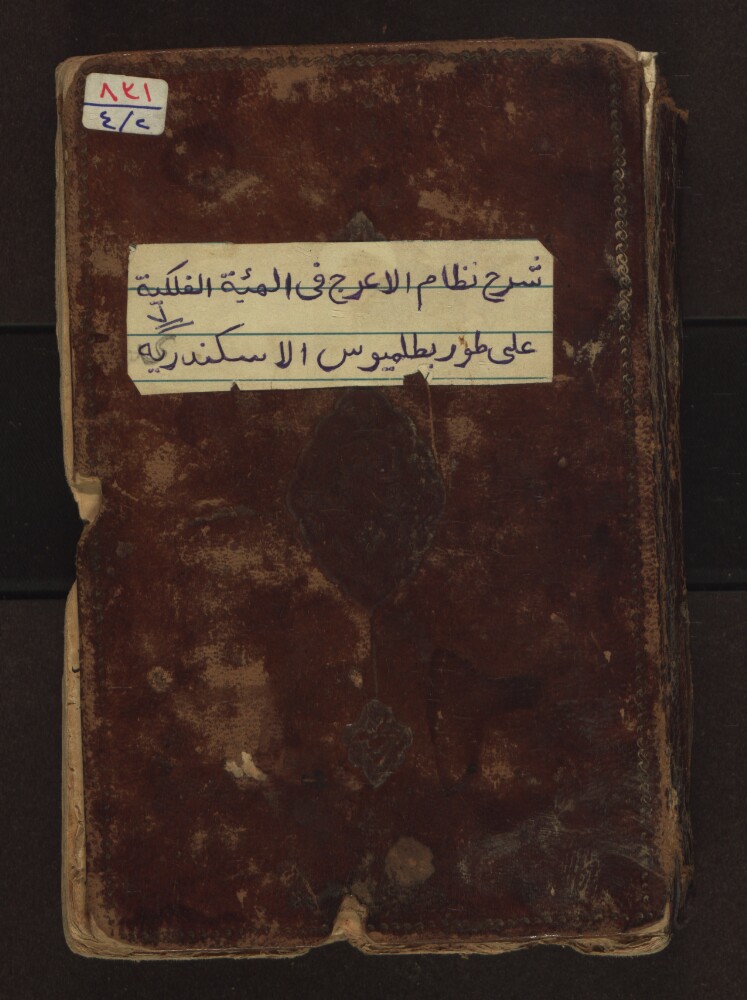
8. The Elucidation of the Memoir on Astronomy by Ṭūsi
- Description:
- Abstract: This manuscript is a commentary on Naṣīr al-Dīn Muḥammad ibn Muḥammad Ṭūsi's al-Tadhkira fī al-‘ilm al-hay’a (Memoir on astronomy). Written in the second half of the 13th century, Ṭūsi's work was hugely influential for subsequent generations of astronomers in the Islamic world, and several of the commentaries on it became popular in their own right. This commentary is by Niẓām al-Dīn Ḥasan b. Muḥammad al-A‘raj al-Nīsābūrī al-Qummī (died after 1311). In the introduction to his work, which the author himself entitles Tauḍīḥ al-Tadhkira (Elucidation of the Memoir), al-Nīsābūrī praises Ṭūsi's work as possessing a wealth of riches, including the most important thoughts of the moderns and a summary of the views of the ancients. He adds that in writing his commentary, he undertook to include the entire text of Ṭūsi's work, and that the figures in the original text would be rendered in black, whereas those of the commentary would be drawn in red in order to make it possible to “distinguish the [individual] viewpoints.” Al-Nīsābūrī could trace his intellectual lineage to Ṭūsi via his own teacher, Maḥmūd ibn Masʻūd Quṭb al-Shīrazī (1226–1311), who is often cited as the most outstanding student of Ṭūsi. In addition to this work, al-Nīsābūrī wrote commentaries on Ṭūsi's Taḥrīr al‐Majisṭī (Recension of the Almagest), his Sī faṣl dar ma‘rifat-i taqwīm (Thirty chapters on the science of the calendar), and his Zīj-i Ilkhāni (The Īlkhānid astronomical handbook). The colophon of the present manuscript lists the date of completion as the first day of Rabī‘ al-awwal of the year 711 AH (July 18, 1311), which was shortly after the death of Quṭb al-Shīrazī. Scholars have claimed that Tauḍīḥ al-Tadhkira Tauḍīḥ was the most important text at Ulugh Beg's madrasah in Samarkand for the study of al-Tadhkira fī al-‘ilm al-hay’a.Physical description: (Number of lines: 19) : drawings ; 19 x 13.5 centimeters
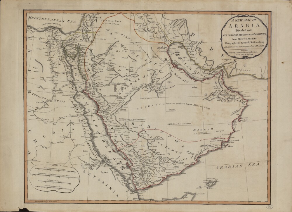
9. A New Map of Arabia: Divided into Its Several Regions and Districts
- Description:
- Abstract: This map of Arabia, published in London in 1794, is an English translation of a map by the French cartographer and geographer Jean-Baptiste Bourguignon d’Anville (1697−1782). Appointed the first geographer to the king of France in 1773, d’Anville was one of the most important mapmakers of the 18th century, known for the accuracy and scientific quality of his maps. The work presented here is said to contain “Additions and Improvements from Mr. Niebuhr,” a reference to Carsten Niebuhr (1733–1815), a German-born Danish explorer and civil engineer who journeyed through Arabia and Yemen in 1762–67 and whose Travels through Arabia and Other Countries in the East (an abridged translation from the original German) was published in Edinburgh in 1792. The map includes cities and towns, coastlines, caravan routes to Mecca, wells, mines, and other geographic features, and brief notations on some of the peoples and kingdoms of the Arabian Peninsula. Qatar is shown as “Catura,” with the notation “Coast little Known” just south of its location. Four distance scales are given: great Arabian miles, great parasangs or Persian leagues, sea leagues, and British miles. The map was published by the London firm of Laurie & Whittle, a partnership of the engraver Robert Laurie (circa 1755−1836) and print seller James Whittle (1757−1818) that was known for its accurate maps and nautical charts.Physical description: 1 map ; 46.5 x 59 centimeters

10. Colton's Persia, Arabia, Et cetera
- Description:
- Abstract: This map showing the Arabian Peninsula, Persia (present-day Iran), Afghanistan, and Baluchistan (present-day Iran and Pakistan) was published in 1855 by the G.W. and C.B. Colton and Company of New York. Coloring is used to indicate borders and certain provinces or settled areas. The map shows cities, mountains, and roads, and includes some notes on topographical features. The old Qatari city of Al Zabara is shown. The map is accompanied by a one-page summary of the geography, people, principal places, and recent history of Afghanistan and Baluchistan. The map later appeared in the 1865 edition of Colton’s General Atlas and reflects the general level of geographic knowledge of the Middle East in mid-19th-century America. J.H. Colton & Company was founded in New York City, most likely in 1831, by Joseph Hutchins Colton (1800–93), a Massachusetts native who had only a basic education and little or no formal training in geography or cartography. Colton built the firm into a major publisher of maps and atlases by purchasing the copyrights to and republishing other maps before it began creating its own maps and atlases. In the 1850s, the firm became the G.W. & C.B. Colton Company, after Colton brought his sons, George Woolworth Colton (1827–1901) and Charles B. Colton (1832–1916), into the business. As in this example, virtually all Colton maps were framed in decorative borders of intertwining vines, flowers, or geometric shapes.Physical description: 1 map : color ; 31 x 36 centimeters
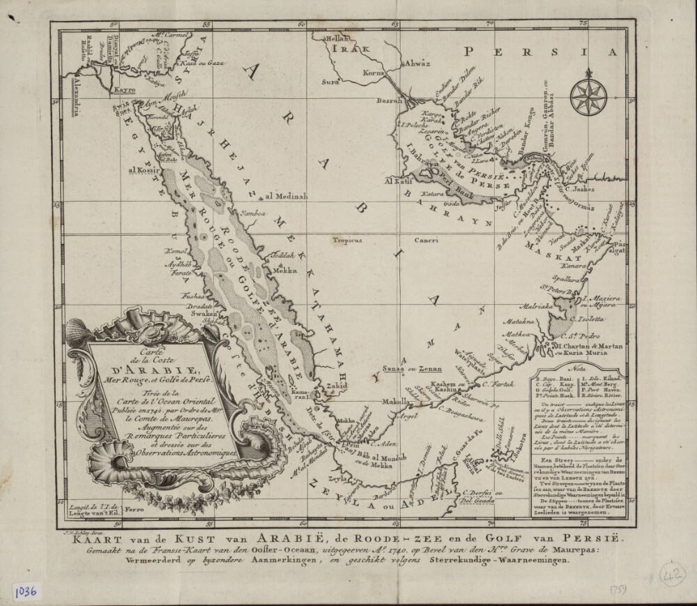
11. Map of the Arabian Coast, Red Sea, and Persian Gulf
- Description:
- Abstract: This map of the coastlines of the Arabian Peninsula and adjacent regions is by the French hydrographer and cartographer Jacques-Nicolas Bellin (1703−72). Bellin was attached to the French Marine Office for more than 50 years and specialized in producing maritime maps. He also made most of the maps for Histoire générale des voyages: ou, Nouvelle collection de toutes les relations de voyages par mer et par terre, qui ont été publiées jusqu'à présent dans les différentes langues de toutes les nations connues (General history of the voyages, or, a new collection of all the accounts of voyages on sea and on land, which have been published up to the present in the different languages of all known countries), a 15-volume compendium edited by Abbé Antoine-François Prévost (1697–1763) and published between 1746 and 1759. This map appeared in the first volume of this work. The map shows coastlines, ports, and coastal shoals. At a time when the determination of location was still an inexact science, a note at upper right explains the use of three different symbols on the map: a star to indicate places where location had been determined by astronomical observations of latitude and longitude; a cross to indicate places where location had been determined by astronomical observations of (only) latitude; and a modified cross to indicate places where location had been determined by latitudinal observations made by skilled navigators.Physical description: 1 map ; 22 x 25 centimeters
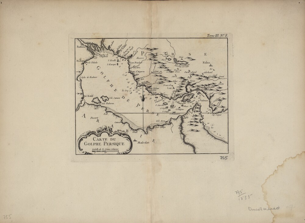
12. Map of the Persian Gulf
- Description:
- Abstract: This map of the Persian Gulf is by the French cartographer Jacques-Nicolas Bellin (1703−72). Qatar is shown as Catura. Cities on both the Arabian and Persian sides of the gulf are indicated, and the map shows a river emptying into the gulf at the port of Julfar (present-day Ra's al-Khaymah, United Arab Emirates). The scale is in common leagues, and there are no latitudinal or longitudinal lines. Trained as a hydrographer, Bellin was attached to the French Marine Office and specialized in producing maritime maps showing coastlines. His maps were in the tradition of Nicolas Sanson (1600–1667), the royal geographer to Kings Louis XIII and Louis XIV commonly known as the father of French cartography, and of Guillaume de l'Isle (1675−1726), one of a group of French cartographers that wrested mapmaking preeminence from the Dutch in the late 17th century. Like Sanson and de l’Isle, Bellin placed great emphasis on scientific accuracy rather than on artistic beauty for its own sake. In 1764, he published Le Petit Atlas Maritime: Recueil de Cartes et de Plans des Quatre Parties du Monde (Small maritime atlas: collection of maps and charts of the four parts of the world), a work in five volumes containing 581 maps. This map appeared as plate 8 in volume 3 of this work, containing maps of Asia (part I) and Africa (part II).Physical description: 1 map : copper engraving ; 22 x 17 centimeters
- « Previous
- Next »
- 1 Current Page, Page 1
- 2