1 - 7 of 7
Number of results to display per page
Search Results
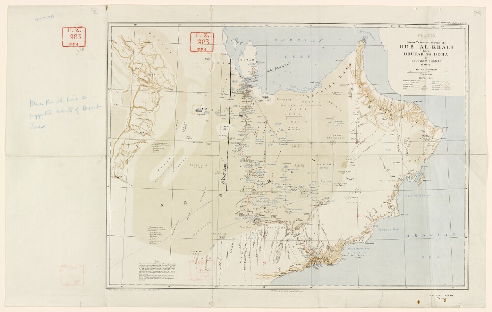
1. 'ARABIA. Route Traverse across the RUB' AL KHALI from DHUFAR TO DOHA by BERTRAM THOMAS 1930-31'
- Description:
- Abstract: Map published by the Royal Geographical Society. From the Geographical Journal, September 1931.The map depicts Bertram Thomas's 1930-31 route, and earlier routes, in red. The map indicates settlements, hydrology, and also provides some indication of relief. Also included is a table of reference for symbols used on the map.The map includes two additional lines: a line in black ink marked 'blue line' (a boundary line that formed part of the non-ratified Anglo-Ottoman Convention of 1913, and was redefined and adopted in the Anglo-Ottoman Convention of the following year), and a line in pencil outlining the suggested limits of a 'desert zone', which was considered by the British as a possible territorial concession to Saudi Arabia.Another edition of this map can be found at IOR/R/15/2/159, f 246.Physical description: Materials: Printed in colour on paper, with manuscript additions in black ink and pencil.Dimensions: 440 x 540mm, on sheet 458 x 722mm.
2. 'File 38/15 Oil concessions in Arabia and the Gulf (Muscat)'
- Description:
- Abstract: The file contains correspondence relating to the oil concession in Muscat, Oman, and Dhofar. The principal correspondents are: the Political Resident at Bushire (later Bahrain) [Persian Gulf Political Residency]; the Political Agent at Bahrain; the Political Agent at Kuwait; the Political Agent at Muscat; the India Office; the Foreign Office, Sultan Said bin Taimur [Sa‘īd ibn Taymūr Āl Sa‘īd], the ruler of Muscat and Oman; and representatives of Petroleum Concessions Limited and its subsidiary, Petroleum Development (Trucial Coast) Limited.Matters covered by the file include: the ambition of Petroleum Development Concessions for the concession over Rub al-Khali, the desert region that spans the territories of Oman and Saudi Arabia;Standard Oil's interest in the Muscat concession;Lermitte's visit to Muscat in the summer of 1937 to discuss the agreement with the Sultan;the suspension of oil operations during the Second World War;the company's attempts to extend the period within which they have the option to drill by 2-5 years;company plans to begin exploration in Oman during the winter of 1947/48;and Richard Bird's dealings with the Al Bu Shamis tribe in Buraimi in March 1948.Folios 3-7 is a memorandum produced by the Petroleum Department (of the British Government) giving an overview of the current situation regarding oil concessions in Arabia and the Persian Gulf.Folios 9-19 is the record of a meeting between representatives from the Colonial Office, Foreign Office, India Office, Admiralty, Petroleum Department, and Indian Political Service, held at the Colonial Office on 3 May 1933. The meeting covers similar topics to that of the memorandum above.Folios 107-111 are internal office notes.Physical description: Foliation: the main foliation sequence (used for referencing) commences at the front cover and terminates at the back cover; these numbers are written in pencil, are circled, and are located in the top right corner of the recto side of each folio. An additional foliation sequence is also present in parallel between ff 2-91; these numbers are also written in pencil, but are not circled, and are located in the same position as the main sequence. A previous foliation sequence, which is also circled, has been superseded and therefore crossed out.
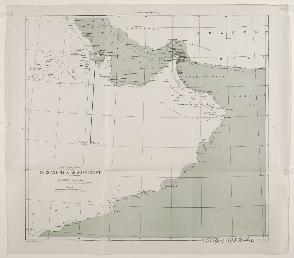
3. 'SKETCH MAP OF THE PERSIAN GULF & ARABIAN COAST'
- Description:
- Abstract: Map issued as Annex no. 5A to the Anglo-Ottoman Convention of 29 July 1913, with roads and overland and submarine telegraph lines shown. A blue line runs from Jazirat az Zakhnūnīyah to the centre of Ruba'-al-Khaila [Rubʻ al Khālī]. The map contains notations concerning topographic features.The signatures of Sir Edward Grey and Ibrahim Hakki Pasha appear within the border, at the bottom right-hand corner.Other editions of this map can be found at IOR/R/15/1/613, f 126 and IOR/R/15/1/741, f 8.Physical description: Materials: Printed on paper.Dimensions: 443 x 477mm, on sheet 493 x 557mm.
4. ‘WILFRED THESIGER’
- Description:
- Abstract: This file concerns the movements of Wilfred Thesiger at the end of his second crossing of the Empty Quarter [al-Rub‘ al-Khālī]. Correspondence in the file is between the Political Officer, Sharjah; the Political Agent, Bahrain; the Political Resident, Bahrain; the Political Agent, Muscat; the Residency Agent, Sharjah; G W Furlonge and B A B Burrows, Foreign Office, London; and Richard ('Dick') Bird, representative of Petroleum Development Oman.Details concern Thesiger’s arrival in Abu Dhabi on 16 March 1948 and his intention to proceed to Buraimi [al-Buraymī]; the preference of the Sultan of Muscat for Thesiger not to visit Muscat and the cancellation of his visa to enter the Sultanate of Oman; Thesiger's intention to collect plants and animal specimens at Buraimi and to travel from Abu Dhabi to Bahrain by dhow; Bird's desire that Thesiger should not proceed anywhere south of the village of Hafit [Ḥafīt]; Thesiger's legal status during his travels and restrictions on his movements; the retention of Thesiger's Bedouin and their raid on Bani Qitab; his arrival in Bahrain; requests by Thesiger for ammunition; concerns that he was responsible for raiding in Saudi Arabian territory; and his nickname 'Mubarak bin London'.The file also includes summaries of intelligence gathered from Thesiger (ff 38, 42) and Bird's letter regarding Thesiger's presence in Buraimi (ff 54-55).Physical description: Foliation: the main foliation sequence (used for referencing) commences at the front cover with 1, and terminates at the inside back cover with 64; these numbers are written in pencil, are circled, and are located in the top right corner of the recto side of each folio. An additional foliation sequence is present in parallel between ff 1-61; these numbers are also written in pencil, but are not circled, and are located in the same position as the main sequence.
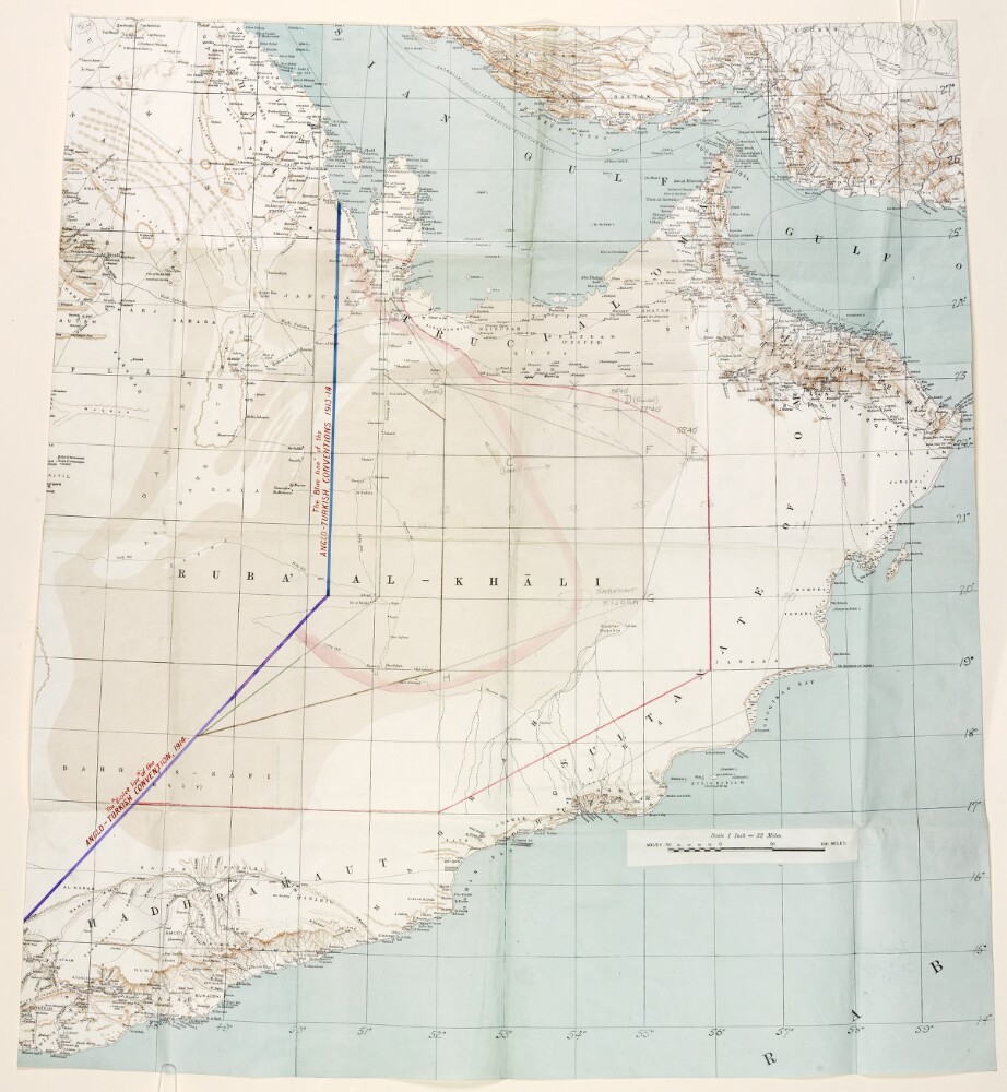
5. Map of the Ruba'-al-Khali
- Description:
- Abstract: Map depicting the Ruba'-al-Khali and the surrounding region. The map indicates settlements, hydrology, and boundaries and provides some indication of relief. The map features additional lines marked in coloured ink, crayon, and pencil, which represent possible boundary lines for eastern and south-eastern Saudi Arabia.Two joined lines in blue and violet ink represent boundaries established in the Anglo-Ottoman Conventions of 1913 and 1914. Lines in green and brown crayon represent boundary lines proposed by the British to Ibn Saud [‘Abd al-‘Azīz bin ‘Abd al-Raḥmān bin Fayṣal Āl Sa‘ūd]. A line in red crayon marks Ibn Saud's reported interpretation of his country's eastern and south-eastern boundary, and lines in pencil show other prospective boundaries considered by the British Government.Physical description: Materials: Printed in colour on paper, with manuscript additions in coloured ink, pencil, and crayon.Dimensions: 795 x 710mm.
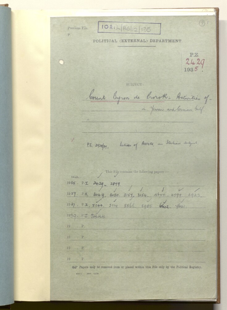
6. PZ 2429/1935 'Count Byron de Prorok: activities in Yemen and Persian Gulf'
- Description:
- Abstract: The file comprises telegrams, despatches, correspondence, memoranda, and notes, relating to the monitoring by British officials of the activities of Count Byron Khun de Prorok and his expeditions in Yemen and the Persian Gulf. This included attempts to search for the ancient lost city of Ubar in the Rubʻ al Khālī and the fabled capital city of the Queen of Sheba.The discussion in the file relates to the correspondence with scientific institutes (Royal Geographical Society; Royal Anthropological Institute) concerning de Prorok's scientific credentials, nationality, name and title. Also discussed is the refusal of the Sultan of Muscat to allow an expedition to proceed from Muscat and the British refusal to allow a start from Sharjah. Also discussed are British concerns about motivations for the expedition and connections with Italian oil interests.Included in the file is a handwritten letter from Prorok to the India Office (folio 32) and an advertisement for an evening lecture at the Pump House, Bath (folio 10).The file contains correspondence between: the Passport Control Department, Foreign Office, London; the Political Resident in the Persian Gulf; and the India Office, London.Physical description: Foliation: the foliation sequence for this description (used for referencing) commences at f 7, and terminates at f 68, as it is part of a larger physical volume; these numbers are written in pencil, are circled, and are located in the top right corner of the recto side of each folio. An additional foliation sequence is present in parallel; these numbers are also written in pencil, but are not circled.
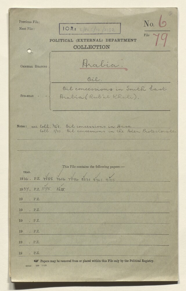
7. Coll 6/79 'Oil: Oil concessions in South East Arabia (Rub'al Khali).'
- Description:
- Abstract: This file relates to oil concessions in south-eastern Saudi Arabia. Much of the correspondence discusses British concerns regarding the possibility of oil being discovered in the Ruba' al Khali [Rubʻ al Khālī], and the bearing that such a discovery might have on the question of the eastern and south-eastern frontiers of Saudi Arabia. Also discussed are the prospect of Petroleum Concessions Limited securing an oil concession for territory in the Ruba' al Khali, and the extent of the territory covered in the concession secured by the Standard Oil Company of California in 1933.The file features the following principal correspondents: His Majesty's Minister at Jedda (Sir Reader William Bullard); Major Stephen Hemsley Longrigg of Petroleum Concessions Limited; officials of the Foreign Office, the India Office and the Admiralty.The file includes a divider which gives a list of correspondence references contained in the file by year. This is placed at the back of the correspondence.Physical description: Foliation: the foliation sequence (used for referencing) commences at the front cover with 1, and terminates at the inside back cover with 40; these numbers are written in pencil, are circled, and are located in the top right corner of the recto side of each folio.