« Previous |
1 - 12 of 15
|
Next »
Number of results to display per page
Search Results
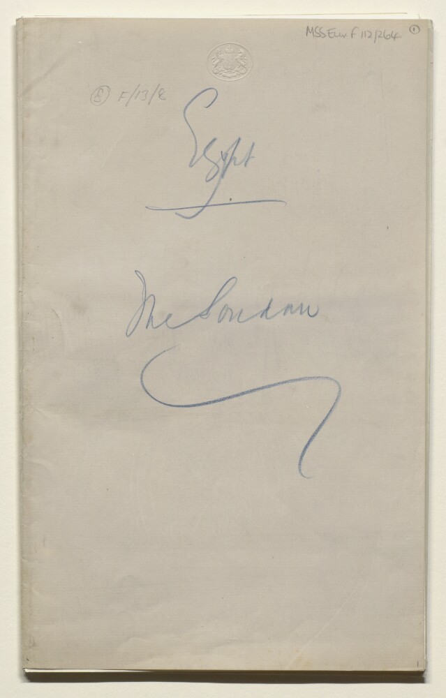
1. 'Egypt: The Soudan'
- Description:
- Abstract: The file contains printed copies of correspondence, memoranda, and a periodical concerning Egypt and the Sudan (often written as Soudan). The papers relate to the negotiations between Britain and Egypt over the status of Sudan following the end of the British Protectorate in Egypt. They include memoranda by Foreign Office officials, correspondence between Field Marshall Edmund Henry Hynman Allenby (the High Commissioner in Cairo), and Lord Curzon, and copies of The Near Eastwhich feature articles on Egypt and Sudan (folios 15-17).Physical description: Foliation: the main foliation sequence (used for referencing) commences at the front cover with 1, and terminates at the inside back cover with 18; these numbers are written in pencil, are circled, and are located in the top right corner of the recto side of each folio. An additional foliation sequence is present in parallel between ff 1-18; these numbers are also written in pencil, but are not circled.Pagination: the file also contains an original printed pagination sequence.
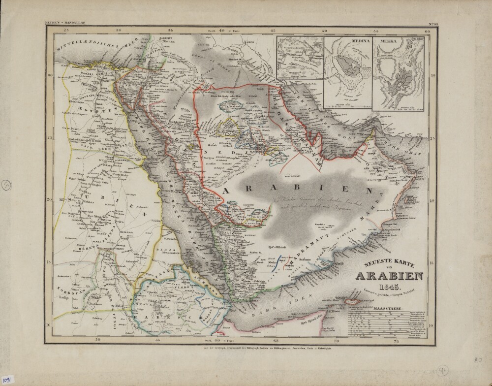
2. Newest Map of Arabia
- Description:
- Abstract: This color map in German appeared as plate 80 in Grosser Hand-Atlas über alle Theile der Erde (Large portable atlas of all parts of the world), published by the Bibliographic Institute of Joseph Meyer (1796−1856). The map shows the Arabian Peninsula as well as neighboring parts of Africa, including Egypt, present-day Sudan, and Abyssinia (present-day Ethiopia). Colored lines are used to demarcate kingdoms and other political entities. El Bedaa, an old city in Qatar (now the Al Bida area of Doha), is shown. Three inset maps in the upper right hand corner show the cities of El Derreyeh (Ad Dir‘īyah), Mekka (Mecca), and Medina. An unusual feature of the map is the large number of distance scales provided, which reflects both the thoroughness of the mapmaker and the lack of international standardization at the time. They include geographic miles, English miles, French leagues, Dutch miles, Spanish leagues, Portuguese leagues, Italian miles, Danish miles, Swedish miles, Russian versts, Greek miles, and nautical miles. Meyer was a successful German businessman who founded the Bibliographic Institute as a publishing house in 1826. The firm specialized in producing low-cost editions of the classics, atlases, encyclopedias, and other books for purchase by the general public.Physical description: 1 map ; 35 x 29 centimeters
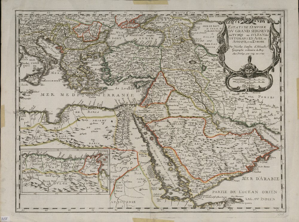
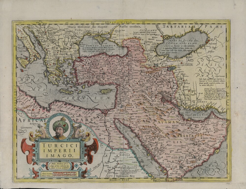
3. Lands of the Emperor of the Turks or the Ottoman Sultan in Asia, Africa, and Europe
- Description:
- Abstract: This map shows the Ottoman Empire as it was conceived in Europe in the last quarter of the 17th century. It is a reprint, dated 1679, of an earlier edition possibly included in a series of world atlases published by Nicolas Sanson (1600−1667) in the middle of the century. The map shows geological features, such as rivers, deserts, and mountain ranges. Cities and towns are indicated, and colored lines are used to mark the borders of kingdoms. An inset map at the lower left shows the extension of the southern coast of the Mediterranean, westward to Algeria. Place-names are in French. Sanson is considered by many to be the founder of the French school of cartography. Originally from Abbeville, he was also known as Sanson d’Abbeville. He was trained as a military engineer but became a prolific cartographer who produced more than 300 maps. Around 1643, he began publishing maps, working with publisher Pierre Mariette. In the period from the 16th to the 18th centuries, French, British, and Dutch mapmakers competed to supply the growing demand for maps of the East as European commerce expanded in regions beyond the Mediterranean. Sanson was among the early cartographer-publishers to profit from this demand. He established a dynasty of geographers and mapmakers that endured for a century.Physical description: 1 map : hand colored ; 39.2 x 54.5 centimeters

4. Arabia: According To Its Modern Divisions
- Description:
- Abstract: “Arabia According to Its Modern Divisions” shows the Arabian Peninsula with the three-part division traditionally used in European sources into Arabia Petraea, Arabia Deserta, and Arabia Felix. Deserts, seaports, and the pearl beds along the coast are indicated. Qatar is shown as Catura. Four different distance scales—Arabian miles, Turkish miles, Persian parasangs, and British miles—are provided. Published in 1794, the map was compiled and drawn by Samuel Dunn (circa 1723−94), a teacher of mathematics and navigation who made original contributions to solving the problem of determining longitude. In addition to making maps, Dunn wrote a number of books on mathematics and navigation, including The Description and Use of the Universal Planispheres (1759) and The Theory and Practice of the Longitude at Sea (1778). This map was published by the firm of Laurie & Whittle, a partnership of the engraver Robert Laurie (circa 1755−1836) and print seller James Whittle (1757−1818) that was known for its accurate maps and nautical charts.Physical description: 1 map ; 47 x 59 centimeters
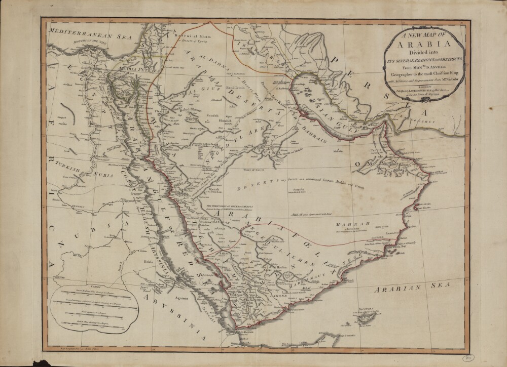
5. A New Map of Arabia: Divided into Its Several Regions and Districts
- Description:
- Abstract: This map of Arabia, published in London in 1794, is an English translation of a map by the French cartographer and geographer Jean-Baptiste Bourguignon d’Anville (1697−1782). Appointed the first geographer to the king of France in 1773, d’Anville was one of the most important mapmakers of the 18th century, known for the accuracy and scientific quality of his maps. The work presented here is said to contain “Additions and Improvements from Mr. Niebuhr,” a reference to Carsten Niebuhr (1733–1815), a German-born Danish explorer and civil engineer who journeyed through Arabia and Yemen in 1762–67 and whose Travels through Arabia and Other Countries in the East (an abridged translation from the original German) was published in Edinburgh in 1792. The map includes cities and towns, coastlines, caravan routes to Mecca, wells, mines, and other geographic features, and brief notations on some of the peoples and kingdoms of the Arabian Peninsula. Qatar is shown as “Catura,” with the notation “Coast little Known” just south of its location. Four distance scales are given: great Arabian miles, great parasangs or Persian leagues, sea leagues, and British miles. The map was published by the London firm of Laurie & Whittle, a partnership of the engraver Robert Laurie (circa 1755−1836) and print seller James Whittle (1757−1818) that was known for its accurate maps and nautical charts.Physical description: 1 map ; 46.5 x 59 centimeters
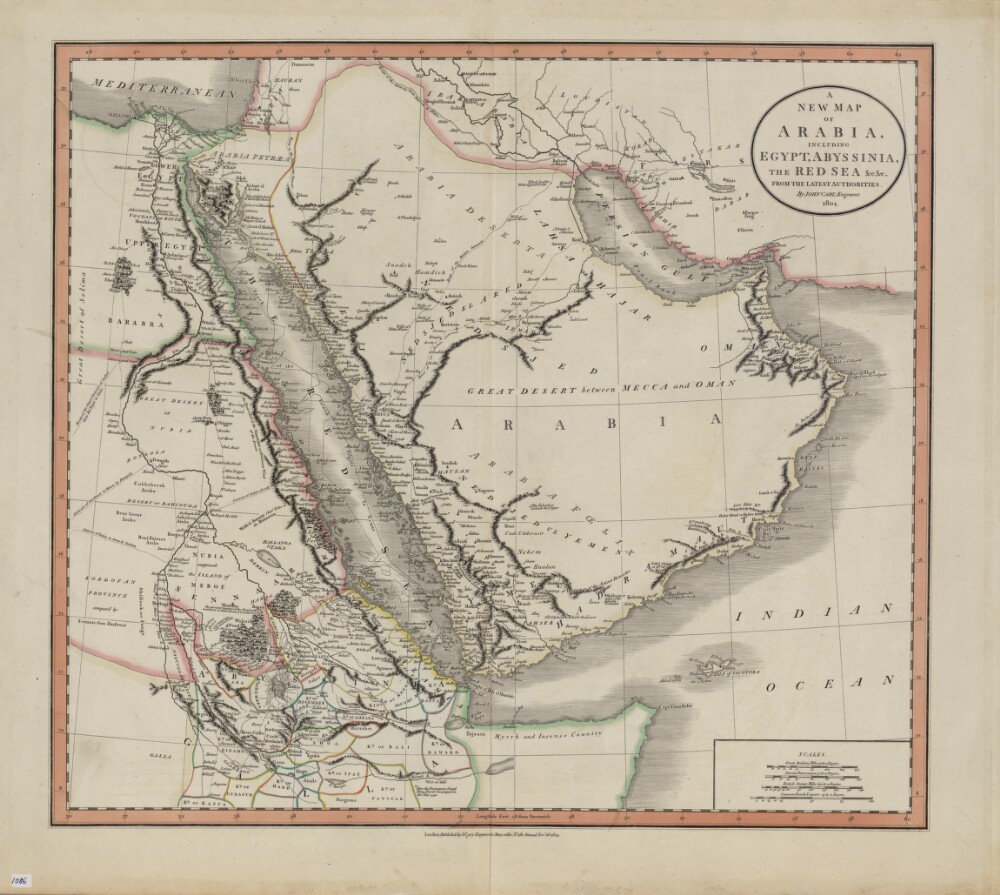
6. A New Map of Arabia, Including Egypt, Abyssinia, the Red Sea, from the Latest Authorities
- Description:
- Abstract: John Cary (circa 1754−1835) was a leading London engraver, map-, chart- and print-seller, and globe maker, active between 1787 and 1834. This map of 1804 shows the Arabian Peninsula and neighboring parts of Africa and the Middle East. Important caravan routes are marked, including the “route of the grand caravan of Sudan from the Niger to Cairo,” “route of the caravan from Batsora [Basra] to Aleppo,” “caravan of Darfowar [Darfur] to Mecca by Dongola,” “caravan of Sudan directly to Mecca by Suakem,” and several other caravan routes to Mecca. Many African kingdoms are shown, their borders marked with colored lines, as is a speculative source of the Nile. The northern coast of Somalia is called “Myrrh and Incense Country.” The zigzag line in the Red Sea indicates the course of La Venus, a French frigate that sailed on a voyage of discovery in the Red Sea, Persian Gulf, and Indian Ocean in 1785−88. The map includes many other notes that reflect the state of European geographic understanding of this region at the beginning of the 19th century. Four distance scales are given: great Arabian miles, Persian parasangs, British statute miles, and common French leagues.Physical description: 1 map : hand colored ; 44 x 50 centimeters
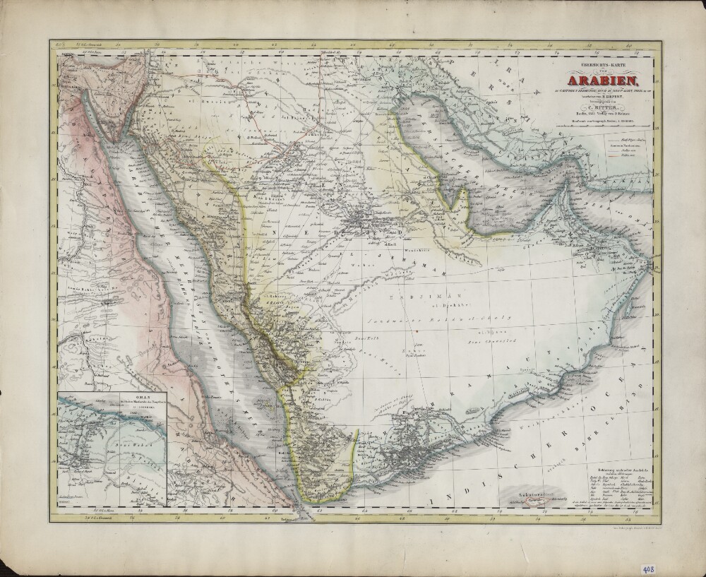
7. Overview Map of Arabia. Based on C. Ritter's Geography Book III, West Asia, Parts XII−XIII
- Description:
- Abstract: German geographer and cartographer Heinrich Kiepert (1818–99) is generally regarded as one of the most important scholarly cartographers of the second half of the 19th century. He was head of the Geographical Institute in Weimar between 1845 and 1852 and professor at the University of Berlin from 1852 until his death. Shown here is Kiepert’s 1852 map of Arabia. As indicated in the title, it is based on “C. Ritter’s geography book.” The latter refers to Die Erdkunde im Verhältnis zur Natur und zur Geschichte des Menschen (Geography in relationship to nature and to the history of humanity), the pioneering 23-volume work of scientific geography published between 1822 and 1859 by the German geographer Carl Georg Ritter (1779−1859). The map contains a wealth of geographic and historical information, including pilgrimage (hajj) routes, the routes in northern Arabia of the explorers George Forster Sadlier (1819) and Georg August Wallin (1848), and explanations in German of Arabic geographic expressions, with abbreviations. At the lower left is an inset map of Oman, which provides much detail, including the routes taken by French naturalist Pierre-Martin-Rémi Aucher-Eloy and East India Company naval officer James Raymond Wellsted. The map was lithographed by the firm of Heinrich Mahlmann (1812−48) and published by Dietrich Reimer, with whom Kiepert had a long association.Physical description: 1 map : lithograph ; 47 x 36 centimeters
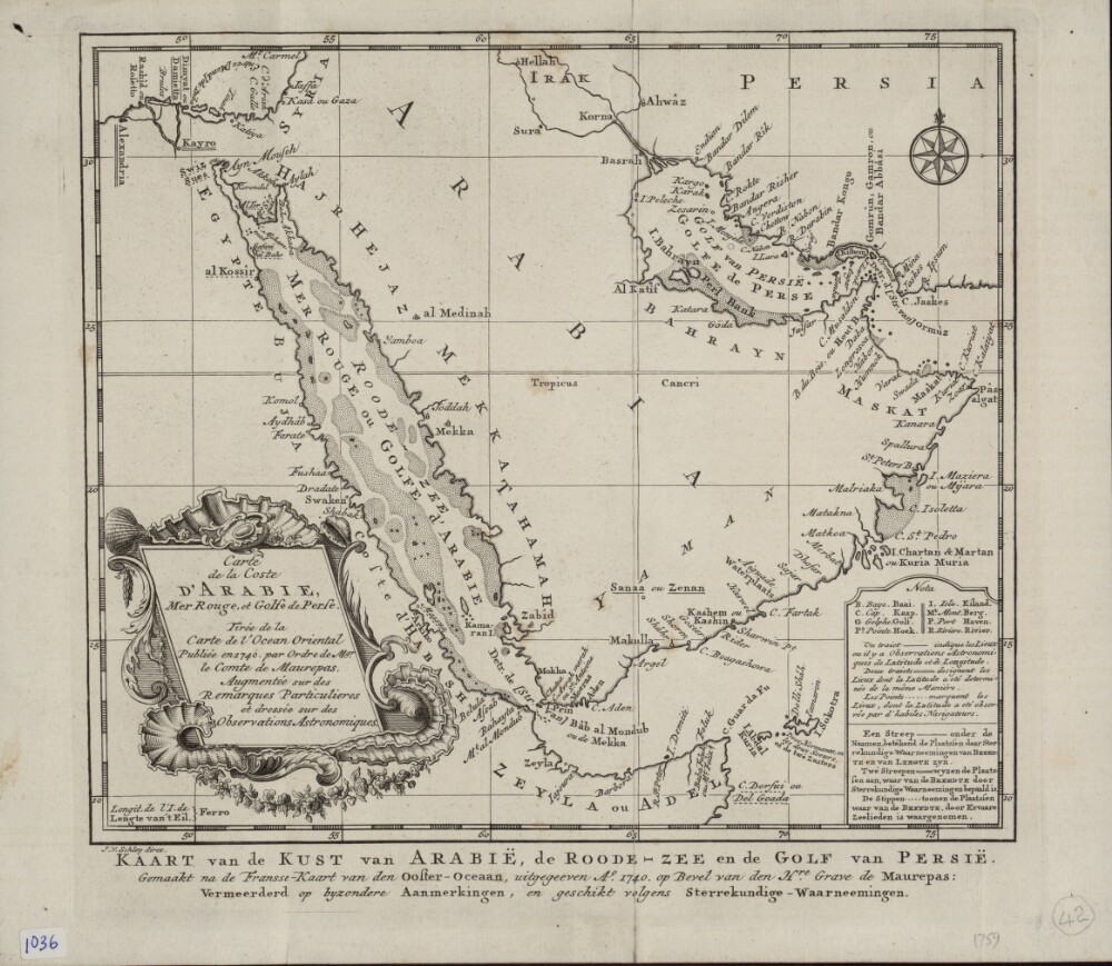
8. Map of the Arabian Coast, Red Sea, and Persian Gulf
- Description:
- Abstract: This map of the coastlines of the Arabian Peninsula and adjacent regions is by the French hydrographer and cartographer Jacques-Nicolas Bellin (1703−72). Bellin was attached to the French Marine Office for more than 50 years and specialized in producing maritime maps. He also made most of the maps for Histoire générale des voyages: ou, Nouvelle collection de toutes les relations de voyages par mer et par terre, qui ont été publiées jusqu'à présent dans les différentes langues de toutes les nations connues (General history of the voyages, or, a new collection of all the accounts of voyages on sea and on land, which have been published up to the present in the different languages of all known countries), a 15-volume compendium edited by Abbé Antoine-François Prévost (1697–1763) and published between 1746 and 1759. This map appeared in the first volume of this work. The map shows coastlines, ports, and coastal shoals. At a time when the determination of location was still an inexact science, a note at upper right explains the use of three different symbols on the map: a star to indicate places where location had been determined by astronomical observations of latitude and longitude; a cross to indicate places where location had been determined by astronomical observations of (only) latitude; and a modified cross to indicate places where location had been determined by latitudinal observations made by skilled navigators.Physical description: 1 map ; 22 x 25 centimeters
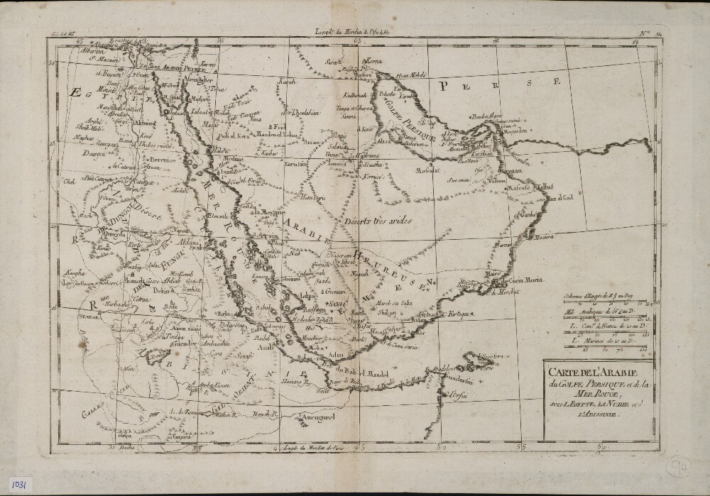
9. Map of Arabia, the Persian Gulf, and the Red Sea; Including Egypt, Nubia, and Abyssinia
- Description:
- Abstract: This map of the Arabian Peninsula and surrounding areas was most likely created by the French cartographer and hydrologist Rigobert Bonne (1727−94). It is probably a proof copy of the map of the same title published in his Atlas des toutes les parties connues du globe terrestre (Atlas of all known land surfaces of the globe). The Arabian Peninsula is the main focus of the map, but it also covers much of the Nile Valley on the western shore of the Red Sea. The atlas was created to serve the global commercial and political interests of European traders and officials. Rigobert Bonne was one of many outstanding French cartographers of the 18th century. Self-taught in mathematics, he rose in the French administration to become chief hydrologist of the state Maritime Department. As a theoretician, he published a revision of global cartographic projection entitled Principes sur les mesures en longueur et en capacité (Principles of measurement of length and volume), a copy of which he sent to Thomas Jefferson in 1790 for discussion at the American Philosophical Society.Physical description: 1 map ; 21 x 31 centimeters
10. Map of the Turkish Empire
- Description:
- Abstract: This map shows the Ottoman Empire as it appeared in the early 17th century. It details Ottoman territories in Asia, Africa, and Europe, and includes Persia, Transcaucasia, Ethiopia, and other surrounding lands. Topographic features, place-names, and populations are definitively marked, although the nomenclature of the time differs markedly from that used today. The Red Sea is termed the Sea of Mecca, for example, and the Persian Gulf is called the Sea of Alcatif. The map sometimes has been identified as a part of Atlas sive Cosmographicae Meditationes de Fabrica Mundi et Fabricati figura (Atlas of the world: finely engraved and drawn), produced by Jodocus Hondius following the work of Gerard Mercator. There is no evidence on the map itself to sustain that identification, nor is a date of publication supplied. Ottoman lands are hand-colored in red, except for the European territories. The vivid coloring is not contemporary with the production of the map and was probably added in the 19th century after Greece and the Balkan lands, which are not colored, were freed from Ottoman rule. Different lettering denotes different geographic and ethnographic features. Italics are generously used, and geometric shapes and shading are used to indicate mountain ranges and maritime littorals. The title cartouche indicates that Hondius, the supposed creator, based his map on Mercator’s projection. The cartouche itself is of interest for its cameo portrait entitled “Sultan Mahumet Turcorum Imperat” (Sultan Muhammad Emperor of the Turks), probably meant to represent Sultan Mehmed II (1432−81), known as Mehmed the Conqueror.Physical description: 1 map : hand colored ; 34 x 47 centimeters
11. PZ 5636/35 'Egypt: Annual Reports 1934 -1938'
- Description:
- Abstract: The volume comprises five printed Foreign Office annual reports (for the years 1934, 1935, 1936, 1937, 1938) relating to Egypt.The printed reports follow the same format. They start with a letter from the High Commissioner to Egypt (Sir Miles Lampson) to the Secretary of State for Foreign Affairs (Sir John Simon, Anthony Eden, Viscount Halifax) with a summary of significant developments.Accompanying these letters is an enclosure with the annual report for each year. Each report starts with a contents section. The reports have an introduction and sections on internal politics and relations with the United Kingdom and the British Empire; international relations by country; relations between Egypt and the Sudan; economic and financial situation; and general matters.Physical description: Foliation: the foliation sequence (used for referencing) commences at the inside front cover with 1, and terminates at the inside back cover with 168; these numbers are written in pencil, are circled, and are located in the top right corner of the recto side of each folio. An additional foliation sequence is present in parallel between ff 5-165 ; these numbers are also written in pencil, but are not circled.
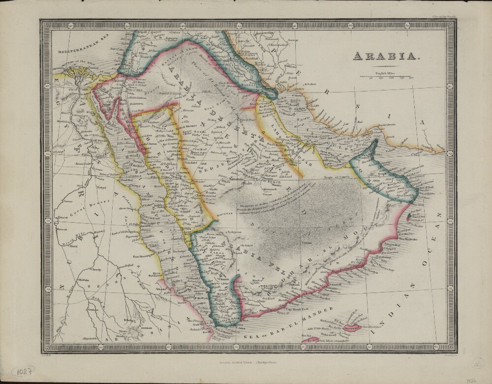
12. Arabia
- Description:
- Abstract: This map of the Arabian Peninsula appeared in the 1856 edition of the world atlas that was first published by James Wyld (1790−1836) in 1824 and in successive editions by his son, James Wyld the younger (1812−87). Political divisions are indicated by colored lines and the scale is in English miles. Cities, towns, wells, and caravan routes to Mecca are shown. An annotation on the map reflects the limited state of European knowledge about geography of parts of the peninsula: “The interior of Arabia is probably a high plain inclining towards the Persian Gulf; a great proportion of it is occupied by extensive Deserts, occasionally seperated [sic] by small mountainous Oases.” After studying at the Royal Military Academy at Woolwich, James Wyld the younger joined his father’s mapmaking and publishing firm, which he eventually inherited. Wyld published numerous maps, many of which were intended to satisfy public interest in current events, such as the First Anglo-Afghan War, the California Gold Rush, and the Crimean War. Wyld’s maps were of high quality, and he was appointed geographer to Queen Victoria and Prince Albert.Physical description: 1 map ; 21 x 26 centimeters
- « Previous
- Next »
- 1 Current Page, Page 1
- 2