Number of results to display per page
Search Results
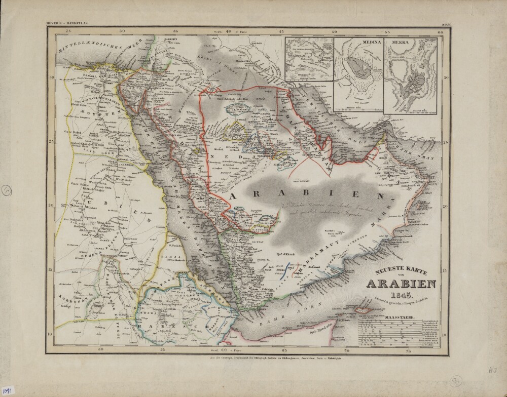
37. Newest Map of Arabia
- Description:
- Abstract: This color map in German appeared as plate 80 in Grosser Hand-Atlas über alle Theile der Erde (Large portable atlas of all parts of the world), published by the Bibliographic Institute of Joseph Meyer (1796−1856). The map shows the Arabian Peninsula as well as neighboring parts of Africa, including Egypt, present-day Sudan, and Abyssinia (present-day Ethiopia). Colored lines are used to demarcate kingdoms and other political entities. El Bedaa, an old city in Qatar (now the Al Bida area of Doha), is shown. Three inset maps in the upper right hand corner show the cities of El Derreyeh (Ad Dir‘īyah), Mekka (Mecca), and Medina. An unusual feature of the map is the large number of distance scales provided, which reflects both the thoroughness of the mapmaker and the lack of international standardization at the time. They include geographic miles, English miles, French leagues, Dutch miles, Spanish leagues, Portuguese leagues, Italian miles, Danish miles, Swedish miles, Russian versts, Greek miles, and nautical miles. Meyer was a successful German businessman who founded the Bibliographic Institute as a publishing house in 1826. The firm specialized in producing low-cost editions of the classics, atlases, encyclopedias, and other books for purchase by the general public.Physical description: 1 map ; 35 x 29 centimeters
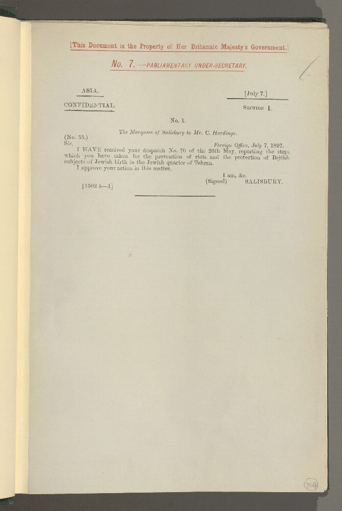
38. Foreign Office Papers: Persia
- Description:
- Abstract: This item comprises printed Foreign Office correspondence relating to Persia [Iran], covering geopolitical, political, economic, social and cultural matters. The despatches are dated 7 July 1897-22 September 1898.The first page of each despatch includes the heading ‘ASIA. CONFIDENTIAL.’ on the top left, and the day and month of the despatch in square brackets on the top right e.g. ‘[July 7.]’. The letters in each despatch are numbered, e.g. No. 1, followed, where relevant, by numbered enclosures (spelled ‘inclosure’ in the volume), e.g. ‘Inclosure in No. 1.’ or ‘Inclosure 1 in No. 2.’. A few of the letters from Charles Hardinge, First Secretary, Tehran, to Persian Government ministers are in French.The item notably covers and includes:The financial difficulties of the Persian Government including: negotiations for foreign loans to the Persian Government, notably a proposed loan of forty million francs by Messrs Solomon Oppenheim of Paris and Cologne on the security of the customs revenues of the southern ports of Persia, and proposed Russian loans (including a copy of a draft agreement, in French, presented to the Persian Government by the Russian Legation, ff 375-376); and loans negotiated with the Imperial Bank of Persia, notably a loan of fifty-thousand pounds secured by control of the customs revenue of Bushire [Bushehr] and KermanshahAffairs relating to the Persian Mint and its relations with the Imperial Bank of PersiaThe murder of Mr Graves, a commissioned officer of the Indo-European Telegraph Department, at Karwan in southern Persia, the indemnity demanded from the Persian Government by the British Government, measures taken for the arrest and punishment of the murderers, and arrangements for the future protection of the telegraph line and company employeesFactionalism, internecine strife, and changes in personnel within the Persian Government and Cabinet, including the dismissal of the Sadr-i-Azam [Ṣadr A‘ẓam, Prime Minister] in June 1898The assassination of Sheikh Mizal [Shaikh Miz’al Khān], Governor of Muhammerah [Khorramshahr, formerly Mohammerah], and recognition of Sheikh Khazal [Shaikh Khas’al bin Jābir bin Mirdāw al-Ka’bī, also spelled Khasal in this item] as the new GovernorAn attack on Koweit [Kuwait] by the Persian Sheikh Yussuf Ibrahim [Shaikh Yūsuf Ibrāhīm]The state of affairs in Azerbaijan and TabrizThe state of affairs in Persian Beluchistan [Balochistan]Rumours of a raid by members of the Shahsavend [Shahsavan] tribe into Russian territory allegedly killing twenty-five CossacksConstruction of the (Gulf of) Enzeli-Kazvin Road [Bandar-e Anzali-Qazvin], involving a concession by the Persian Government to the Russian Insurance and Transport CompanyRusso-Persian relations notably following the Russian doctors and Cossack escort forced upon the Persian Government against their willMilitary news and reportsThe persecution of Jews in Ispahan [Isfahan] and in Lar, including British official protests and concern to protect British Jews at those placesDisturbances at Charbar [Chabahar] and Jask and the deputation of (British) Indian troops to those placesThe construction of a road from Ahwaz [Ahvaz] to Ispahan and from Shuster [Shushtar] to Ispahan, and agreement of Messrs Lynch Brothers with Ali Guli Khan [Alī -Qulī Khān Sirdār Asad Bakhtiyārī] and others (ff 310-311), guaranteed by the Persian GovernmentA report by HM Consul in Ispahan on his journey to Kermanshah and Tehran, in connection with the question of the disputed properties of the British Agent at Kermanshah (ff 325-327)A report by Captain G S Elliot, HM Vice-Consul at Van, of a journey across the Persian frontier and reporting generally on state of affairs on both sides of the [Persian and Turkish] border (ff 362-368), notably covering the activities of Armenians in Van, and the Russian Mission to Nestorian Christians in Urumiah [Urmia or Orumiyeh]An insurrection in Yemen and the deployment of five to six thousand Ottoman troops to repress itA report of a journey across a part of Persian Baluchistan [Balochistan] by Captain Percy Molesworth Sykes (ff 400-401).The primary correspondents are: the Marquess of Salisbury, Prime Minister and Foreign Secretary; Charles Hardinge, First Secretary, Tehran; Sir Philip Currie, Ambassador to the Ottoman Empire; Sir Henry Mortimer Durand, Minister Plenipotentiary at Tehran; the Imperial Bank of Persia; the India Office; and the Foreign Office. Enclosures are chiefly: correspondence of British diplomatic officials in the Middle East, notably William Loch, Consul-General at Bagdad [Baghdad]; reports and monthly summaries from Lieutenant-Colonel Henry Philip Picot, Military Attaché at Tehran; and occasional letters from Persian Government ministers.Physical description: 1 volume (215 folios)
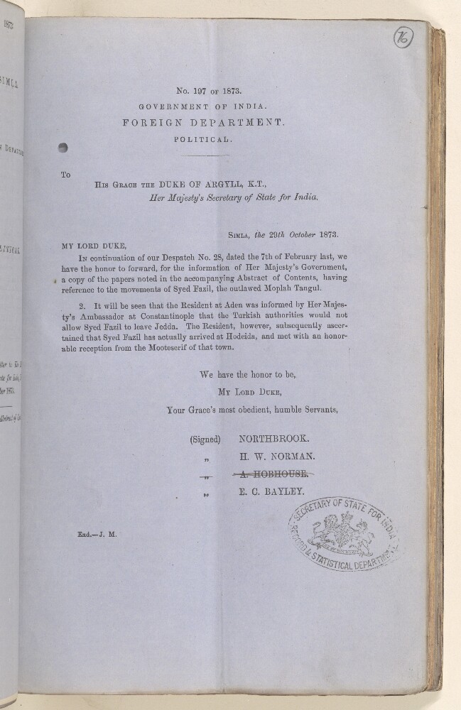
39. Political No. 197 of 1873, Forwarding Copies of Papers Relating to the Movements of Syed Fazil, the Outlawed Moplah Tangul, and his Arrival at Hodeida
- Description:
- Abstract: This item consists of copies of a Political Despatch from the Government of India Foreign Department to the Secretary of State for India, dated 29 October 1873 and received via Brindisi on 24 November 1873, forwarding copies of correspondence regarding the movements of Syed Fazil, the outlawed Moplah Tangul (also referred to as 'the Moplah Priest') [Moplah – Muslims of Malabar] and the latter's arrival at Hodeida [Al Hudaydah] from Jedda [Jeddah]. The correspondence consists of letters from the Secretary to the Government, Bombay [Mumbai], enclosing reports by the Political Resident at Aden. Only Enclosures No. 7 and No. 8 (of Nos. 1-8 listed in the abstract) are present. The despatch is in continuation of Political No. 28 dated 7 February 1873.Physical description: Foliation: the foliation sequence for this description (used for referencing) commences at f 76, and terminates at f 80, as it is part of a larger physical volume; these numbers are written in pencil, are circled, and are located in the top right corner of the recto side of each folio. The sequence contains one foliation insertion anomaly: f 76a.
40. The Nabhani Offering on the History of the Arabian Peninsula
- Description:
- Abstract: Al-Tuḥfat al-Nabhānīya fī tārīkh al-jazīra al-ʻArabīya (The Nabhani offering on the history of the Arabian Peninsula) is by Muḥammad ibn Kahlīfa ibn Ḥamd ibn Mūsā al-Nabhānī (1883 or 1884−1950 or 1951). The author was a teacher at the Masjid al-Ḥarām in Mecca (as was his father). The younger al-Nabhani started this work after his visit to Bahrain, and a request that he write a book treating the history of the current rulers of Bahrain, as well of its ancient emirs and their dealings with friend and foe. As the original plan had been to limit the work to the history of Bahrain, al-Nabhānī initially titled his work al-Nubdha al-laṭīfa fī al-ḥukkam min al-khalīfa (The charming fragment regarding the rulers of the house of al-Khalīfa). When the work was expanded to include the totality of the Arabian Peninsula, its name changed as well. Chapter nine of this work is a large section (with independently numbered pages) on Basra (present-day Iraq), in which al-Nabhani served briefly as judge, and in which he was imprisoned by the British during World War I. The present copy is a revised and expanded second edition, published in 1923−24 at the Maṭbaʻat al-maḥmūdīya publishing house in Cairo.Physical description: 3 volumes in 1 book ; 21 centimeters
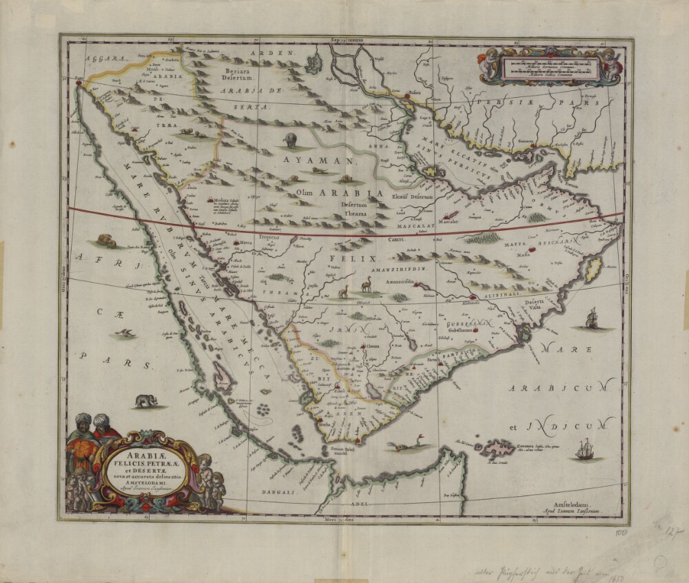
41. A Current and Correct Depiction of Arabia Felix, Arabia Petraea, and Arabia Deserta
- Description:
- Abstract: This map from 1658 was published by Johannes Janssonius (1588-1664), or Jan Jansson. Jansson was born in Arnhem, the son of Jan Jansson the Elder, a publisher and bookseller. Jansson’s maps are similar to those of Willem Janszoon Blaeu (1571-1638), the founder of the Blaeu cartographic firm, and Jansson is sometimes accused of copying from his rival, but many of his maps predate those of Blaeu or cover different regions. This map is very similar to an earlier Blaeu map. The map shows more rivers on the Arabian Peninsula, six in total, than on many other maps. Some town names are badly copied, such as “Bocealima,” which is Blaeu’s “Roccalima.” “Mascalat” is shown as a large and important town. There are dotted lines along the coast from “Calva” in the present-day United Arab Emirates (UAE) to beyond Bahrain Island. The Arabian Gulf is called “Mare elcatif olim Sinus Persicus” (Al Qatif Sea formerly known as the Persian Gulf) and the Strait of Hormuz called “Basora fretum” or Strait of Basra. The Red Sea is called “Mare Rubrum turcis Mare Mecca olim Sinus Arabicus” (Red Sea, named Sea of Mecca by Turks and formerly known as the Arabian Gulf).Physical description: 1 map; color; 42 x 49.50 centimeters

42. Arabia: According To Its Modern Divisions
- Description:
- Abstract: “Arabia According to Its Modern Divisions” shows the Arabian Peninsula with the three-part division traditionally used in European sources into Arabia Petraea, Arabia Deserta, and Arabia Felix. Deserts, seaports, and the pearl beds along the coast are indicated. Qatar is shown as Catura. Four different distance scales—Arabian miles, Turkish miles, Persian parasangs, and British miles—are provided. Published in 1794, the map was compiled and drawn by Samuel Dunn (circa 1723−94), a teacher of mathematics and navigation who made original contributions to solving the problem of determining longitude. In addition to making maps, Dunn wrote a number of books on mathematics and navigation, including The Description and Use of the Universal Planispheres (1759) and The Theory and Practice of the Longitude at Sea (1778). This map was published by the firm of Laurie & Whittle, a partnership of the engraver Robert Laurie (circa 1755−1836) and print seller James Whittle (1757−1818) that was known for its accurate maps and nautical charts.Physical description: 1 map ; 47 x 59 centimeters
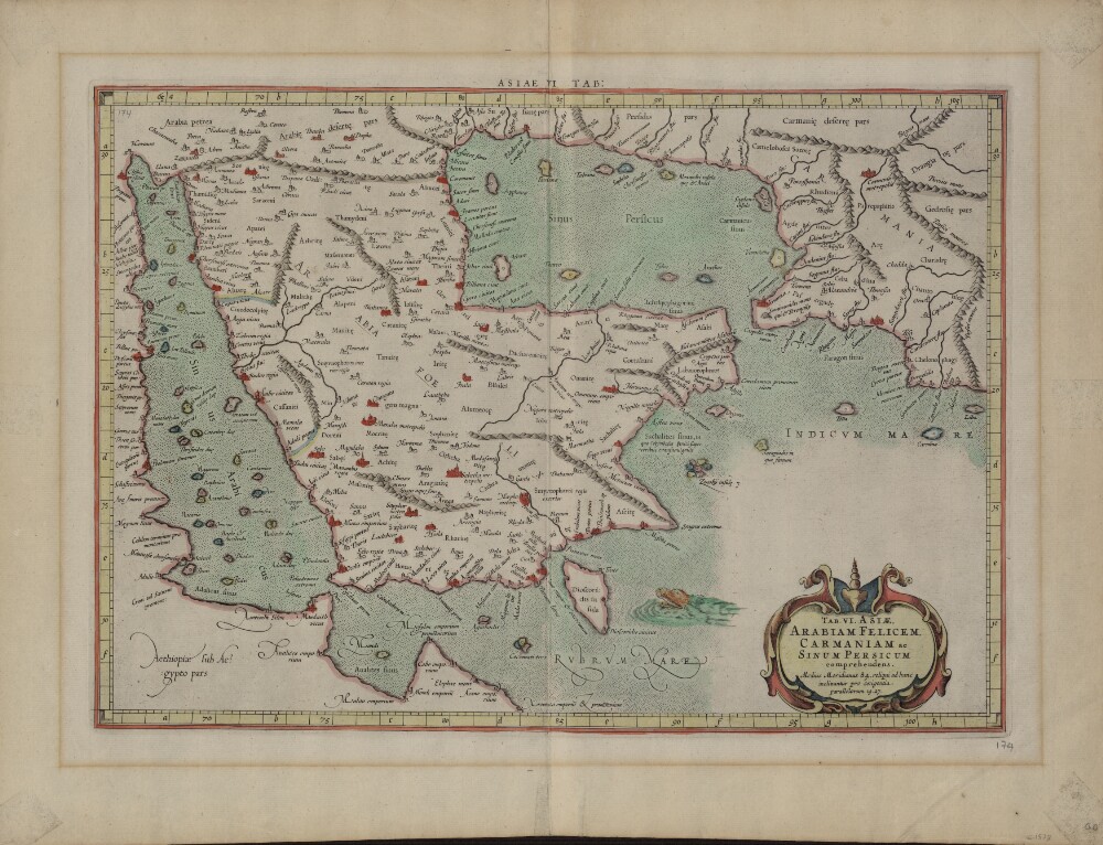
43. Sixth Map of Asia: Which Includes Arabia Felix, Carmania, and the Persian Gulf
- Description:
- Abstract: This map from Ptolemy’s Geographia was published in 1578 and reprinted on many occasions between 1584 and 1704. It is much more finely engraved than maps in previous Ptolemy editions. The map mentions several places in present-day Qatar (Abucei, Leaniti, Themi, Asateni, and Aegei). Names added to this edition of the map include Mesmites Sinus, Idicar, and a second Idicar, located in present-day Kuwait. This name is similar to the island of “Ichara” found near Magorum Sinus. Contemporary research has confirmed that Kharj is the island known to the ancients as “Icara.” One of the major peninsulas shown on the map is named “Chersonesi Extrema,” near Catara. Modern scholarship has identified Chersonesos as Ras Rakn in present-day Qatar. Ichtyophagorium Sinus is the gulf inhabited by the people identified in ancient histories as the “Fish Eaters.” Claudius Ptolemaeus, known in English as Ptolemy, was an ancient mathematician, astronomer, geographer, and astrologer who was born sometime after 83 A.D., most likely in a town in the Thebaid called Ptolemais Hermiou in Roman Egypt. He lived in Egypt and died in Alexandria around the year 168.Physical description: 1 map : copperplate engraving, color ; 31 x 46 centimeters
44. Coll 40/13 ‘Royal Family. Coronation of H.M. King George VI. Invitations to the Sultan of Muscat and the Sheikhs of Bahrain and Koweit, and King of the Yemen.’
- Description:
- Abstract: This file contains correspondence on the coronation of King George VI. The correspondence is primarily between the following: the Secretary of State for India; the Political Resident in the Persian Gulf; the Secretary of State for the Colonies; the Permanent Under-Secretary of State for India; and the Resident at Aden. It includes material relating to the following matters:The journey of Prince Seif-uyl-Islam al-Hussein [Sayf al-Islām al-Ḥusayn bin Yahyā Ḥamīd al-Dīn] of the Mutawakkilite Kingdom of Yemen from London to Paris and RomeThe invitation to the Sultan of Muscat [Sulṭān Sa‘īd bin Taymūr Āl Bū Sa‘īd], the Sheikh of Bahrein [Sheikh of Bahrain, Ḥamad bin ‘Īsá Āl Khalīfah], the Sheikh of Koweit [Sheikh of Kuwait, Aḥmad al-Jābir al-Ṣabāh], and the King of Yemen [Al-Imām al-Mutawakkil Yahyā Muḥammad Ḥamīd al-Dīn] to attend the coronation ceremony of King George VI in LondonThe invitation from the Colonial Office to the Sultan of Lahej [Sulṭān ‘Abd al-Karīm II bin al-Faḍl al-‘Abdalī] and the Sultan of Shehr and Mokalla [Sulṭān of Shihr and Mukalla, Sulṭān Ṣāliḥ bin Ghālib al-Qu‘ayṭī] to attend the coronation ceremony of King George VIThe decision to invite the Arab rulers of the Gulf to the ceremony in light of Lieutenant-Colonel Trenchard Craven William Fowle’s view ‘as to the local importance of not allowing it to be thought in the Gulf that these rulers had been forgotten and the consequent desirability of extending to them some form of invitation though they might not avail themselves of it’.The file also includes ‘Minutes of the 1st Meeting of the Sub-Committee of the Coronation Executive Committee set up to consider questions arising in connection with the invitation of, accommodation for, and entertainment of persons from outside the United Kingdom who are to be treated as either Royal or official Guests for the Coronation’ (folios 101-111).Physical description: The foliation sequence (used for referencing) commences at the inside front cover with 1 and terminates at 112; these numbers are written in pencil, are circled, and are located in the top right corner of the recto side of each folio.
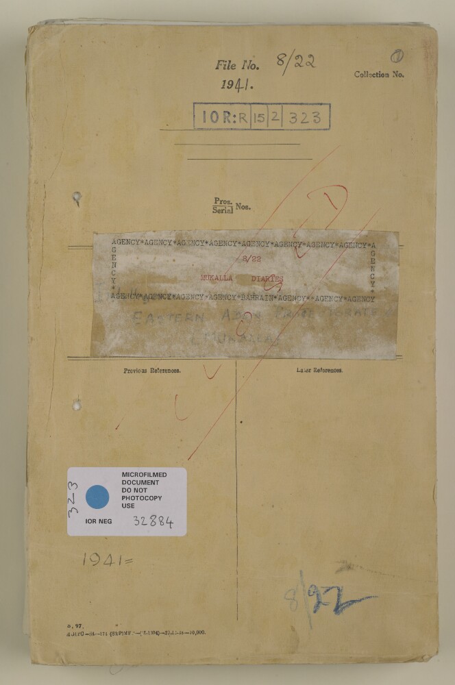
45. File 8/22 Eastern Aden Protectorate Intelligence Summaries
- Description:
- Abstract: The file contains periodic intelligence summaries for the East Aden Protectorate. From the beginning of January 1941 to the end of May 1941 the reports are weekly. From June 1941 they become monthly. The reports are composed by the Resident Adviser, based in Mukalla.Each report consists of an update on the political and tribal affairs of the statelets that make up the Eastern Aden Protectorate, including:the Qu'aiti State of Shihr and Mukalla;the Kathiri State of Seiyun;the Mahri Sultanate of Qishn and Sokotra;the Wahidi Sultanate of Bir Ali and Balihaf;the Shaikhdom of Irqa and Haura;the Indeterminate Area.News from neighbouring countries such as Saudi Arabia, Yemen, and the Western Aden Protectorate was also sometimes included.From April 1942 the reports expand and include important summarised information on finances, education, medical matters, food security, shipping, military and naval matters, agriculture and fisheries, meteorology, internal security, the effects of the war, and slavery.Most likely due to shortages of paper during the war, the reports are sometimes printed on the back of old documents and maps, including a map of Britain and Europe showing an idealised interpretation of Britain's targets and progress in the Second World War. The title ('Britain - The Spear of Attack') and labels are written in Arabic. There is also a page of text referring to a map of shipping routes (not present) and promoting the work of the Royal Navy and its allies. It is likely these were used as propaganda to garner support in the Arab Middle East.Physical description: Foliation: the main foliation sequence (used for referencing) commences at the front cover with 1 and terminates at the last folio with 286; these numbers are written in pencil, are circled, and are located in the top right corner of the recto side of each folio. A previous foliation sequence, which is also circled, has been superseded and therefore crossed out.
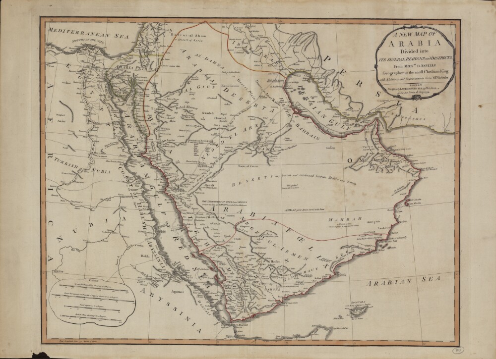
46. A New Map of Arabia: Divided into Its Several Regions and Districts
- Description:
- Abstract: This map of Arabia, published in London in 1794, is an English translation of a map by the French cartographer and geographer Jean-Baptiste Bourguignon d’Anville (1697−1782). Appointed the first geographer to the king of France in 1773, d’Anville was one of the most important mapmakers of the 18th century, known for the accuracy and scientific quality of his maps. The work presented here is said to contain “Additions and Improvements from Mr. Niebuhr,” a reference to Carsten Niebuhr (1733–1815), a German-born Danish explorer and civil engineer who journeyed through Arabia and Yemen in 1762–67 and whose Travels through Arabia and Other Countries in the East (an abridged translation from the original German) was published in Edinburgh in 1792. The map includes cities and towns, coastlines, caravan routes to Mecca, wells, mines, and other geographic features, and brief notations on some of the peoples and kingdoms of the Arabian Peninsula. Qatar is shown as “Catura,” with the notation “Coast little Known” just south of its location. Four distance scales are given: great Arabian miles, great parasangs or Persian leagues, sea leagues, and British miles. The map was published by the London firm of Laurie & Whittle, a partnership of the engraver Robert Laurie (circa 1755−1836) and print seller James Whittle (1757−1818) that was known for its accurate maps and nautical charts.Physical description: 1 map ; 46.5 x 59 centimeters
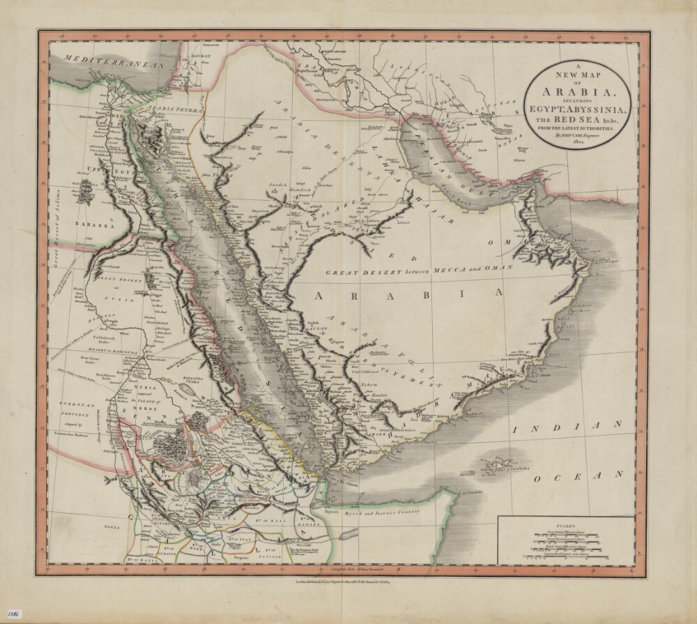
47. A New Map of Arabia, Including Egypt, Abyssinia, the Red Sea, from the Latest Authorities
- Description:
- Abstract: John Cary (circa 1754−1835) was a leading London engraver, map-, chart- and print-seller, and globe maker, active between 1787 and 1834. This map of 1804 shows the Arabian Peninsula and neighboring parts of Africa and the Middle East. Important caravan routes are marked, including the “route of the grand caravan of Sudan from the Niger to Cairo,” “route of the caravan from Batsora [Basra] to Aleppo,” “caravan of Darfowar [Darfur] to Mecca by Dongola,” “caravan of Sudan directly to Mecca by Suakem,” and several other caravan routes to Mecca. Many African kingdoms are shown, their borders marked with colored lines, as is a speculative source of the Nile. The northern coast of Somalia is called “Myrrh and Incense Country.” The zigzag line in the Red Sea indicates the course of La Venus, a French frigate that sailed on a voyage of discovery in the Red Sea, Persian Gulf, and Indian Ocean in 1785−88. The map includes many other notes that reflect the state of European geographic understanding of this region at the beginning of the 19th century. Four distance scales are given: great Arabian miles, Persian parasangs, British statute miles, and common French leagues.Physical description: 1 map : hand colored ; 44 x 50 centimeters
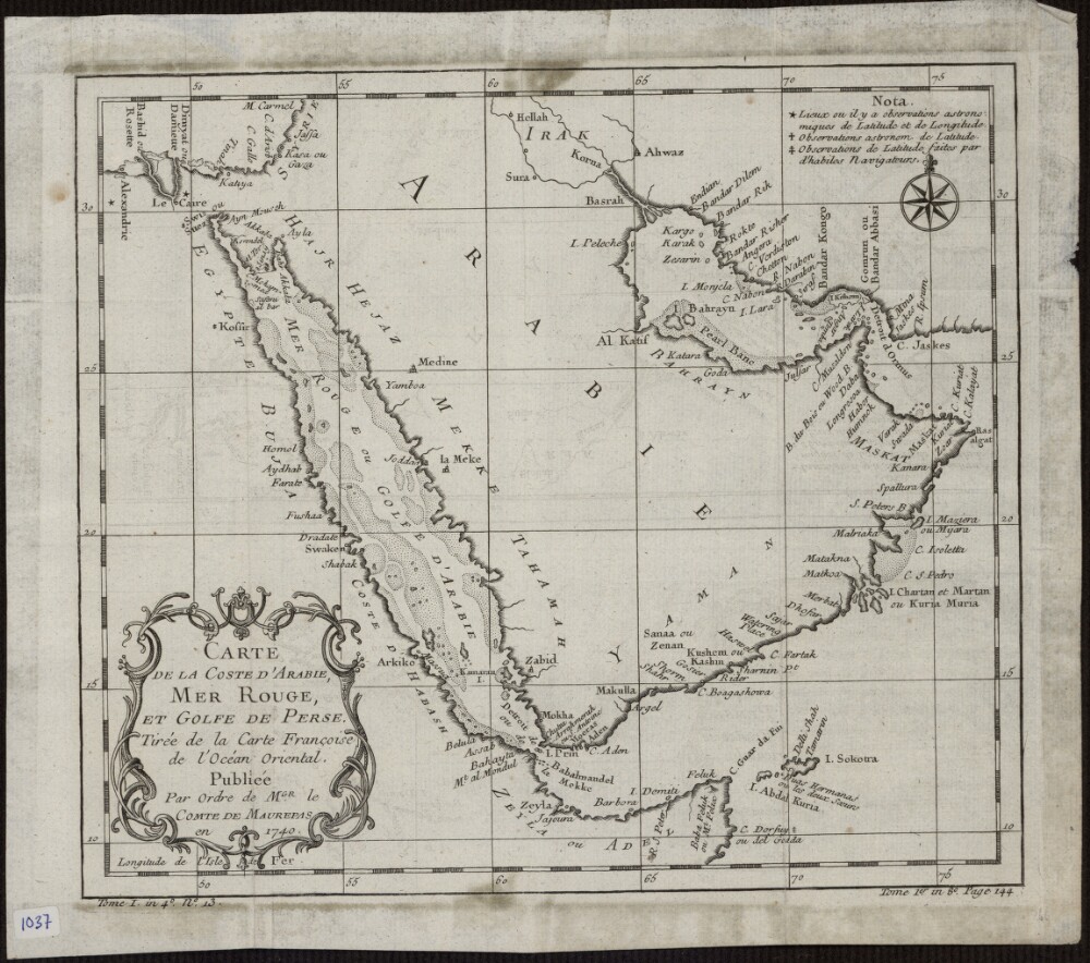
48. Map of the Coast of Arabia, the Red Sea and the Persian Gulf
- Description:
- Abstract: This 1740 map is by the French cartographer and hydrographer Jacques-Nicolas Bellin (1703-72). It was published by order of Jean-Frédéric Phélypeaux, Count de Maurepas (1701-81), secretary of state under King Louis XV. The map focuses exclusively on the coastlines, and provides no detail about the interior of the Arabian Peninsula. It shows pearl banks along the coast from Bahrain to Julfar. Qatar is noted (“Katara”), but the peninsula that it occupies is not accurately drawn. Kuwait is not shown, but the island of “Peleche” is indicated. The Red Sea is indicated as Mer Rouge ou Golfe d’Arabie (the Red Sea or the Gulf of Arabia). The note at upper right explains the use of three different symbols: a star to indicate places whose locations had been determined by astronomical observations of latitude and longitude; a cross to indicate places whose locations had been determined by astronomical observations of (only) latitude; and a modified cross to indicate places whose locations had been determined by latitudinal observations made by skilled navigators.Physical description: 1 map; black and white; 20.50 x 23.50 centimeters