1 - 10 of 10
Number of results to display per page
Search Results

1. ‘Persian Gulf. Abolition of the Slave Trade in the Principal ports of-’
- Description:
- Abstract: The item consists of copies and extracts of correspondence, minutes and resolutions cited in, or enclosed with, letters from the Government of Bombay [Mumbai] to the East India Company Court of Directors. The item relates to attempts by the Government of Bombay to suppress the trade in enslaved people in the Gulf and on the coasts of Cutch, Kattywar and Karachi [Kachchh, Kāthiāwār and Karāchi]. In particular, the item relates to:A report in 1837 by Abdoola bin Awaz [Abdullah bin ‘Awaz] that 233 young women were abducted from the Burburra Coast [Berbera] by the crews of Joasmee [al-Qawāsim] boats to be sold at the principal ports on the Arabian side of the GulfConcerns expressed by Samuel Hennell, Resident in the Persian Gulf, in 1837-38 regarding the difficulty in persuading the Imaum [Imam] of Muscat and the principal Arabian chiefs to prohibit their subjects from participating in the trade in enslaved people and his fear that reducing this trade conducted by these rulers would simply result in the trade being carried on by others from the Ottoman Porte [Ottoman Empire] and Persia [Iran]Hennell’s success in obtaining agreements in 1838-39 with several rulers on the Arabian peninsula, the contents of which: extend the boundary line beyond which it is prohibited to carry enslaved people from between Cape Delgado and Diu Head to between Cape Delgado and Pussein [Pasni]; authorise the British Government to search any vessels belonging to the rulers’ subjects found eastward of this boundary line which may be suspected of carrying enslaved people and to liberate the enslaved people on board; confirm that Soomalee [Somali] people are to be considered as ‘hoor’ [ḥurr] or ‘free’, therefore the selling of them as enslaved people is to be considered an act of ‘piracy’.The above agreements being signed by: Seed Said bin Sultan, the Imaum of Muscat [Sayyid Sa‘īd bin Sulṭān Āl Bū Sa‘īd]; Shaik Sultan bin Suggur of Rasel Khymah [Shaikh Sulṭān I bin Ṣaqr al-Qāsimī of Ra’s al-Khaymah and Sharjah]; Shaik Mukhtoom bin Butye of Debaye [Shaikh Maktūm I bin Buṭṭī Āl Bū Falāseh of Dubai]; Shaik Abdoollah bin Rashed of Amulgaveen [Shaikh ‘Abdullāh bin Rāshid al-Mu’allā of Umm al-Qaywayn]; Shaik Rashid bin Humeed of Ejman [Shaikh Rāshid I bin Ḥumaid al-Nu‘aymī of ‘Ajmān]; and Shaik Khuleefa bin Shakboot of Aboothabee [Shaikh Khalifa bin Shakhbūṭ Āl Nahyān of Abu Dhabi]Discussions of how these agreements differ from previous treaties, including the 1820 General Maritime Treaty [General Treaty with the Arab Tribes of the Persian Gulf] and the 1822 treaty signed between the Imaum and Captain Moresby of HMS ship Menai, and whether parts of the treaties are too ambiguousA complaint in 1840 by Captain A H Nott, Commanding the Company ship Tigris, that despite the new agreements he is unable to interfere with vessels found with enslaved people on board because he cannot prove that the people have been kidnapped directly by the crews of the vesselsMinutes by the Board of the Government of Bombay lamenting the apparent ineffectiveness of the new agreements and suggesting further measures to be taken.The item contains a copy of the Bombay Government Gazette (folios 1015-1022) from 21 May 1840, which, amongst other notifications, announces the new agreement with the Imaum of Muscat in English, Arabic, Persian, Gujarati and Marathi. In addition, Captain Nott’s reports (folios 1030-1031 and 1041-1044) provide details on the number of enslaved people being trafficked annually, how they come to be enslaved, and at which prices they are sold.There are numerous copies of the 1838-39 agreements at: ff 935-936; 943; 945-946; 991; 994-995; 999-1000; 1008-1009; and 1050.Principal correspondents include: Hennell; Nott; Thomas MacKenzie, Acting Assistant in charge of the [Persian Gulf] Residency; the governments of Bombay and India; and agents at Muscat and Shargah [Sharjah].The title page of the item contains the following references: ‘Bombay Political Department’, ‘P.C. [Previous Communication] 3075, Draft 431, 1841’, ‘Collection No. 5’ and ‘Examiner’s Office’.Physical description: Foliation: the foliation sequence for this description (used for referencing) commences at f 929, and terminates at f 1078, as it is part of a larger physical volume; these numbers are written in pencil, are circled, and are located in the bottom right corner of the recto side of each folio.Pagination: the item also contains an original pagination sequence.
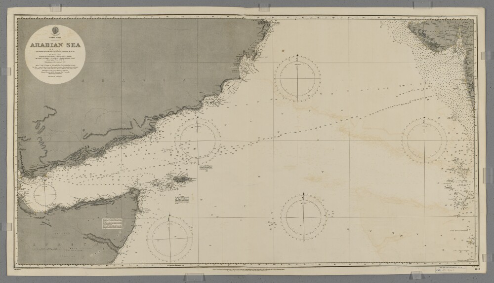
2. 'Arabian Sea'
- Description:
- Abstract: Chart 1012.Hydrographic chart covering the Arabian Sea, including the Gulf of Aden, between latitudes 7° 00' 00" N and 22° 32' 30" N. Includes the coastlines of the southern Arabian Peninsula, the Horn of Africa and parts of north-western India. Portrays hydrology, including depths by soundings and contours, some sands and rocks, relief by spot heights and hachures, vegetation, railways, settlements and place names, and includes buoys (highlighted in watercolour) and navigational notes.Eastern portion of the chart compiled by officers of the East India Government (1828-63); western portion by commanders Stafford Bettesworth Haines and I P Sanders [most likely John Parke Sanders] and lieutenants Albany Moore Grieve, Thomas Grere Carless, William Charles Barker and other officers of the Indian Navy (1836-49). Engraved by Malby & Sons. Published at the Admiralty 1899 with small corrections.Physical description: Materials: Printed, with additions in watercolour, on paperDimensions: 627 x 1173mm, on sheet 689 x 1231mm
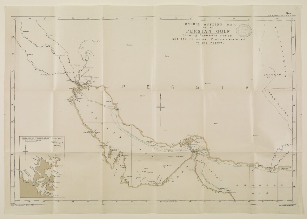
3. 'GENERAL OUTLINE MAP OF THE PERSIAN GULF Showing Submarine Cables and the Principal Places mentioned in the Report.'
- Description:
- Abstract: The map shows parts of the Arabian Peninsula, Persia, Afghanistan and Baluchistan, indicating major settlements and the routes of named submarine cables in the Persian Gulf, the Gulf of Oman and the Arabian Sea. The map also indicates hydrology and frontier lines.An inset map drawn at a scale of approximately 1:66,000 is entitled, 'Musandim Promontory. (Enlarged)'.The map is Map 1 in 'Persian Gulf and Gulf of Oman' (Naval Intelligence Department No. 694), 1903. A printing statement reads, 'Weller & Graham Ltd. Litho, London.'.Physical description: Materials: Printed in colour on paperDimensions: 456 x 703mm, on sheet 527 x 753mm
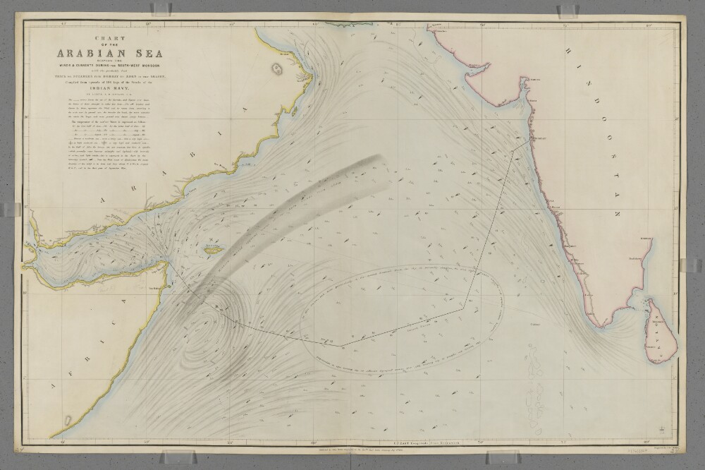
4. 'Chart of the Arabian Sea Shewing the Winds & Currents during the South-West Monsoon with the probably best Track for Steamers from Bombay to Aden in that Season.'
- Description:
- Abstract: Covers the Arabian Sea south of latitude 25°N, including the Gulf of Aden. Includes the coastlines of the Horn of Africa, the south-east Arabian Peninsula and the west coast of India. Includes a hinterland of approximately fifteen miles. Portrays hydrology, including rocks, relief by hachures, settlements, place names, and includes some navigational notes. Also shows meteorological information, including the strength and direction of currents and winds, surface water temperatures and sea turbulence, and includes meteorological notes and a suggested route for shipping between Aden and Bombay [Mumbai, India]. The chart has been enhanced with watercolour and some place names and routes added in pencil.Compiled by Lieutenant Alfred Dundas Taylor, Indian Navy. Engraved by J & C Walker. Published by John Walker, Geographer to the Honourable East India Company.Physical description: Materials: Printed, with manuscript additions in watercolour and pencil, on paper (backed with linen)Dimensions: 619 x 987mm, on sheet 654 x 1004mm
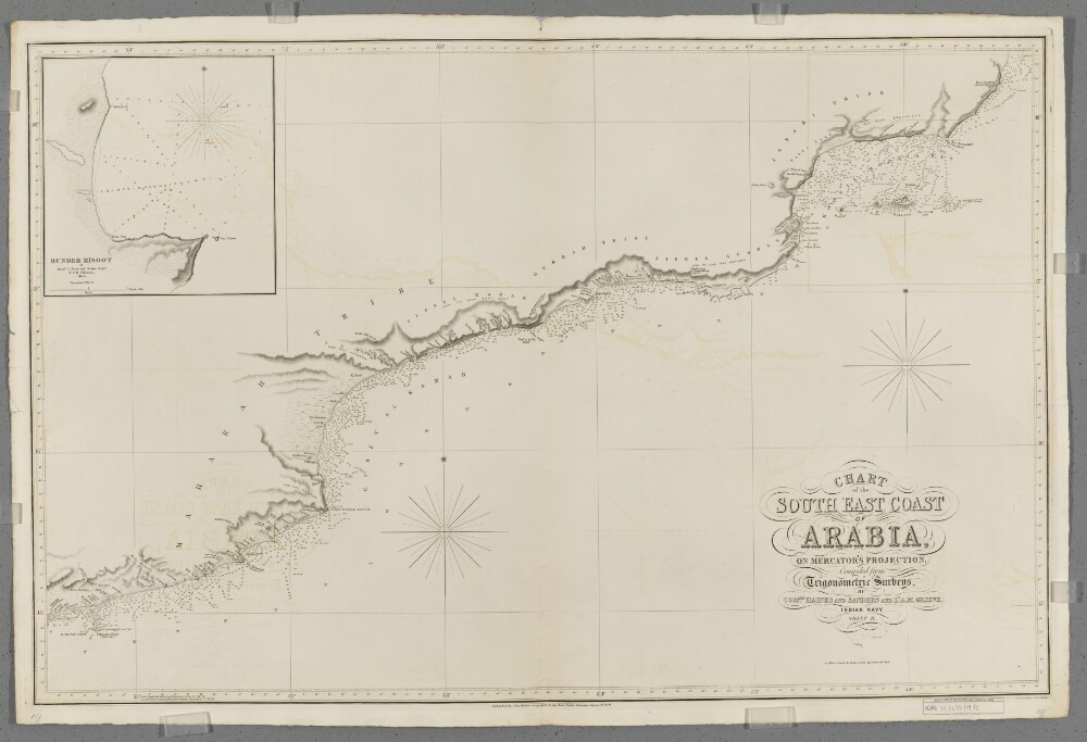
5. 'Chart of the South East Coast of Arabia'. Sheet II
- Description:
- Abstract: Covers a 480-mile length of the Arabian Sea coast of the Arabian Peninsula from Misenaat [Musayni'ah, Yemen] north-eastwards to Ras Saugra [Ra's Sawqirah, Oman], together with a hinterland of approximately twenty miles. Portrays hydrology, including depths by soundings, relief by spot heights, hachures and rock drawing, sand dunes, vegetation, settlements, tribal lands and place names, and includes topographical and hydrographic notes.Includes an inset of Bundar Risoot [Bandar Raysut, Oman] at scale approximately 1:12,150, created by Messrs C Nixon and Barker Mids[hipma/en].Compiled by Commanders Stafford Bettesworth Haines and I P Sanders [most likely John Parke Sanders] and Lieutenant Albany Moore Grieve, Indian Navy. Engraved by J & C Walker. Published by John Walker, Geographer to the East India Company.Physical description: Materials: Printed on paperDimensions: 616 x 964mm, on sheet 683 x 1026mm
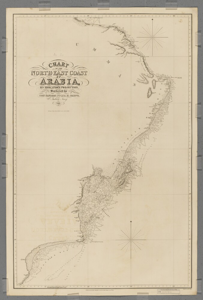
6. 'Chart of the North-East Coast of Arabia'
- Description:
- Abstract: Covers a 380-mile length of the Arabian Sea coast of Umman [Oman] from Ras Saugra [Ra's Sawqirah] north-eastwards to Ras el Hadd [Ra's al Hadd], and then a 150-mile length of the Gulf of Aden coast north-westwards to Muskat [Muscat]. Includes a hinterland of approximately twenty miles. Portrays hydrology, including depths by soundings and some contours, relief by spot heights, hachures and rock drawing, sand dunes, vegetation, settlements, tribal lands and place names, and includes topographical and hydrographic notes.Surveyed by Commander I P Sanders [most likely John Parke Sanders] and Lieutenant Albany Moore Grieve, Indian Navy. Engraved by J & C Walker. Published by John Walker, Geographer to the East India Company.Physical description: Materials: Printed on paper (backed with linen)Dimensions: 941 x 604mm, on sheet 1011 x 673mm
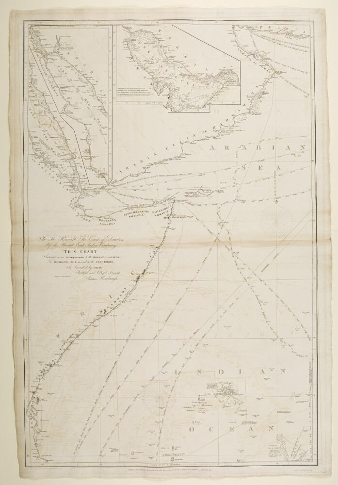
7. ‘Chart Intended as an Accompaniment to the Book of Directions for Navigating to, from, and in the East Indies. Engraved by John Bateman’
- Description:
- Abstract: Imprint:Published by James Horsburgh, Hydrographer to the East India Company. 10th Feb 1816. Additions to 1830.Distinctive Features:Depth shown by soundings.Nautical chart of the Arabian Sea showing the eastern coast of Africa, coast of the Arabian Peninsula and the Gulf of Oman with the various trade routes indicated. Compiled from the surveys carried out by the Bombay Marine’s officers between 1820 and 1829.Contains two inset maps: one depicting the Red Sea from Suez to Sawakin, and another showing the coasts of the Persian Gulf.Numerous annotations on hazardous features including rocks, shoals, reefs and currents cover the face of the map.Contains dedication to the Court of Directors of the United East India Company from James Horsburgh.Physical description: Dimensions:926 x 609 mm, on sheet 996 x 668 mm
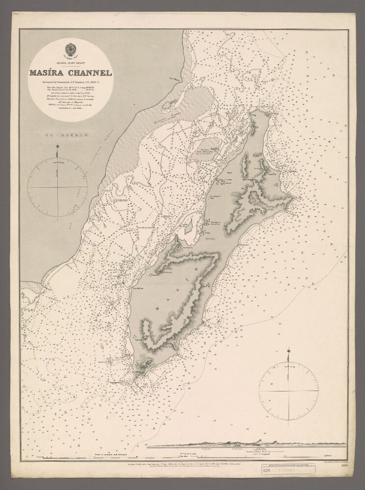
8. 'Masira Channel'
- Description:
- Abstract: Chart 1089.Hydrographic chart covering Masira Channel [Turʻat Masirah], the Arabian Sea, Masira Island [Jazirat Masirah] and a thirty-five-mile length of the eastern Oman coast. The Masira Channel, twelve miles wide and sixty miles long, separates Masira Island from the Omani mainland. Portrays hydrology, including depths by soundings and contours, sands, rocks, anchorages, relief by spot heights and hachures, vegetation, settlements, watering places and place names, and includes topographical notes and navigational aids, including prominent landscape features and buildings.Includes an annotated view, at an unspecified scale, of Masira Island from the south.Chart surveyed by Commander John Parke Sanders, Indian Navy 1845-1846. Engraved by Davies & Company. Published at the Admiralty, 1888.Physical description: Materials: Printed on paperDimensions: 633 x 481mm, on sheet 685 x 508mm
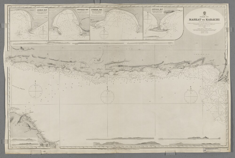
9. 'Maskat to Karachi'
- Description:
- Abstract: Chart 38.Hydrographic chart covering a 570-mile route through the Gulf of Oman and Arabian Sea from Maskat [Masqat], Oman, east-north-eastwards to Karachi, British India [Pakistan]. The sheet also depicts a 170-mile length of Omani coast in the vicinity of Maskat and a 630-mile length of coast between Cape Jashak, Persia [Damagheh-ye Jask, Iran] eastwards to Karachi.Portrays hydrology, including depths by soundings and contours, sands, mud, rocks and anchorages, relief by spot heights and hachures, vegetation, settlements, public buildings, telegraph offices and place names, and includes topographical notes and navigational aids, including buoys, lights and prominent buildings.Includes insets of Jashak Bay [Khalij-e Jask], Persia, at scale 1:121,000; Chahbar Bay [Khalij-e Chah Bahar], Persia, at scale 1:96,800; Gwatar Bay [Dahaneh-ye Gowatar], Persia and British India, at scale 1:96,800; and Gwadar Bay, [Gwadar Bay (West and East), British India, at scale 1:96,800.Ten annotated sketches of significant navigational views, at unspecified scales, on both the north and south coasts of the Gulf of Oman and Arabian Sea are also included.Chart compiled from the surveys of captains George Barnes Brucks, Stafford Bettesworth Haines, Thomas Grere Carless, Albany Moore Grieve, Charles Golding Constable, Arthur Whatley Chitty and Arthur William Stiffe, all late Indian Navy. Engraved by Edward Weller. Published at the Admiralty, 1874.Physical description: Materials: Printed on paperDimensions: 668 x 1043mm, on sheet 688 x 1049mm
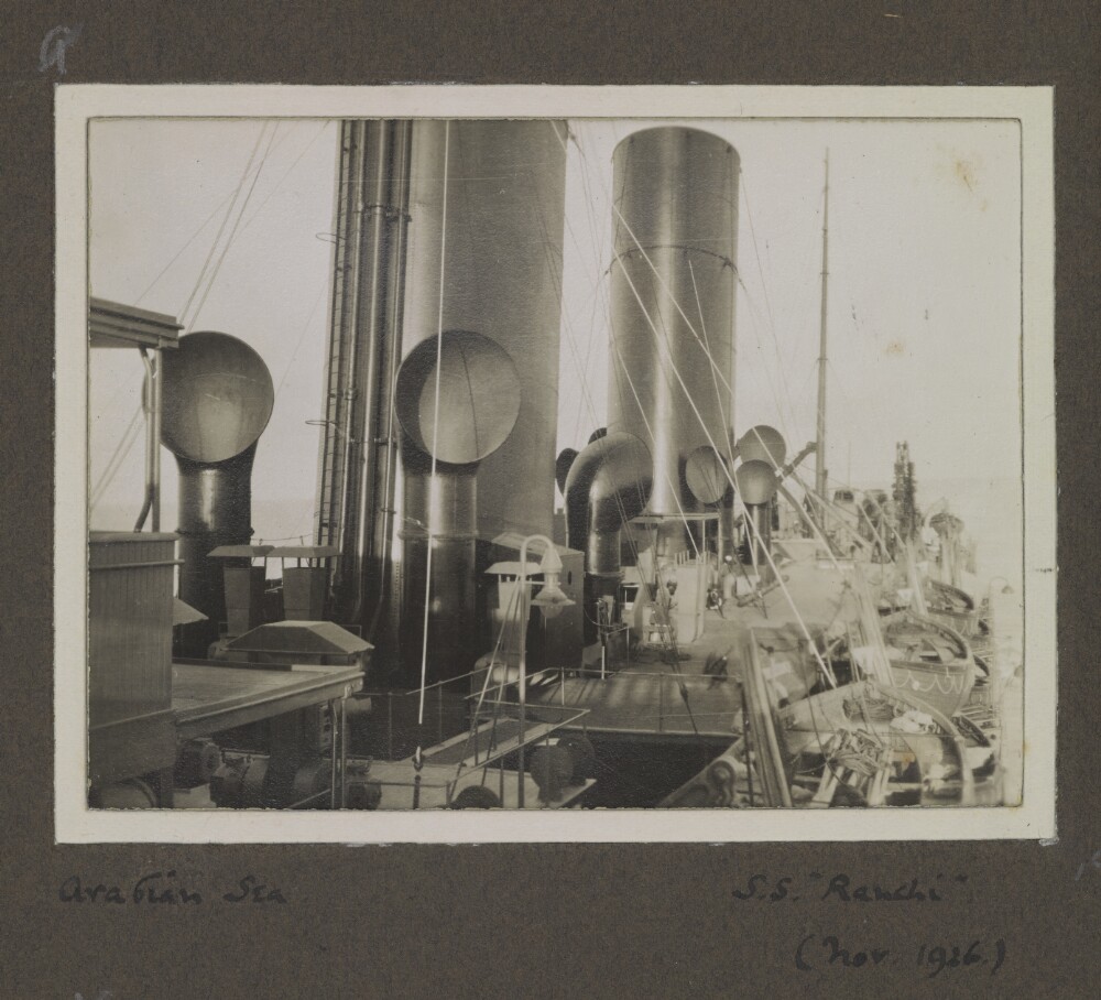
10. Album of views in India, the Middle East and Europe. Photographer: Rev. Edwin Aubrey Storrs-Fox
- Description:
- Abstract: Genre/Subject Matter:The album contains historical landscape, maritime and architectural snapshot views at Udaipur, Mount Abu, Bombay, Aden, Suez Canal, Boulogne, various locations in England, Sialkot, Jammu and Marala [Murala].Elements:1 ‘Udaipur: Fateh Sagar.’2 ‘Mount Abu: Plains from “The Crags”’3 ‘Mount Abu: Residency & Lake.”4 ‘Mount Abu: Lake & Residency.’5 ‘Mount Abu: from Cart Road’6 ‘Mount Abu: Road to Dilwara’7 ‘Mount Abu: Dilwara temples’8 ‘Mount Abu: Dilwara Temples (Adinath).’9 ‘Mount Abu: Dilwara Temples(Adinath).’10 Mount Abu: Dilwara Temples (Adinath).’11 ‘Mount Abu: Dilwara Temples (Nemnath).’12 ‘Mount Abu: Dilwara Temples (Nemnath).’13 ‘Mount Abu: Dilwara Temples (Nemnath).’14 ‘Bombay: S.S. “Ranchi”’15 ‘Arabian Sea: S.S. “Ranchi”’16 ‘Aden: Steamer Point’17 ‘Aden: S.S. “Ranchi”’18 ‘Aden: S.S. “Mantua”’19 ‘Suez Canal’20 ‘Boulogne: Eastern Cemetery. L.A.S.F.’21 ‘Boulogne: Eastern Cemetery. L.A.S.F.’22 ‘Boulogne: Eastern Cemetery. L.A.S.F.’23 ‘Boulogne: Eastern Cemetery. L.A.S.F.’24 ‘Boulogne: Eastern Cemetery. L.A.S.F.’25 ‘Boulogne: Eastern Cemetery. L.A.S.F. (1st grave)’26 ‘Boulogne: Eastern Cemetery.27 ‘Boulogne: Eastern Cemetery. L.A.S.F. (1st grave)’28 ‘Boulogne: Eastern Cemetery. L.A.S.F.’29 ‘Glaisdale: I.E.S.F., P.M.S.F., W.E.S.F., M.F., E.S.F.’30 ‘Sandsend: P.M.S.F., W.C.S.F.’31 ‘Saltersgate: E.S.F., M.F., I.E.S.F., P.M.S.F., W.C.S.F.’32 ‘Saltersgate: W.C.S.F., E.A.S.F., E.S.F., M.F., I.E.S.F.’33 ‘Lilla Cross: I.E.S.F.’34 ‘Fountains Abbey: P.M.S.F., I.E.S.F., W.C.S.F.’35 ‘Sialkot: Soldier’s Home & W.C.S.F.’36 ‘Sialkot: Holy Trinity Church’37 Sialkot: E.C.B. and “Amy”’38 ‘Sialkot: Holy Trinity Church’39 ‘Sialkot: Holy Trinity Church’40 ‘Sialkot: Holy Trinity Church’41 ‘Sialkot: Holy Trinity Church’42 ‘Sialkot: 4th/7th Dragoon Guards’43 ‘Sialkot: 4th/7th Dragoon Guards’44 ‘Sialkot: 4th/7th Dragoon Guards’45 ‘Jammu.’46 ‘Jammu.’47 ‘Jammu.’48 ‘Marala: River Chenab’Distinctive Features:Each window mount is formed of a two-tone card and paper cut out: the dark brown paper of the album is laid over a cream-coloured mounting card, which forms a c. 2-4 mm frame around each image.Inscriptions:Brief handwritten captions in English, including dates, accompany each print.In pencil a consecutive numbering system (1–48) is written alongside each image, usually near the lower right corner of the image. An alternative image sequence (a–b only, sequence repeats on each page) is indicated in pencil near the upper left corner of each image.This has been crossed out, also in pencil.Pagination – since crossed out – is indicated in the upper right or left corner of each page in pencil.Labels:A gold, stamped design appears in the lower right corner of the front cover of the album with a sun-like symbol and the words ‘PHOTO’ GRAPHS’Physical description: Dimensions:243 x 163 mmMaterials:Mid-brown cloth, dark brown paper, cream-coloured card, silver gelatin prints, black ink and pencil.Condition:The album is in good condition except for minor surface dirt throughout. Several images are buckling and rising out of their mounts due to incorrect mounting.Foliation:‘a–b’; ‘1–48’; ‘1–24’Process:Silver gelatin print