Abstract: This volume is a 'Report from Lieut-General Sir P. H. N. Lake K.C.B., K.C.M.G. Commanding I.E.F. "D" on the Defence of Kut-Al-Amarah under Major-General C. V. F. Townshend, C.B., D.S.O., 3 December 1915-29 April 1916' published by the General Staff, India (Government Central Branch Press, Simla: 1916). The report concerns the siege of Kūt and consists of a copy of a letter (No. 168-15-O), dated July 1916, from Lieutenant-General Sir Percy Henry Noel Lake, Commanding Indian Expeditionary Force D, to the Chief of the General Staff, Army Headquarters, Simla (folio 2r), submitting a despatch (No. 15-10-A), dated 10 March 1916, from Major-General Charles Vere Ferrers Townshend, Commanding, 6th Indian Division, to the General Officer Commanding, Indian Expenditionary Force D (folios 2v-8r), including appendices (folios 8v-21). The report is marked 'Confidential' on the front cover (folio 1).Physical description: Foliation: The foliation sequence commences at the front cover and terminates at the inside back cover; these numbers are written in pencil, are circled, and are located in the top right corner of the recto side of each folio.Pagination: The volume also contains an original printed pagination sequence.
Abstract: The volume contains the following minutes and proceedings:First Meeting, 2 March 1908. Evidence of Sir Richmond Thackeray Willoughby Ritchie.Second Meeting, 6 March 1908. Evidence of Sir J Mackay.Third Meeting, 11 March 1908. Evidence of Mr Frank Clark Strick and Mr E Lloyd.Fourth Meeting, 17 March 1908. Evidence of Sir Louis William Dane.Fifth Meeting, 19 March 1908. Evidence of Mr P Thomas and Mr G Lloyd.Sixth Meeting, 25 March 1908. Evidence of Mr Henry Finnis Blosse Lynch, and Major J A Douglas.Seventh Meeting, 30 March 1908. Evidence of Sir William Lee-Warner, and Colonel Charles Edward Yate.Digest of Evidence in Order of Witnesses.Digest of Evidence by Subjects.Appendices:Appendix 1. Terms of Reference.Appendix 2. Memorandum respecting British Interests in the Persian Gulf. Foreign Office, Confidential (9161).Appendix 3. Supplementary Memorandum respecting British Interests in the Persian Gulf. Foreign Office, Confidential (9404).Appendix 4. Lights and Buoys required at Ports in the Persian Gulf. Statement by the Director of Naval Intelligence.Appendix 5. The Provision of Wireless Telegraph Stations in the Persian Gulf. Statement by the Director of Naval Intelligence.Appendix 6. The Cost of the Proposed Lighthouses at Ras Musandim.Appendix 7. Trade and Shipping in the Persian Gulf. Memorandum by the Director of Naval Intelligence.Appendix 8. Memorandum on the Position of British Trade in the Persian Gulf. Prepared in the Board of Trade.Appendix 9. Memorandum by Mr H F B Lynch, MP.Appendix 10. The Nushi-Seistan Railway Project. The Bunder-Dilam-Shiraz Railway Project. Extracts from a report by Lieutenant L E Hopkins.Appendix 11. Memorandum handed to M Isvolsky, 14 October 1908.Appendix 12. British and German Shipping in the Persian Gulf. Memorandum prepared in the Board of Trade.Maps:Folio 76. Sketch to illustrate positions of Flagstaffs at Elphinstone Inlet and Sheep Island (Musandim Peninsula).Folio 87. Sketches of Approaches to Kuweit Harbour and Shatt Al Arab, compiled from various authorities.Folio 118v. Map of Mohammerah and district prepared in 1850. Shows the proposed Turkish, Persian and mediating Commissioners' lines.Folio 152. Sketch Maps to Shew Railways in Asia Minor.Folio 153. Map showing the Persian Gulf and adjacent countries.Physical description: Foliation: the foliation sequence commences at the inside front cover with 1, and terminates at the inside back cover with 164; these numbers are written in pencil, are circled, and are located in the top right corner of the recto side of each folio. Pagination: the volume also contains an original printed pagination sequence (xi, 297pp, 5 maps).
Abstract: A printed volume regarding the geology of Mesopotamia and the surrounding region. The volume was prepared on behalf of the Admiralty and printed by the Admiralty Naval Staff, Intelligence Department.The volume contains five maps and nine diagrams.The volume is divided up into the following chapters:I. The Geological Position of Mesopotamia;II. The Geology of Mesopotamia;III. The Geology of the Persian Gulf;IV. The Geology of the Persian Front;V. The Geology of the Armenian Borderland;VI. The Geology of the Arabian Borderland;VII. The Geological History of Mesopotamia and its Borderlands, and the Origin of the Mesopotamian Sunkland;VIII. The Economic Geology of Mesopotamia and its Borderlands;IX. Bibliography;Note on Transliteration of Place-Names;Index.Physical description: Pagination: the volume contains an original printed pagination sequence.Foliation: the file's foliation sequence commences at the inside front cover and terminates at the inside back cover; these numbers are written in pencil, are circled, and are located in the top right corner of the recto side of each folio (except for the front cover, where the folio number is located on the verso).
Abstract: The file contains memoranda, with some correspondence and copy telegrams, relating to the supply of horses, mules and ponies for the cavalry, infantry and artillery in Mesopotamia [Iraq] (the supply of animals for the Mesopotamia Campaign was undertaken by the Government of India).Notably covers rates of horse wastage in Mesopotamia, statistics of which were regarded by the War Office as unduly high; requirement estimates and requests by General Officer Commanding, Mesopotamia, in view of prospective military operations; difficulty in maintaining supply of remounts; shipping logistics; desire to expedite shipments of animals to factor in acclimatisation periods; proposals to send out inspecting and advising officers to Mesopotamia to improve efficiency of horse management; provision of additional remount staff and veterinary officers; and ensuring remount requirements for India itself whilst meeting demands of Mesopotamia campaign.The papers indicate that horses, mules and ponies were supplied from China, Australia, India and North America.The papers indicate that ‘wastage’ meant animals killed, died or destroyed. The main causes, apart from military engagement, were long hours in saddle, insufficient water and food, insufficient rest and feeding time, unsatisfactory standards of horsemanship and poor horse management.The primary correspondents are: the Commander-in-Chief, India; the War Office; the General Officer Commanding, Mesopotamia; and General Headquarters, Salonika.Physical description: Foliation: the foliation sequence (used for referencing) commences at the front cover with 1, and terminates at the inside back cover with 68; these numbers are written in pencil, are circled, and are located in the top right corner of the recto side of each folio. An additional foliation sequence is present in parallel; these numbers are written in coloured crayon.
Abstract: Imprint:S.D.O. Topo. Dy. No. 14, Exd. C.J.A., April 1911.Distinctive Features:Map produced to illustrate the proposed railway and irrigation scheme in Mesopotamia recommended by Sir William Willcocks. Includes a key and an explanatory note on railways with distances between Baghdad and Basra reported. Issued with notes providing further details concerning suggested works along Tigris, Nahr Melcha and Hai, and cost calculations (‘ENCLOSURE C’, folio 233).Inscriptions:In pencil, above title: ‘0/126’ and ‘Persia/1021-En’.Physical description: Dimensions:505 x 630 mm
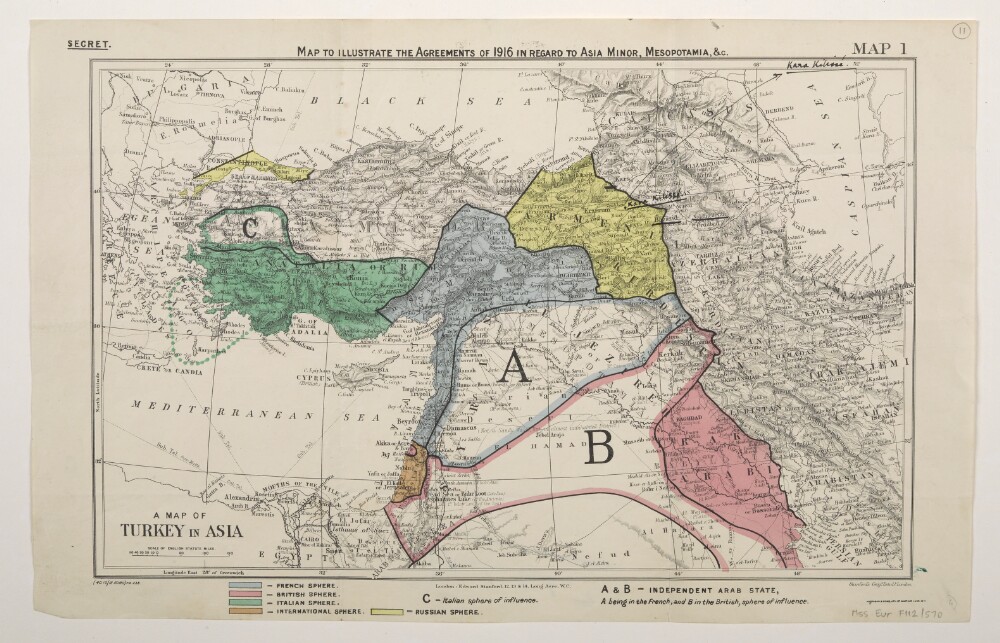
Abstract: Classified 'Secret'.The map bears a secondary title 'A Map of Turkey in Asia'.Bears the printed designation 'Map 1'. Depicts a proposed division of the Ottoman Empire into spheres of influence and protection by the Allied powers. The division is based on agreements reached between 1916 and the end of the First World War. Portrays hydrology, relief by spot heights and hachures, roads and tracks, railways, submarine telegraph lines, settlements, place names and international boundaries. A black overprint combined with watercolour washes show French, British, Italian, Russian and International spheres of influence, including provision for an independent Arab state within the French and British spheres. Some place names have been highlighted in manuscript.The base map bears the imprint 'London: Edward Stanford, 12, 13 & 14, Long Acre, W.C.' The printer's imprint 'Harrison & Sons, Lith. St. Martins Lane, W.C.' and print code '(40.10/18.6360)F[oreign].O[ffice].238.' have been added later.Verso bears an undetermined annotation.Physical description: Materials: Printed in colour, with additions in watercolour, ink and crayonDimensions: 243 x 388mm, on sheet 286 x 449mm
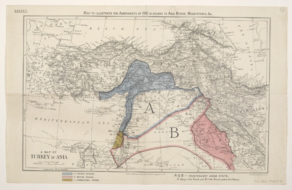
Abstract: Classified 'Secret'.The map bears a secondary title 'A Map of Turkey in Asia'.Depicts a proposed division of the Ottoman Empire into spheres of influence and protection by the Allied powers. The division is based on agreements reached between 1916 and the end of the First World War. Portrays hydrology, relief by spot heights and hachures, roads and tracks, railways, submarine telegraph lines, settlements, place names and international boundaries. A black overprint combined with watercolour washes show French, British and International spheres of influence, including provision for an independent Arab state within the French and British spheres.The base map bears the imprint 'London: Edward Stanford, 12, 13 & 14, Long Acre, W.C.'Verso bears the annotation '2nn' [?] and the stamp 'Eastern Department'.Physical description: Materials: Printed in colour, with additions in watercolour, pencil and rubber stampDimensions: 243 x 388mm, on sheet 284 x 447mm
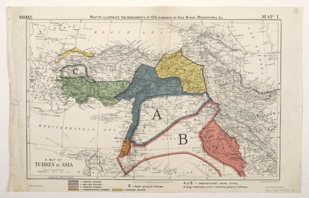
Abstract: Three identical map sheets.Classified 'Secret'.The map bears a secondary title 'A Map of Turkey in Asia'.Bears the printed designation 'Map 1'. Depicts a proposed division of the Ottoman Empire into spheres of influence and protection by the Allied powers. The division is based on agreements reached between 1916 and 1919. Portrays hydrology, relief by spot heights and hachures, roads and tracks, railways, submarine telegraph lines, settlements, place names and international boundaries. Various blocks of overprinted colour shading correspond to French, British, Italian, Russian and International spheres of influence, including provision for an independent Arab state within the French and British spheres.The base map bears the imprint 'London: Edward Stanford, 12, 13 & 14, Long Acre, W.C.' The printer's imprint 'Harrison & Sons, Lith. St. Martins Lane, W.C.' and print code '(350.1/19.6648) F[oreign].O[ffice].' have been added later.Folio 14 has manuscript boundary additions in pencil and crayon.Physical description: Materials: Printed in colour, with manuscript additions in pencil and crayonDimensions: 243 x 388mm, on sheet 289 x 452mm
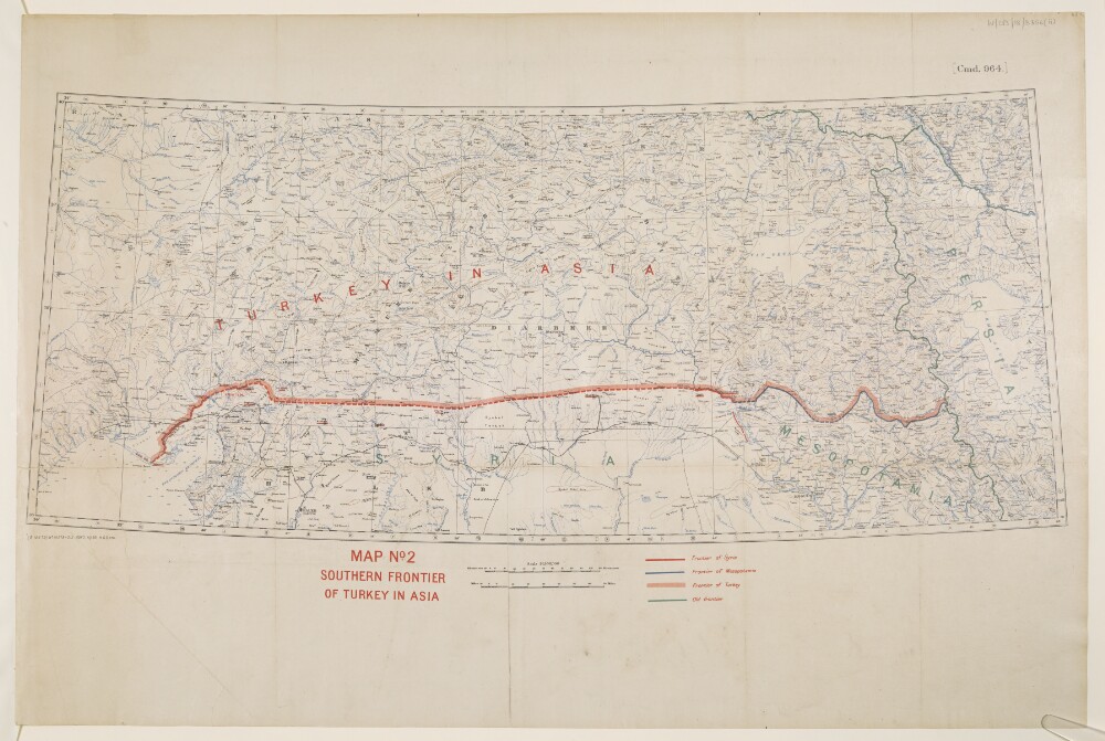
Abstract: This map shows Turkey where it is included in Asia and indicates the boundaries between Turkey, Syria, Mesopotamia and the Old Frontier. The map also indicates relief with contours.The map includes a printing statement which reads '(B 16479) WT 18378-212.5050.10/20.H&S,LTD.'Physical description: Materials: Printed in colour on paper with manuscript additions in coloured inkDimensions: 310x 733mm, on sheet 505 x 759mm
Abstract: Sheet 1 (Eastern) bears the shelfmark IOR/X/3635/1Sheet 2 (Western) bears the shelfmark IOR/X/3635/2Covers the Persian Gulf, Strait of Hormuz and the coastlines of Persia [Iran], Mesopotamia and the north-eastern Arabian Peninsula eastwards to the Musandam Peninsula. Includes a hinterland of approximately twelve miles. Portrays hydrology, including depths by soundings, and rocks, relief by hachures and rock drawing, vegetation, settlements and place names in English and Arabic, and includes topographical and hydrographic notes. The coastlines are highlighted in watercolour.'Constructed from the Trigonometrical Surveys. Made by Order of the Hon[ourab]le the Court of Directors of the United English East India Company; and to whom it is Respectfully Dedicated by their most obedient Servant George Barnes Brucks, Commander HC [Honourable Company] Marine. 1830.'Original surveys by Lieutenants John Michael Guy, George Barnes Brucks, Robert Cogan, William Eales Rogers and Stafford Bettesworth Haines, 1821-29. Engraved by Richard Bateman. Published by James Horsburgh, Hydrographer to the Honourable East India Company, 1832.Physical description: Materials: Printed, with manuscript additions in watercolour, on paper (backed with linen)Dimensions: Sheet 1 (Eastern) 725 x 580mm, on sheet 803 x 644mm; Sheet 2 (Western) 731 x 580mm, on sheet 820 x 648mm
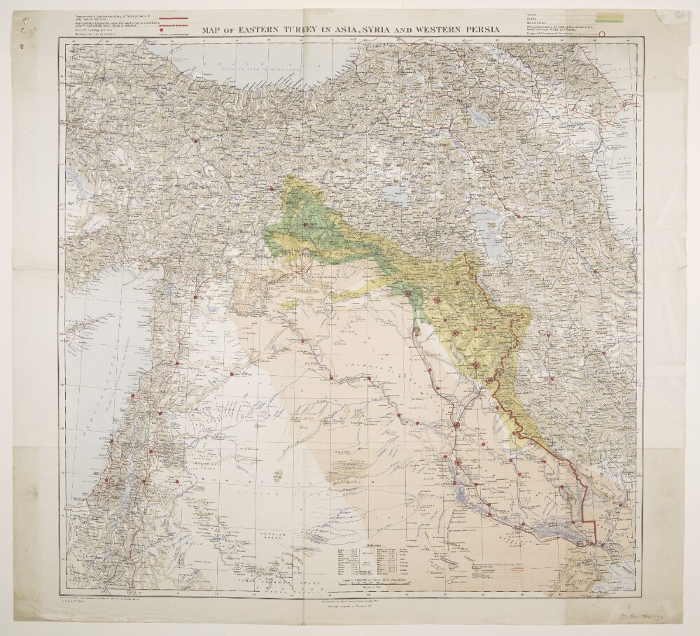
Abstract: Folios 33 and 34 are copies of the same map.Bears the imprint 'Published by the Royal Geographical Society, 1910. Railways inserted to November, 1917' and the series designation 'G[eographical].S[ection].,G[eneral].S[taff]., No. 2901.' Portrays hydrology, relief by spot heights and hachures, roads, railways, telegraphs, settlements, ancient canals, place names and international boundaries. The sheet bears the printed note 'International Boundaries as in July, 1914'. A 1921 edition of this base map is at Maps 46970.(44.) although lacks a GSGS designation, yet includes a set of accompanying notes published by the Royal Geographical Society in 1910, including details of compilation material.Coloured overprints depict areas of 'Kurds', 'Arabs', 'Mixed Races' and 'debateable lands between Arabs and Kurds'; possible boundaries for Mesopotamia; aircraft landing-grounds and railways; and proposed permanent garrisons.Physical description: Materials: Printed in colourDimensions: 612 x 745mm, on sheet 780 x 860mm
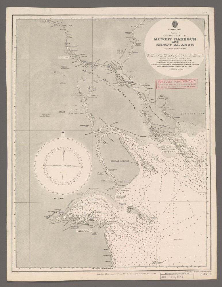
Abstract: Chart F3293.Hydrographic chart of the Shatt al Arab in southern Mesopotamia from the vicinity of Al Basra [Al Basrah, Iraq] approximately 100 miles south-eastwards to its mouth at the head of the Persian Gulf. Also includes the approaches to Kuweit [Kuwait] Harbour. Portrays hydrology, including depths by soundings and contours, sands, rocks and mud, relief by spot heights and shading, vegetation, cultivation, canals, settlements including significant buildings, forts and tombs, and place names, and includes topographical notes and navigational aids, including buoys, lights and prominent buildings.Compiled 'from various authorities'. Engraved by Davies & Company. Published by the Admiralty and 'issued for Fleet purposes' 1902, with new editions 1904, 1907, 1909 and 1912, and small corrections.The sheet bears the stamps:'For Fleet Purposes Only. Care is to be taken that this chart is not allowed to get into the hands of unauthorised persons' in red on the map face.The number '170.12' in black in the upper right margin.Physical description: Materials: Printed on paperDimensions: 597 x 456mm, on sheet 660 x 507mm