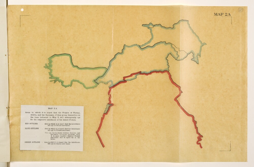
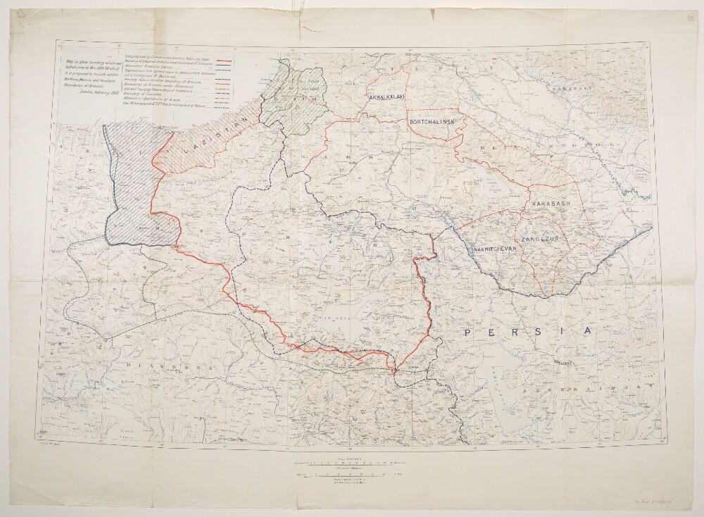
Abstract: Map is an overlay to Mss Eur F112/570, f 28 and forms a part of Mss Eur F112/570, ff 24-30.The title and legend are printed on a small paper sheet that has been pasted over the south-west corner of the map. Map portrays, by variously coloured boundaries, areas in which it is 'hoped that the inhabitants will opt for [British, French or Italian] assistance'. Bears the imprint '8146.' [Published by the Political Intelligence Department, Foreign Office, 21 November 1918.]Another copy of this map is at Mss Eur F112/570, f 20.Physical description: Materials: Printed in colour on tracing paperDimensions: 243 x 393mm, on sheet 290 x 450mm
Abstract: Memorandum possibly prepared by C G Campbell, 22 January 1903. The document is a recent historical overview of Turkish claims to the Arabian (southern) coast of the Persian Gulf, with particular focus on Qatar (referred to as El Katr throughout), Odeid [al-‘Udaid], and the Trucial Coast. There are hand-written notes on sources and references in the left-hand margin.Physical description: Foliation: the sequence commences at the first folio and terminates at the last folio; these numbers are written in pencil, are circled, and are located in the top right corner of the recto side of each folio.
Abstract: This memorandum concerns British relations with Turkey in the Persian Gulf and was written by Frederic Arthur Hirtzel in December 1910. The immediate question it addresses is 'the desirability of concluding a treaty with a Sheikh or Sheikhs of the El Katr [Qatar] peninsula as a bulwark against Turkish aggression' and comments on a telegram by Percy Zachariah Cox. It is divided into three parts; the first part assesses the general Anglo-Turkish situation in the Gulf and examines anti-British and pro-German developments as Constantinople.The second part concurs that the publication of the secret agreement with Shaikh Mubarak bin Sabah of Koweit [Kuwait] is necessary to clarify matters and lists settlements claimed by the Shaikh of Koweit. The third part argues that having achieved that they should make treaties on the lines of Trucial Coast agreements with 'Bin Thani' [Shaikh Jāsim bin Muḥammad Āl Thānī]. The memorandum discusses how such an agreement would be justifiable because by excluding foreign powers it would maintain the status quo.The memorandum concludes that it was desirable to conclude treaties with the Qatar tribes and that this would require giving them a guarantee against Turkish aggression.Physical description: Foliation: The foliation sequence commences at the first folio, and terminates at the last folio; these numbers are written in pencil, are circled, and are located in the top right corner of the recto side of each folio. Pagination: An original printed pagination sequence is also present in the booklet.
Abstract: This memorandum was written by Sir Frederic Arthur Hirtzel in January 1917. Its purpose is to explain 'why the exclusion of Italy from Western and Southern Arabia and the Red Sea littoral is important in British interests'. It notes the importance of Arabia lying as it does along two of the main approaches to India from Europe. Hirtzel's memorandum also notes the absence of an effective state in Arabia, and the concomitant influence of tribes and their chiefs.It reviews the strategic importance of Aden and its protectorate along with the significance of the Aden-Yemen frontier in the context of British relations with the Imam of Sanaa and Turkey (paragraphs 4-5). It notes that the Italian ambitions are mainly focused on the Yemen and that the Italo-Turkish war made Italy the most unpopular 'Christian power' in the Muslim world. It analyses the implications of any British consent to an Italian occupation of the Yemen.It concludes that the 'present war has shown the use that may be made against us of Islam' and contends that the success of H M Government in the Middle East 'depends to a large extent on the transfer of the Caliphate from Turkey to Arabia. This in turn depends on the possibility of making the ruler of the Hejaz sufficiently strong to be able to pose as an independent sovereign. This again depends upon keeping the Christian powers at a sufficient distance.' The memorandum finishes by noting that it was for these reasons Britain took the precaution of inserting in the Anglo-French convention [Sykes-Picot agreement] that the British and French Governments agree that they will not themselves acquire and will not consent to a third Power acquiring territorial possessions in the Arabian peninsula with a sphere of influence being seen as equivalent to territorial possession.Physical description: Foliation: The foliation sequence commences at the first folio and terminates at the last folio; these numbers are written in pencil, are circled, and are located in the top right corner of the recto side of each folio. Pagination: The booklet also has an original printed pagination sequence.
Abstract: The file details the situation in Turkey as of 15 March 1920, and presents the potential consequences, for both the Turks and the Allies, of presenting Turkey with a peace treaty which is too severe. It is Written by the General Staff, War Office. It is broken down into two parts and 4 appendices as follows:'Part I – Information';'Part II – Operations';'Appendix A' – Table of Allied units and strength broken down by nation and location;'Appendix B' – Table of present personnel and equipment of the Armenian army;'Appendix C' – Table of the location of the Turkish army and armaments officially reported by the Turks;'Appendix D' – Report recording the impressions of a British lieutenant-colonel who, during December and January, 1919-20, made a tour of the Turkish side of the Greek Line around Smyrna.Physical description: Foliation: the foliation sequence commences at the first folio with 1, and terminates at the last folio with 8; these numbers are written in pencil, are circled, and are located in the top right corner of the recto side of each folio.Pagination: the volume also contains an original printed pagination sequence.
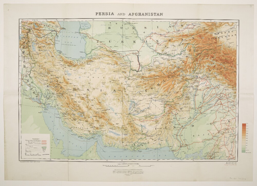
Abstract: Printed sheet bearing the series designation 'Geographical Section, General Staff No. 2149' and providing full country coverage of Persia [Iran] and Afghanistan with significant partial coverage of present-day Turkey, Armenia, Azerbaijan, Turkmenistan, Pakistan and Iraq. Portrays, hydrology, relief by spot heights, gradient tints and shading, railways, roads, telegraphs, settlements, water sources, place names, and international boundaries. The sheet bears the imprints 'War Office, April 1912', 'Additions, July 1918' and 'Railways revised, Jan.1919'.Manuscript additions portray boundary amendments labelled as 'Persian Territorial Claims'.The verso bears the manuscript note 'Persia Claims'.Physical description: Materials: Printed in colour, with manuscript additions in inkDimensions: 501 x 777mm, on sheet 626 x 886mm
Abstract: The file contains three extracts from German papers, translated and commented on by Captain Offley Bohun Stovin Fairless Shore in 1894, detailing the latest up-to-date information on the armed strength of Turkey at the time.The extract from the
International Revuefor November 1893, discusses press underestimation of Tukey's military system, covering the Artillery Reorganisation Programme of 1886-87, the subdivision of the empire into territorial zones, military reform, mobilisation arrangements, armament, cavalry, and regiment organisation.In contrast, two extracts from
Die Reichswehrdiscuss the incompleteness of the existing Turkish military preparations.
Die Reichswehrdated 11 February 1994 covers the distribution (dislocation) of troops, unsatisfactory armament, and lack of training for officers.
Die Reichswehrdated 21 March 1894 breaks down the dislocation of the Turkish army, and covers the lack of armaments, and of cavalry and artillery horses.Physical description: Foliation: the foliation sequence commences at the front cover with 1, and terminates at the inside back cover with 8; these numbers are written in pencil, are circled, and are located in the top right corner of the recto side of each folio. Pagination: the volume also contains an original printed pagination sequence.
Abstract: This volume is a report submitted to the British Air Ministry by Air Vice-Marshal John Frederick Andrews Higgins. It consists of a chronological narrative of significant military events in Iraq during his time as Air Officer Commanding, British Forces in Iraq, from April 1924 until November 1926. It is divided by year and by geographical area.The report discusses general military activities undertaken during the period, including the aerial observation of settlements and groups deemed potentially dangerous to the Government, the movements of British and Iraqi troops, and the training of the Iraq Army by British officers.It notably covers the following:Turkish attempts to assert control over the Mosul Vilayet, including ‘infiltration’ of northern Iraq by Turkish personnel, the build-up of troops on the Turkey-Iraq border, and incursions of Turkish cavalry units across the border, which were stopped by British aerial bombardmentBritish planning for the defence of Mosul in the event of a full-scale Turkish invasion, the eventual resolution of the Turkey-Iraq border dispute by the decision of the League of Nations, and a subsequent agreement between Turkey, Iraq, and BritainKurdish resistance to British occupation and the central Iraqi Government, focusing on the continuing anti-British activities of Shaikh Mahmud Barzanji [Maḥmūd Barzanjī], particularly: British ground and aerial attacks on Kurdish villages; a clash between Assyrian levy troops and local Muslim inhabitants at Kirkuk; the suppression of an uprising led by Shaikh Mahmud, including discussions with Riza Khan [Reżā Shāh Pahlavī, Shāh of Iran] about coordination between Iraq and Persia [Iran] against Shaikh Mahmud; British attempts to protect Jaf [Jaff] tribespeople from Shaikh Mahmud’s demands for money during their migration to Persia; and punitive attacks by the British on tribesmen from the Auroman [Hawraman] region for supporting Shaikh MahmudIssues in southern Iraq, primarily involving Akhwan [Ikhwān] raids on nomadic Iraqi herding communities, including: steps taken by the British Government to prevent these raids, such as improved communications in the desert borderlands; aerial bombing of raiding groups; and the detailed mapping of the area to improve the accuracy of British counterattacks against the Ikhwan. The report also mentions the bombing of the house of Shaikh Salim Al Khayun [Sālim al-Khayyūn] in the village of Chubaish [Al-Chibayish], and the Shaikh’s subsequent surrender to Government authoritiesFighting between the forces of ‘Daham, Chief of the Syrian Shammar Jarba’ [Dahhām bin al-Hādī bin al-ʿĀṣī al-Jarbā] and ‘Ajill, Chief of the Iraqi Shammar Jarba’ [‘Ujayl al-Yāwar al-Jarbā], and details the deployment of British armoured cars and aeroplanes to assist Ajill in fighting Daham’s forces.The report contains six appendices:‘Appendix A- Forces in Iraq, April, 1924’‘Appendix B- Note on History of Sheikh Mahmud Prior to April, 1924’‘Appendix C- Composition of Frontier Force under Colonel Commandant H.T. Dobbin, C.B.E., D.S.O., September, 1924’‘Appendix D- Composition of Chapforce under Colonel Commandant J.G. Chaplain, C.B.E., D.S.O.’‘Appendix E- Anti-Akhwan Organisation’‘Appendix F- Reduction of Garrison Following Treaty with Turkey’.Four maps are included in the report. These are catalogued as ‘‘Iraq-Persia Map No. 1’ (IOR/L/PS/20/C204, f 32); ‘Map No. 2’ (IOR/L/PS/20/C204, f 33); ‘Map No. 3’ (IOR/L/PS/20/C204, f 34); and ‘Basra. Map No. 4’ (IOR/L/PS/20/C204, f 35).Physical description: Foliation: the foliation sequence (used for referencing) commences at the front cover with 1, and terminates at the inside back cover with 36; these numbers are written in pencil, are circled, and are located in the top right corner of the recto side of each folio.Pagination: the volume also contains an original printed pagination sequence.
Abstract: The volume, marked confidential, is
Report on the Arms Traffic, 1st July 1911 to 30th June 1913 (including a note on the operations of the Makran Field Force in April and May 1911), prepared by the General Staff, India, and printed at the Government Monotype Press, 1913. The report begins with a preface (folio 5) and is then divided into seventeen sections, plus appendices. The geographical scope of the report includes Persia, Afghanistan, the Persian Gulf, the Arabian Peninsula, and Turkey. The report covers blockade measures, systems of intelligence, exporters from Europe, and prices.The note on operations of the Makran Field Force comes as an appendix and is written by Captain SG Craufurd, Gordon Highlanders Intelligence Officer, at Jask on 10 May 1911.Physical description: Foliation: the foliation sequence commences at the front cover with 1 and terminates at the inside back cover with 22; these numbers are written in pencil, are circled, and are located in the top right corner of the recto side of each folio.Pagination: the volume also contains an original printed pagination sequence.
Abstract: Copy of Mss Eur F112/570, ff 17-23.Volume comprising 7 folios numbered 24 to 30. Produced to accompany 'Memorandum respecting the Settlement of Turkey and the Arabian Peninsula' published by the Political Intelligence Department, Foreign Office, 21 November 1918. Includes four map sheets numbered 1, 2, 2A and 3 together with explanatory notes relating to maps 2 and 3; the explanatory notes bear the imprint '[920-1 A]'.Physical description: Materials: Printed in colour, with manuscript additions in crayonDimensions: 340 x 205mm, with fold-out maps 290 x 452mm or smallerBinding: Thin light buff card, bound with two stitches; evidence of previous staples
Abstract: Volume comprising 7 folios numbered 17 to 23. Produced to accompany 'Memorandum respecting the Settlement of Turkey and the Arabian Peninsula' published by the Political Intelligence Department, Foreign Office, 21 November 1918. Includes four map sheets numbered 1, 2, 2A and 3 together with explanatory notes relating to maps 2 and 3; the explanatory notes bear the imprint '[920-1 A]'.A second copy is at Mss Eur F112/570, ff 24-30.Physical description: Materials: Printed in colourDimensions: 340 x 205mm, with fold-out maps 290 x 452mm or smallerBinding: Thin light buff card, bound with two stitches; evidence of previous staplesFolio 23 (back cover) lacks lower right corner
Abstract: Created by the War Office, 1920. The sheet bears the series designation 'G[eographical].S[ection].G[eneral].S[taff]. No. 2944', and covers a 300 mile by 500 mile area of eastern Turkey under consideration for ceding to Armenia in the aftermath of the First World War. Also includes parts of present-day Azerbaijan, Georgia, Iran, Iraq and Russia. Portrays, hydrology, relief by contours and spot heights, railways, settlements, place names, and ten categories of existing and proposed internal and international boundaries.The verso bears the manuscript note 'Armenia'.Physical description: Materials: Printed in colourDimensions: 557 x 890mm, on sheet 712 x 980mm