Abstract: The volume discusses the ongoing negotiations in Constantinople between the Ottoman, British and Russian Governments through 1912 and 1913 regarding the Turco-Persian Frontier. Also discussed is the decision in July 1913 to establish a delimitation commission to which Albert Charles Wratislaw and Arnold Talbot Wilson are appointed as representatives of the British Government.Also discussed in the volume is the region of Kermanshah and in particular Qasr-i-Shirin [Qaşr-e Shīrīn], along with the Anglo-Persian Oil Company's concerns over the rights accorded to them in their 1901 concession should some of that territory be ceded to Turkey.Further discussion relates to the movements of Russian and Turkish troops near the frontier and the withdrawal of Turkish troops from certain places along the frontier.This volume is part two of two. Each part includes a divider which gives the subject and part numbers, the year the subject file was opened, the subject heading, and a list of correspondence references contained in that part by year. This is placed at the back of the correspondence.Physical description: Foliation: the foliation sequence commences at the first folio with 1 and terminates at the last folio with 334; these numbers are written in pencil, are circled, and are located in the top right corner of the recto side of each folio.The foliation sequence does not include the front and back covers, nor does it include the two leading and ending flyleaves. A previous foliation sequence, which is also circled, has been superseded and therefore crossed out.
Abstract: Intelligence report by Major Norman Napier Evelyn Bray, Political Intelligence Officer attached to the India Office, on Soviet activities and influence in the Middle East and the implications for British interests in the region.The document was prepared as a departmental minute. It discusses several matters, including: the Soviet alliance with Turkish and Arab nationalists across the region, but with a particular reference to Mesopotamia; Italian support (in money and arms) of Turkish nationalists; the need for the British and the French to work together closely to protect their interests; the military strength of all parties.The report contains two appendices, as follows:I - Suggested measures for dealing with the Bolshevist Menace in Mesopotamia and Persia;II - A. Conditions proposed by the Bolsheviks for acceptance of Turkish Nationalists; B. Terms of agreement concluded by Bolsheviks with Mustafa Kemal Pasha.There are extensive notes in the left hand margin throughout the report with details on sources and other comments.Physical description: Foliation: the sequence commences at the first folio and terminates at the last folio; these numbers are written in pencil, are circled, and are located in the top right corner of the recto side of each folio. A second foliation sequence is also present in parallel between ff 3-15; this sequence is written in ink, and is located in the same position as the main sequence.
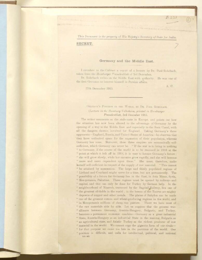
Abstract: This printed memorandum, by Joseph Austen Chamberlain, contains a report of a lecture 'Germany and the Middle East', by Dr Paul Rohrbach given at the Hamberg Volksheim which was printed in
Hamburger Fremdenblatt, 3 December 1915.The report discusses Rohrbach's opinions on the current situation in Europe and how Germany now had an advantage following the opening up of routes to the Middle East and the Suez Canal through the provision of railways and money to Turkey. The lecture also focused on Germany's need for raw materials, how access to the Middle East can provide them with oil, minerals, cotton and wheat, and the potential future economic benefits posed by the war-time alliance of Germany, Austria-Hungary, Bulgaria and Turkey. The lecture concludes with the suggestion that as Germany cannot compete with Britain in its Naval strength it could use the Suez Canal as a point of pressure to try to secure access to the sea and its own position in the heart of Europe.Physical description: Foliation: The foliation commences and concludes on folio 6, as it is part of a larger physical volume. These numbers are written in pencil, are circled, and are located in the top right corner of the recto side of each folio. An additional former foliation sequence is also present in the volume; these numbers are also written in pencil, are not circled, and can be found in the same position as the main sequence.
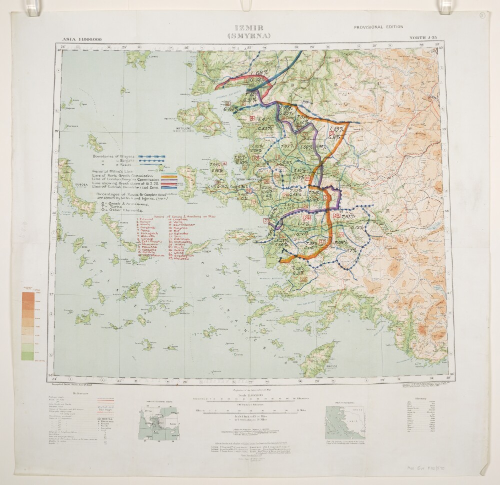
Abstract: Relates to the Treaty of Sèvres (1920).Geographical Section, General Staff No. 2555, Sheet North J-35, Izmir (Smyrna), Provisional Edition. Covers Izmir, western Turkey and surrounding land and sea areas to a radius of approximately 150 miles. Portrays hydrology, soundings, relief by spot heights and gradient tints, roads and tracks, railways, telegraphs, settlements, place names, post and telegraph offices, and international and internal boundaries. Bears the imprint 'Compiled at the Royal Geographical Society under the direction of the Geographical Section, General Staff. Drawn and printed at the War Office, 1916.'Manuscript annotations depict boundaries of Vilayets, Sanjaks and Kazas; General Milne's Line; Line of Paris Greek Commission; Line of London Smyrna Commission; Line showing Greek claim of 19 February 1920; Line of Turkish Demilitarized Zone; and percentages of Races for complete Kazas, together with a list of Kazas. The manuscript annotations have been used in the compilation of folio 6.Verso bears the annotation 'Smyrna Sanjak'.A copy of this map, without the annotations, is filed at Maps MOD GSGS 2555.Physical description: Materials: Printed in colour, with manuscript additions in coloured ink, watercolour and crayonDimensions: 446 x 541mm, on sheet 636 x 650mm
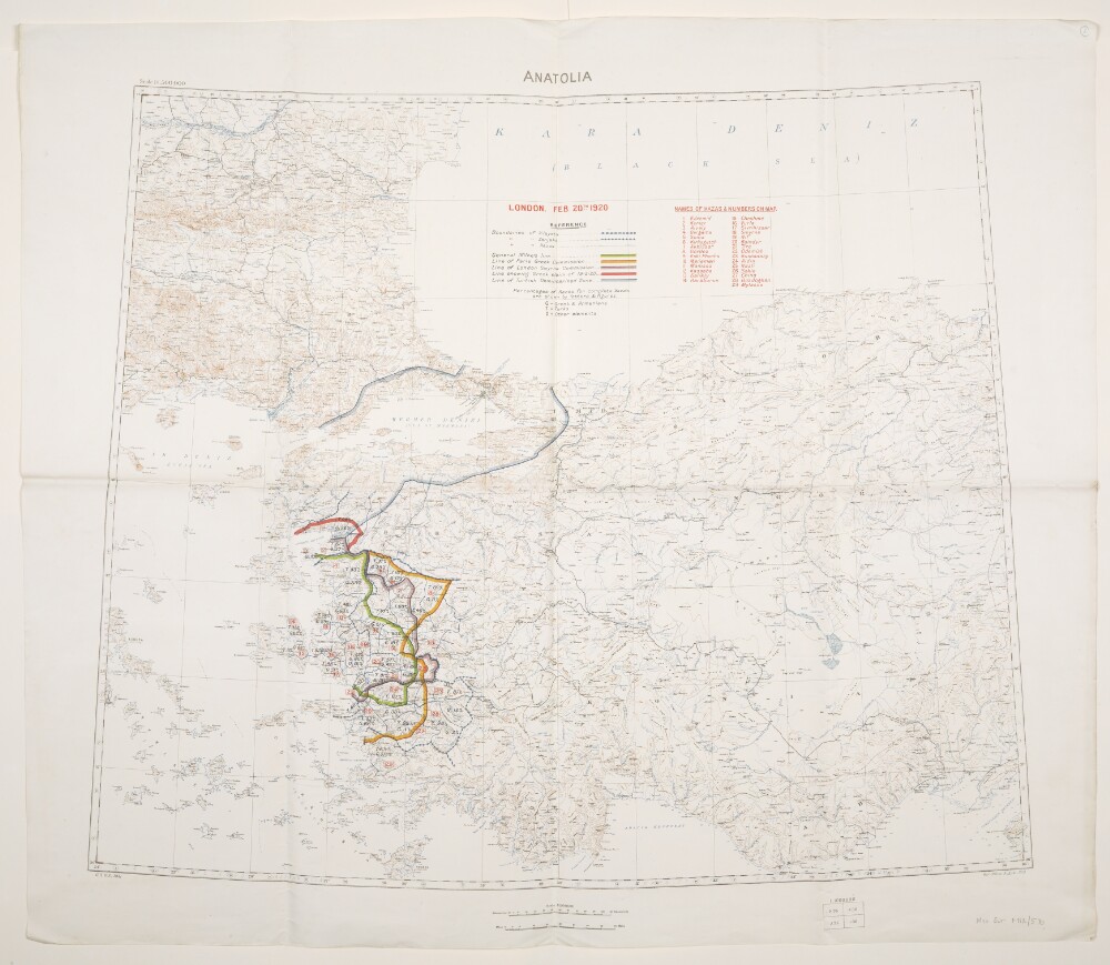
Abstract: Relates to the Treaty of Sèvres (1920)Created by the War Office August 1919 with boundaries added to 20 February 1920. Geographical Section, General Staff No. 2931, Sheet 'Anatolia'. Portrays hydrology, soundings, relief by spot heights and contours, railways, settlements, place names, and international and internal boundaries. Base map compiled from GSGS 2555 sheets NJ-35 (dated 1916), NJ-36 (1916), NK-35 (1919) and NK-36 (1916); projection information also derived from this source.Colour overprints, partly compiled from the information in folio 5, cover the Izmir (Smyrna) and Istambul [Istanbul] areas of western Turkey and depict boundaries of Vilayets, Sanjaks and Kazas; General Milne's Line; Line of Paris Greek Commission; Line of London Smyrna Commission; Line showing Greek claim of 19 February 1920; Line of Turkish Demilitarized Zone [Zone of the Straits]; and percentages of Races for complete Kazas, together with a list of Kazas.Verso bears the annotation 'Dardanelles'.Physical description: Materials: Printed in colour, with manuscript additions in pencilDimensions: 595 x 722mm, on sheet 713 x 830mm
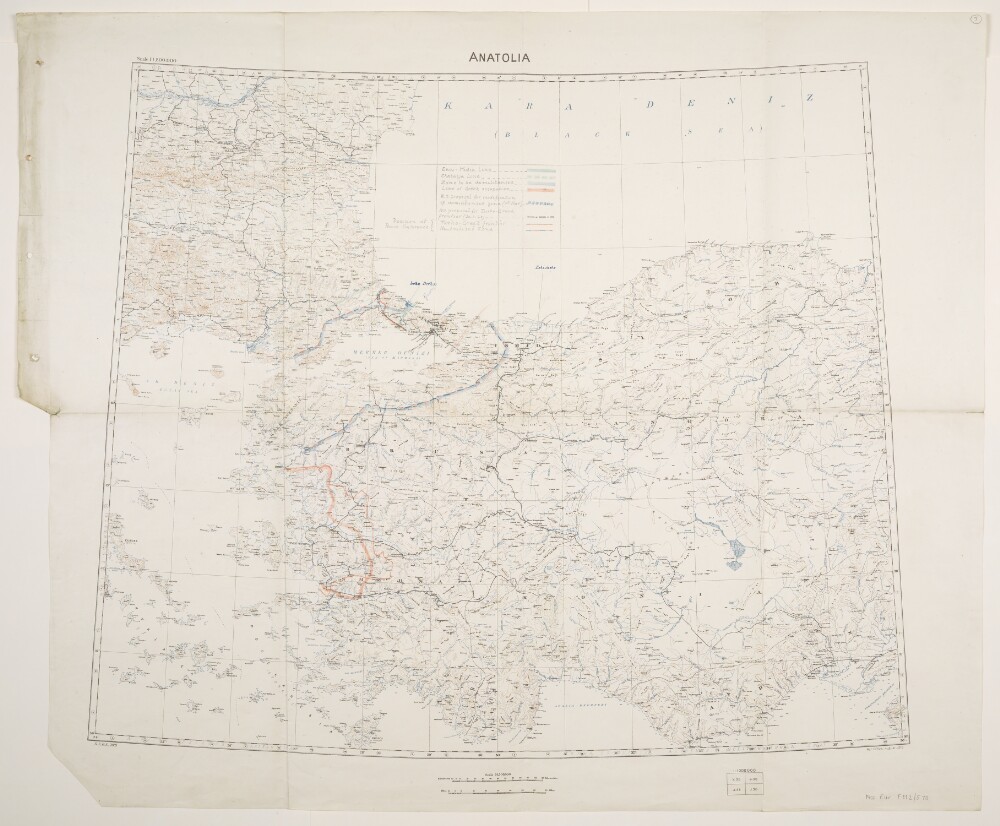
Abstract: Relates to the Treaty of Sèvres (1920).Created by the War Office August 1919 with boundaries and proposed boundaries added to 30 March 1920. Geographical Section, General Staff No. 2931, Sheet 'Anatolia'. Portrays hydrology, soundings, relief by spot heights and contours, railways, settlements, place names, and international and internal boundaries. Base map compiled from GSGS 2555 sheets NJ-35 (dated 1916), NJ-36 (1916), NK-35 (1919) and NK-36 (1916); projection information also derived from this source.Manuscript additions cover the Izmir (Smyrna) and Istambul [Istanbul] areas of western Turkey and depict the Enos-Midia Line; the Chatalja Line; the Zone to be demilitarised [Zone of the Straits]; the Line of Greek occupation; the W[ar]O[ffice] proposal for modification of demilitarised zone (11th March); the W[ar]O[ffice] proposal for Turko-Greek frontier (30 March 1920); the Turko-Greek frontier (as decided by Peace Conference); and the Neutralised Zone (as decided by Peace Conference). A small number of other features are also highlighted.Physical description: Materials: Printed in colour, with manuscript additions in pencil, crayon and coloured ink, on paperDimensions: 595 x 722mm, on sheet 713 x 860mm
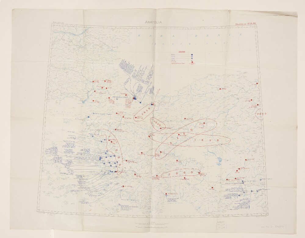
Abstract: Folio 7:Geographical Section, General Staff No. 2931, sheet 'Anatolia', comprising a base map with overprints.The base map bears the imprint 'War Office, November, 1919' and portrays hydrology, relief by spot heights, railways, settlements, place names, and internal and international boundaries. A contoured version of this base map is at Maps 47100.(24.).A blue overprint depicts the position of British, French, Greek and Italian troops as at 17 May 1920; a red overprint depicts the position of Turkish troops and Turkish Nationalist Bands.Folio 7a:Typescript note attached to the verso of Folio 7 reading:'Mr. Leigh. Sir John Tilley thinks Lord Curzon might like to see these Maps showing the present Military situation in Turkey. [Signed] ? C.S. Heather ? la Smith 3 June, 1920.'Typescript, with manuscript additions in ink. 210 x 84mm.Physical description: Materials: Printed in colourDimensions: 594 x 725mm, on sheet 709 x 913mm
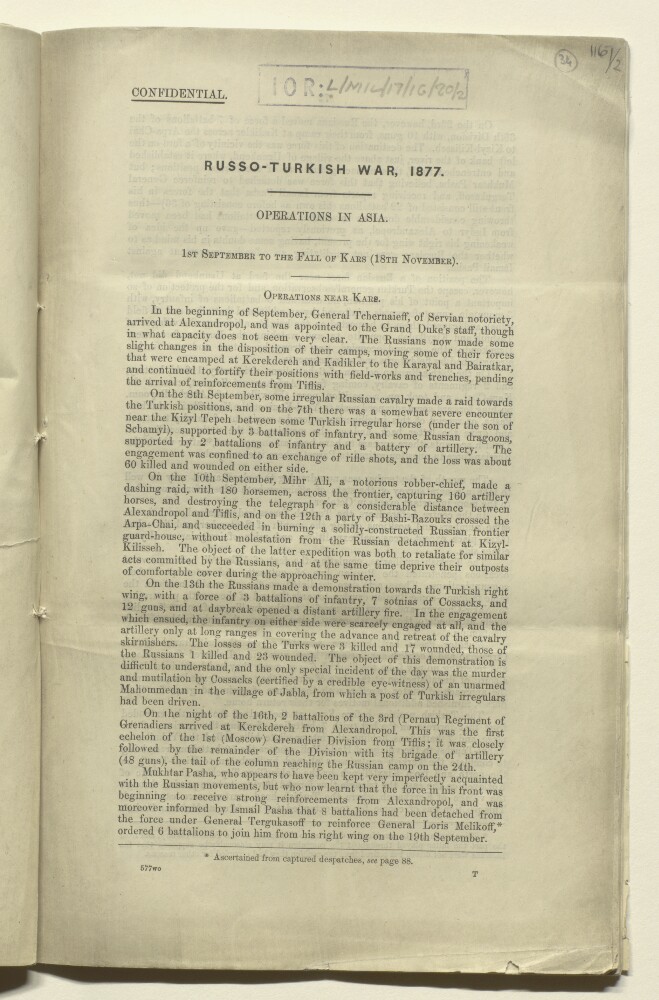
Abstract: Confidential report providing a narrative of operations in Asia (Turkey) during the Russo-Turkish War of 1877/78, written by Lieutenant W A H Hare, Royal Engineers. The narrative covers the period 1 September 1877 to the fall of the Turkish city of Kars on 18 November 1877. The narrative is followed by an
Ordre de Batailleof the Russian Army at the Battle of the Aladja Dagh, which took place on 15 October 1877.Physical description: 1 item (20 folios)
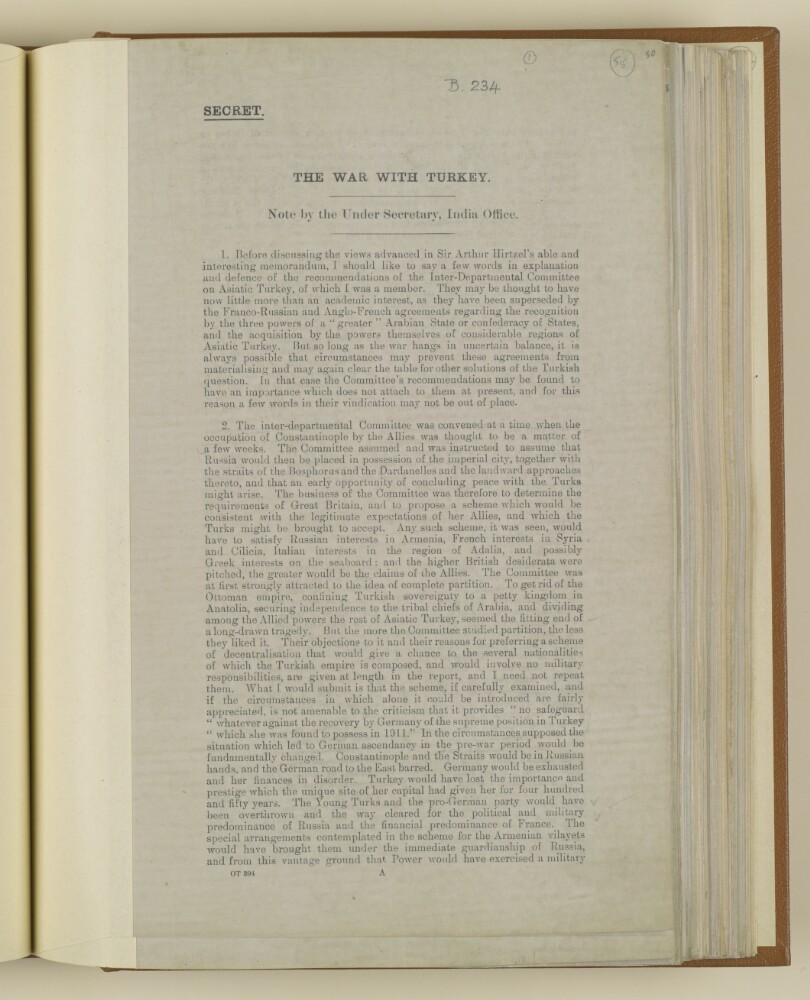
Abstract: Note written by Sir Thomas William Holderness, Under Secretary of State, India Office, in response to Sir Arthur Hirtzel's memorandum on the war with Turkey (IOR/L/PS/18/B233).The note describes the recommendations of the Inter-Department Committee on Asiatic Turkey, which Sir Thomas Holderness was a member of, and which were based on the assumption by the Committee at the time of its convening that an allied occupation of Constantinople was only weeks away, that Russia would be in possession of the city and surrounding areas and that peace with the Turks would be possible.The committee's responsibility, in light of the assumptions, was as follows:To propose a scheme for Asiatic Turkey that would satisfy Russian, French, Italian and Greek interests in the region and which would suit the needs and requirements of Great Britain; possibilities included the complete partition of the region; the removal of the Ottoman Empire; and decentralisation of Turkey without the need for military intervention.The note goes on to consider potential concerns over German power and influence in Turkey; the dangers of any settlement with Turkey that would not include the ending of the Ottoman Empire; the risks from Germany gaining control of the Balkan States; the danger of pan-Islamism; the possibilities of British interests in the East being achieved if Germany is defeated and Turkey collapses as a military power; and the Mesopotamian Campaign and its development as a serious military operation.Physical description: Foliation: The foliation for this description commences at folio 55 and terminates at folio 57, as it is part of a larger physical volume; these numbers are written in pencil, are circled, and are located in the top right corner of the recto side of each folio. An additional foliation sequence is also present in parallel between folios 6-153; these numbers are also written in pencil, but are not circled, and can be found in the same position as the main sequence.
Abstract: Memorandum, written by Sir Frederic Arthur Hirtzel, dated 25 May 1916, examining the implications of war with Turkey on Great Britain particularly the importance to Germany of a Turco-Ottoman alliance and the integrity of the Ottoman Empire, and the corresponding importance of its dissolution to Great Britain.The memorandum discusses Germany's need for raw materials and its realisation that supplies from Asiatic Turkey may take years to establish; the German threat to the Suez Canal and the Dardanelles; the threat to India from Mesopotamia; the dangers of Pan-islamism; the potential risks of waging war on a Moslem [Muslim] power, particularly given British relations in the Persian Gulf; and the possible outcomes of the war with Germany and the likely position of Turkey in relation to them.Enclosed with the memorandum are two appendices:Appendix I: Extract from an article by Dr Hans Delbrück in the
Schwäbische Merkur17 May 1916, summarising the German ideal of 'weltpolitik' (world policy);Appendix II: Extract memorandum by Sir Mark Sykes on "The problem of the Near East", dated 20 June 1916.Sir Frederic Arthur Hirtzel is not named on the memorandum as its author, however IOR/L/PS/18/B234 refers to him as its author.Physical description: Foliation: The foliation for this description commences at folio 51 and terminates at folio 54, as it is part of a larger physical volume; these numbers are written in pencil, are circled, and are located in the top right corner of the recto side of each folio. An additional foliation sequence is also present in the volume; these numbers are also written in pencil, but are not circled, and can be found in the same position as the main sequence.
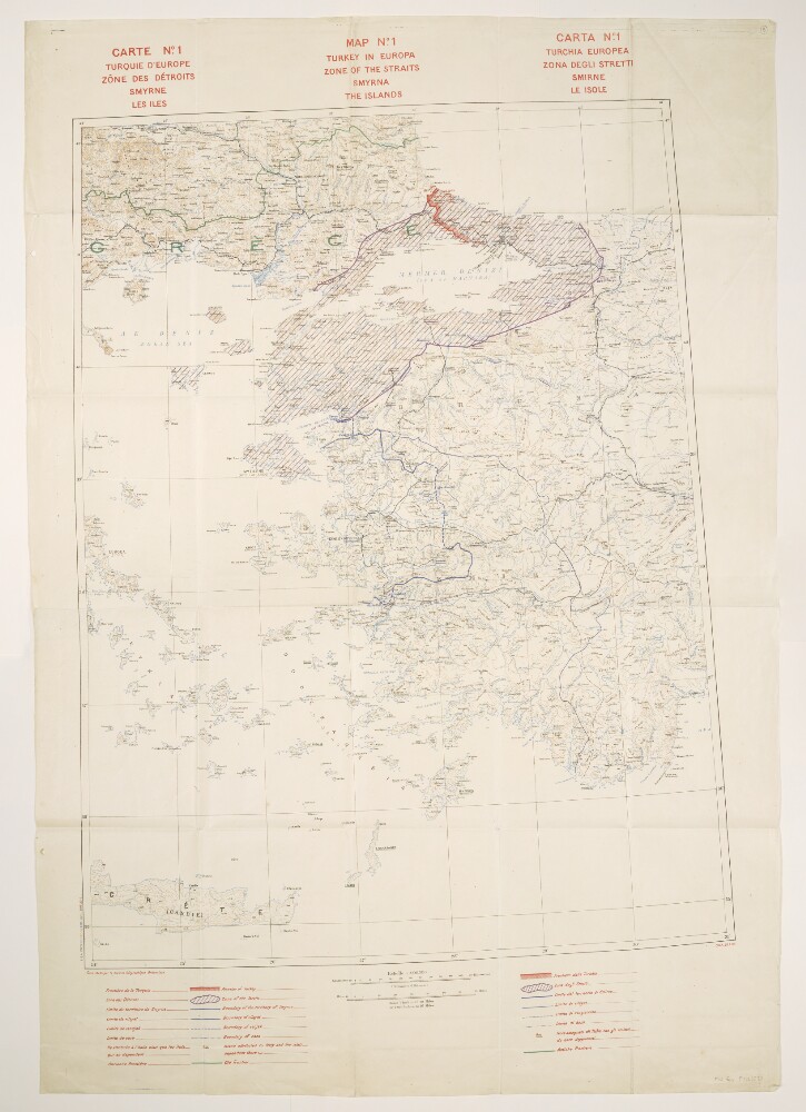
Abstract: Title also given in French (
Carte No. 1. Turquie d’Europe, Zône des Détroits, Smyrne, les Iles) and Italian (
Carta No. 1. Turchia Europea. Zona degli Stretti, Smirne, Le Isole).Relates to the Treaty of Sèvres (1920).Comprises a base map and overprints, and covers an area within an approximately 240-mile radius of Smyrna [Izmir] in western Turkey and extending north-westwards into Greece.The base map portrays hydrology, soundings, relief by spot heights and contours, railways, settlements, post and telegraph offices, place names, and international and internal boundaries. Bears the French imprint
Fond établi par le Service Géographique Britannique[Base map established by the British [army] Geographical Section]. North of 36⁰N the base is compiled from GSGS 2555 sheets NJ-35 (dated 1916), NJ-36 (1916), NK-35 (1919) and NK-36 (1916); south of this, map detail is coarser. Projection information is also derived from GSGS 2555.Colour overprints portray the Turkish border, Zone of the Straits, Smyrna Enclave, boundaries of vilayets, sanjaks and casas, islands attributed to Italy and the former frontier. Overprint legend in English, French and Italian. Bears the imprint
S[ervice].G[éographique de l']A[rmée]. 28 7.20.The verso bears the annotation 'Straits'.Physical description: Materials: Printed in colourDimensions: 830 x 633mm, on sheet 1070 x 745mm
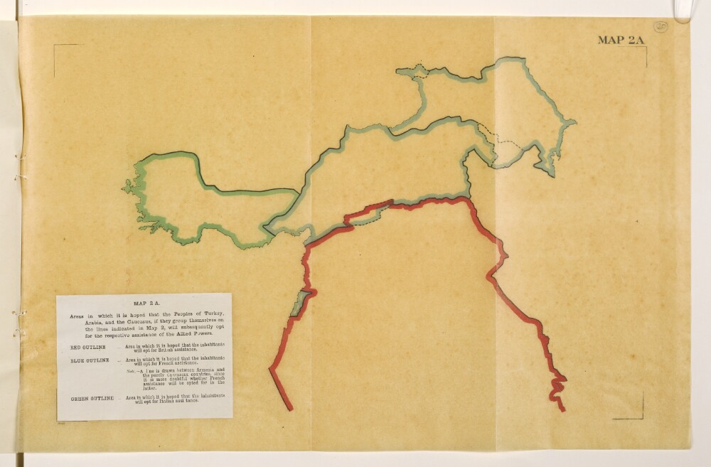
Abstract: Map is an overlay to Mss Eur F112/570, f 21 and forms a part of Mss Eur F112/570, ff 17-23.The title and legend are printed on a small paper sheet that has been pasted over the south-west corner of the map. Map portrays, by variously coloured boundaries, areas in which it is 'hoped that the inhabitants will opt for [British, French or Italian] assistance'. Bears the imprint '8146.' [Published by the Political Intelligence Department, Foreign Office, 21 November 1918.]Another copy of this map is at Mss Eur F112/570, f 27.Physical description: Materials: Printed in colour on tracing paperDimensions: 243 x 393mm, on sheet 290 x 450mm