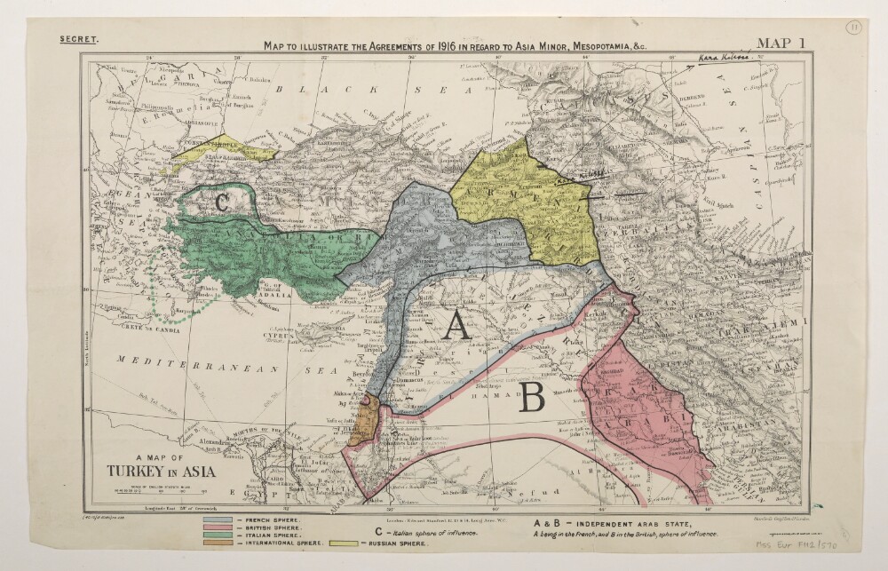
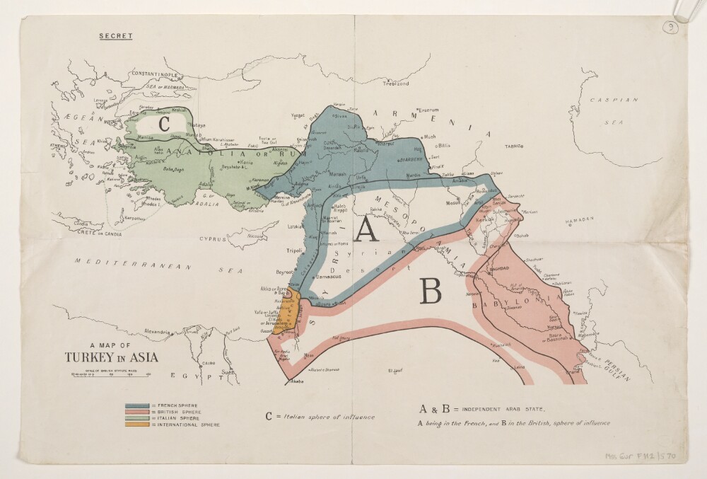
Abstract: Classified 'Secret'.The map bears a secondary title 'A Map of Turkey in Asia'.Bears the printed designation 'Map 1'. Depicts a proposed division of the Ottoman Empire into spheres of influence and protection by the Allied powers. The division is based on agreements reached between 1916 and the end of the First World War. Portrays hydrology, relief by spot heights and hachures, roads and tracks, railways, submarine telegraph lines, settlements, place names and international boundaries. A black overprint combined with watercolour washes show French, British, Italian, Russian and International spheres of influence, including provision for an independent Arab state within the French and British spheres. Some place names have been highlighted in manuscript.The base map bears the imprint 'London: Edward Stanford, 12, 13 & 14, Long Acre, W.C.' The printer's imprint 'Harrison & Sons, Lith. St. Martins Lane, W.C.' and print code '(40.10/18.6360)F[oreign].O[ffice].238.' have been added later.Verso bears an undetermined annotation.Physical description: Materials: Printed in colour, with additions in watercolour, ink and crayonDimensions: 243 x 388mm, on sheet 286 x 449mm
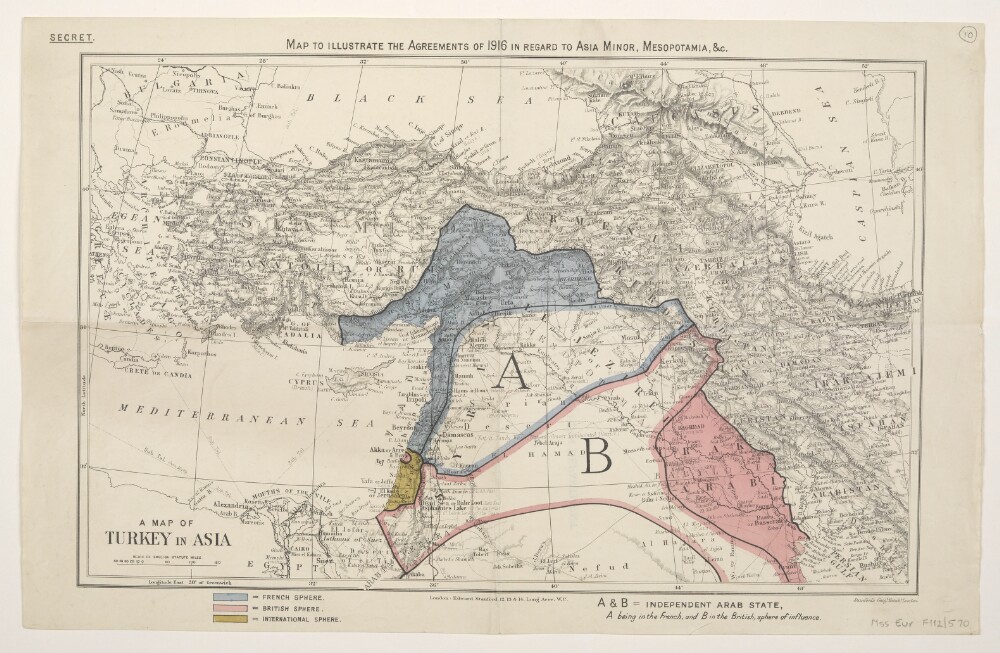
Abstract: Classified 'Secret'.The map bears a secondary title 'A Map of Turkey in Asia'.Depicts a proposed division of the Ottoman Empire into spheres of influence and protection by the Allied powers. The division is based on agreements reached between 1916 and the end of the First World War. Portrays hydrology, relief by spot heights and hachures, roads and tracks, railways, submarine telegraph lines, settlements, place names and international boundaries. A black overprint combined with watercolour washes show French, British and International spheres of influence, including provision for an independent Arab state within the French and British spheres.The base map bears the imprint 'London: Edward Stanford, 12, 13 & 14, Long Acre, W.C.'Verso bears the annotation '2nn' [?] and the stamp 'Eastern Department'.Physical description: Materials: Printed in colour, with additions in watercolour, pencil and rubber stampDimensions: 243 x 388mm, on sheet 284 x 447mm
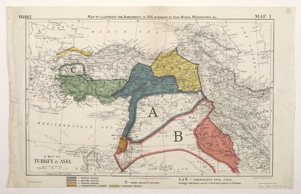
Abstract: Three identical map sheets.Classified 'Secret'.The map bears a secondary title 'A Map of Turkey in Asia'.Bears the printed designation 'Map 1'. Depicts a proposed division of the Ottoman Empire into spheres of influence and protection by the Allied powers. The division is based on agreements reached between 1916 and 1919. Portrays hydrology, relief by spot heights and hachures, roads and tracks, railways, submarine telegraph lines, settlements, place names and international boundaries. Various blocks of overprinted colour shading correspond to French, British, Italian, Russian and International spheres of influence, including provision for an independent Arab state within the French and British spheres.The base map bears the imprint 'London: Edward Stanford, 12, 13 & 14, Long Acre, W.C.' The printer's imprint 'Harrison & Sons, Lith. St. Martins Lane, W.C.' and print code '(350.1/19.6648) F[oreign].O[ffice].' have been added later.Folio 14 has manuscript boundary additions in pencil and crayon.Physical description: Materials: Printed in colour, with manuscript additions in pencil and crayonDimensions: 243 x 388mm, on sheet 289 x 452mm
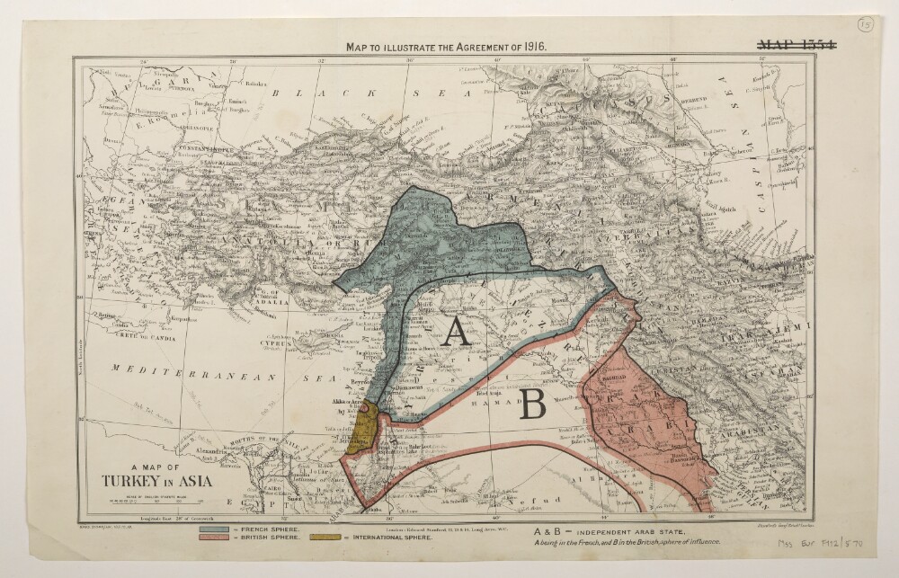
Abstract: Two identical map sheets.The map bears a secondary title 'A Map of Turkey in Asia'.Bears the deleted designation 'Map 1354'. Depicts a proposed division of the Ottoman Empire into spheres of influence and protection by the Allied powers. The division is based on agreements reached between 1916 and 1919. Portrays hydrology, relief by spot heights and hachures, roads and tracks, railways, submarine telegraph lines, settlements, place names and international boundaries. Various blocks of overprinted colour shading correspond to French, British and International spheres of influence, including provision for an independent Arab state within the French and British spheres.The base map bears the imprint 'London: Edward Stanford, 12, 13 & 14, Long Acre, W.C.' The print code '8995.21848./131.135.10.19.' has been added later.The verso of folio 15 bears the annotation 'SP'.Physical description: Materials: Printed in colourDimensions: 243 x 388mm, on sheet 289 x 452mm
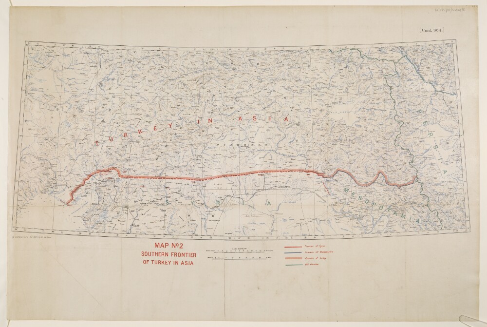
Abstract: This map shows Turkey where it is included in Asia and indicates the boundaries between Turkey, Syria, Mesopotamia and the Old Frontier. The map also indicates relief with contours.The map includes a printing statement which reads '(B 16479) WT 18378-212.5050.10/20.H&S,LTD.'Physical description: Materials: Printed in colour on paper with manuscript additions in coloured inkDimensions: 310x 733mm, on sheet 505 x 759mm
Abstract: Classified 'Secret'.Depicts a proposed division of the Ottoman Empire into spheres of influence and protection by the Allied powers. The division is based on agreements reached between 1916 and the end of the First World War. Portrays hydrology, settlements and place names. Various blocks of overprinted colour shading correspond to French, British, Italian and International spheres of influence, including provision for an independent Arab state within the French and British spheres.Physical description: Materials: Printed in colourDimensions: 230 x 376mm, on sheet 281 x 416mm
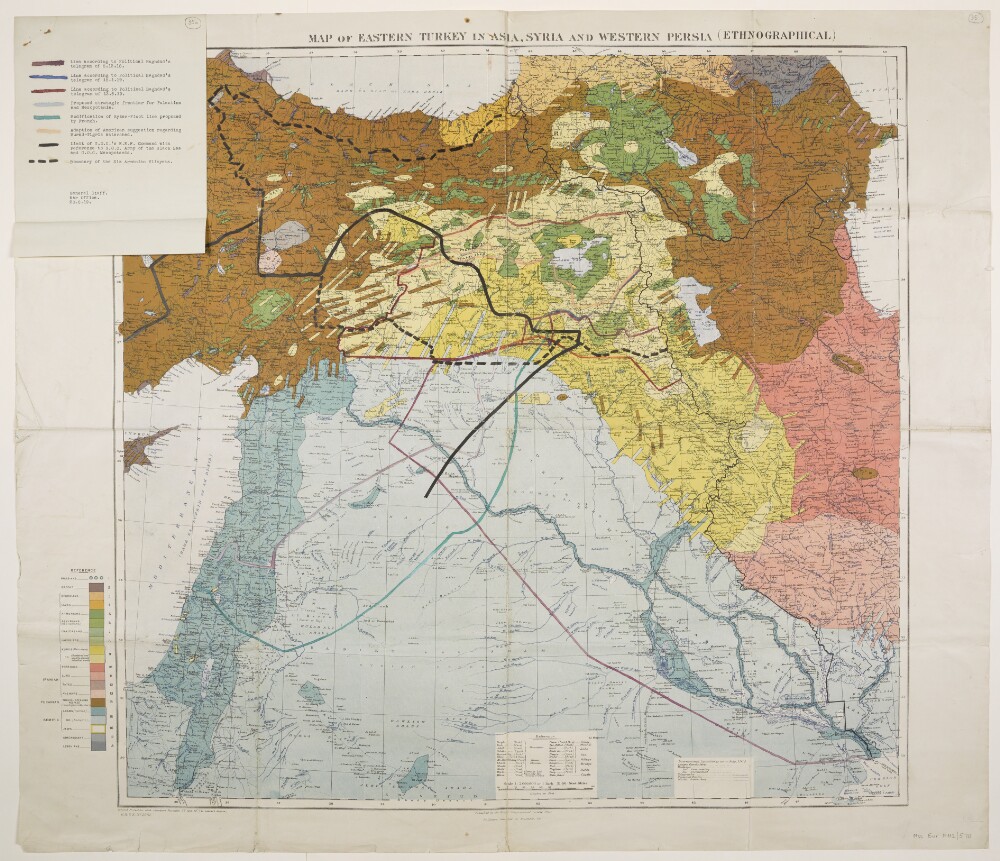
Abstract: Folio 35 is a map bearing the imprint 'Published by the Royal Geographical Society, 1910. Railways inserted to November, 1917' and the series designation 'G[eographical].S[ection].,G[eneral].S[taff]., No. 2901.' Portrays hydrology, roads, telegraphs, settlements, place names and international boundaries. The sheet bears the printed note 'International Boundaries as in July, 1914'. A 1921 full edition of this base map, including also relief, railways and ancient canals, is at Maps 46970.(44.) although lacks a GSGS designation, yet includes a set of accompanying notes published by the Royal Geographical Society in 1910, including details of compilation material.A thematic overprint in several colours portrays the geographical distribution of twenty different ethnographical groups. Eight proposed boundaries have been added in manuscript. Copies of this map, without the manuscript additions, are also filed at Maps 46990.(1.) and Maps MOD GSGS 2901.Folio 35a is an attached folio (227 x 181mm) in typescript and coloured ink that provides a key to the manuscript boundary additions on folio 35. It bears the signature block 'General Staff. War Office. 20.8.19.'Physical description: Materials: Printed in colour, with manuscript additions in coloured inkDimensions: 710 x 743mm, on sheet 785 x 912mm
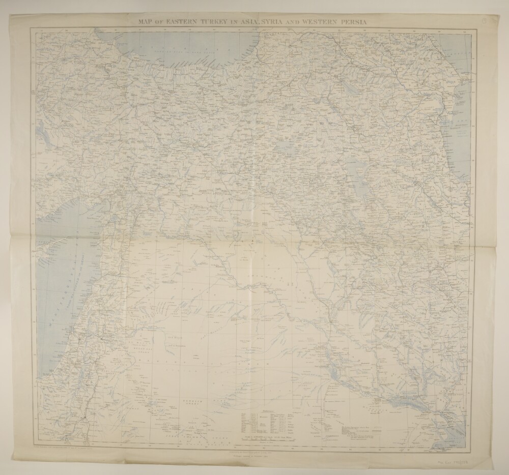
Abstract: Bears the imprint 'Published by the Royal Geographical Society, 1910. Railways inserted to November, 1915'. Portrays hydrology, relief by spot heights, roads, railways, telegraphs, settlements, place names and international boundaries. Manuscript annotations highlight four sites on the Hejaz railway in Palestine. Creation end date derived from documented British military activity along this section of the railway.The verso bears the annotation 'Mesopotamia & Palestine'.A 1917 edition of this map, additionally portraying relief by hachures and ancient canals, accompanied by a set of explanatory notes including details of compilation material, published by the Royal Geographical Society in 1910, is held at Maps 203.e.20.Physical description: Materials: Printed in colour, with manuscript additions in pencilDimensions: 710 x 733mm, on sheet 760 x 812mm
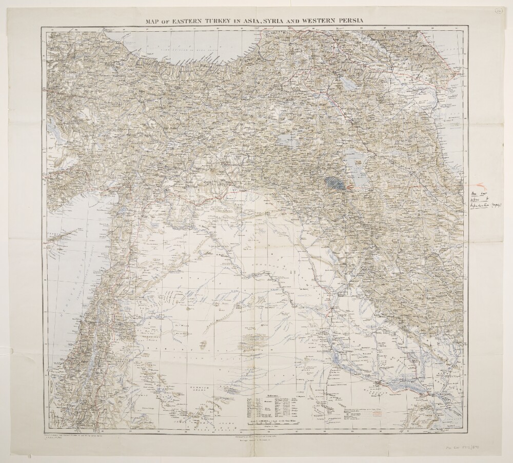
Abstract: Bears the imprint 'Published by the Royal Geographical Society, 1910. Railways inserted to November, 1917' and the series designation 'G[eographical].S[ection].,G[eneral].S[taff]., No. 2901.' Portrays hydrology, relief by spot heights and hachures, roads, railways, telegraphs, settlements, ancient canals, place names and international boundaries. The sheet bears the printed note 'International Boundaries as in July, 1914'. A 1921 edition of this base map is at Maps 46970.(44.) although lacks a GSGS designation, yet includes a set of accompanying notes published by the Royal Geographical Society in 1910, including details of compilation material.A manuscript annotation depicts an 'Area now proposed for Repatriation. (?From July)'.Verso bears the manuscript annotation 'Map of Eastern Turkey in Asia, Syria & W. Persia [Iran]'.Physical description: Materials: Printed in colour, with manuscript additions in ink and crayonDimensions: 710 x 745mm, on sheet 789 x 860mm
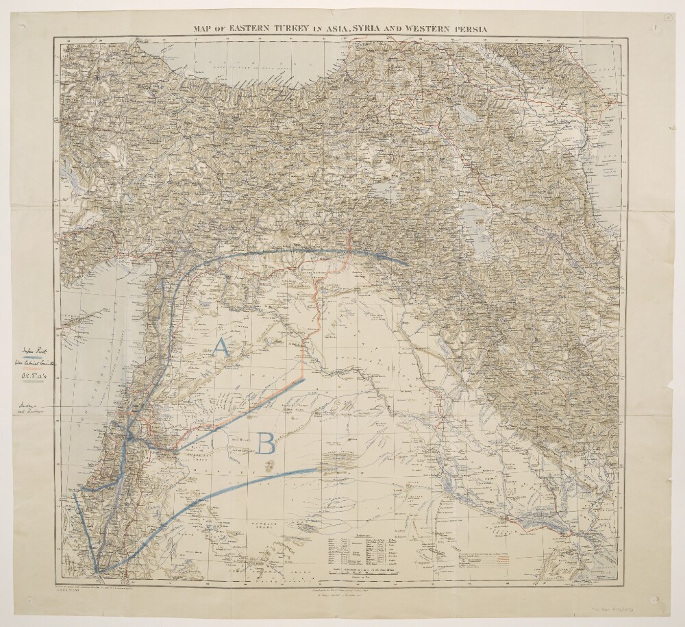
Abstract: Bears the imprint 'Published by the Royal Geographical Society, 1910. Railways inserted to November, 1917' and the series designation 'G[eographical].S[ection].,G[eneral].S[taff]., No. 2901.' Portrays hydrology, relief by spot heights and hachures, roads, railways, telegraphs, settlements, ancient canals, place names and international boundaries. The sheet bears the printed note 'International Boundaries as in July, 1914'. A 1921 edition of this base map is at Maps 46970.(44.) although lacks a GSGS designation, yet includes a set of accompanying notes published by the Royal Geographical Society in 1910, including details of compilation material.Manuscript annotations depict proposed boundaries by Sykes-Picot, the War Cabinet Committee and 'O[ttoman?].E[mpire?].[F?].A's.', and highlight two villages.Verso bears the manuscript annotation 'Asia Minor'.Physical description: Materials: Printed in colour, with manuscript additions in ink, pencil and crayonDimensions: 710 x 745mm, on sheet 789 x 860mm
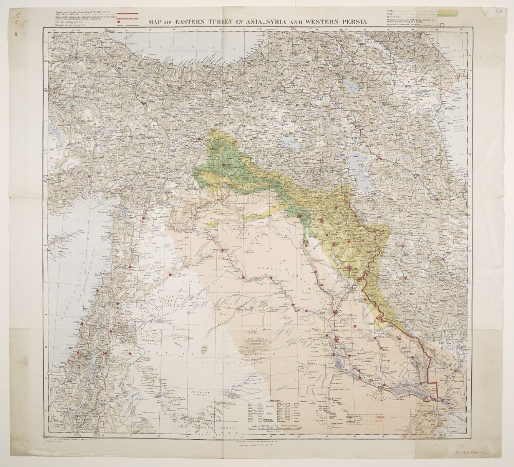
Abstract: Folios 33 and 34 are copies of the same map.Bears the imprint 'Published by the Royal Geographical Society, 1910. Railways inserted to November, 1917' and the series designation 'G[eographical].S[ection].,G[eneral].S[taff]., No. 2901.' Portrays hydrology, relief by spot heights and hachures, roads, railways, telegraphs, settlements, ancient canals, place names and international boundaries. The sheet bears the printed note 'International Boundaries as in July, 1914'. A 1921 edition of this base map is at Maps 46970.(44.) although lacks a GSGS designation, yet includes a set of accompanying notes published by the Royal Geographical Society in 1910, including details of compilation material.Coloured overprints depict areas of 'Kurds', 'Arabs', 'Mixed Races' and 'debateable lands between Arabs and Kurds'; possible boundaries for Mesopotamia; aircraft landing-grounds and railways; and proposed permanent garrisons.Physical description: Materials: Printed in colourDimensions: 612 x 745mm, on sheet 780 x 860mm
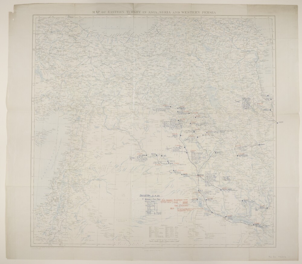
Abstract: Three copies of map sheet Geographical Section, General Staff No. 2901, comprising a base map with overprints.The base map bears the imprint 'Published by the Royal Geographical Society, 1910. Railways inserted to November, 1917' and portrays hydrology, relief by spot heights, roads, telegraphs, settlements, place names and international boundaries. The sheets bear the printed note 'International Boundaries as in July, 1914'. A 1921 edition of this base map is at Maps 46970.(44.) and includes accompanying notes (including compilation details) published by the Royal Geographical Society in 1910, although lacks a GSGS designation yet contains an additional red plate (railways) and grey plate (hachures and ancient canals) that are both lacking from this version.Overprints in red and blue depict the disposition of British and Indian troops as at 7 April 1920 and the cost per annum of maintaining them, and railway routes radiating from Bagdad.Folio 4 also contains line features [routes or boundaries?] added as pencil annotations.Physical description: Materials: Printed in colour, with manuscript additions in pencilDimensions: 693 x 728mm, on sheet 789 x 887mm