Abstract: The volume contains letters, telegrams, memoranda and reports pertaining to British governmental representation in Arabistan [Khūzestān]. The correspondents include the Political Resident at Bushire, the British Minister at Tehran, the High Commissioner at Baghdad, the British Consul at Mohammerah [Korramshahr], the Vice-Consuls at Ahwaz and Dizful, the Government of India, the India Office and Foreign Office in London, and the Anglo-Persian Oil Company.The correspondence was part of a re-evaluation of British representation and expenses in the region following the First World War. The issues discussed included:the political status (consul, vice-consul, agent or officer) of offices at Mohammerah, Ahwaz, Dizful, Shushtar, and Burujird [Borūjerd], and whether the responsibility for these offices should be transferred from Mesopotamia (under the Foreign and Colonial Offices) to the Government of India;the hierarchy of operations (who answers to whom) within Arabistan itself;the scale of operations, including details of costs and salaries;the official change of name from Arabistan to Khuzestan.Physical description: Foliation: The main foliation sequence commences at the first folio and terminates at the last folio; these numbers are written in pencil, are circled, and can be found in the top right corner of the recto side of each folio. A second foliation sequence is present between ff 3-229; these numbers are also written in pencil, but are not circled, and can be found in the same position as the main sequence. There are the following irregularities: 2, 2A and 2B.
Abstract: The memorandum consists of a report of Walter Baring's journey from Ispahan [Eşfahān] to Shuster [Shūshtar], Dizful [Dezfūl], Behbehan [Behbehān], and Shiraz; he was accompanied on this journey by Captain H Wells, Royal Engineers, and the Assistant Superintendent of the Indian Government Telegraph. This journey took place between 27 October and 16 December 1881.The report includes observations on local cultivation, the local economy, geography, water quality, and wild life. From time to time it also includes information on local history, political intrigues, and local tribes (especially the Bakhtyari [Bakhtiari] tribe). It also reports on the daily weather conditions and the quality of the roads being traversed.The appendix which can be found on folios 152-153 contains the following:a tabular statement of the revenue of Fars (f 152);a list of the altitudes of principal points mentioned in the report (f 152);a list of the distances of the various stages between Ahwaz and Shiraz (f 152v);a memorandum concerning Mr Baring's observations on opium cultivation during the course of his journey (f 153).Physical description: Foliation: the foliation sequence commences at f 140 and terminates at f 153, as it is part of a larger physical volume; these numbers are written in pencil, and are located in the top right corner of the recto side of each folio. Pagination: the item also contains an original printed pagination sequence.
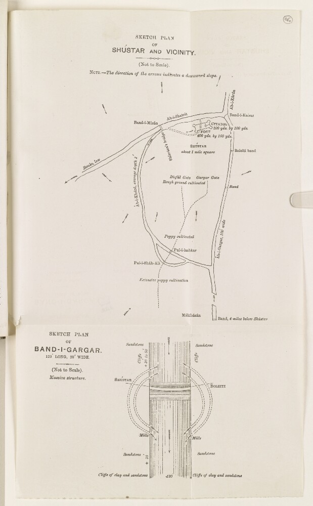
Abstract: Diagrammatic map of the Band-i-Gargar embankment, part of the Shūshtar historical hydraulic system, showing: the direction of the canal’s flow; water channels; the location of mills; clay and sandstone cliffs; the locations of Shūshtar, on one bank, and the village of Boleiti on the other.Physical description: Dimensions: 105 x 150 mm, on sheet 344 x 202 mm.Materials: Printed on paper.
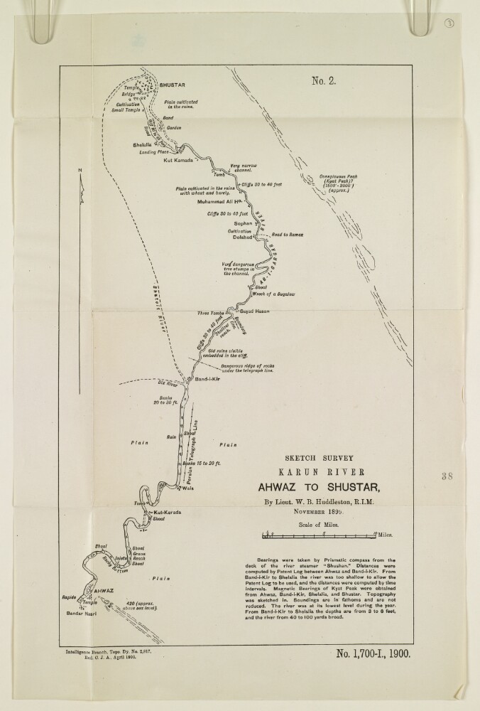
Abstract: The sketch map shows the course of the river Karun from Ahwaz [Ahvāz] to Shushtar, based on a survey undertaken by Lieutenant Willoughby Baynes Huddleston of the Royal Indian Marine in November 1899. The map indicates: the course and nature of the river; soundings, measured in fathoms; the height of banks, shoals; channel hazards; plains; notable landmarks; roads; and river tributaries. A note below the map title states that the bearings were taken by prismatic compass from the deck of the river steamer
Shushtan, at a time of year when the river was at its lowest annual point. The note gives further information on the methods used to record river measurements and bearings.Other labels on the map: at the top, ‘No. 2’; at the bottom: ‘Exd C.J.A.’Physical description: Dimensions: 354 x 217 mm, on sheet 419 x 275 mm.Materials: Printed on paper.
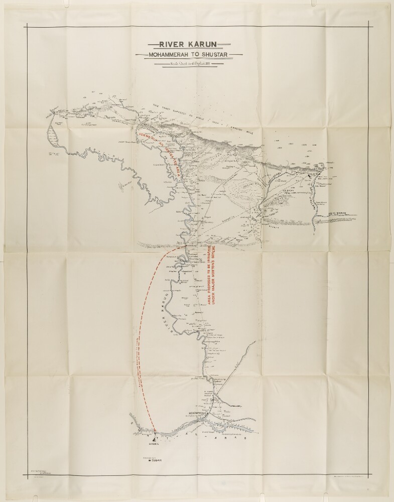
Abstract: This map records the path of the River Karun from Mohammerah to Shushtar. Place names bordering the river are included without additional details.'M.A. Hakimkhan Draftsman’ is printed in the bottom left hand corner below the neat line.This map was heliozincographed at the Survey of India Office, Calcutta.Physical description: Materials: Printed in colour on paperDimensions: 1120 x 840mm