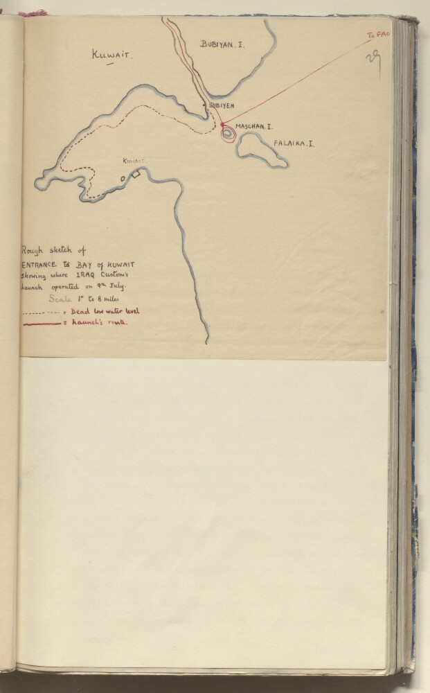
Abstract: Distinctive Features:An outlined hand drawn map of the Kuwait Bay enclosed with a letter no. C-241 from Harold Richard Patrick Dickson, Political Agent, Kuwait, dated 25th July 1935 (folios 26-28). Produced to illustrate an incident of violation of Kuwait territorial waters by Iraq customs launch with launch’s route show in red ink and low water levels marked.Physical description: Materials:Pen and ink with crayon on tracing paperDimensions:329 x 185 mm
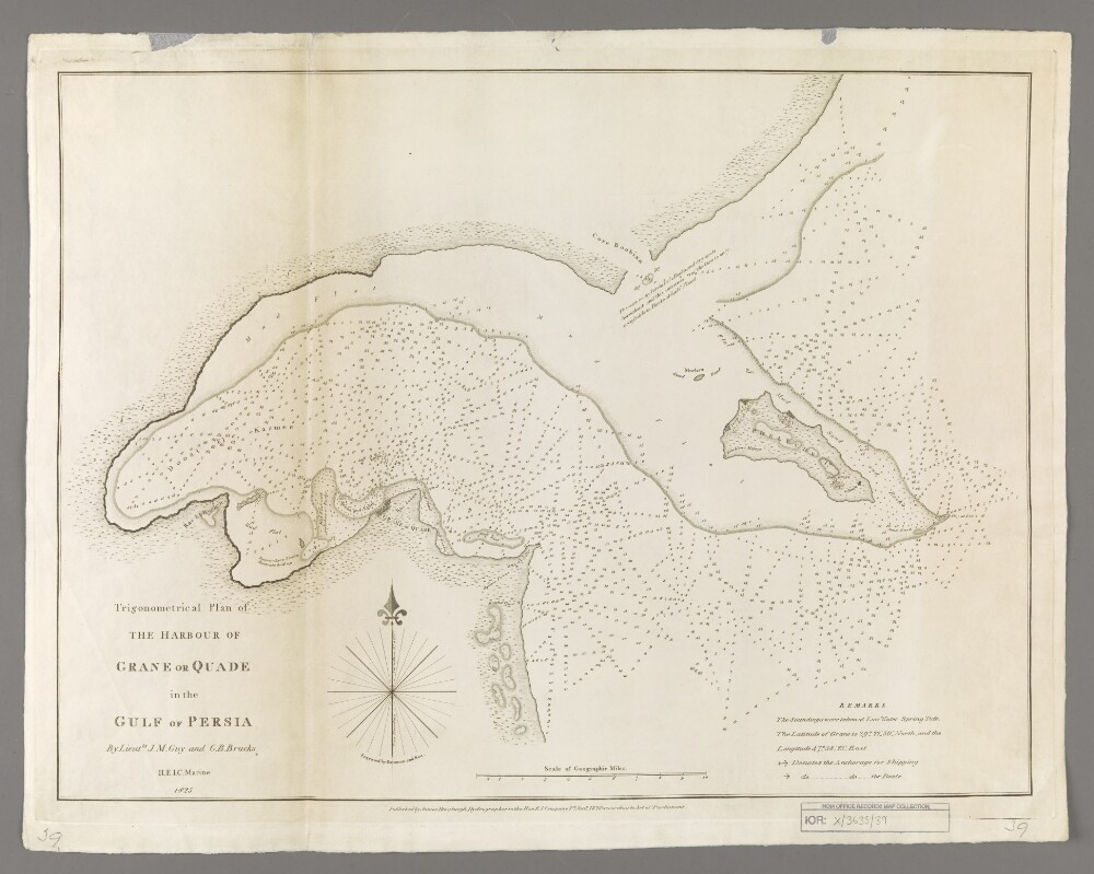
Abstract: Covers Grane [Kuwait] and surrounding coastline and waters of Kuwait Bay. Portrays hydrology, including depths by soundings, sands, muds, rocks and anchorages, relief by hachures, vegetation, settlements and place names, and includes topographical and hydrographic notes.Surveyed by Lieutenants John Michael Guy and George Barnes Brucks, 1825. Engraved by Bateman and Son. Published by James Horsburgh, Hydrographer to the Honourable East India Company.Physical description: Materials: Printed on paperDimensions: 385 x 515mm, on sheet 437 x 557mm
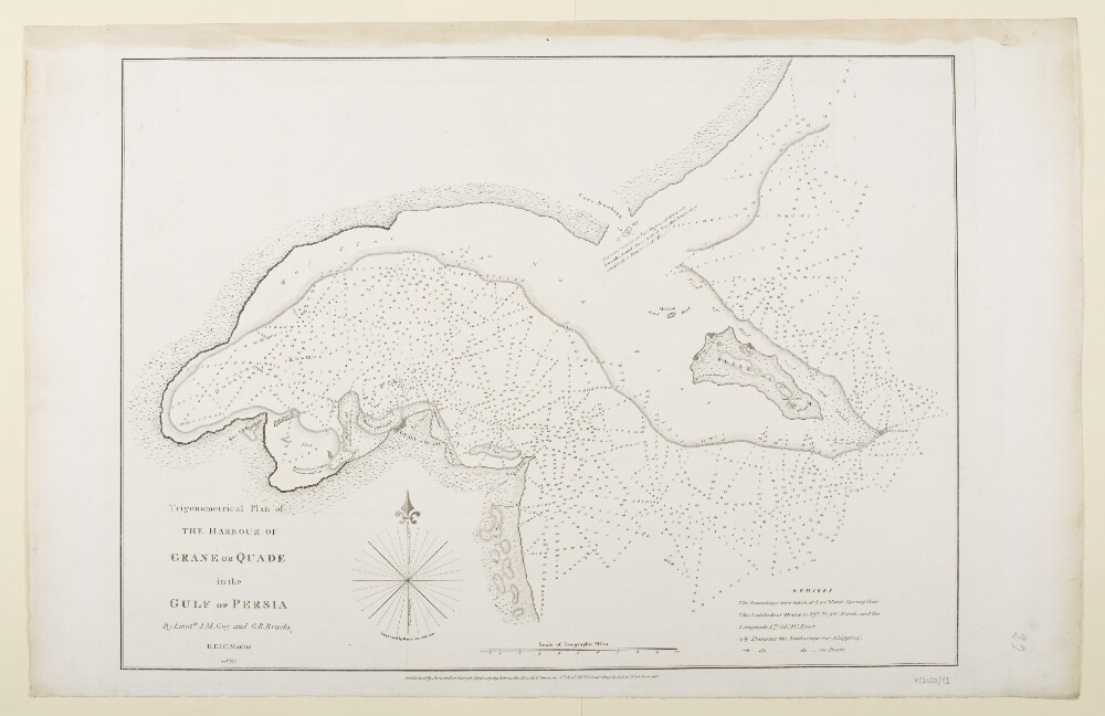
Abstract: Imprint:Published by James Horsburgh, Hydrographer to the East India Company.Distinctive Features:Depth shown by soundings.Nautical chart of the coast of the Kuwait Bay compiled from the surveys carried out by the Bombay Marine’s officers between 1820 and 1829.Depicts positions for safe anchorage for shipping and boats. Contains a key and a note reporting the longitude of Grane in the lower right-hand corner.Physical description: Dimensions:387 x 531 mm, on sheet 431 x 674 mm
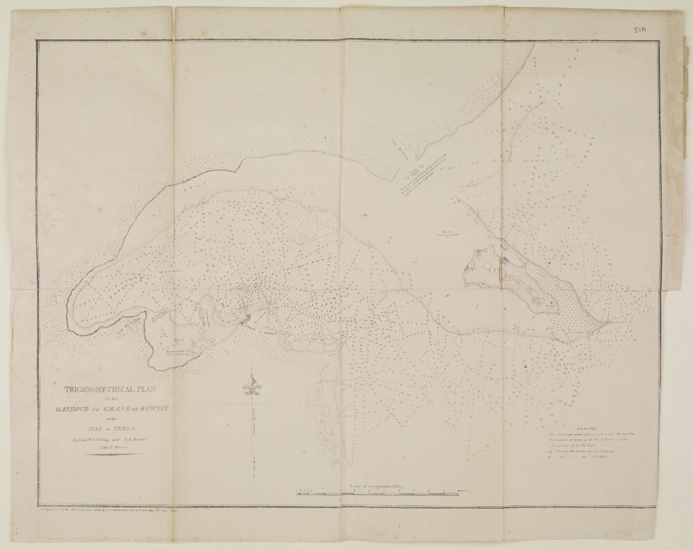
Abstract: Imprint:Lithographed in the Chief Engineer’s Office by G. Luxumonjee and K, E. Bombay, 6th Sept.r 1855.Distinctive Features:Produced to accompany a report on the Harbour of Grane (or Koweit), and the Island of Pheleechi, prepared by Lieutenant J. Felix Jones, Indian Navy.Depth shown by detailed soundings in fathoms. Mud flats, areas partly dry at low water indicated with anchorage for shipping and boats marked. Includes an explanatory note at the bottom right-hand corner.Physical description: Dimensions:382 x 513 mm, on sheet 444 x 558 mm
Abstract: Imprint:Published by Col. Chesney. Engraved by J.&C. Walker.Distinctive Features:Relief shown by hachures.Depths shown by soundings recorded in fathoms.Published as a part of a survey, above title ‘XII’ relates to sheet number.Physical description: Dimensions:470 x 640 mm, on sheet 511 x 656 mm
Abstract: The file concerns the question of whether Kuwait Bay (also referrred to in the papers as Koweit Bay) was an historic bay (or territorial inlet) [an area of water over which a coastal state has asserted soverignty over a long period of time, and with the acquiescence of other nations], and the precise extent of Kuwait's territorial waters. The issue arose from an enquiry raised with the India Office by the Kuwait Oil Company in 1940 about how to settle details of oil concessions, but which had not been investigated fully because of the intervention of World War Two. The file contains correspondence on the subject between the India Office, the Ministry of Fuel and Power, the Admiralty, the Foreign Office, the Political Resident in the Persian Gulf, the Political Agent, Bahrain, and the Political Agent, Kuwait, July 1946 - July 1947 (including reference to the issue of ownership of the seabed under international law for the purposes of extracting oil, and discussion of the ways in which the Sheikh of Kuwait could assert his title to the bay); and resultant correspondence in Arabic and English between the Political Agent, Kuwait (Major Maurice Patrick O'Connor Tandy) and the Ruler of Kuwait (Sheikh Sir Ahmed al Jabir As-Subah) containing a request from the Agency that the Ruler inform the Kuwait Oil Company in writing that the territory of the State of Kuwait included Kuwait Bay, as defined within precise maritime co-ordinates, July 1947.Physical description: Foliation: the foliation system in use commences at 1 on the front cover, and continues through to 19 on the back cover. The sequence is written in pencil and appears in the top right hand corner of the recto page of each folio. Foliation anomalies: ff. 1, 1A, 1B. The following folio needs to be folded out to be read: f. 7.
Abstract: Distinctive Features:The Northern portion of map only, lacking publisher’s imprint.Depths shown by soundings. Notations to ensure efficient and safe navigation of Kuwait bay cover the face of the map. Additions in black, red and blue ink including 'Formal drawing of Kuwait Bay' inserted in the upper left-hand corner of sheet, base line and points of interest, lettered for reference but lacking a key.Physical description: Dimensions:302 x 693 mm