Abstract: Southern Arabia, by Theodore Bent, F.R.G.S., F.S.A., Author of 'The Ruined Cities of Mashonaland' 'The Sacred City of the Ethiopians' 'The Cyclades, Or Life Among the Insular Greeks' etc. and Mrs Theodore Bent.Publication details: Reading: Garnet, c 1994.Edition: new edition.Notes: facsimile edition of edition published London: Smith, Elder, & Co., 1900.Physical Description: initial roman numeral paginations i-xi, i-x; 24 leaves of plates, 5 folded leaves of maps; illustrations, 6 maps 1 portrait.Physical description: Dimensions: 240mm x 165mm
Abstract: Copy of Mss Eur F112/570, ff 17-23.Volume comprising 7 folios numbered 24 to 30. Produced to accompany 'Memorandum respecting the Settlement of Turkey and the Arabian Peninsula' published by the Political Intelligence Department, Foreign Office, 21 November 1918. Includes four map sheets numbered 1, 2, 2A and 3 together with explanatory notes relating to maps 2 and 3; the explanatory notes bear the imprint '[920-1 A]'.Physical description: Materials: Printed in colour, with manuscript additions in crayonDimensions: 340 x 205mm, with fold-out maps 290 x 452mm or smallerBinding: Thin light buff card, bound with two stitches; evidence of previous staples
Abstract: Volume comprising 7 folios numbered 17 to 23. Produced to accompany 'Memorandum respecting the Settlement of Turkey and the Arabian Peninsula' published by the Political Intelligence Department, Foreign Office, 21 November 1918. Includes four map sheets numbered 1, 2, 2A and 3 together with explanatory notes relating to maps 2 and 3; the explanatory notes bear the imprint '[920-1 A]'.A second copy is at Mss Eur F112/570, ff 24-30.Physical description: Materials: Printed in colourDimensions: 340 x 205mm, with fold-out maps 290 x 452mm or smallerBinding: Thin light buff card, bound with two stitches; evidence of previous staplesFolio 23 (back cover) lacks lower right corner
Abstract: Imprint:Lithographed in the Chief Engineer’s Office by Huskelyee E. & Kumroodeen E. Bombay 1st March 1856 Qrt. Master's Generals Offices, Poona 2nd Augt 1855.Distinctive Features:Title continues: 'Reduced in the Quarter-Master General's Office from an original map by Colonel T. Dickinson Chief Engineer’.Bottom right-hand corner: ‘(Signed) Neil Campbell Lieut Con. Acting Quarter Master General’Relief shown by hachures.Title in decorative cartouche.Includes extensive notes on survey and sources used in compiling the map with explanation to symbols and colouring.Notations concerning the country cover the face of the map. Shows various routes including the pilgrimage to Mecca.Physical description: Dimensions:530 x 730 mm
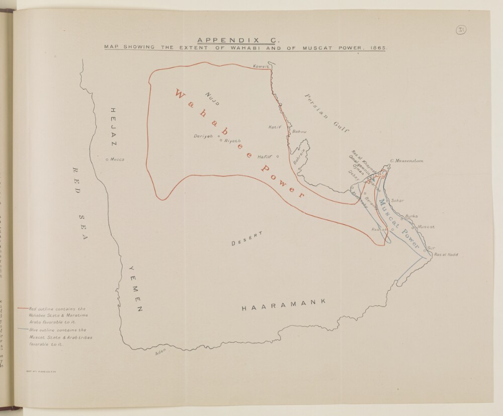
Abstract: Distinctive Features:Issued as an Appendix C in Bushire Despatch to Bombay No. 11 of 14th February 1865 with Wahabee State authority outlined in red and Muscat State limits shown in blue line.Physical description: Dimensions:336 x 415 mm
Abstract: Distinctive Features:Outline map of the Arabian Peninsula issued as an Appendix C in Bushire Despatch to Bombay No. 11 of 14th February 1865 (folios 60-90) with Wahabee State authority marked in red and Muscat State limits shown in blue line.Physical description: Dimensions:327 x 414 mm
Abstract: The map shows a central northern portion of the Arabian Peninsula and a south-western portion of Persia, indicating geographical regions, boundaries, hydrology, vegetation, routes, settlements and wells, with some indication of relief and brief descriptions of topography.An accompanying letter indicates that the map is a reproduction made by the Surveyor General in India. The map bears the printing statement, 'Survey Section[, General Staff, India] No. 911 Sept. 1940-20.'Physical description: Materials: Printed on paperDimensions: 1340 x 1015mm, on sheets 785 x 595mm
Abstract: Imprint:Lithographed in the Chief Engineer's Office by E. Huskeljee and E. Kumroodeen, Bombay.Distinctive Features:Relief shown by hachures.Below the title note ‘Reduced in the Quarter Master Generals Office from an Original Map by Colonel T Dickinson, Chief Engineer. Signed Neil Campbell, Lieutenant-Colonel, Acting Quarter Master General'.A detailed explanation of the various surveys, expeditions and engraved charts used to compile the map from 1819 to 1839 is given along with descriptions of the various routes shown on the map, and others which were referred to in the compiling of this map. The description was compiled by the Chief Engineers Office, Bombay, 4 April 1843.
Inscriptions:Numerous annotations concerning the routes, topography of the regions and local tribes, with submarine telegraph cable and two circles based on Ras Musandam and Bushire, inserted in black ink and pencil.The verso of the map contains a report written by Lewis Pelly, to the Chief Secretary to the Government of Bombay, 17 February 1863 on the landscape of the Persian Gulf, tribal ownership of coastline areas and pearl banks, and regarding the area surrounding Bushire. The report starts by describing the area from Kuwait to Dhahran, which Pelly claims is known as Adân [Al ‘Adān]; the area from Katiffe [Al Qaţīf] to Ojair [Al ‘Uqayr], which he refers to as Hujar, and the area from Ojair to the ports of the Beni Yas [Banī Yās] which he describes as Qatar. Within the Qatar area Pelly refers to Zabareh [Zubārah] which he describes as a place of note and considerable population and trade some 40 years previously. Pelly then proceeds to describe the areas the Wahabees [Wahhabi] claim ownership to; to describe the village of Cassab [Khaşab]; and to describe the pearl banks of the Persian Gulf, including their shared ownership, fishing processes, where the pearls are sold too, and how they are managed and patrolled during the pearl season. Further points made in the report include a possible overland route to Aden; and descriptions of Bushire including its agricultural population, estimated trade, taxes paid by local families. The report concludes by laying out possible ways in which the British Government and its armies could access Persia via Bushire or Hallilah [Heleh?] should they wish to launch a military offensive, including accessibility of various routes and the best times to travel on them.Physical description: Dimensions:520 x 721 mm; on sheet 575 x 916 mmFoliation:The map sheet has been foliated using a pencil number enclosed in a circle in the top right hand corner of the recto of the sheet.
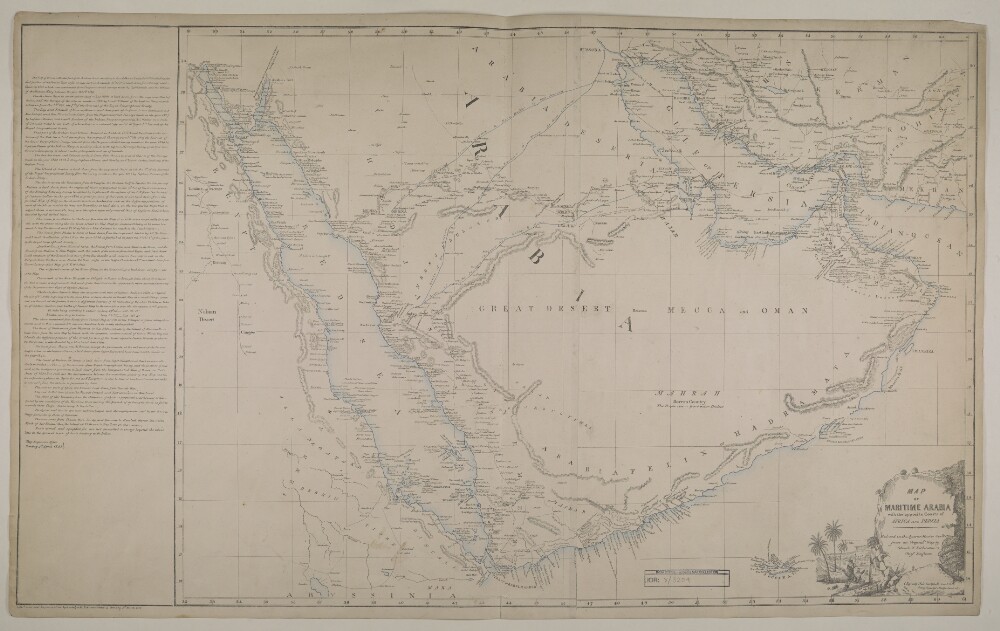
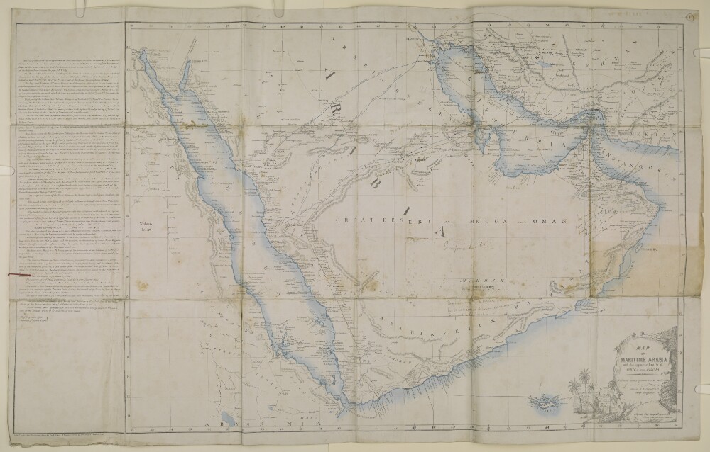
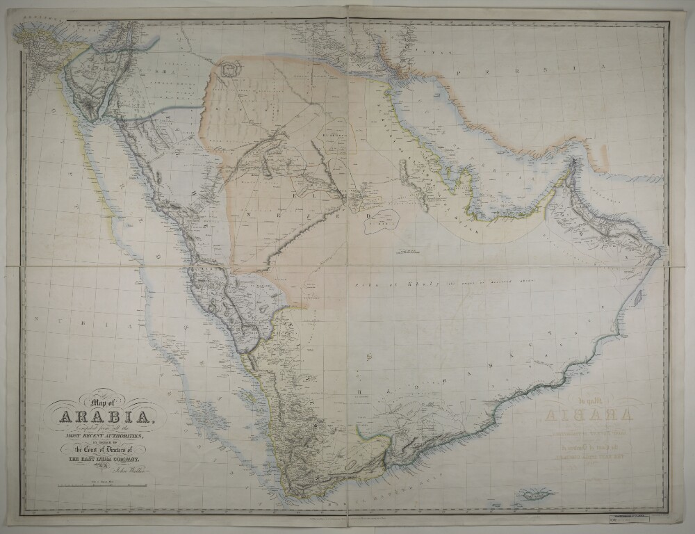
Abstract: Imprint:Published by J. Walker, Geographer to the Honble East India Company. Engraved by J.&C. Walker.Distinctive Features:Relief shown by hachures.Shows the approximate location of the major nomadic tribes across the region.Notations concerning the regions and topography, routes and distances between places of interest cover the face of the map.Provinces outlined in colour.Physical description: Dimensions:950 x 1270 mm
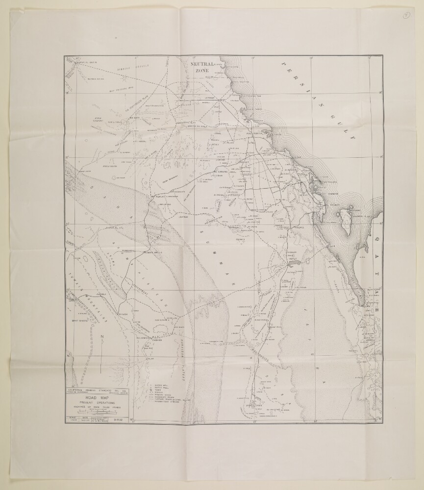
Abstract: The map shows a central northern portion of the Arabian Peninsula, indicating roads and camel routes, geographical regions, hydrology, vegetation, settlements and wells, with some indication of relief.An accompanying letter indicates that the map is a reproduction made by the Surveyor General in India. The map bears the printing statement, 'California Arabian Standard Oil Co. Producing Department Geological Division', and is dated 'Feb.24, 1940'.Physical description: Materials: Printed on paperDimensions: 615 x 530mm, on sheet 790 x 680mm
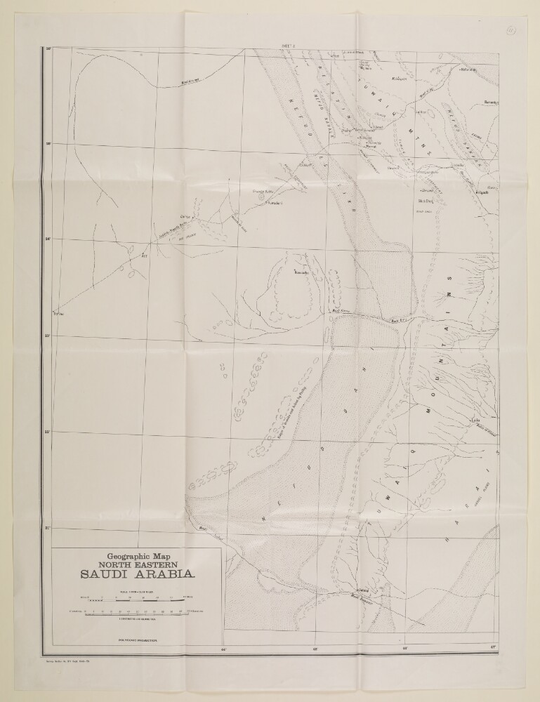
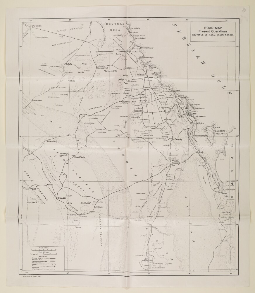
Abstract: The map shows a central northern portion of the Arabian Peninsula, indicating roads and camel routes, geographical regions, hydrology, vegetation, settlements and wells, with some indication of relief.The map bears the printing statement, 'Survey Section[, General Staff, India] No. 1228 Nov. 1940.'Physical description: Materials: Printed on paperDimensions: 633 x 537mm, on sheet 708 x 610mm
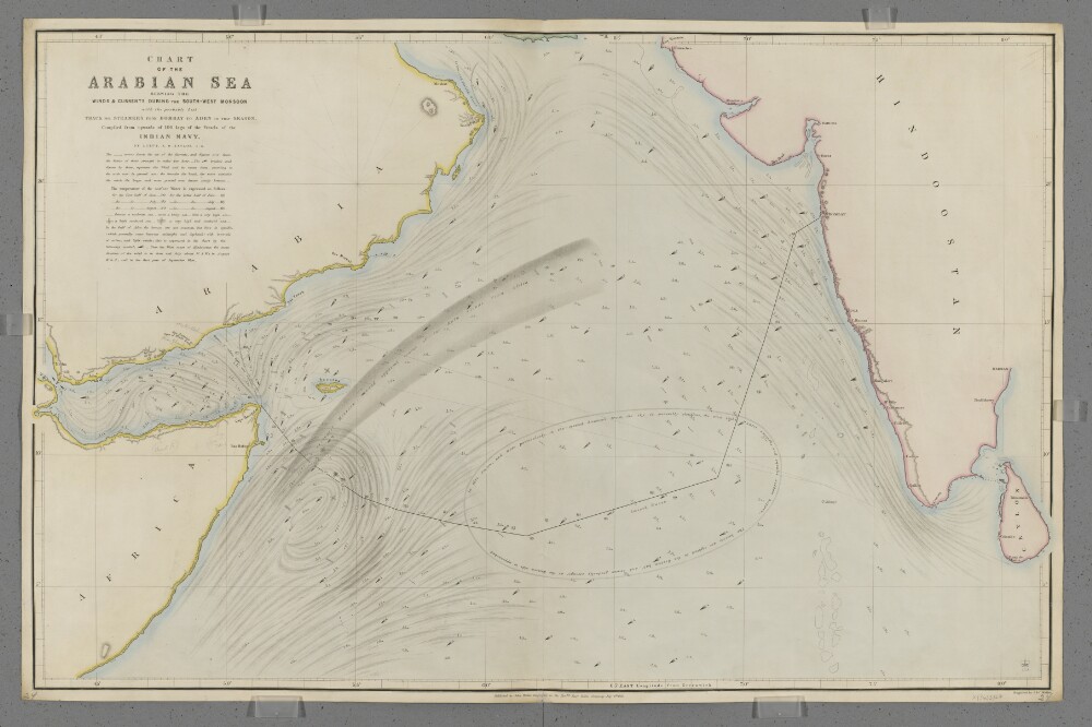
Abstract: Covers the Arabian Sea south of latitude 25°N, including the Gulf of Aden. Includes the coastlines of the Horn of Africa, the south-east Arabian Peninsula and the west coast of India. Includes a hinterland of approximately fifteen miles. Portrays hydrology, including rocks, relief by hachures, settlements, place names, and includes some navigational notes. Also shows meteorological information, including the strength and direction of currents and winds, surface water temperatures and sea turbulence, and includes meteorological notes and a suggested route for shipping between Aden and Bombay [Mumbai, India]. The chart has been enhanced with watercolour and some place names and routes added in pencil.Compiled by Lieutenant Alfred Dundas Taylor, Indian Navy. Engraved by J & C Walker. Published by John Walker, Geographer to the Honourable East India Company.Physical description: Materials: Printed, with manuscript additions in watercolour and pencil, on paper (backed with linen)Dimensions: 619 x 987mm, on sheet 654 x 1004mm