« Previous |
1 - 12 of 13
|
Next »
Number of results to display per page
Search Results
1. 'GENERAL REPORT ON THE ADMINISTRATION OF THE BOMBAY PRESIDENCY FOR THE YEAR 1865-66'
- Description:
- Abstract: Annual administration report of the Bombay Presidency, providing a summary record of the main events and developments in each department of the Government of Bombay during the financial year 1865-66.The report is divided into the following headings, some of which are further divided into sub-headings:‘JUDICIAL’ (ff 7-30), consisting of: Legislative; Civil Justice; Court of Small Causes; Criminal Justice; Police; Jails‘REVENUE’ (ff 31-42), consisting of: Land Revenue; Alienated Revenue; Income Tax; Customs, Salt and Opium‘FINANCIAL’ (ff 43-50), consisting of: Finance; Mint; Paper Currency‘POLITICAL’ (ff 51-58), consisting of: Political; Kattywar [Kathiawar]; Kutch [also known as Kachchh]; Rewankanta [Rewa Kanthar]; Khadeish; Surat; Sind [Sindh]; Aden; Persian Gulf‘PUBLIC WORKS’ (ff 59-117), consisting of: Military Army; Ordance; Commissariat; Military Finance Offices; Civil Buildings; Public Improvements‘PUBLIC WORKS – RAILWAY’ (ff 118-134) consisting of: GIP [Great Indian Peninsular] Railway; BB and CI [Bombay, Baroda and Central Indian] Railway; Sind Railway; Indus Valley Survey; Indus Steam Flotilla‘MILITARY’ (ff 135-161)‘PENSIONERS’ COLONY AT CHALLISGAUM [Chalisgaon]’ (f 162)‘INDO-EUROPEAN TELEGRAPH’ (ff 163-251). This section gives details on the Mekran [Makran] Coast and Musandam telegraph station. This section also has appendices: A (letter from Colonel Frederic John Goldsmid, Director in Chief of Indo-European Telegraph, and a report by Major Smith on the Island of Angaum [Hengam]); B (a report by Colonel Goldsmid of his journey through Turkish Arabia [Ottoman Iraq] and Asia Minor [Turkey]); C (a letter from Colonel Goldsmid and reports by himself, Major Smith of the Royal Engineers, and Mr Johnstone, British Agent at Busrah [Basra], of the journey from Ispahan [Isfahan] to Gwadur [Gwadar] to survey the land for connecting the Persian [Iranian] and Mekran Coast land lines of the telegraph); and D (a letter from Colonel Goldsmid with enclosure proposing an alternative land line from Gwadur to join the main Persian line between Bushire [Bushehr] and Tehran).‘PUBLIC INSTRUCTION’ (ff 252-258)‘MEDICAL’ (ff 259-260)‘SURVEYS’ (ff 261-265), consisting of: Revenue Survey; Topographical Survey‘FORESTS’ (ff 266-268)‘EMIGRATION’ (f 269)‘MILLS’ (ff 270-272)‘MUNICIPAL’ (ff 273-275)‘ECCLESIASTICAL’ (ff 276-277)‘COTTON FRAUDS DEPARTMENT’ (ff 278-279)‘POPULATION, SIND’ (f 280)‘AGRICULTURE, SIND’ (f 281).A table of contents listing the headings and sub-headings of the report is on folios 5-6. There are two maps relating to surveys of the Indo-European Telegraph line.Physical description: 1 item (278 folios)
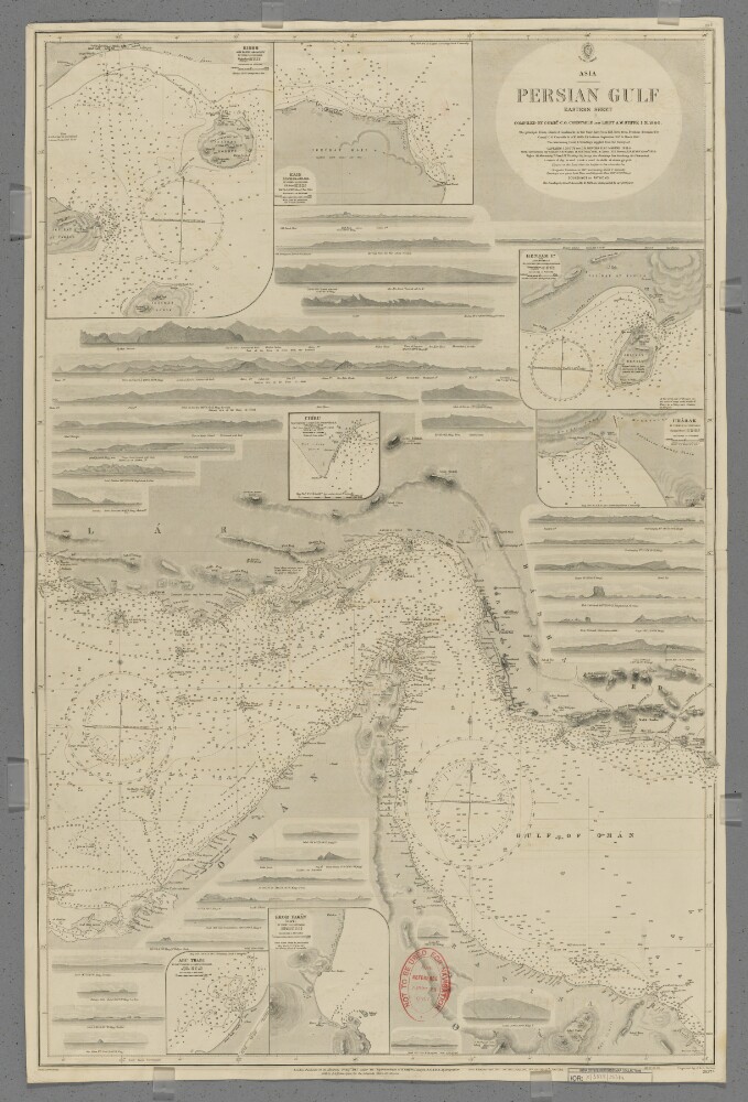
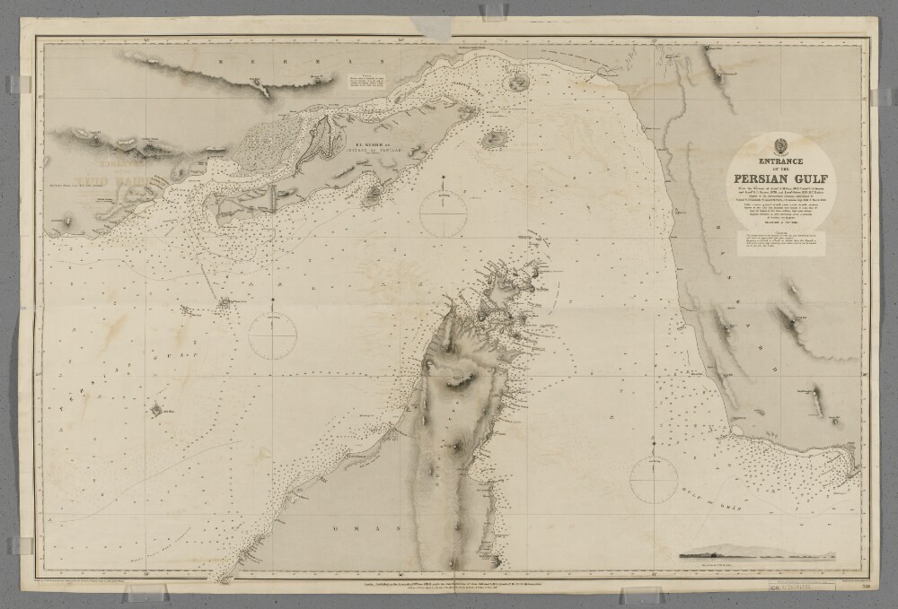
2. 'Persian Gulf. Eastern Sheet'
- Description:
- Abstract: Chart 2837a.Hydrographic chart covering the Strait of Hormuz and the adjoining sections of the Persian Gulf and Gulf of Oman. Also includes the adjacent coastal areas of Persia [Iran] and the Musandam Peninsula. Portrays hydrology, including depths by soundings and contours, anchorages, sands and rocks, relief by spot heights, hachures and rock drawings, vegetation, settlements, forts and place names, and includes topographical notes and navigational aids, including lights and prominent landmarks.Includes insets of Kishm, Persia [Qeshm, Iran] at scale 1:145,826; Kais to Bandar Abbas, Persia [Kish to Bander-e Abbas] at scale 1:72,913; Henjam Island, Persia [Hengam Island] at scale 1:145,826; Charak, Persia [Bandar-e Charak] at scale 1:145,826; Chiru, Persia [Bandar-e Chiruyeh] at scale 1:72,913; Khor Fakan, Oman [Khawr Fakkan, United Arab Emirates] at scale 1:60,760; and Abu Thabi, Trucial Oman [Abu Dhabi, United Arab Emirates] at scale 1:72,913.Thirty-three annotated sketches of significant navigational views at unspecified scales on both the north and south coasts are also included.Chart surveyed and compiled by Commander Charles Golding Constable and Lieutenant Arthur William Stiffe, Indian Navy (1860); also incorporates surveys by Captain John Michael Guy and Captain George Barnes Brucks, East India Marine (1821-1829); with corrections by Commander Frederic Henry Walter and Lieutenant H T Bowen, Royal Navy (1910). Engraved by J & C Walker. Published at the Admiralty 1862, with new editions 1865, 1890, 1910, 1911 and 1912, and small corrections.The sheet bears the stamps:'Not to be used for navigation. For reference purposes only' in red on the map face.The number '20.2' in black in the upper right margin.Physical description: Materials: Printed on paperDimensions: 960 x 636mm, on sheet 1003 x 665mm
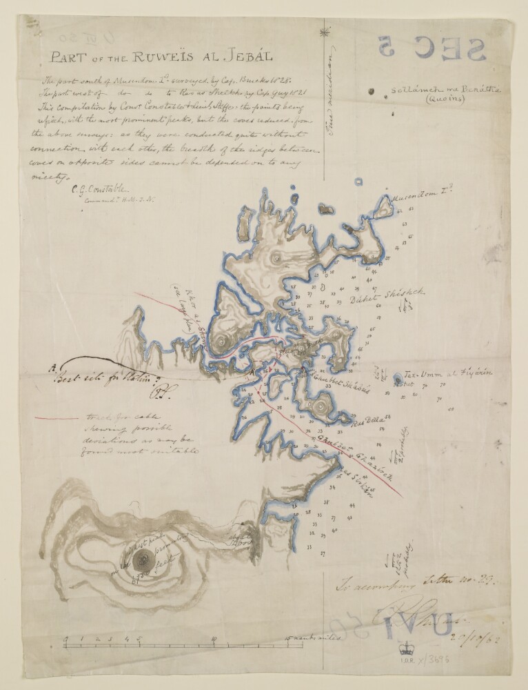
3. ‘Part of the Ruweïs at Jebál’
- Description:
- Abstract: Distinctive Features:Depths shown by soundings.The proposed track of the Telegraph Cable south of Cape Musondom shown in red line.Inscriptions:On recto in the upper left-hand corner below title an explanatory note on survey and sources, signed 'C.G. Constable Commandr. H.M.I.N.'.In the lower right-hand corner in later hand: ‘To accompany Letter no. 29, P. Stewart. 20/10/62’.Physical description: Materials:Pen and ink on tracing clothDimensions:380 x 280 mm

4. 'Chart of The Gulf of Persia.'
- Description:
- Abstract: Sheet 1 (Eastern) bears the shelfmark IOR/X/3635/1Sheet 2 (Western) bears the shelfmark IOR/X/3635/2Covers the Persian Gulf, Strait of Hormuz and the coastlines of Persia [Iran], Mesopotamia and the north-eastern Arabian Peninsula eastwards to the Musandam Peninsula. Includes a hinterland of approximately twelve miles. Portrays hydrology, including depths by soundings, and rocks, relief by hachures and rock drawing, vegetation, settlements and place names in English and Arabic, and includes topographical and hydrographic notes. The coastlines are highlighted in watercolour.'Constructed from the Trigonometrical Surveys. Made by Order of the Hon[ourab]le the Court of Directors of the United English East India Company; and to whom it is Respectfully Dedicated by their most obedient Servant George Barnes Brucks, Commander HC [Honourable Company] Marine. 1830.'Original surveys by Lieutenants John Michael Guy, George Barnes Brucks, Robert Cogan, William Eales Rogers and Stafford Bettesworth Haines, 1821-29. Engraved by Richard Bateman. Published by James Horsburgh, Hydrographer to the Honourable East India Company, 1832.Physical description: Materials: Printed, with manuscript additions in watercolour, on paper (backed with linen)Dimensions: Sheet 1 (Eastern) 725 x 580mm, on sheet 803 x 644mm; Sheet 2 (Western) 731 x 580mm, on sheet 820 x 648mm
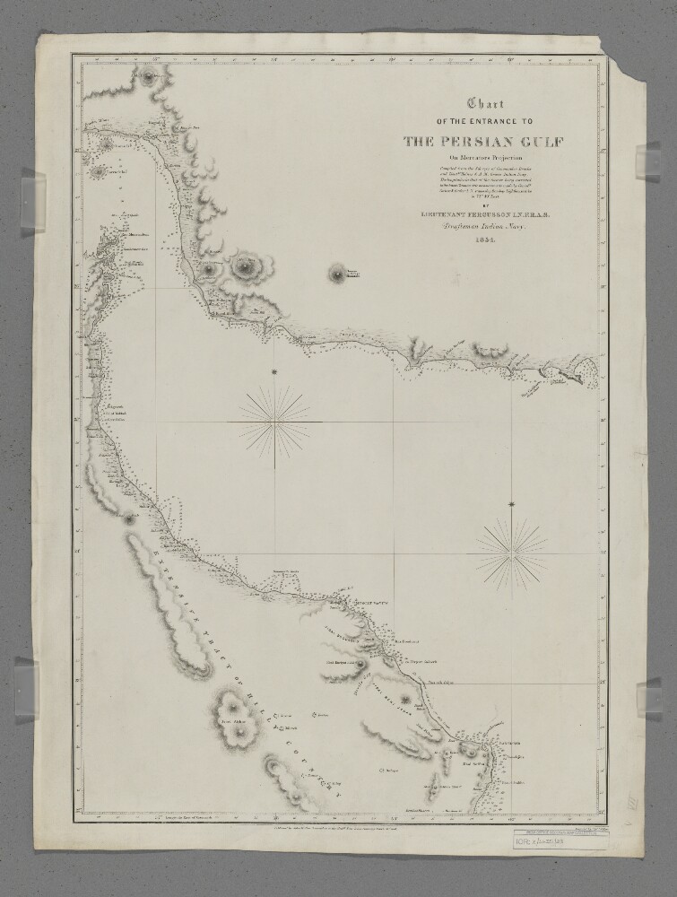
5. 'Chart of the Entrance to the Persian Gulf'
- Description:
- Abstract: Covers the eastern part of the Strait of Hormuz, the western part of the Gulf of Oman and the coastlines of southern Persia [Iran], northern Oman and the eastern side of the Musandam Peninsula, including a hinterland of approximately thirty miles. Portrays hydrology, including depths by soundings, sands and rocks, relief by hachures, rock drawing and occasional spot heights, vegetation, settlements, forts and place names, and includes topographical notes.Compiled by Lieutenant E F T Fergusson, Indian Navy from the surveys of Commander George Barnes Brucks and Lieutenants Stafford Bettesworth Haines and Albany Moore Grieve, Indian Navy, 1854. Engraved by J & C Walker. Published by John Walker, Geographer to the Honourable East India Company, 1857.Physical description: Materials: Printed on paperDimensions: 426 x 620mm, on sheet 678 x 508mm
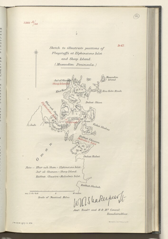
6. 'Sketch to illustrate positions of Flagstaffs at Elphinstone Inlet and Sheep Island (Musandim Peninsula)'
- Description:
- Abstract: A sketch of the Musandim Peninsula [Shibh Jazīrat Musandam], including Elphinstone Inlet [Khawr ash Shamm], Sheep Island [Jazīrat Umm al Ghanam] and Malcolm's Inlet [Ghubbat al Ghazira].The sketch is signed by William Henry Irvine Shakespear, Assistant Resident and HM Consul at Bandar Abbas.The scale is given in nautical miles.Physical description: Materials: printed on paper.Dimensions: 325 x 205mm
7. 'Entrance to the Persian Gulf'
- Description:
- Abstract: Chart 753.Hydrographic chart covering the Strait of Hormuz and the adjoining sections of the Persian Gulf and Gulf of Oman. Also includes the adjacent coastal areas of Persia and the Musandam Peninsula. Portrays hydrology, including depths by soundings and contours, anchorages, sands and rocks, relief by spot heights and hachures, vegetation, settlements, forts and place names, and includes topographical notes and navigational aids, including buoys, beacons and prominent buildings.Includes an annotated sketch view, at unspecified scale, of Koh Mubarak, Persia [Kuh Mobarak, Iran] from the west by south at twelve miles distant.Chart produced from the surveys of Lieutenant John M Guy (1822), Commander George Barnes Brucks and Lieutenant Stafford Bettesworth Haines (1828) and Lieutenant Albany Moore Grieve (1839), Honourable Marine. Astronomical positions determined by Commander Charles Golding Constable and Lieutenant Arthur William Stiffe, Indian Navy (1857-60). Engraved by Davies, Bryer & Company. Drawn by Edward James Powell, Hydrographic Office. Published at the Admiralty, 1872.Physical description: Materials: Printed on paperDimensions: 640 x 968mm, on sheet 682 x 1017mm
8. 'Memo on Mussondomom'
- Description:
- Abstract: This is a copy of a printed memorandum, with correspondences by Lieutenant-Colonel Lewis Pelly, the Political Resident in the Persian Gulf at Bushire, dated January to February 1863, concerning locating the Persian Gulf Residency at Cape Mussundoom [Musandam]. In letter No. 2A (folios 1-4), dated 1 February 1863, with post-scripts dated 2 February 1863, to the Honorable Henry Lacon Anderson, Chief Secretary to Government in the Political Department, Bombay, Pelly enumerates some of the benefits of changing the location to Musandam and poses thirteen points for consideration should Government approve. Following this is an earlier letter, No. 1A (folios 5-9), dated 12 January 1863, Pelly writes to Anderson with his original memorandum proposing the change of location for the Persian Gulf Residency in the context of developing the Persian Gulf steam line and telegraphic communication. Pelly gives an overview to the background in which Bushire was chosen as the location for the Residency and why it was not well selected, and then gives reasons why Musandam would be better suited. Pelly lists eleven reasons, which include: centrality, telegraphic station, coal depot, and strategic location for policing piracy.Physical description: Foliation: The foliation sequence commences at the front cover, and terminates at the inside back cover; these numbers are written in pencil, are circled, and are located in the top right corner of the recto side of each folio.Pagination: The volume also contains an original printed pagination sequence.
9. File 351/1904 'Persian Gulf:- Erection of British flagstaffs at Musandam’
- Description:
- Abstract: The volume comprises correspondence and other papers relating to the erection (and subsequent abandonment) of flagstaffs at the head of the Persian Gulf, on the Maklab [Maqlab] Isthmus at Musandam (Musandam spelt with numerous variations throughout the file), Telegraph Island [Jazīrat al Maqlab], and Sheep Island [Jazīrat Umm al Ghanam].The correspondence includes:a report of the Viceroy of India’s tour of the Persian Gulf in 1903, dated 21 January 1904 and signed by several individuals (including George Nathaniel Curzon and Horatio Herbert Kitchener) containing proposals for the erection of naval bases, coaling stations, and telegraph facilities in the Gulf (ff 213-215);proposals and arrangements for the erection of flagstaffs by HMS Sphinxin November 1904, made by Major William George Grey, Political Agent at Muscat, Lieutenant William Henry Irvine Shakespear, Assistant Resident and Acting British Consul at Bunder Abbas [Bandar-e ʻAbbās], Captain Thomas Webster Kemp, Senior Naval Officer in the Persian Gulf and Commander of HMS Sphinx, including reports submitted by Shakespear and Kemp describing the erection of the flagstaffs, including accounts of the discussions held with the inhabitants of the areas around which the flagstaffs were erected, and a map indicating the location of the flagstaffs (ff 112-114, 119-121);questions of whether to fly the Union Jack or Blue Ensign on the flagstaffs;Government concerns that the flagstaffs were situated in territory claimed by the Sultan of Maskat [Muscat];Admiralty objection to the flagstaffs, on the grounds that it would be the Navy’s responsibility to protect them;the decision of the Committee of Imperial Defence (CID) to maintain the flagstaff at Telegraph Island, but abandon the flagstaffs at the Maklab Isthmus and Sheep Island;further reconsideration of the proposal to fly a British flag on Telegraph Island, in the wake of investigations by John Gordon Lorimer which assert the Sultan of Muscat’s sovereignty over Musandam;deferral of the decision on the flagstaff at Telegraph Island until the outcome of the Hague Tribunal on vessels at Muscat flying the French flag; the removal, in October 1905, of the flagstaffs on the Maklab Isthmus and Sheep Island;final instruction from the Foreign Office to the Government of India, in May 1908, that the remaining flagstaff on Telegraph Island should be no longer maintained.The file also includes a report of the survey of Khor Kawi [Khawr al Quway‘] by HMS Sphinx, dated 31 December 1903, with a map showing water depths in Khor Kawi (ff 190-192), and a letter from the Commander-in-Chief of the East Indies Station, Vice Admiral George L Atkinson-Willes, to the Government of India, dated 5 September 1905, recommending that Khor Kawi be used as a new British naval base, rather than Elphinstone Inlet or Telegraph Island (ff 34-35).The volume includes a divider which gives the year that the subject file was opened, the subject heading, and a list of correspondence references contained in it arranged by year. This divider is placed at the front of the volume (f 3).Physical description: Foliation: the foliation sequence commences at the inside front cover with 1, and terminates at the inside back cover with 225; these numbers are written in pencil, are circled, and are located in the top right corner of the recto side of each folio. A previous foliation sequence, which is also circled, has been superseded and therefore crossed out.
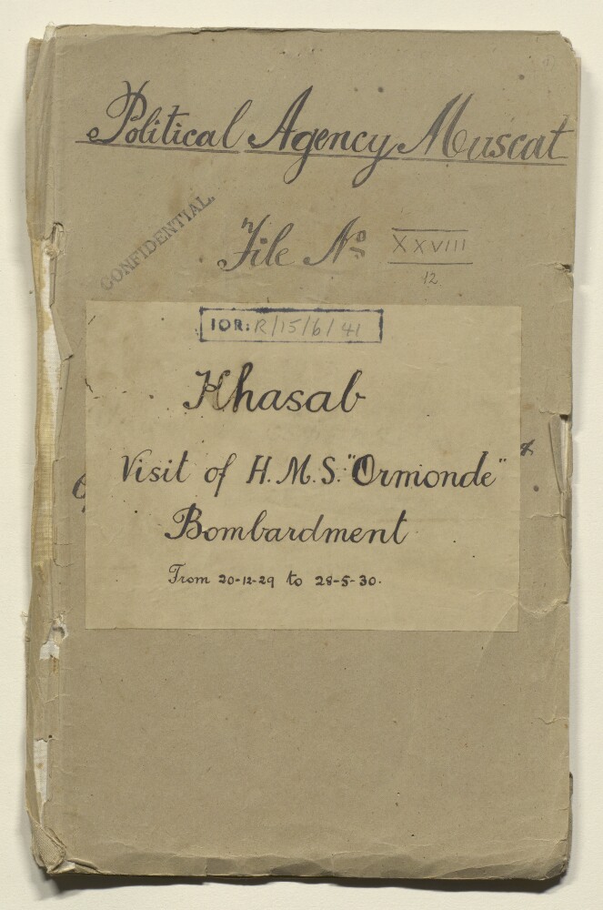
10. ‘File No XXVIII/12 Khasab Visit of H.M.S. “Ormonde and Bombardment from 20-12-29 to 28-5-30.’
- Description:
- Abstract: The file contains correspondence in the form of telegrams and reports between the Political Agency, Muscat, the Political Residency in the Persian Gulf, Bushire, and the naval officers on board HMS Ormondeand HMS Lupin. The correspondence is concerned with the ship HMS Ormondeleaving Aden to carry out surveys in the Gulf and the question of whether a survey would be permitted to take place in Oman or not. While the Council of Ministers to the Sultan of Muscat and Oman granted permission for a survey to take place, further permissions were required from the shaikhs of Khassab, Bukha, Diba and Kumzar, which are parts of the region of Musandam in Oman. Some tribes from the region, the Shihuh in particular, opposed the landing of the navy ship in their territories. The Political Resident warned that the landing of any British personnel in Shihuh region would be attended by grave risk in the future.To subdue the shaikhs of Khassab, the Political Resident recommended to the Government of India that the Naval Ship HMS Lupin, should be authorised to carry out a bombardment of parts of Khassab and, in the event of the shaikhs’ withdrawal to the mountains, this should be followed by a blockade of the Khassab area. British officials were also concerned with the necessity of reaching agreements with the Trucial Shaikhs and with those of the region of Musandam. The file also includes correspondence with the Council of Ministers at Muscat regarding the imprisonment of the Shaikh of Khassab, Hasan bin Muhammad.Physical description: Foliation: the main foliation sequence (used for referencing) commences at the front cover with 1, and terminates at the inside back cover with 161; these numbers are written in pencil, are circled, and are located in the top right corner of the recto side of each folio. An additional foliation sequence is present in parallel between ff 3-160; these numbers are also written in pencil, but are not circled.
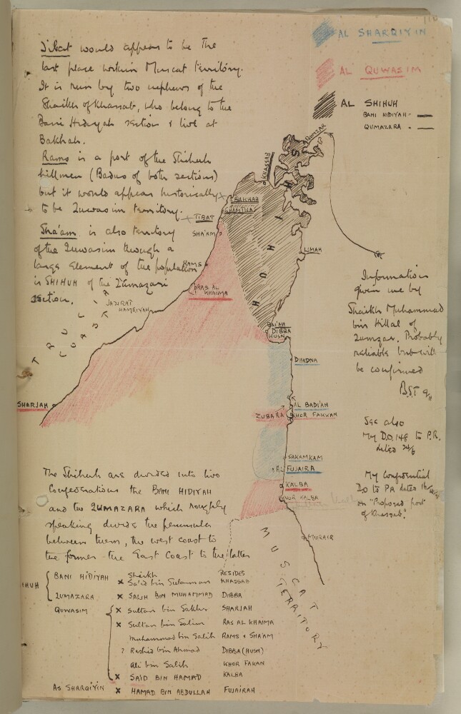
11. Map of the Masandam Peninsula by Bertram Thomas
- Description:
- Abstract: Distinctive Features:The Trucial Chiefs' territories shown in colour with ports labelled and underlined accordingly, and a key provided in the upper-right hand corner.Includes descriptive notes on territories and their rulers with a table listing Sheikhs’ names and their residences in the lower part of the sheet.Physical description: Materials:Pen and ink with crayon on paperDimensions:326 x 208 mm
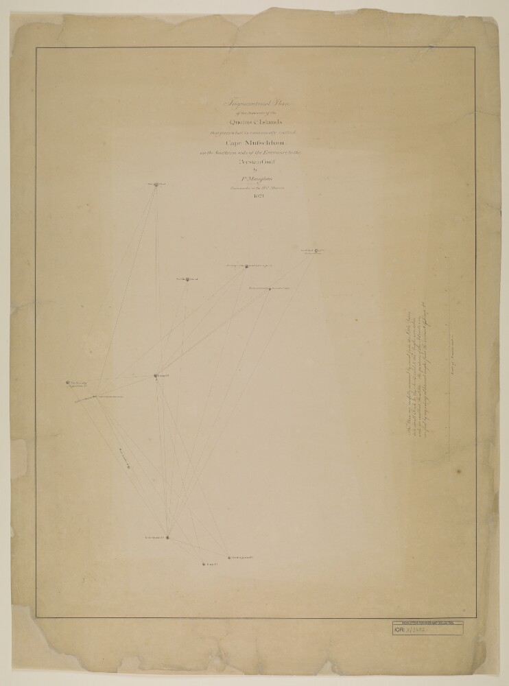
12. ‘Trigonometrical Plan of the Summits of the Quoins & Islands that form what is commonly called Cape Musseldom on the Southern side of the Entrance to the Persian Gulf by P. Maughan, Commander in the H.C. Marine. 1821’
- Description:
- Abstract: Distinctive Features:Hand drawn nautical chart of the entrance of the Persian Gulf compiled from the survey carried out by the Bombay Marine’s officers in 1821. Shows positions of the islands off the shore of the Musandam Peninsula with a network of lines based on survey’s control points inserted on the map.Includes a descriptive note with remarks on survey execution in the centre right of the sheet.Physical description: Materials:Pen and ink on paperDimensions:637 x 492 mm, on sheet 745 x 550 mm
- « Previous
- Next »
- 1 Current Page, Page 1
- 2