Abstract: The file concerns the possibility of establishing an international Conservancy Board for the Shatt-el-Arab (also referred to as the Shatt-al-Arab) between the governments of Iraq, Iran (also referred to as Persia), and the United Kingdom.The board was intended to ensure the efficient maintenance and navigation of the Shatt-al-Arab waterway. The United Kingdom was involved because of the close interests of British shipping in the conservancy of the Shatt-al-Arab.The papers cover: Perso-Iraqi frontier negotiations; drafts, signing (July 1937), and ratification (June 1938) of the Perso-Iraqi Frontier Treaty; Turkish approval of the frontier negotiations; the signing of the four power non-aggression pact between Iraq, Iran, Turkey, and Afghanistan (the Saad-Abad [Saadabad] Pact), 1937; Abadan anchorage; Foreign Office memoranda and minutes of meetings concerning a convention for the conservancy of the Shatt-al-Arab; the question of British participation in the convention; lighting and buoying; the involvement of Sir John Ward [serving with the Iraqi Government] in the discussions; the opposition of the Iranian Government to British involvement; the involvement of the Anglo-Iranian Oil Company (AIOC); the Port of Basra (including Foreign Office memorandum, folios 77-83); the Rooka Channel; and renewed discussion of the issue in 1945, including the importance of the Shatt-al-Arab for tanker traffic to supply Britain's war needs in the Far East.The main correspondents are the Foreign Office, the British Ambassador to Iraq, and HM Minister, Tehran.The French language content of the file consists of approximately twenty folios of diplomatic correspondence and treaties.There are no papers in the file dated 1941-44.The file includes a divider, which gives a list of correspondence references contained in the file by year. This is placed at the back of the correspondence.Physical description: Foliation: this file consists of two physical parts. The foliation sequence commences at the first folio of part one (ff 1-169) and terminates at the last folio of part two (ff 170-329); these numbers are written in pencil, are circled, and are located in the top right corner of the recto side of each folio. An additional foliation sequence is present in parallel; these numbers are printed, but are not circled. A previous foliation sequence, which is circled, has been superseded and therefore crossed out. The front and back conservation covers (parts one and two), have not been foliated.
Abstract: Handwritten report, in Lewis Pelly's handwriting about the history of the Shat el Arab [Shatt al Arab] watercourse from the point where it commences at the uniting of the Tigris and Euphrates rivers through to where it flows into the Persian Gulf.The reports goes on to describe the agriculture along the watercourse; the deserts beyond; and information about Basrah [Basra] including architectural descriptions and the ruined city of Zobeir [Zubayr].The report also includes accounts of attacks on the area by nomadic Bedouins who travel the area in winter searching for pastures; the development of a settlement, trade and a Government at Khote [Kuwait], including a description of Pelly's visit there en-route to Riadh [Riyadh]; and giving detailed descriptions of the Sheikh, conversations about Pelly's proposed trip and details of the hospitality Pelly received there.The report concludes by recounting a story told by Sheikh Sabba [Sabah II bin Jabir Al-Sabah] of two slave girls and their families' efforts to find and be reunited with them.The report itself is undated, but would have been written sometime after Lewis Pelly's trip to Riyadh which took place February to March 1865.Physical description: 40 folios
Abstract: Two draft copies of a report written by Lewis Pelly of the coastline from Al Katif [Al Qatif] to Koweit [Kuwait] and his journey onwards from there to Riyath [Riyath]. The report contains names and descriptions of key geographic areas and features travelled through en-route.The contents of this draft report were included as part of Lewis Pelly's full report on his journey to Riyadh to meet with Amir Faysul [Faisal ibn Turki al-Sa'ud].Both draft copies contain crossings out and corrections.Physical description: 7 folios
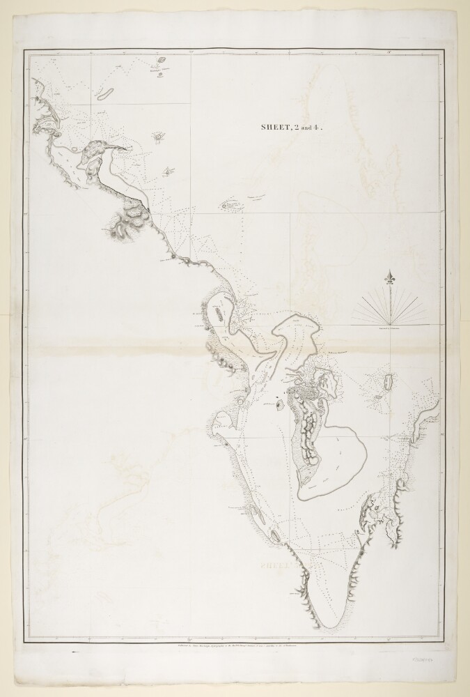
Abstract: Imprint:Published by James Horsburgh, Hydrographer to the East India Company.Distinctive Features:Relief shown by hachures. Depth shown by soundings.Nautical chart of the Arabian side of the Persian Gulf showing the coastline from Ras el Ghar with the Island of Bahrein and the western shores of the Qatar Peninsula compiled from the surveys carried out by the Bombay Marine’s officers between 1820 and 1829.Uqair in the Eastern province of Saudi Arabia labelled ‘Formerly Port to the Wahabee, Capital, Deriah’. Hawar Islands off the west coast of Qatar labelled ‘Wardens Islands’.Physical description: Dimensions:878 x 620 mm, on sheet 1019 x 677 mm
Abstract: Incomplete memorandum, written in pencil, regarding the tribute that Amir Faisaul ibn Turki al Sa'ud of the Wahabees [Wahhabi] pays to the Porte and the revenues he receives both in terms of money and horses as well as in military aid.The memorandum also refers to agreements with other tribes who can travel unmolested through Nejd [Najd] territory.The verso of folio 74 contains the first line of a memorandum regarding writing to someone.The memorandum itself is undated, however the information contained within it would have been acquired by Lewis Pelly during his visit to Riyadh, February to March 1865.Physical description: 2 folios
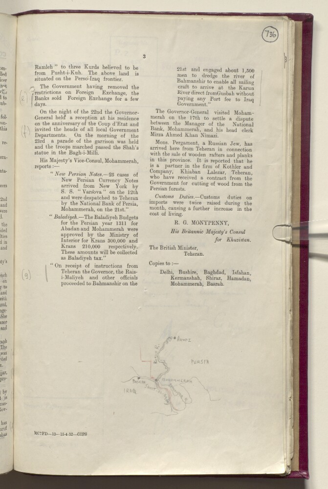
Abstract: Pencil sketch showing the border region between Iraq and Persia [Iran]. The map indicates the Karun and Bahmanshir rivers, the coastline of the Persian Gulf and the Shatt al-Arab, and the towns of Ahwaz [Ahvāz], Mohammerah [Khorramshahr], and Basrah [Basra]. A red pencil line indicates the border between Iraq and Persia. The map refers to a portion of the report on the same folio, which mentions instructions issued by Persian Government officials to dredge the Bahmahshir ‘to enable all sailing craft to arrive at the Karun River direct from Gusbah [Qoşbeh-ye Manī‘āt] without paying any Port fee to Iraq Government’.Physical description: Dimensions: 60 x 80 mm.Materials: pencil on paper.
Abstract: Distinctive Features:Hand drawn sketch map showing Dawḩat Salwá and area west of Salwa, attached to a letter No. C/38-1.a/38 dated 25 January 1936, to illustrate a dispute concerning Saudi-Qatar boundary.Physical description: Materials:Pen and ink on paperDimensions:328 x 185 mm
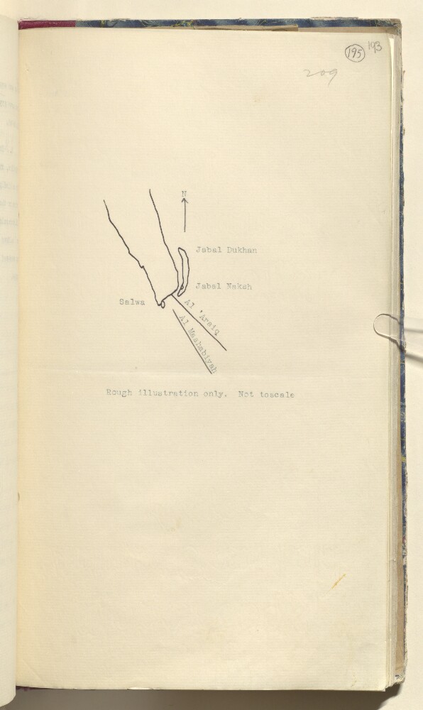
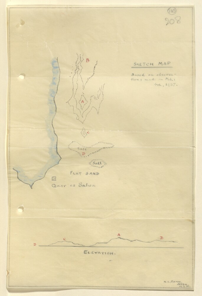
Abstract: Distinctive Features:Relief shown by hachures.Tracing of a rough sketch map based on observations made on 4th March 1937, showing area north of Qasr es Salwa in Qatar with landmarks lettered for reference. Includes corresponding elevation profile in the lower portion of sheet.Signed and dated in the bottom right-hand corner: ‘N.L. Forter, Jedda, 19.3.37’.Physical description: Materials:Pen and ink with wash on tracing paperDimensions:293 x 194 mm
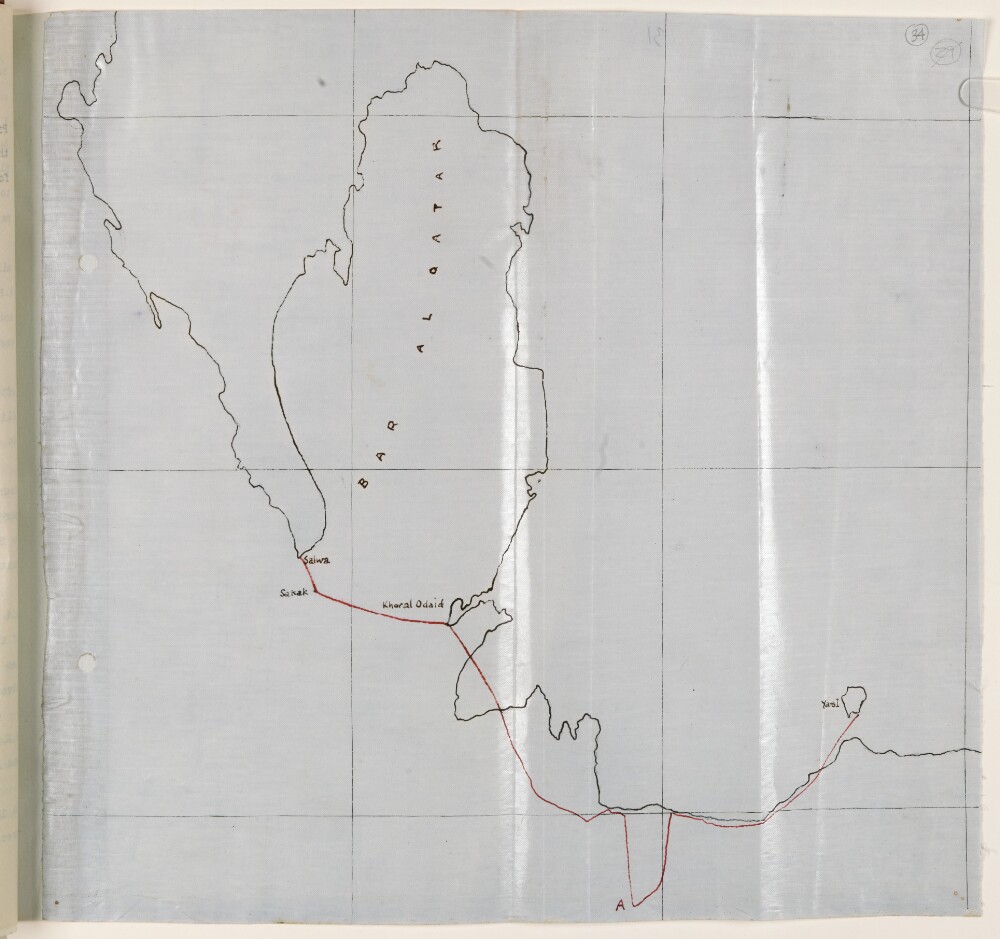
Abstract: Distinctive Features:Unsigned and undated.Hand-drawn map with the route of the Qatar Air Reconnaissance carried out by Lieutenant-Colonel Gordon Loch on 29th June 1934 shown by red line.Physical description: Materials:Pen and ink on tracing clothDimensions:322 x 335 mm
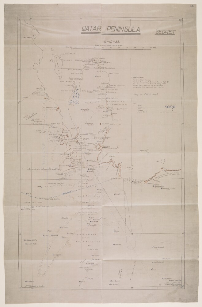
Abstract: Imprint:A.H.Q. [Air Headquarters] Drawing Office Iraq. Drawn by Aprim Bet-Benjamin, Nov. 1935.Distinctive Features:Relief shown by hachures.Map showing the Qatar Peninsula and central part of the Eastern Province Saudi Arabia. Numerous notations concerning terrain features cover the face of the map with routes, the location of wells with good water, and sandy and marshy areas marked.Includes a key to symbols and a list of sources used in compilation of the map.Inscriptions:On verso is an annotation in black ink: ‘Received under Air Officer Commanding, British forces in Iraq’s letter No. S. 10843/2411 dated 19th November 1935; file 61/31. With initials and date ‘12/12/35’.Physical description: Materials:Photographic print with additions in ink and crayon on tracing clothDimensions:592 x 357 mm, on sheet 670 x 431 mm
Abstract: Two letters from William Digges Latouche, Resident at Bussora [Basra], to the Secret Committee of the Court of Directors for Affairs of the United Company of Merchants of England trading to the East Indies (East India Company).The first letter, dated 30 March 1783, covers subjects including:The movement of ships and transit of mail from London to India via BussoraDisruption to the mail route caused by ships from Grain [Kuwait] at the mouth of the River [Shatt al-Arab]The suspension of talks between the Basha [Büyük Sulaymān Pāshā, Governor of Baghdad] and the Ghesaal Arabs [Khazā‘il tribe], which threatens communication between Bagdat [Baghdad] and Bussora.The second letter, dated 23 April 1783, covers:Latouche’s meetings with M Cotinal, a French messenger travelling to India, and attempts to delay his journeyThe movement of ships and British travellers and the transit of mail via BussoraThe arrival in Bussora of a consignment of woollensThe restitution of goods taken by Grain, and the Shaik [Shaikh] of Grain’s request for a loan.Another copy of the same letter can be found in IOR/L/PS/9/76/28.Physical description: 1 item (3 folios)
Abstract: The letter from Lieutenant-Colonel William George Grey to Sir Frederic Arthur Hirtzel encloses a copy of a letter No. C/8 of 1915 by Grey, as Political Agent in Kuwait, to the Political Resident in the Persian Gulf, dated 9 June 1915, regarding Arab co-operation with the Turks in the Shatt al-Arab [Shaṭṭ al-‘Arab] country.The letter refers to remarks made by Lord Curzon of Kedleston both in the House of Lords and in relation to an address given by Mr P Landon on Basrah and the Shatt al-Arab at the Society of Arts in April 1915. The remarks are regarding Arab tribes supporting the Turks, and further observations made by the Secretary of State for India on the Battle of Shaiba, at which it was reported that the Turkish troops had been joined by almost 10,000 Arab combatants. The letter also raises the question of why they were now siding with the Turks given their previous relations with Britain.Grey's response to these observations includes a detailed explanation of the composition of the tribes involved as being primarily from Arab communities in Iraq, and the Muntafiq [al-Muntafiq] tribe of the Euphrates and Shatt-ul-Gharaf [Shaṭṭ al-Gharrāf, also known as Shaṭṭ al-Ḥayy] regions. His response also notes that the tribes involved are not those of the Persian Gulf region as had previously been assumed by Lord Curzon.The letter goes on to explain these tribes' relations with the Turks and the reasons for their having sided with them. The letter concludes by providing information on some of the tribes of the Persian Gulf, in particular the Zaffir [al-Zafīr] who had declined Turkish invitations to take up arms; and the Yuarin, Bani Malik [Banī Mālik] and Shammar all of whom had chosen to remain neutral.Physical description: Foliation: The foliation for this description commences at folio 26 and terminates at folio 26, as it is part of a larger physical volume; these numbers are written in pencil, are circled, and are located in the top right corner of the recto side of each folio. An additional foliation sequence is also present in the volume; these numbers are also written in pencil, but are not circled, and can be found in the same position as the main sequence.